Cite this as: Devos, Y., De Cupere, B., Speleers, L., Van de Vijver, K., Van Schepdael, N., Vrydaghs, L. and Degraeve, A. 2025 A Matter of Scale: Developing a Framework for Environmental Archaeology in Brussels, Internet Archaeology 70. https://doi.org/10.11141/ia.70.9
Over the last few decades there has been an increasing awareness of the importance of archaeoenvironmental research in urban archaeology, often closely associated with rescue and preventive archaeology. The proceedings of the first Conference on the Environmental Archaeology of European Cities (CEAEC) held in Brussels in 2015 demonstrate the large scope of topics that need to be dealt with, including the study of complex urban stratigraphy and urban dark earths, aspects of taphonomy, the study of individual households, the organisation of public space and food consumption patterns, and the relevance for the wider urban archaeological community (Devos et al. 2017b). Many of these archaeoenvironmental studies in urban archaeology, however, focus on a few emblematic sites within towns and cities, and, despite some very illuminating exceptions (see for instance Macphail 1994; Roberts and Cox 2003; Golding 2008; van Haaster 2008; Macphail 2010; Badura et al. 2014; Ervynck and Van Neer 2017; Grau-Sologestoa et al. 2017; Bronnikova et al. 2023), overarching research on an urban or even a regional scale is not yet the custom.
This growing interest in archaeoenvironmental research is particularly well expressed for the historical centre of Brussels, Belgium, where environmental archaeology has played a pivotal role in archaeological research since the beginning of the 21st century (Degraeve 2015). Importantly, from the very beginning, the focus has been on both the study of individual sites and synthesis at a neighbourhood/city level.
Such an approach, however, poses several challenges, as outlined below.
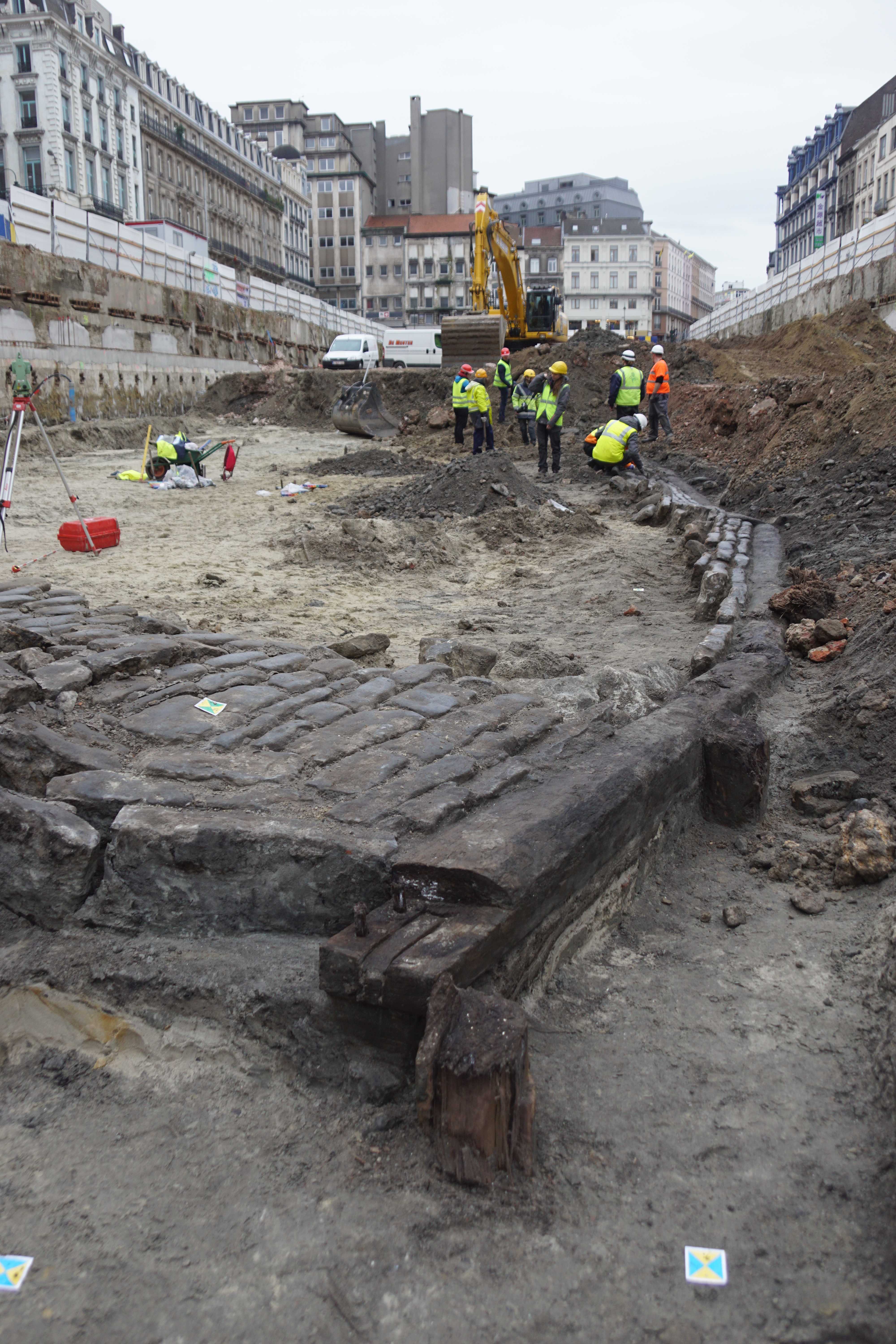
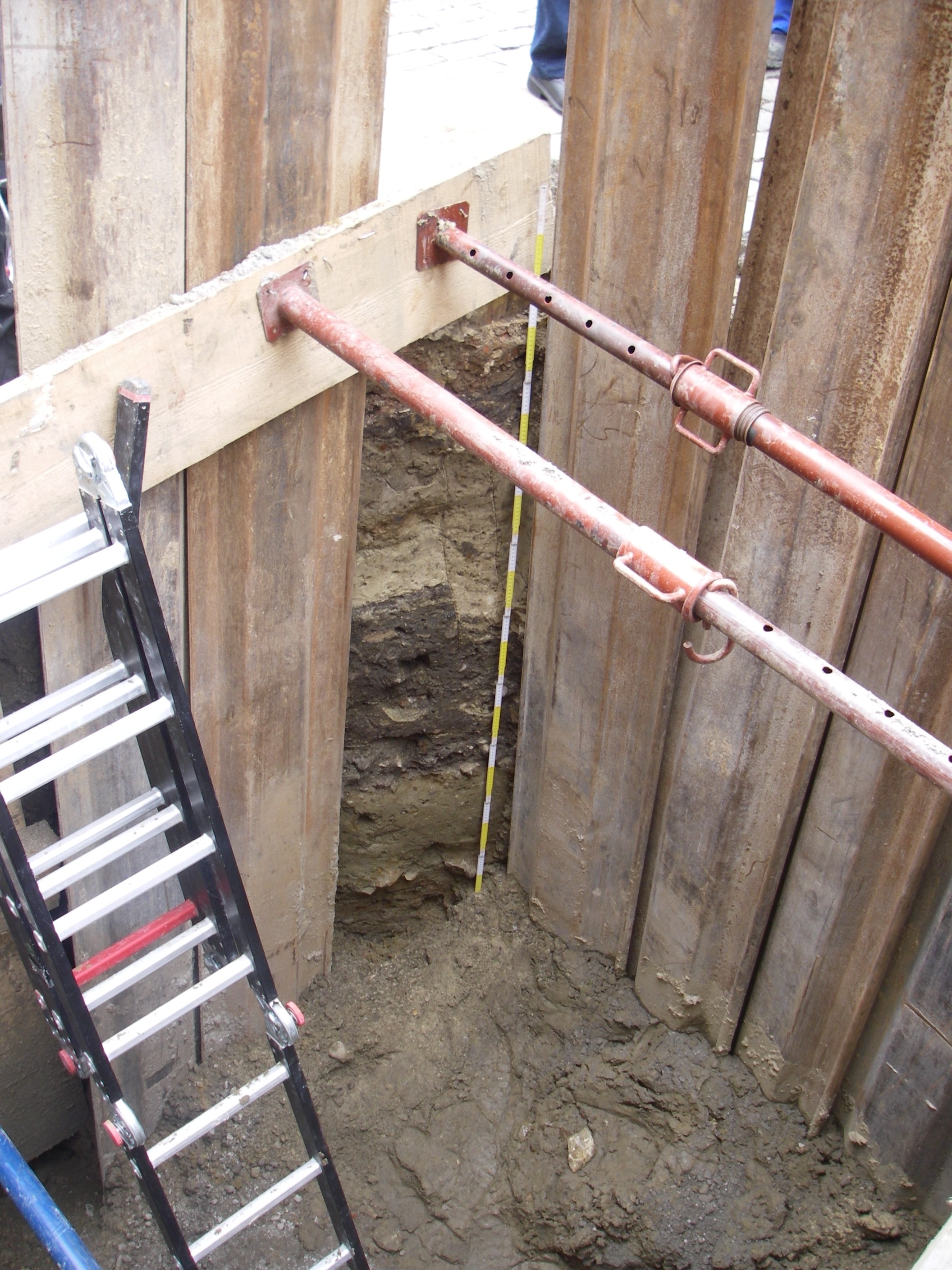
Archaeological interventions in an urban area vary considerably: in scope, they can range from assessments and archaeological follow up during construction works, to large-scale excavations (Figure 1); in size, they can vary from extremely small observation windows of a few tens of centimetres width (Figure 2), to whole neighbourhoods. Each type of intervention requires a specific approach to collect the necessary data. Moreover, urban archaeology is known for the presence of complex stratigraphies, resulting from many superimposed phases of human occupation within a restricted space. Lastly, accessibility is often an issue in urban settings, as trenches can be particularly small or deep.
In a densely urbanised area such as Brussels, there is a lot of pressure on the available space, which is often being reorganised. This results in a never-ending stream of construction works across the town, with the implication that choices need to be made about where to intervene. These choices rely from the start on the estimated archaeological and archaeoenvironmental potential. Another choice that needs to be made concerns the themes to investigate. Initially, the focus tended to be primarily upon the collection of environmental data from the selected sites, an understanding of complex site stratigraphies, and issues of taphonomy. While these remain valuable and necessary themes, progress in research and research techniques offers the potential to tackle new topics. This calls for a framework that provides sufficient flexibility to adapt to these new developments.
Depending on the disciplines involved, different scales of observation can be applied (e.g. regional surveys, field observations, microscopic observations). The type of data that can be obtained will also differ, for example, whereas phytoliths and macrobotanical data mainly documents the local vegetation, pollen informs primarily on regional vegetation.
The integration of results can be particularly challenging, as it needs to be conducted at different levels. A first level concerns the integration of the different botanical, geoarchaeological, anthropological and archaeozoological data. A second level consists of relating the different archaeo- and palaeoenvironmental data with the archaeological data at the unit/profile and site levels. At a third level, the environmental data is integrated into the broader picture at a neighbourhood/town scale, and combined with historical data.
Outreach can also be particularly challenging, as it needs to happen at different levels and address different stakeholders, including peers, public services and the wider audience.
This article therefore discusses how these challenges have been dealt with over the past few decades for the historical centre of Brussels, and how we can improve the framework further for the future.
The many challenges facing archaeo- and palaeoenvironmental research in Brussels required the development of a framework that enables scientists to address research questions at different scales (from microscopic to town level), but that is also sufficiently flexible to adapt to new lines of research and apply emerging analytical techniques and sampling methods (e.g. subsampling blocks, studying sediment DNA and lipids, applying optically stimulated luminescence).
The first step towards such an adapted and integrated framework was the development of a working protocol. The first published protocol (Devos and Fechner 2002) focused on the archaeopedological study of urban soils. However, the importance of confronting the results from different disciplines (archaeology, geoarchaeology, history, archaeobotany and archaeozoology) at the synthesis phase was already acknowledged. In 2007, the first interdisciplinary protocol (involving history, archaeology, archaeopedology and archaeobotany) was presented (Devos et al. 2007). This protocol included several steps: a desktop study; the collection of field data with a focus on taphonomy; sampling; laboratory studies; and a synthesis integrating environmental, archaeological and historical data.
Over time this general protocol has been further refined and adapted for emerging needs (Vrydaghs et al. 2015; Devos and Degraeve 2018). Additionally, a series of specific manuals has been created, including an archaeopedological field checklist (Devos 2003), a sampling manual for archaeoenvironmental studies (Devos in press a), and a sieving manual (Devos et al. 2012). These protocols and manuals have proven to be very suitable tools for addressing specific needs during excavations. However, following the exponentially growing number of large-scale interventions, the increasing number of disciplines involved and the diversification of demands by different stakeholders (including the research community, administration and wider audience), and the ever-evolving research, the need for an overarching framework to make clear and informed/well-founded choices became apparent. This resulted in defining a series of overarching research themes (Devos 2015; Devos and Degraeve 2018; and specifically for geoarchaeology, Devos et al. 2020).
The current protocol involves six steps.
This first step involves close collaboration between historians and archaeologists from the Brussels archaeological department (urban.brussels), and includes consulting archaeological atlases, historical maps and pictures. As the soil map for the historical centre is blank, other sources need to be utilised, including the Geotechnical Map (Dam 1975, 1977) and the Quaternary Geological Map (Schroyen 2003). Additionally, two databases are available grouping part of Brussels' environmental data:
Geoarchaeological field observations play a key role; a good knowledge of soils and sediments is mandatory in archaeology, but even more so for urban archaeology. As well as forming the matrix surrounding the artefacts and ecofacts, either protecting or degrading them, soils and sediments bear witness to ancient human activities and natural events. However, their study is often a delicate and complex exercise. The reasons for this are manifold:
In order to cope with this complexity, a set of basic rules is applied.
Taking into account the limited availability of some material (either because units are too shallow, or they could only be observed over a limited area), and the often severe time restraints, common sampling is favoured: this implies, for instance, that one overall sample will be utilised for different types of analysis. For example, large bulk samples will serve for both archaeozoological and macrobotanical analyses; block samples can be subsampled for phytoliths, diatoms and pollen.
To ensure the integrity of the samples and maximise their potential, sampling should be carried out either by, or in close collaboration with, the geoarchaeologist that has performed the taphonomical field study. The sampling is performed according to specific guidelines (Devos in press a). The sampling of funerary contexts is carried out by the physical anthropologist, again following specific guidelines (Quintelier 2015).
In order to answer the research questions raised during the desktop study and fieldwork, a selection of laboratory analyses will be carried out. To allow for an overarching synthesis of the results, these analyses should be carried out following a series of standard procedures. If no such standards exist, a new protocol will be developed, as was the case for the study of phytoliths in soil and sediment thin-sections (Vrydaghs and Devos 2018, 2020; Devos and Vrydaghs 2023). Other standards have been developed for the quantification of plant macro remains (e.g. Speleers 2023) and the study of sieving residues (Devos and Timmermans 2020). Importantly, before treating the samples, subsamples are taken and stored, thus permitting future supplementary analyses, as new research questions emerge or new techniques become available.
A critical step in the whole procedure is the integration of data. The results of the different archaeoenvironmental specialist studies are presented in specialist reports. These provide the starting point for further interdisciplinary discussions among the specialists, archaeologists and historians, aiming not only to synthesise at the structure/layer/site level, but also to realise overarching synthesis at the neighbourhood/ town level.
As a first step, the results are reported (as technical reports and at board meetings) on a regular basis to urban.brussels. This permits the Brussels' administration, urban archaeologists and environmental specialists to keep up to date with the latest developments.
To avoid the research ending up as grey literature, much attention is paid to disseminating the results to both the archaeological and respective environmental specialist communities, at both a local and international scale, through communications and publications. These can address both specific research topics and larger syntheses. Based on the impressive amount of research carried out over the last few decades, some larger syntheses have been made, both thematic as well as discipline specific (especially for geoarchaeology, see Devos et al. 2020; for macrobotanical remains, see Speleers and van der Valk 2017). Thematic syntheses include the early development of the town (Degraeve et al. 2010), the organisation of space (Devos et al. 2011a; Vannieuwenhuyze et al. 2012), ancient agricultural practices (Devos et al. 2011b; Vrydaghs et al. 2015), diet (Charruadas et al. 2017) and avifauna (Thys and Van Neer 2010).
A third element of outreach targets the wider audience. This is realised in a number of different ways:
Taking into account the vast potential of archaeoenvironmental studies in an urban setting, a series of choices need to be made. These choices are made jointly by the environmental and urban archaeologists of urban.brussels. Currently three main foci have been defined.
The first main focus of the research is systematic scrutiny of the urban stratigraphy by geoarchaeologists. Particular attention is paid to the potential preservation of the remains and taphonomical processes. On multiple occasions, this has already shown to be a crucial factor in optimising the potential of botanical and zoological data. One striking example has been its application to the study of phytoliths, enabling the distinction of plant remains related to manuring and soil disturbance from in situ cultivated remains to be made (Devos and Vrydaghs 2023).
Systematic geoarchaeological studies and the integration of data furnished by the other archaeoenvironmental specialists allow us to address a series of fundamental research questions (Devos et al. 2020), outlined below.
A second focus concerns the systematic collection of samples from a variety of contexts and structures, for subsequent archaeobotanical and archaeozoological study. Archaeobotanical studies include the study of plant macro- and microremains (including pollen and phytoliths), to address questions at both local and regional scales, but also to study sites where organic remains have been preserved, and sites where only inorganic remains and carbonised organic remains remain. Such studies allow us to address a series of vital issues in understanding the development of Brussels. The data not only informs us about the changing environment (Devos and Fechner 2002; Devos et al. 2017a), but is also a crucial asset for understanding aspects of the town's economy, including food production (Ervynck and Van Neer 2017), animal and human diet (Speleers et al. 2016; De Cupere et al. 2021), import of exotic plants (Speleers and van Der Valk 2017) and marine fish (Van Neer and Ervynck 2016), local artisanal practices such as textile dying (Speleers et al. forthcoming), hunting and fishing (De Cupere and Van Neer 2023). Furthermore, insights into social stratification can be gained (Speleers and van Der Valk 2017; De Cupere et al. 2021).
A third focus is the systematic recording and collection of human remains by the physical anthropologist. This guaranties the optimal collection of archaeoanthropological data during the excavation, and enables further detailed studies, including analyses of biological characteristics to study the health, lifestyle and socioeconomic background and organisation of the urban population (Quintelier 2009; Van de Vijver et al. 2024).
This brief overview of the research priorities and their resulting syntheses clearly shows that the research is firmly grounded within major current research axes in urban archaeology, such as the early development of towns, the organisation of urban space, urban economy, and social organisation.
The current research framework used for environmental studies in Brussels has proven to be particularly well-adapted for both interdisciplinary and multiscalar research, through which a diversity of research questions can be tackled.
The main challenge for the future is the development of an overarching database for all the archaeo- and palaeoenvironmental data from Brussels. Over the last few years, a series of specific databases have been developed (see above), but these are typically devoted to one discipline, nor have they been designed specifically for urban research. A first attempt at addressing this challenge will be the integration of all the data on the Senne river valley within the framework of an applied INNOVIRIS project (Vergouwen et al. 2024).
Other challenges include the integration of new scientific methods within the existing framework, and adjusting the framework to enable the incorporation of emerging research themes, such as the management of waste in an urban environment, and patterns of migration and trade.
Over the last few decades a framework has been developed for archaeoenvironmental studies in Brussels. Over time, it has been adapted to meet emerging needs. Today the protocol encompasses different steps: collecting desktop data, fieldwork, sampling, laboratory studies, synthesis and outreach. The framework has proven to be particularly well-suited to dealing with the research priorities defined by the different disciplines involved, thus enabling us to tackle major issues in urban environmental archaeology, including the early development of a town, the organisation of urban space, urban economy and social organisation. The main challenge for the future is the creation of an overarching database for all archaeo- and palaeoenvironmental research in Brussels.
The authors wish to thank the Brussels Capital Region for financing this research.
Internet Archaeology is an open access journal based in the Department of Archaeology, University of York. Except where otherwise noted, content from this work may be used under the terms of the Creative Commons Attribution 3.0 (CC BY) Unported licence, which permits unrestricted use, distribution, and reproduction in any medium, provided that attribution to the author(s), the title of the work, the Internet Archaeology journal and the relevant URL/DOI are given.
Terms and Conditions | Legal Statements | Privacy Policy | Cookies Policy | Citing Internet Archaeology
Internet Archaeology content is preserved for the long term with the Archaeology Data Service (ROR). Help sustain and support open access publication by donating to our Open Access Archaeology Fund.
 Home
Home