The nature of the site upon excavation was such that individual contexts were rarely identifiable except in areas which had experienced severe burning – elsewhere, the shallow, leached soil meant that colour differentiation was absent. Major differentiation in concentrations of stone was apparent, but otherwise structural evidence was extremely slight with few earth-fast timbers. The primary structural evidence consisted of artefacts – the motte-top excavation, consisting of a relatively small area of less than 22 metres by 27 metres, produced over 10,000 individually recorded artefacts. Some 3000 of these are fragments of burnt daub, many of which bear the impressions of wood grain on their flat surfaces, and a number of these are characterised by several flat surfaces, either stepped or at right-angles to each other. These are interpreted as being derived from horizontally planked timber-framed structures which were plastered with clay daub. In addition, nearly 700 nails of a variety of shapes and forms were recovered, many associated with fastening planking. Around 1200 fragments of lead were recovered, mostly tiny droplets of molten lead, but also small fragments of lead sheet and one or two large 'splats'. There were also over 500 pieces of medieval pottery – in a number of cases, pots discovered where they had been dropped and broken – plus the usual smattering of less common items – some loose change, some buckles and some ironwork, including knife blades and arrowheads, for example.
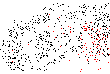
During excavation it became quite clear that the location of artefacts was significant, but only in the sense that locations of types of material became predictable and the suspicion developed that this was related to the presence of otherwise invisible structures. AutoCAD was used initially to generate artefact plots related to stone plans (for example, Figure 3) but it quickly became apparent that this was not as useful a means of visualisation as had been expected since the sheer quantity and density of data overwhelmed the plots. Instead, a GIS was used to investigate the artefact distributions in more detail (for example, see ; ). Contouring the data produced the reverse effect – depending on the interval chosen, patterning was too diffuse or too inexact to be meaningful in terms of the identification of structures and activity areas. In the end, rasterising the point data to form incidence matrices enabled clearer patterns and distinctions to be identified by generating artefact counts within 1 metre, 0.5 metre, 0.25 metre or smaller grid squares (for example, Figure ).
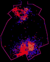
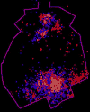
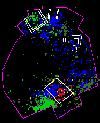
At a basic level, this provided a visualisation method at a range of resolutions which meant that the distributions were more amenable to examination and interpretation. The 3-D artefact data could also be used to construct cross-sections in the absence of identifiable context information which could then be used to test theories about building location and destruction (Figure ).
The end result is the identification of the location of at least one, and possibly two buildings, along with a probable cooking area, together with a greater understanding of the structural elements which did survive as identifiable contexts – the footings of a tower and bridge (Figure ).
URL: http://intarch.ac.uk/journal/issue8/huggett/jhexcavsc.html