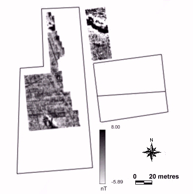
Fig. 6.15 & 6.17 Magnetometer survey, field 628 (Site 1/1)
Fig. 6.16 & 6.18 Interpretative plan of magnetometer survey, field 628 (Site 1/1)
(javascript must be enabled to view overlaying images)
A resistivity survey of four 20m by 20m grids was located to the west of the terraced field edge (Figs 6.11 - 6.12). The terrace wall itself was 2.5m high. A sub- rectangular area of high resistivity was located, around 25m by 12.5m [1]. This feature corresponded precisely with the distribution of tegula fragments from the field. A large linear feature running north-south across the survey area appears to represent a continuation of a line of terracing in the surrounding region [2].
A magnetometer survey was carried out in October 1997. The results were affected by considerable amounts of drift due to the hot, sunny weather conditions (Figs 6.13 - 6.14). Overall, the results demonstrated a large degree of disturbance across the field, with an irrigation drain cutting the survey area [1], and also bipolar readings distributed across it. Large magnetic anomalies in the field boundaries also obscured the edges of the survey. However, a possible curvilinear feature was present on the west side of the survey area [2].
This field was surveyed in September 1997, using a magnetometer and, by the standards of Portuguese fields, provided a relatively large area for interpretation (Figs 6.15 - 6.16). A number of large geological anomalies were noted [1, 2, 3], and the scarcity of features represented in the smaller of the two survey areas was attributed to the difference in height between the fields (see also Fields 629-631). A number of linear anomalies were noted, running across the survey area. In particular two positive linear features were noted, running parallel to one another in a north-south direction [4] approximately 1.5m wide, with a further feature orientated perpendicular to them [5]. It is possible that these represent earlier field boundaries, but it is conceivable that they mark an enclosure of some description. A curvilinear anomaly was noted in the south of the survey area [6]. A broad linear band of low negative readings runs in a south- south-east direction from a break in two linear anomalies [7]. This may indicate a track of some description, or may be associated with access routes to a ruined farm which was located to the east side of the field. Two other linear features were also noted in the north of the survey area [8].
Fig. 6.15 & 6.17 Magnetometer survey, field 628 (Site 1/1)
Fig. 6.16 & 6.18 Interpretative plan of magnetometer survey, field 628 (Site 1/1)
(javascript must be enabled to view overlaying images)
These fields are located to the east of field 628, further downslope on a different level of cultivation terrace. A smaller area of three 20m by 20m grid squares was surveyed with a magnetometer (Figs 6.17 - 6.18 - same as 6.15 & 6.16). The results were cut by a massive positive anomaly running north-west to south-east across the fields [3]. A number of sub-circular positive anomalies were also located to the north. All of the features appeared to be geological in nature, possibly caused by a fault running through the micaceous granite.
© Internet Archaeology
URL: http://intarch.ac.uk/journal/issue9/millett/geophys3.html
Last updated: Sat Dec 30 2000