This section examines certain aspects of the early development of Cricklade which can be inferred both from the new reassessment of the archaeological evidence discussed in the previous sections, from the topography of the town, and from other wider historical and archaeological evidence.
The defences
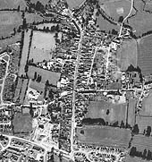
The positions of the previous excavations described by Radford, as well as those which took place in 1975, are here plotted for the first time on a large scale plan. It must be noted, however, that the precise alignment of the south defences and the position of the south gate are uncertain, since Wainwright's trench W.X cannot be more accurately positioned than to within about 6ft (2m) (Figure 6, SE quadrant). The slightly sinuous course of the line of the south defences is based on the observation of features (possibly one of the Saxon ditches) in aerial photographs (Figure 9). This overall plan makes possible an accurate assessment of the exact size of the defended enceinte, and clarifies the relationship between both the Saxon and the Norman defensive systems (Figure 7), as well as these defences and other elements of the topography.
Figure 9: Vertical aerial photograph of Cricklade, 1971
The general development and topography of the Saxon town and its defences have been described by Radford (1972, 97-100), with further discussion of various aspects by Loyn (1963) and Haslam (1981; 1984; 1986). Some details, however, require closer examination. It will be observed that all sides of the defences except the north are very slightly convex in shape. The line of the north defences is asymmetrical, but the fact that it follows in general the 80m contour, as the defences also do on the east side, implies that their exact course was determined by the limits of the flood plain of the Thames.
The lengths of the defences can also now be accurately measured for the first time (Haslam 1986). These are in all cases shorter than those estimated by Radford (1972, 97-9), who gives a total of 2280 yards along the outer edge of the wall (or along the original front of the bank) as against the length of 2235 yards determined from the plan. This reduces the discrepancy noted by Radford between the length implied by the Burghal Hidage (1500 hides, covering 2046 yards) and the actual length. This discrepancy is of course reduced even further if the length taken is that around the inner edge of the bank (i.e. the intra-mural walkway). These defences enclose an area of 25.41 hectares (62.38 acres) measured inside the inner edge of the bank. This compares with an area of 80 acres (32.06 hectares) given by Radford (1970, 88), and 29.2 hectares (71.68 acres) by Biddle (1976a, 126), both of them considerable over-estimates
One aspect which emerges from the plan of the Saxon defences is the regularity of their layout. From measurements taken from the corners of the intra-mural walkway (Haslam 1986), it can be shown that the defences were laid out on the basis of a perfect square with sides of 96 poles in length, taking the 'standard' pole as 16.5ft. This is six times the 16 pole module suggested by Crummy (1979) as being used in the layout of other Saxon burhs. The southern defences were extended eastwards by about 8 poles (132ft), to place the eastern defences along the edge of the flood plain of the river, marked now by the 80m OD contour (Figure 2). This also provides some confirmation of the hypothesis advanced independently from the archaeological evidence that the intra-mural walkway was the first element in the defences to have been constructed, acting as the initial grid from which the rest of the defences, as well as the gates and streets, were laid out on the ground. This general aspect is discussed elsewhere (Haslam 1986).
The streets
The overall model postulated for Winchester and other places by Biddle and Hill (1971) for the contemporaneity of layout of both internal streets and defences has been extended by the realisation that the intra-mural or wall street is a vital connecting link between the two systems (e.g. Biddle 1976a, 129-30). The demonstration that an intra-mural walkway formed an integral part of the defensive system of Cricklade carries the implication, therefore, that the street system as a whole, as well as the spaces definded by these streets, were 'a deliberate expression of the organisation and apportionment of land for permanent settlement' (Biddle and Hill 1971, 83). As has been generally inferred (Biddle and Hill 1971; Haslam 1984a, 110) the two surviving streets in the north-east quadrant of the fortress at Cricklade are likely to perpetuate the lines of streets whose layout is probably contemporary with that of the defences.
From the fact that the intra-mural walkway failed to survive in use beyond the middle of the 10th century at the latest, in contrast to the wall street at Winchester, it could be inferred that the original street grid at Cricklade was possibly rather more extensive than is indicated by the surviving streets. It is probable, therefore, that a similar pattern to that in the north-east quadrant existed in the south-east, a hypothesis strengthened by the presence of stumps of streets opposite Thames Street and Horsefair Lane on the south side of Calcutt Street shown on early town plans (Figure 10). The position of these are aligned with soil marks and hedge lines shown on aerial photographs Figure 9. It is unlikely that a similar pattern extended over the south-west quadrant, which was the site of the church and Parsonage Farm, especially since the 'street' postulated by Radford in the south-west corner (1972, 83, 98, 103 and fig. 12) is shown (section 1) to be an illusion. In view of the absence of any signs of Saxon or medieval occupation in the extensive excavations in the north-west quadrant in 1975, it is likely that this area within the burh has always been open.
Figure 10: MS plan of Cricklade, c. 1780
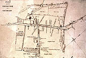
Another feature which can be argued as being a primary component of the layout of the original fortress in the 9th century is a possible open market area on the northern side of the church. The line of the western end of Bath Road, when extended eastwards past the churchyard, meets a small lane leading into the High Street, while Bath Road itself swings northwards. The space in between these two streets, occupied now with properties with less regular boundaries than those on either side, can be interpreted as being a former open market area. As such it possibly included the northern part of the present churchyard as well as space to the north of Bath Road (see Figure 10). The siting of a market area in this position at Cricklade could have combined the advantages offered by the natural topography, ease of access from all directions, and proximity to the church. This layout has no exact parallels in other late Saxon fortresses, in which, as at Winchester, the main streets generally seem to have acted as market-places (Biddle 1976c, 285-6). A parallel can, however, perhaps be recognised at Winchester, where a market area inside the north gate, deduced from topographical evidence, appears likely to have been a component of the original layout of the burh (Biddle 1976c, 282, n.1). One possibility, therefore (discussed below), is that this perpetuates a feature which was part of the 'pre-burh' topography, which was associated with a settlement which had developed around the church by the 9th century.
Conclusion
The combination of these topographical features and the wider settlement relationships of Cricklade allows two alternative models for its early development to be postulated. The first alternative would suggest that the Roman centre, sited at a crossing of the river by a major Roman road, became a high-status middle Saxon settlement with special royal connections, performing significant central-place functions at the boundary of two kingdoms - the Hwicce (later the Mercians) and the West Saxons. If, as is suggested elsewhere (Thomson 1961, 65; Haslam 1984a, 106), the church was an early minster, the occurrence of the central 'market area' pointed out above can be explained by the hypothesis that it was part of a complex of features which appears to have been characteristic of the layout of some other royal settlements in Wiltshire and elsewhere of the middle Saxon period (Haslam 1984a, 136-9, fig. 57; Blair 1988, 40-50). The main elements of this royal settlement would on this interpretation have been a minster church, an open market area and a royal palace enclosure, forming a close-knit complex on a topographically distinctive site and approached by early routeways. Against this hypothesis is the fact that there is no evidence of post-Roman settlement at Cricklade dateable to before the layout of the late Saxon defences (apart from a very few middle Saxon pottery sherds), and no evidence that the church at Cricklade was a minster of the conversion period. The middle Saxon pottery found at various times at Cricklade is insufficient to allow the certain inference that there was a settlement at Cricklade of any significance in the middle Saxon period.
Concentrations of material covering a wide time-span have been noted at another early crossing place of the river at Kempsford, 7km (4 miles) to the east - named aet cynemaeres forda in AD 800 (Smith 1956, 38). These finds are from the Iron Age (coins), Roman period (many finds of pottery, bronzes and building materials, early Saxon period (burial with worked metal, bronze and glass), and the late Saxon period (Viking spearhead, axehead and adze found in the river). There are also many undated features such as trackways, circles, etc., concentrated around the ford. This evidence demonstrates the existence of a customary and important crossing-place of the Thames of long standing, at a place considered to be the boundary between Wessex and Mercia. It is possible, therefore, that this crossing-place, used in the pre-Roman period, was superseded by a new crossing at Cricklade established as a result of the building of a new military road and settlement by the Romans, and that in the subsequent two millennia both acted as focal points for human movement and settlement.
The second alternative model would suggest that any settlement on the site of Cricklade before the construction of the fortress was nothing more than a small 'village' - if indeed it existed at all - around the river crossing. Radford (1972, 96-7) raises the possibility of the existence of a settlement at Cricklade (though no more than a 'hamlet') before the establishment of the late 9th century fortress. However, the existence of 'extensive and prolonged ploughing' sealed underneath the bank which he has adduced in evidence for this must now be discounted (see period 0-1, Part 2). The spatial relationship of this to its Roman predecessor would in this case have been the result not of functional continuity but rather of a geographically determined accident. There are further doubts as to whether the Roman centre was of sufficient importance in the historic landscape to have survived as a significant centre into the middle Saxon period. The status of Cricklade church as a primary minster of the conversion period cannot be demonstrated unequivocally and, as has been pointed out elsewhere, the evidence of any early royal connections is rather less evident than in the cases of other similar places such as Wareham and Wallingford (Hill 1978, 217-22).
A somewhat stronger case can in fact be made for the existence of an earlier and probably more significant settlement focus in the period before the late 9th century at Purton, not far to the south (Haslam 1984a, 105, fig. 43). This was the site of a Roman villa and pottery industry, as well as having pagan Saxon burials near the church (ibid. 106). Its early importance is furthermore shown by the fact that it was the subject of grants made and confirmed by various kings in the 7th, 8th and 9th centuries to Malmesbury Abbey (ibid. 141, n.21). An early minster, established in the late 7th or early 8th century by the Abbey, possibly by Aldhelm himself, as part of its Christianising activities (as was the case with others at, for instance, Bradford-on-Avon and Frome), is therefore perhaps more likely to have existed at Purton than at Cricklade.
If this is so, the initial gift of Purton (which must have included the present site and parish of Cricklade) by King Cadwalla of Wessex to Malmesbury in 688 (Finberg 1964, 69, no. 185) probably had a deeper significance. I have suggested that one of the principal interests of the West Saxon kings in Malmesbury at this period was that it could act as a stabilising influence (if not an actual defensive outpost), situated as it was on the borders of Wessex with Mercia and adjacent to the Roman Fosse Way which ran from Cirencester to Bath. It therefore seems likely that this gift of Purton to the Abbey was made with the same intention: that this strategically important area on the boundary of Mercia and Wessex, where the two were connected by Ermin Street, should be secured in safe hands. The fact that Offa of Mercia went to the trouble to take this estate back from Malmesbury (Finberg 1964, 72, no. 196) implies that at that time it had some over-riding value which possibly reflected its perceived strategic significance to Mercia.
This second alternative model fits in with arguments put forward here, and elsewhere (Haslam, forthcoming), that the fortress at Cricklade was one of the key elements in a crash programme of fortress-building instigated by King Alfred in the years 878-9, which was designed to act as a defence of Wessex against Viking armies stationed during these years in both Cirencester (only a short distance away along Ermin Street) and Fulham. The force of these arguments suggests that the siting of the fortress of Cricklade owes more to its position in guarding the crossing of the Thames by Ermin Street (along which Guthrum's army could very easily have penetrated Wessex) than to the existence there of an earlier settlement, whether major or minor. The church at Cricklade can in this scenario be seen as one of a common class of new urban minsters provided for the inhabitants of the fortress by the royal founder (Haslam 1988). It would also fit with this model to see the 'market area' to the north of the church as being merely a widened street integral with the original layout, rather than an earlier topographical feature incorporated into it. On this interpretation the fortress is likely to have been built on a virtually new site, though perhaps incorporating pre-existing routeways - from the south-west from Malmesbury and from the south from Purton - heading towards the river crossing.
© Internet Archaeology
URL: http://intarch.ac.uk/journal/issue14/1/earlydevel.htm
Last updated: Mon Jul 7 2003