The history and development of this system of records has already been fully described in several published sources (e.g. Burrow 1984; Lang 1992; RCHME 1993a; Robinson 2000). A brief account will be sufficient here, therefore, to provide the context for the development of SMRs in England.
The systematic creation of inventories of archaeological and historic monuments can be traced back to the creation of the Royal Commission on the Historical Monuments of England (RCHME) in 1908. The Royal Warrant instructed this Commission to
'make an inventory of the Ancient and Historical Monuments and Constructions connected with or illustrative of the contemporary culture, civilization and conditions of life of the people in England... from the earliest times to the year 1700, and to specify those which seem most worthy of preservation.'
The RCHME produced and published inventories for just over half the English counties, but in the late 1970s, there was a major shift of policy after it became clear that this task would take many decades, if not centuries, to be achieved.
In the meantime, the mapping of antiquities on Ordnance Survey (OS) maps had resulted in the development of a card index system (Fig. 1), which was to become an essential source of information for the subsequent development of SMRs. This card system was maintained and revised because the OS maps were regularly revised. Antiquities were documented to a high standard as a justification for their depiction on maps. The cards were maintained by the Archaeology Division of the OS, which was transferred to the RCHME in 1983. The record cards themselves formed the core of the National Archaeological Record, of which more later. At a local level, annotated maps and card indexes were often maintained by the OS's correspondents such as (in Essex) J.G.S. Brinson and M.R. Hull at Colchester.
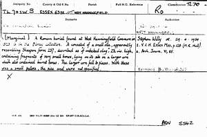
Figure 1: Ordnance Survey Record Card
In the 1960s, the increasing recognition of the threats posed to archaeological sites from development, resulted in the Walsh Report into the protection of field monuments (1969), whose recommendations included:
'A consolidated record of all known field monuments should be held by the County Planning Authorities so that they may be aware of all such monuments in their areas.
'County Councils which have not already done so should consider whether adequate professional archaeological assistance is available to them and should examine whether the appointment of an archaeological officer on a full or part-time basis is called for in their areas.'
Although these recommendations were immediately implemented, local SMRs began to emerge from the late 1960s, beginning with Oxfordshire (Benson 1974). A major impetus to the evolution of the network of SMRs came in the 1980s, with the development of archaeological rescue units, and project funding:
'In 1981-82, DOE attitudes towards the local service were revised with the realisation that a systematic and rational approach to preservation demanded a foundation of Sites and Monuments Records developed to a consistent and minimum level of completeness. DOE grants began to flow back to SMRs and field survey work.'
(Baker 1983, 148).
Department of the Environment (DoE) and, later, English Heritage, funding provided the basis for the recasting and computerisation of SMRs. Use of the form for recording Scheduled Monuments, the AM107, provided an initial data standard. English Heritage also provided software, in the form of the SUPERFILE package, which was adopted by just over half of the county SMRs.
The development of a national network was not uniform, but each English County Council, and some Districts and Unitary authorities, now has a Sites and Monuments Record, in almost all cases under the direction of a qualified archaeological officer. In some areas, for example the former metropolitan counties, joint services have been created, operated by a number of authorities. The exact locations of the SMRs vary — while many are in Planning Departments, others are in museums and Property Departments. There are also other, more localised and specialised SMRs, for some important historic towns such as York and Colchester, created as a result of English Heritage's Urban Archaeological Databases (UADs) initiative. These are maintained by District Councils or Archaeological Trusts but, where appropriate, they are normally linked to the county SMR.
The unsystematic nature of SMR development, resulting from both local and national initiatives, and local government restructuring, has resulted in a fragmented situation. Over 90 SMRs now exist, of varying size and resources.
Despite the public funding which went into the creation of SMRs, and the location of the majority of them in local government, there is little statutory basis for their maintenance. The 1988 Town and Country Planning Act General Development Order defined an archaeological site as one 'held within a Sites and Monuments Record maintained by a County Council'. This definition was revised in the Town and Country Planning Act (General Permitted Development Order) 1995 to:
'Land which is ...... or which is within a site registered in any record adopted by resolution by a county council and known as a County Sites and Monuments Record.'
The importance of SMRs was given further recognition in 1990 when Planning Policy Guidance Note 16 (PPG16),
dealing with the treatment of archaeological remains in the planning
system, was issued by the Department of the Environment (DoE 1990).
However, the lack of statutory support can, potentially, have negative
effects on the staffing and funding of SMRs.
© Internet Archaeology
URL: http://intarch.ac.uk/journal/issue15/3/pg1.html
Last updated: Wed Jan 28 2004