The GIS analysis presented here interprets the implications of an application of particular definitions of past human practice (economic choices) through time. The resulting spatial patterns of land use are linked in different ways to the human action that created these patterns while considering specifically its diachronic nature. This article particularly aims at highlighting the possibility of discussing taskscapes related to economic behaviour (2.1 and 2.2).
The diachronic GIS modelling procedure was chosen to represent the environmental impacts of economic decisions, involving a variety of tasks, including farming (growing crops), herding (tending animals) and foraging (hunting and gathering a large variety of wild resources), in a chosen area. The proposed research area is situated within southern Calabria. The total surface is approximately 628 square km, and includes a large variety of environmental niches, from coastal plains to upland mountains (see Fig. 2). The time period investigated spans the Neolithic, dating from the 6th millennium to the middle of the 4th millennium cal. BC (Skeates 1994, 270-77). The nature, meaning and development of Neolithic land use have received particular focus because of the dynamic characteristics of this period, which saw the introduction of new and changing relationships between people and their surroundings.
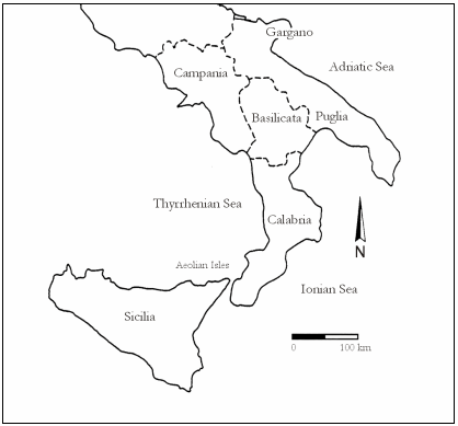
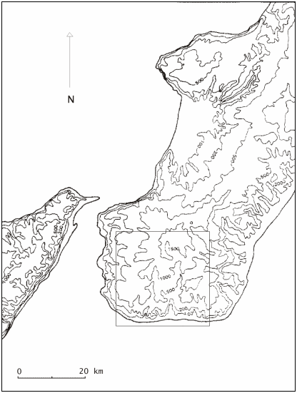
Figure 2 a and b: Location of Calabria and location of the study area within Calabria (southern Italy) (2a: after Pluciennik 1997, 2b: after Robb 1998)
The GIS model was based upon relevant data bought from the Italian Military Institute (Istituto Geografico Militare or IGM: topographic and geological maps), upon archaeological information from field survey site distributions, part of the Bova Marina Archaeological Project (BMAP, Dr J. Robb, University of Cambridge), and upon other local archaeological and cultural information. Environmental criteria were modelled using current and historical Mediterranean geographical and ecological information and comparative studies from Mediterranean prehistory (e.g. Barker 1981a; 1985a; 1985b). Parameters of yield and accessibility (cost) were based upon Neolithic land-use studies elsewhere in Europe (Gregg 1988) and upon ethnographic material (e.g. Lee 1979; Kelly 1995). Annual visits to the terrain during the summers of 1999 to 2003 helped to establish a better understanding of the studied environment for the assessment of environmental niches, yield values and accessibility scores.
Firstly, on the basis of elevation, slope and river proximity parameters (from IGM), ecological and archaeological literature (e.g. Parra et al. 1998; Robb 1998, 8-9) and local field observations, an environmental niches map of the study area was created (Fig. 3). Seven environmental niches were identified, representing a set of current ecological zones within the study area. This map was used as the potential Neolithic environment people lived in. The different zones are coastal plain (beach and dunes), river channels, lowland plateaus and hills, highland plateaus and hills, and cliffs.
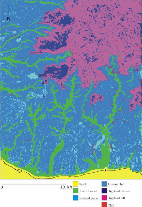
Figure 3: Environmental niches map of the study area
Secondly, to visualise the effects of a range of economic choices within this environment, I introduced two types of values, one to enable a possible 'translation' of a physical environment into an economic landscape, the other to evaluate it: yield and cost.
© Internet Archaeology
URL: http://intarch.ac.uk/journal/issue16/5/3.1.html
Last updated: Thur Nov 11 2004