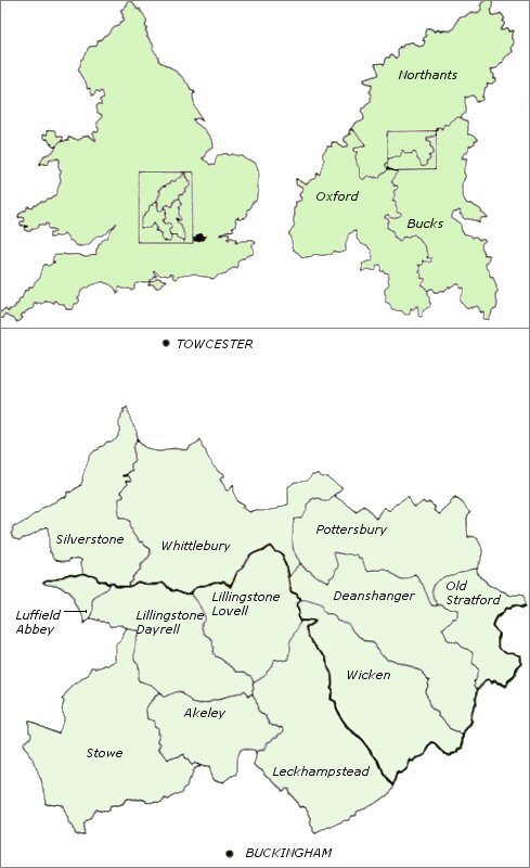
Map of study area, based on image WP18 from digital archive.
Introduction | Exploring Medieval Village Territories | The Evolution of Post-medieval Village Territories | The Creation of Village Territories | The Development of Medieval Village Territories | Late Medieval Village Territories | Conclusions
By c.1300, compact or nucleated villages had become the dominant form of settlement across large parts of England. In particular they occupied a central swathe of countryside running from Somerset and Dorset in the south-west, through the Midlands, to Yorkshire and Northumbria in the north-east (Roberts and Wrathmell 2000). To the north and west, settlement was characterised by smaller hamlets and individual farmsteads, while in the south-east a more mixed pattern had emerged, where villages, hamlets and farms successfully co-existed. How and why this regional variation came to develop, from what origins it sprang and when, all remain a matter of considerable debate (e.g. Lewis et al. 1997; Roberts and Wrathmell 2002; Taylor 2002; Williamson 2003). In part, the uncertainties that continue to surround the subject stem from an imbalance in scholarly approach. Villages have held a special fascination for historians, geographers and archaeologists for more than a century (Williamson 2003, 1-27 passim). Hamlets and farmsteads have received far less attention. Consequently, it has been 'village country', rather than the 'land of hamlets' (Maitland 1897) where most attention has been concentrated. This is a situation which is beginning to be redressed as more work is undertaken outside the so-called Central Province (e.g. Dyer 2002a), and within it, as atypical or hybrid sub-regions have become the focus of detailed exploration (e.g. Brown and Taylor 1989; Dyer 2002b; Fox 2000; Jones and Page 2003; Taylor 1995).
Just as medieval settlement plans have continued to exert an influence upon modern forms, so earlier agricultural economies and variations of farming systems found within them have left indelible marks upon the wider landscape, lending it physical structure which has further emphasised regional variation. Observable differences in the shape, size, regularity or irregularity of fields, the presence or absence of woodland or whether it was disposed in large blocks or small isolated stands, together with the network of roads and tracks which linked these to the settlements from which the land was worked, form the basis of an alternative reading of the countryside, divided between the 'planned' and the 'ancient' (Rackham 1986, 4-5). The geographical coincidence of areas defined by this method of categorisation and those areas exhibiting different settlement forms strongly suggests that the two were closely linked, either throughout or at least at critical stages of their development. Simple distinctions are easily identified, such as that which exists between the uplands, pastoralism and dispersed hamlets and farmsteads, and the lowlands with economies dominated by arable cultivation, and more nucleated settlement forms (e.g. Beverley Smith 1971). But inevitably such generalisations mask important local distinctions. In the English and Welsh lowlands, for example, open field farming was adopted by some medieval communities and not others; if the distribution of nucleated villages correlates closely with that of open fields, the latter might on occasion also be worked from more dispersed settlement patterns; and how the management of open fields might have many variants (Baker and Butlin 1973).
The test bed for the ideas which are presented here is a block of countryside, 100km square in extent, straddling the county boundary between Northamptonshire and Buckinghamshire, lying deep within 'village country' (Lewis and Mitchell-Fox 1993). This was an area in the middle ages of both nucleated and dispersed settlement, open field farming and royal forest. Now encompassed within twelve civil parishes, this area has been used to examine the relationship that existed between individual settlements, or groups of confederated settlements, and their arable fields, pasture, meadow and woodland. What is offered here is not the total history of this landscape, more extensive treatment of which can be found elsewhere (Jones and Page forthcoming).Rather this article concentrates upon the formative medieval centuries over which villages began to form in this area and to assume their mature plans, a period which also saw radical changes in the ways that the land was carved up administratively and reorganised economically. The result was the division of the landscape into what we have termed villagescapes.
Map of study area, based on image WP18 from digital archive.
© Internet Archaeology
URL: http://intarch.ac.uk/journal/issue19/5/1.1.cfm
Last updated: Mon Sep 4 2006