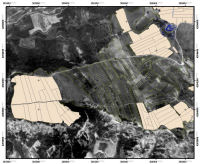
Figure 5: A view of the Upper Plateau and tracts.
The methodology of the urban survey is ultimately dictated by the ancient urban area, which in this case is conveniently located entirely on top of the plateau. The lower Archaic and Classical city, which was destroyed by Poliokretes, is under the modern city of Kiato and therefore un-surveyable. Since the area of the plateau is rather large, three zones were defined based on topography as opposed to potential archaeological factors. Further division of the three zones into tracts is based on current land usage and field boundaries. This maintains contextual information over the specific areas within the three zones. Such partitioning provides control over the contents of the field surface since agricultural and land-use disturbances vary from field to field and therefore affect the archaeological record.
The smallest unit within the survey is that of the 20 x 20 metre square. Owing to imperfections in the layout and orientations of the fields, this size is not always possible so smaller squares do exist as well as trapezoidal and triangular 'squares'. The cut-off size for squares is one hundred square metres, so any smaller squares get amalgamated with an appropriate neighbour in the tract. This methodology provides a systematic study of the urban area of Sikyon. The archaeological information acquired through this intensive survey is comprehensive while also allowing for flexibility in how particular tracts are addressed.
The primary aims of the in-field recording are validity, consistency and comparability (Dan Stewart, pers. comm. July 2006), which are required for the later analysis and interpretation of the data. Similar to excavation, survey fundamentally alters archaeological material, requiring data collection and recording to be systematic. Teams of five field-walkers, equally spaced, walk in straight lines over a square identifying material evidence of past human usage. Pottery sherds, roof tiles, small finds, and architectural features are all recorded on various recording forms while in the field. On average, 50% coverage of a square is achieved through this method but this is acceptable as the time and energy required to record every single artefact would be excessive.
The most common type of collection is the 'diagnostic only', in which the field-walkers simply count the number of pottery sherds and roof tiles which they come across. Diagnostic pieces and other small finds are collected and brought back to be processed by specialists to acquire more specific dating and usage information. 'Total collection', in which all pottery sherds are collected by the field-walkers, commonly along two straight lines crossing each other at the middle of the square, is carried out every fifth square. All pottery sherds, diagnostic or otherwise, are then taken back to the apothiki (storage room) to be processed. For a more thorough review of these aspects of the project please consult Lolos et al. 2008.
© Internet Archaeology/Author(s)
URL: http://intarch.ac.uk/journal/issue23/5/2.2.html
Last updated: Tue Mar 25 2008