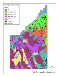
Figure 3: Distribution of findspots and soils in the Larinum case study area.
Once the data have been digitised, further visualisation and more formal analysis can proceed. A useful approach is to re-evaluate original survey aims. For example, the Biferno valley survey was conducted during the 1970s and published during the 1990s (Barker 1995a; 1995b); hence, as with many large projects, significant theoretical and methodological advances had been made between the survey's initiation and its publication. The surveyors' original research questions concerned processual interests such as the relationship between settlement and environmental resources. The final report reconceived these research questions within an Annales framework placing more emphasis on human agency, particularly for historical periods (see Barker 1991).
It has been suggested that the time lapse between large surveys commenced in the 1970s and their analysis and publication today can lead to a situation in which GIS is used in the uncritical service of outdated theoretical perspectives (Gillings 2001, 111). However, GIS offers a tool not simply to realise or repeat original research questions, but also to re-evaluate them. Research aims have significant influence on the data collected through the methodologies used. Consideration of original survey aims enhances understanding of the character of results. Such analysis should not be the sole aim of a GIS approach to legacy data, but can form an informative part of it.
The Biferno valley survey was particularly concerned with the relationship between people and environment. An interim discussion (Barker et al. 1978, 45) argued that arable cultivation was limited to the lighter, free-draining sandy soils of the ridges around the town of Larinum and on the edge of the river plain (i.e. mixed sands/clays, limestone). The heavier, silt soils of the plain itself (i.e. alluvium) were considered to be more difficult to cultivate and, as in more recent times, were devoted to pastoral exploitation. Consequently, sites were located on the higher, lighter soils; artefact scatters on the plain were argued to represent annual transhumance camps (Barker et al. 1978, 48). Re-assessment of the distribution of findspots in relation to soils would be an extremely time-consuming exercise using the paper gazetteer; moreover, the report provides no quantification of the extent of each soil type and therefore the significance of any patterning could not be assessed. Such analysis is a simple matter to address via GIS.
Table 3: Summary of soil types within Larinum case study area (area/percentage) and summary of sampling by the Biferno valley survey (area/percentage of total)
| Soils | Total case study area | BVS sample area | ||
|---|---|---|---|---|
| Km² | % | Km² | % sample | |
| Alluvial (1) | 15.88 | 12.35 | 14.53 | 91.46 |
| Alluvial (2) | 11.64 | 9.05 | 2.65 | 22.80 |
| Clays | 14.38 | 11.18 | 3.72 | 25.88 |
| Limestone | 41.44 | 32.22 | 15.30 | 36.93 |
| Mixed sand/clays (1) | 14.11 | 10.97 | 12.29 | 87.11 |
| Mixed sand/clays (2) | 19.59 | 15.23 | 12.10 | 61.76 |
| Mixed sand/clays (3) | 11.38 | 8.85 | 2.45 | 21.52 |
| Total | 128.61 | 100.00 | 63.04 | - |
Table 4: Chi-squared test results for Biferno valley survey findspots and soil types in the Larinum case study area (df = 6; [p] = 0.01)
| Soils | Biferno valley survey | ||
|---|---|---|---|
| Obs | Expected | Calc x² | |
| Alluvial (1) (Pleistocene) | 71 | 41.96 | 20.119 |
| Alluvial (2) (Recent) | 2 | 7.65 | 4.174 |
| Clays | 7 | 10.74 | 1.302 |
| Limestone | 31 | 44.17 | 3.927 |
| Mixed sand/clays (1) | 29 | 35.48 | 1.184 |
| Mixed sand/clays (2) | 40 | 34.93 | 0.735 |
| Mixed sand/clays (3) | 2 | 7.07 | 3.639 |
| Total/mean | 182 | 182 | 35.080 |
Figure 3: Distribution of findspots and soils in the Larinum case study area.
Within the case study area, the outline of each survey was overlaid on the soil map to establish the extent of each soil class sampled (Table 3). The number of findspots located on each soil type was then derived (Figure 3). A one-sample chi-squared test was used to assess whether the number of observed findspots per soil type was significantly higher than expected. The results confirm a significant relationship (Table 4); there are almost double the number of expected findspots on the difficult-to-work (Pleistocene) alluvial terraces. An association between the number of sites and soil type is not incompatible with the original interpretation, but the unexpected concentration of findspots on the supposedly difficult-to-use soils gives a different emphasis; in simple quantitative terms, this was a favoured area. This association can be combined with other observations. Many of these findspots are extensive, low density scatters usually of a single period, with evidence for pottery but not tile. Barker et al. (1978) argue that these represent pastoralists' camps, but would these have been so widely-dispersed if this were a wooded and poorly drained (even malarial) landscape? An alternative interpretation might be that these scatters derive from manuring as part of the long-term cultivation of the plain (Bintliff and Snodgrass 1985); the percentages of (datable) findspots which make use of this soil type are broadly stable from the Iron Age through to the Roman period (Figure 4) suggesting that the exploitation of this resource waxed and waned with broader shifts in settlement numbers, rather than the introduction of new technologies or subsistence strategies to overcome environmentally-determined constraints. Assessment of the comparative abrasion of material from these findspots might prove informative; sherds derived from manuring might be significantly more abraded than sherds derived from stratigraphic contexts (in the Biferno valley, many sites were fieldwalked soon after the introduction of deep ploughing in the region, reducing the abrasion of material recently derived from stratigraphic contexts).
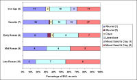
Figure 4: Graph of findspots in relation to soils in the Larinum case study area by period.
Simple GIS overlay functions allow a quick evaluation of the survey's original aims, results and interpretations. In this case, it is possible to corroborate a relationship between soils and settlement, but the distribution of settlement suggests a different emphasis. Interpretation might be revised to focus less on the environmental constraints on agricultural exploitation. For example, the location of villas might be determined not by the lighter soils above the plain, but by the elevated topography which could provide appropriate panoramic views for elite rural retreats. The relationship between soils, topography and viewsheds might be formally investigated via further GIS work.
© Internet Archaeology/Author(s)
URL: http://intarch.ac.uk/journal/issue24/2/3.2.html
Last updated: Mon Jun 30 2008