Department of Archaeology, Durham University, South Road, Durham DH1 3LE, UK Email: [email protected]
Cite this as: Witcher, R. 2008 (Re)surveying Mediterranean Rural Landscapes: GIS and Legacy Survey Data, Internet Archaeology 24. https://doi.org/10.11141/ia.24.2
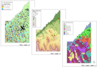
Legacy data have always been important for Mediterranean archaeologists. Over the past decade, one specific category of legacy data, that deriving from regional survey, has become particularly important. Not only has the scale of research questions become larger (requiring greater reliance on others' data), but the surface archaeological record is deteriorating (diminishing the ability to recover good data). The legacy data from many individual surveys have now been subject to digitisation and GIS analysis, successfully redeploying data collected for one purpose within new theoretical and interpretive frameworks. However, a key research focus is now comparative survey - using the results of many different Mediterranean surveys side-by-side to identify regional variability in settlement organisation, economy and demography. In order to overcome the significant methodological differences between these surveys, attention has focused on the documentation of metadata. Yet, many legacy data lack vital information about their creation and hence how they might be (re)interpreted and compared. GIS has been advanced as an environment in which to contain, order and analyse the data necessary for comparative survey. However, there is a danger that the technology will facilitate inappropriate use of these datasets in a way that fails to acknowledge and understand the very real differences between them. Here, emphasis is placed upon the use of GIS as a space for exploratory data analysis: a process that encompasses and emphasises the integral processes of digitisation, visualisation and simple analysis for the characterisation of datasets in order to derive an alternative form of metadata. Particular emphasis is placed upon the interaction of past human behaviour (e.g. in the Roman period) and archaeological recovery (i.e. the behaviour of archaeologists in the present, or recent past); these two sets of 'social action' combine to create distinctive archaeological datasets. This search for 'contextual' metadata within individual legacy survey datasets supplements more 'formal' metadata and facilitates both interpretation of individual surveys and comparison between them. Case studies from Italy are used to illustrate the kind of iterative and incremental approach to legacy survey data advocated.
Thanks to Pim Allison for the invitation to contribute and to Alice Hiley for her assistance during the writing of this article.
Go to Table of Contents
© Internet Archaeology/Author(s)
URL: http://intarch.ac.uk/journal/issue24/witcher_index.html
Last updated: Mon Jun 30 2008