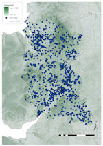
Figure 14: Distribution of finds in west central England against topographic base map
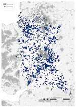
Figure 15: Distribution of finds in west central England against constraints base map
Figure 16: Chart showing PAS finds in west central England by period
Figure 14: Distribution of finds in west central England against topographic base map
Figure 15: Distribution of finds in west central England against constraints base map
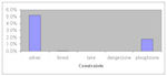
Figure 16: Chart showing PAS finds in west central England by period
Topographically, western central England (Fig. 14) comprises mostly low-lying ground (below 100m OD) and four major river systems: the Severn/Avon draining to the south-west; the Thames to the south-east; the Trent draining north-east into the Wash; and the Dee/Gowy draining into the Irish Sea. Bounding these, the Pennines stretch from northern England into the Black Country and run into the Birmingham Plateau, and the Jurassic Ridge skirts along the south-eastern side of the region. The highest ground, above the ploughzone at over 300m OD, is consistently found in Derbyshire, eastern Cheshire and northern Staffordshire, but there is little elsewhere (Fig. 14). Urban settlement is concentrated in two main areas (Fig. 15), Liverpool to Manchester in the north, and Birmingham, Wolverhampton and Coventry in the centre. South and west of Birmingham show more dispersed urbanism. Only a single area of large-scale woodland is present in the region (Fig. 15), the Forest of Dean in the south-west.
A total of 15,087 finds have been reported in West Central England, accounting for 12.4% of the national assemblage (Fig. 7). Of these, the south-east (Gloucestershire, Oxfordshire, Worcestershire, Warwickshire and the West Midlands) accounts for 66.1% (10,146 records) of reported objects, with just 33.9% (4941 records) from other areas, highlighting the differences seen in the distribution (Fig. 14). A breakdown of the assemblage by period (Fig. 16) shows that it is dominated by Roman material, followed by Late and Post-medieval, between them making up 86% (12,975 records) of all records. Prehistoric material accounts for 9.1% (1340 records), Early Medieval just 2.8% (420 records), modern and foreign material 0.2% (23 records) and undated material 2.2% (329 records).
The distribution of finds (Figs 14 and 15) shows the main clusters of material – in Cheshire; the Birmingham area and stretching south-west through Worcestershire and Gloucestershire to the Forest of Dean; and Oxfordshire. However, of these, Worcestershire, Warwickshire and parts of Gloucestershire show the highest kernel density (Fig. 5). All three are located in lowland river valley environments with large areas of ploughzone, and correlate with the tight network of rivers across the region. The Trent Valley is an important route within the area, and a high number of finds have been made between the river and the higher grounds of the Pennines. In the west, the Stour and its tributaries are a focus of finds but fewer are known for higher ground here, although this is the Birmingham area, and the Severn valley also exhibits higher numbers of finds. On ground over 100m OD finds are less common, for instance in the Black Country and southern Pennines, although many more finds have been made here in equivalent areas north of the Humber, and most on ground over 150m OD are likely to be related to river systems (Fig. 14). Finds are particularly poorly represented in Shropshire, Herefordshire, Derbyshire and northern Staffordshire.
The importance of the Roman road network is also apparent, especially in the southern half of the region. This is coincident with several clusters of finds, particularly along Ryknild Street between Warwick and Alcester, and along the Fosse Way and Watling Street.
The potential constraints on the data (Fig. 15) make a visible impact, with few finds outside of the ploughzone and low numbers in urban areas. A total of 1054 finds (7.0%) were made within areas where constraints on recovery were calculated (Fig. 17), most in urban areas (784 records, 5.2%), 262 finds (1.7%) from areas above the ploughzone and virtually no finds made in wooded regions or lakeland. Of note is the correlation of urban areas and clusters of finds around them, especially around Birmingham/Wolverhampton, indicating that much detecting is undertaken near these urban areas. There is a smaller cluster of finds in northern Cheshire, south of Liverpool and Manchester, correlating well with the A49.
The dearth of finds in highland areas is not unexpected, given both the lack of cultivated land and the historically low density of settlement. This is also true regarding the lower numbers of records from the north-west of the region, compared to the south-east, which has been historically more within the orbit of southern and south-east England. This division in the numbers of finds made is also reflected in adjacent regions, Northern England, Wales, East Central England and South-west England. The concentration of finds in Warwickshire is probably the result of historically good relations between detectorists and local curators. Urbanism has a profound effect on the distributions seen, especially from the West Midlands northwards. As elsewhere, the unexpected clustering of finds around built-up areas attests to the nature of detecting. Alongside this, however, are the correlation of finds with river valleys and the routes of Roman roads. This may imply that either these are targeted by metal-detectorists and field-walkers, or that other areas have been unproductive.
The breakdown of the region's assemblage by period follows the national trend, although Roman and Early Medieval material is proportionally lower than in areas further east, including East Central England and may reflect something of the actual nature of settlement and metal use in West Central England in antiquity.
© Internet Archaeology/Author(s)
URL: http://intarch.ac.uk/journal/issue25/2/2.4.2.2.html
Last updated: Tues Apr 21 2009