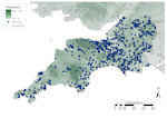
Figure 30: Distribution of finds in south-west England against topographic base map
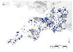
Figure 31: Distribution of finds in south-west England against constraints base map
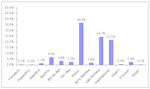
Figure 32: Chart showing PAS finds in south-west England by period
Figure 30: Distribution of finds in south-west England against topographic base map
Figure 31: Distribution of finds in south-west England against constraints base map
Figure 32: Chart showing PAS finds in south-west England by period
As in much of western Britain, topography plays a major role in this region (Fig. 30). In the far west, Cornwall and Devon are dominated by high ground, much of which is over 150m OD. Large areas of Dartmoor and Exmoor, and parts of Bodmin Moor are outside the range for ploughzone. Elsewhere, ground does not rise over 300m OD, but the Quantocks, Mendips and southern Cotswolds all rise over 150m OD along the western side of the region bordering the Bristol Channel, and along the south coast the Downs and Blackdown Hills in Dorset and Salisbury Plain in Wiltshire reach similar heights. In Devon, Cornwall and Dorset the rivers tend to drain from high land directly into the sea, with the Exe and Tamar the major waterways, but further north most rivers either run through the Somerset levels or into the Avon, then draining into the Bristol Channel.
Urbanism in south-west England is relatively restricted, mostly confined to the coastal zone, Somerset Levels and its surrounding area (Fig. 31). Bristol, Plymouth, Poole and Torbay provide the areas of most sustained urban settlement. There is little woodland and none on a large scale, and only three designated danger zones, the military zones on Dartmoor, Salisbury, Swindon and to the west of Poole.
In total, 7593 finds have been reported in south-west England, accounting for 6.2% of the national assemblage (Fig. 7). Of these, Devon and Cornwall account for only 20.1% (1528 records) of the regional assemblage, other areas 79.9% (6065 records), highlighting the differences seen in the distribution (Fig. 30). A breakdown of the assemblage by period (Fig. 32) shows that it is dominated by Roman material, followed by Late and Post-medieval, between them making up 82.3% (6253 records) of all records. Prehistoric material accounts for 13.1% (1003 records), of which Neolithic finds make up nearly half (488 records), Early Medieval a paltry 1.6% (122 records), modern and foreign material 0.5% (41 records) and undated material 2.3% (174 records).
The numbers of finds made decreases dramatically as one moves further south-west. In Devon and Cornwall most finds have been made in the lower lands of the coastal zone, especially around Exeter, St Austell and Bideford. There is an even spread of finds across the rest of the region, although there are visible concentrations on the Somerset Levels and in Wiltshire to the north of Salisbury Plain, both reflected in the kernel density plot (Fig. 5). Across the region there is a general correlation between finds and waterways, but Roman roads appear to have little effect. In Devon and Cornwall most finds are also in the vicinity of a modern A-road but this is less defined elsewhere in the region.
The potential constraints on the data (Fig. 31) make a visible impact, with few finds in these areas. A total of 584 finds (7.7%) were made within areas where constraints on recovery were calculated (Fig. 33), mostly in urban areas (366 records, 4.8%). Very few finds were made above 300m OD (15 records, 0.2%), with more finds from the danger zones, especially Salisbury Plain (199 records, 2.6%). Given the low levels of urbanisation across south-west England, the effect on finds recovery is minimal and, unlike other areas (e.g. West Central England), there is little clustering of finds around urban areas, with the possible exception of Swindon.
The low numbers of finds from the far south-west (Devon, Cornwall and western Dorset) attests to the historically lower settlement density in the region or the isolation of its inhabitants, especially away from the coast, from at least later prehistory (Cunliffe 2001). Further north and east, patterns of recovery are more akin to those seen in adjacent regions, although there appears to be a less targeted approach to finds recovery than seen further east, with little correlation with the routes of Roman roads in Wiltshire or South Gloucestershire. Salisbury Plain has a marked effect on finds recovery in southern Wiltshire, providing a large blank spot in an otherwise finds-rich area.
The breakdown of the region's assemblage by period broadly follows the national trend, although levels of prehistoric material are relatively high owing to a large number of reported Neolithic flint finds. Finds of an Early Medieval date are particularly low, probably indicating the isolation of the region at this time, with proportions of finds in the Roman and Late Medieval periods similar to much of the rest of Western Britain.
© Internet Archaeology/Author(s)
URL: http://intarch.ac.uk/journal/issue25/2/2.4.2.6.html
Last updated: Tues Apr 21 2009