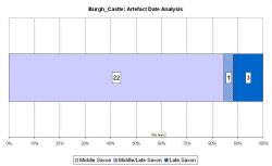
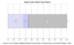
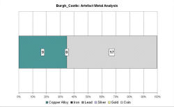
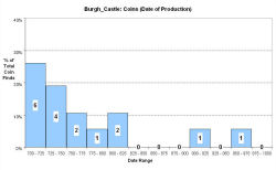
Fingerprint charts for i) artefact date analysis, ii) artefact type analysis, iii) artefact metal analysis and iv) coins – date of production
Reference: Johnson 1983
Archives:
http://ads.ahds.ac.uk/catalogue/search/fr.cfm?rcn=NMR_NATINV-1397357
Burgh Castle is 5km west of Great Yarmouth, surrounded by low-lying marshland, and situated on a spur of land that was known as Lotheringland, formerly a large estuary. The Saxon Shore fort is believed to have been the site of the monastery of St Fursey, founded in the early 630s. Bede records that St Fursey's monastery was at Cnobheresburg, a name that has long been associated with Burgh Castle.
Excavations by the late Charles Green within the south-western part of the fort revealed an Anglo-Saxon inhumation cemetery, radiocarbon dated to between the 6th and the 10th centuries, and traces of a large timber building with a clay floor immediately to the south of the cemetery were identified as possibly the remains of part of a church. Evidence found in excavations, including pottery, suggests the fort was occupied during a period between the mid-7th and the 9th centuries. Early Saxon brooches, Middle Saxon coins, and brooches, and Late Saxon metalwork, including brooches, have been found in the parish. The VASLE dataset is derived from the Norfolk HER and the EMC. A Late Saxon field system has been excavated by the Norfolk Archaeological Unit.
Like Caistor St Edmund, Burgh Castle is an example of a Roman site yielding much Anglo-Saxon metalwork and sceattas, probably because it became the location of an early monastery. The present church lies outside the Roman fort but may have been re-sited here when the construction of the Norman motte removed the earlier church associated with the Middle Saxon cemetery (Pestell 2003, 131).
Fingerprint charts for i) artefact date analysis, ii) artefact type analysis, iii) artefact metal analysis and iv) coins – date of production
© Internet Archaeology/Author(s)
URL: http://intarch.ac.uk/journal/issue25/2/4.4.7.html
Last updated: Tues Apr 21 2009