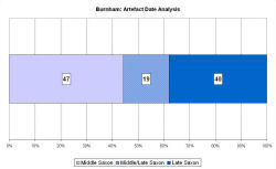
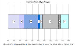
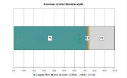
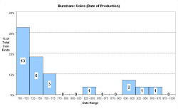
Fingerprint charts for i) artefact date analysis, ii) artefact type analysis, iii) artefact metal analysis and iv) coins – date of production
Reference: Rogerson 2003
Archives:
http://ads.ahds.ac.uk/catalogue/search/fr.cfm?rcn=EHNMR-1336475
The modern village of Burnham Market lies 3km south of the north Norfolk coast. The Middle Saxon site lies north and east of the village on both sides of the Goose Beck, a tributary of the River Burn which flows into the North Sea. The name Burnham simply means literally 'river estate'. Rogerson (2003) suggests that the junction of the stream and river formed the focus for settlement and that the estuary provided sheltered mooring for coastal traffic. Three modern parishes join within the Middle Saxon site. Burnham was probably the heart of a larger estate, which then fragmented to form the different manors and parishes of the Burnhams (Pestell 2003, 127).
Field-walking from 1983 led to the recovery of Middle Saxon pottery, and from 1990 metal-detecting recovered 5th-7th century metalwork, possibly from a cemetery, plus 8th-9th century coins and other non-ferrous finds. The VASLE dataset is derived from the Norfolk HER and the EMC. The site appears to extend over roughly six hectares.
Middle Saxon pottery and high-quality continental metalwork therefore suggest that Burnham was a market or trading centre during the Middle Saxon period, developing throughout the Late Saxon period. The settlement then probably shifted its focus slightly to where the present village is. Excavation has revealed ditches that formed part of a Late Saxon field system.
Fingerprint charts for i) artefact date analysis, ii) artefact type analysis, iii) artefact metal analysis and iv) coins – date of production
© Internet Archaeology/Author(s)
URL: http://intarch.ac.uk/journal/issue25/2/4.4.8.html
Last updated: Tues Apr 21 2009