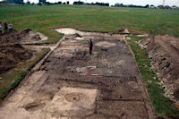
Figure 3: General shot of the East Entrance showing houses 547, 851 and 848, looking north
The Stonehenge Riverside Project's (SRP) excavations at the eastern entrance discovered that both colluvium and post-medieval activity had acted to seal the later Neolithic deposits on the site. The coincidence of these post-depositional processes with an area of such focused Neolithic activity has contrived to preserve a series of deposits rarely encountered in Britain. The majority of remains of later Neolithic sites in southern Britain are either upstanding monuments or truncated sub-surface features such as pits and ditches. What we are most usually missing, and what was found at Durrington Walls, are the ground surfaces that Neolithic people inhabited (Fig. 3). Owing to their fragile nature, these types of contexts are most commonly truncated by subsequent ploughing and remain now primarily as surface scatters of flint artefacts. Without the survival of habitation sites with which to compare them, it has often been difficult to understand exactly what these ploughsoil assemblages represent (Chan 2003, ch. 2). Relict land surfaces do survive beneath later earthworks, but the spatial extent of such preservation is often limited. Furthermore, the unusual character of their preservation (burial during the construction of a monument) can make it hard to assess whether the remains represent formalised activities that took place as part of the construction of the monument itself (Thomas 1999, 24). In either case, on no occasion has a later Neolithic land surface been excavated in southern Britain that contains such extensive remains of an occupation site. The recent excavations revealed a series of seven houses flanking a large avenue connecting the timber monument known as the Southern Circle to the River Avon via the eastern entrance of the henge (Fig. 4). The other significant finding was that the construction of the bank at Durrington Walls post-dated the majority of activity in the area of the East Entrance, including the houses and the midden contexts. Hence, the henge does not appear to have existed as a monument defined by banks and ditches during the occupation of the houses on this part of the site.
Figure 3: General shot of the East Entrance showing houses 547, 851 and 848, looking north
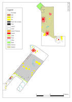
Figure 4: Plan of the main excavated contexts at the East Entrance after the 2006 field season. Drawn by M. Dover
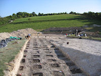
Figure 5: Midden 593 during sampling, looking south
In recognition of the importance of the occupation surfaces at Durrington Walls all such deposits were excavated on a 0.50m² or 1.00m² grid to retrieve any spatial patterning associated with activity areas or depositional practices across the site (Fig. 5). The recovery of the contextual and spatial component of the data enabled a detailed spatial analysis utilising a GIS to investigate the composition, density and distribution of different elements of the assemblage from a variety of contexts. This analysis steps beyond traditional techno-typological analyses of worked flint and is essential for the detailed interpretative approach adopted for the analysis of worked flint from the site. As will be shown, this approach has not only aided in the analysis of the assemblage of worked flint, but is integral to our interpretation of the use and relationship between the structures and depositional contexts on the site.
Given the excellent level of preservation in the area of the East Entrance, our hope is that the site will enable us to study aspects of late Neolithic society that we rarely have access to. These aspects relate fundamentally to the organisation of a settlement, and as a corollary, can be expected to inform us about a great many facets of the form and character of Neolithic society
© Internet Archaeology/Author(s) URL: http://intarch.ac.uk/journal/issue26/2/2.html
Last updated: Wed May 27 2009