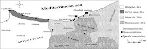
Figure 1: Location of Iberomaurusian open-area sites within the lower Isser valley
Iberomaurusian is a name given by Pallary (1909) to a group of microlithic bladelet assemblages that largely appear on the coastal zone of North Africa, during the Late Upper Palaeolithic, corresponding to the Heinrich Climatic Event I (Barton et al. 2007). This culture lasted for approximately 12,000 years. The corrected dates of the oldest layers provide ranges of 21,607-18,841 cal. BC (MC-822) at Tamar Hat in north-eastern Algeria (Saxon et al. 1974) and 22,975-20,642 cal. BC (GIF-2587) at Taforalt in eastern Morocco (Roche and Delibrias 1976), both at 94.4% confidence interval.
The evidence of Iberomaurusian human occupation in the lower Isser valley (north-eastern littoral of Algiers) comes from open-area sites from which a surface collection was made of archaeological remains, except for Courbet-Marine and Musoir sites; this last yielded a few archaeological remains (Balout 1946; Brahimi 1970). A common feature of these sites is their relative concentration at the foot of Djebel Bou Arous (Fig. 1). In addition, prehistoric occupation in caves or rock shelters is unknown as the coastal zone was immersed by a sea-level rise at the end of the Late Glacial Maximum.
Figure 1: Location of Iberomaurusian open-area sites within the lower Isser valley
Courbet-Marine is an open-area site located south-west of Zemmouri El Bahri village, about sixty kilometres from Algiers (Ménerville topographic map at 1:50,000; x = 576.70; y = 388.50). This site was found on the edge of a continental terrace bench at 15m above the actual sea level, and was about 100m away from the sea. Although discovered by the geologist Aymé in the late 1940s, it was not until 1964 that the researchers of CRAPE collected prehistoric remains from a surface area of about 40m². Thereafter, trials were done by Ramendo in 1968, followed by an excavation directed by Brahimi in the same year.
The excavated area, entirely sandy and spreading over an area of 6m², was excavated and archaeological material was taken systematically every arbitrary 10 cm unit. The stratigraphy of Courbet-Marine is shown in Figure 2. It contains a sandy layer clear of 15 to 20 cm thickness which overlies an undisturbed ashy layer of 20 to 30 cm thickness. At the south of this area, a trench of about 3.50m long and 1m wide was opened to follow the lateral extension of an ashy layer, considered by Brahimi (1970, 114) as an ellipsoidal hearth depression between 0.4m to 0.5m in thickness. However, as the author did not give conclusions, it is impossible to know whether it results from excavation, burning, or is any other structure.
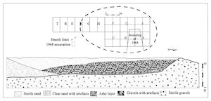
Figure 2: Cross-section north-south of the excavated area (Brahimi 1970, 113)
The stratigraphy of the archaeological deposit shows a sandy level 150 to 200mm thick at the top, above an undisturbed ashy level 200 to 300mm thick, resting on the bedrock. According to Brahimi (1970, 140), this site was not dated because of insufficient charcoal quantities. Unfortunately, faunal remains were not preserved in this sandy sediment and the total absence of marine shells in such a coastal site creates some ambiguity in interpretation. The palynological analysis indicates that the flora was of Mediterranean type, slightly different from that of the present day. However, the presence of some taxa, such as Pinus halepensis, at this site indicates a sea-level lowering of about several hundred of metres.
The lithic assemblage was the subject of a typological study carried by Brahimi, who attributed to the industry an Iberomaurusian classic phase. Moreover, this author reported that microlithic bladelets were obtained by knapping pebbles according to a simple scheme. However, many questions remain concerning the techno-economic manner of the site occupation and the characterisation of its functioning.
Our re-examination of the Courbet-Marine lithic assemblage according to a techno-economic approach, applied for the first time, has revealed new information concerning a non-local brown flint. The flint was introduced to the Courbet-Marine site in the shape of semi-finished products and was knapped according to an elaborate scheme. This data, when compared with the technology of knapped stones, indicated the factors that influenced the selection of this suitable raw material.
© Internet Archaeology/Author(s) URL: http://intarch.ac.uk/journal/issue26/28/1.html
Last updated: Wed Jul 29 2009