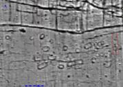
Figure 33: Trench 28AB outlined in red over geophysical results showing multiple small circular and sub-circular ditched features. The main 'ladder settlement' complex is immediately to the north.
This area, measuring 5 x 20m, was opened to examine two small circular anomalies within a group of similar features lying just to the south of the main 'ladder settlement' complex (Figs. 11 and 33).
Figure 33: Trench 28AB outlined in red over geophysical results showing multiple small circular and sub-circular ditched features. The main 'ladder settlement' complex is immediately to the north.
The evidence relating to plough damage discussed above indicates that these features occupied a slightly raised area that has been truncated by recent ploughing; the two features within the area of the trench are less clear than many of the other examples. The trench location was, however, constrained by the need to cause the minimum damage to the turf crop. As seen in the geophysical survey this feature class includes small circular and sub-rectangular enclosures ranging in size from 2.5m in diameter to almost rectangular features up to 8 x 3.5m. This group, one of more than 20 groups of similar features identified through extensive survey, appears to have a relationship with a gently curving ditched trackway following the southern edge of the 'ladder settlement'. The geophysical survey indicates that the southern trackway ditch is interrupted, with a 65m long gap adjacent to this group of ditched features.
Without the protective covering of blown sand, the archaeological features cut into the natural sandy and chalk gravel were clearly visible once the ploughsoil was removed. The picture that emerged through excavation is more complex than might have been expected from the geophysical survey alone. Multiple intercutting ring-ditches covered most of the exposed area, cut by two later linear features in addition to the extensive plough cuts (Fig. 34).
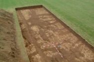
Figure 34: Area 28AB seen from the north, looking south after removal of the plough-marks. The most southerly of the ring-ditches correlates with one of the examples seen in the geophysical survey.
Fragments of at least 11 different circular and penannular ditched features were examined, reflecting long term reuse of the area. The shallower ditches had been so severely truncated by ploughing that it was impossible to reconstruct their full layout and extent. Before examining the evidence for function, it is important to establish the nature of the features, the largest and most intact of which were reflected in the magnetic survey results. In the northern third of the trench an almost complete penannular ditch, extending beyond the trench to the east, had a small pit near the centre that had the ploughed-out remnants of a deposit of burnt stone and charcoal at the surface. A second ring-ditch extended beyond the limits of the trench to the north and west (Fig. 35). There were no ring-ditch features in the southern third of the trench but, in the centre, in addition to two major ring-ditches, there was evidence of a number of earlier overlapping examples (Fig. 36).
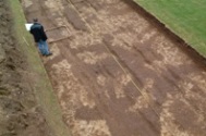
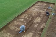

Figure 35: The northern end of 28AB, showing an almost complete penannular ditch with a deposit of burnt stone and charcoal, mostly cut away by a later fence line and recent ploughing near the centre. Figure 36: 28AB. Work in progress removing the fills of the late fence-slot and gullies that cut through the ring-ditches from south to north. Note the large number of intercutting features in the centre of the area. Figure 37: Screen dump showing the matrix linked both to the primary context record and the digitised drawings being used to generate a plan showing the sequence of construction of the 'barrowlets'.
Given the similarity between the fills of these different features it is often difficult to be totally confident in determining the stratigraphic relationships between features; however, the most substantial of the ring-ditches also appeared to be the latest, and by mapping the stratigraphic diagram to the digitised plan we have been able to establish a sequence for the central ditch group (Fig. 37). In the centre of the area no less than six ring-ditches intercut, in an area that was also disturbed by the cutting of a later shallow ditch or gully. At least one of these intercutting rings represented a penannular rather than a ring-ditch. The two most complete examples appeared to incorporate internal pits within the enclosed area, which in one case, 028AB00135, contained large burnt sandstone fragments at the surface. Charcoal and small fragments of calcined bone, associated with the burnt sandstone and also distributed across the area and within some of the ring-ditch fills, suggest that these small structures were associated with cremation burial. The term 'barrowlet' has been adopted to describe them. The discovery of several hundred of these features, which appear to show a variety of plan-forms including ring-ditches, penannular ditches and sub-rectangular or ovate arrangements, seemed to form a previously unidentified regional class of monument. Since the excavation was completed, similar and directly comparable features have been excavated at Sutton Common in 2003, where they were also associated with cremations (R. Van de Noort pers. comm.). The shallow pits found within the enclosures with fragments and flecks of calcined bone contained very little, and are therefore difficult to interpret. The cremations, it appears, were not buried deep in a central pit but must have been within a mound superstructure. The enclosing ditches were up to 75cm wide at the top, up to 30cm wide at the base and up to 50cm deep, with a V-shaped profile in the uneroded lower half of the section. In this area they were cut into chalky sands and gravels and yet there was little indication of erosion of the gravel sides or of gradual accumulation of soils filling the ditches. In the case of 028AB00077, the best-preserved example, the excavation of the ditch would have produced four to five cubic metres of upcast, mostly of loose gravel, enough to cover the interior to a depth of about half a metre. It is surprising, therefore, that there was little clear evidence of a rapid filling deposit in the base of the ditch or slot. During excavation, undulations in the primary silts, which were no more than 10-15cm deep, may indicate that the ditch or slot had originally contained some sort of timber shuttering or vertical planking. If this was the case the evidence was not clear. Subsequently the partial excavation of another example in West Heslerton (Heslerton Parish Project Site 072) during 2003 revealed clearly defined post-holes in the base of the slot (Fig. 38).
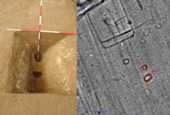
Figure 38: Post settings in base of 'barrowlet' slot and geophysical survey showing other examples and trench location on Site 072.
Two later features cut through the trench: a linear gully incorporating two or more recuts or cleaning phases, which probably extended right through the area but was ploughed away in the northern part of the area, and a fence slot incorporating a very well-preserved timber slot filled with gravel along its length. A single small sherd of probably Anglian pottery suggests that this feature could be associated with the settlement immediately to the south of the area. Figure 36 shows these two later features under excavation.
© Internet Archaeology/Author(s)
URL: http://intarch.ac.uk/journal/issue27/2/4.3.2.html
Last updated: Wed Nov 11 2009