PREVIOUS
NEXT
CONTENTS
HOME
4.3 Trench summaries
4.3.1 028AA
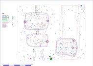
This trench, measuring ten metres square and situated over three anomalies interpreted as Grubenhäuser, reflected a relatively simple sequence (Figs. 28-32). Late Iron Age and Romano-British activity is reflected in the high density of ceramics from these periods (Fig. 18). The density of all ceramics within the buried soils and base of the blown sands is quite high, with a density of 5.83 sherds per square metre; the density within the cut features only rises to 8.65. The high density of Iron Age pottery is of considerable interest given the relative lack of associated features. The ceramic distribution and density may simply indicate that the buried soils relating to the Roman and earlier periods remain relatively intact in this area, with the ceramics suffering minimal post-depositional damage and erosion. The plot showing the distribution of the ceramics by period, with symbol sizes based on sherd weight (Fig. 18), shows a marked reduction in density within the furrow or trackway (028AA00025) where the buried soil has been eroded or deliberately removed.
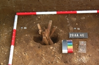
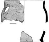
Adjacent to the southern limit of excavation a small pit (028AA00046), of post-hole proportions, had been dug and then apparently deliberately filled. At least six cattle ribs and a scapula had been placed vertically in the pit and then a small pot had been placed within the tripod arrangement caused by the crossing of the rib bones; the vessel had probably been complete, although the base and more than half the vessel had been lost or spread through plough damage (Figs. 19 and 20). A scatter of sherds extending a metre beyond the centre of the pit from the spit removed above the feature included further fragments of the same fabric, including a single base sherd. The distribution of these sherds within the buried soils at the base of the blown sand may indicate that the deposit was damaged in antiquity and then buried beneath the blown sands, supporting the suggestion that in this part of the site recent damage is slight.
Although the pottery appeared to be of Early Anglo-Saxon form, the fabric appeared to be Iron Age. A pair of radiocarbon dates were obtained from two of the ribs, indicating a Middle Iron Age date (OxA-12285-6: 2467 ± 27 BP, cal BC 760-410). The nature of this deposit, its location some 250m to the south of what appears to be the main settlement focus and the high density of Iron Age pottery in the area may reflect areas of extensive activity not documented through the geophysical survey.
A second feature, a narrow ditch or slot (028AA00067, 69, 71), aligned north-south, which appeared on excavation to have been cut away by two Grubenhäuser in the western side of the trench may be of Iron Age date, although the high-resolution geophysical survey (Fig. 10) appeared to indicate that the ditch could have cut through the northerly Grubenhaus; this was not confirmed through excavation – the Grubenhaus fills were distinctive and different from those of the ditch. We could find no obvious reason why the geophysical response over the line of the ditch contrasted with that to either side; only further more extensive excavation would allow us to establish the date of the ditch with greater confidence, and we may have to accept that this evidence can be read in two different ways. It is possible that the ditch or slot does post-date the Grubenhaus and that it was dug and immediately backfilled, which might make a cut difficult to identify but could significantly change the magnetic properties of the fill.
The principal phase of activity in this area related to the three Early Anglo-Saxon or Anglian Grubenhäuser. Area 28AA was selected to allow us to test the interpretation of the geophysical survey results and confirm the interpretation of the series of large sub-rectangular anomalies as Grubenhäuser; this proved to be the case. A second objective of the excavation was to compare and contrast these features and the material evidence with that from the excavated settlement at West Heslerton 2.5km to the east. The three Grubenhäuser excavated here are directly comparable in terms of scale and material culture evidence with those examined at West Heslerton, and in terms of the evidence would be indistinguishable from the early examples at West Heslerton. The, admittedly small, ceramic assemblage excludes the single certainly Middle Saxon fabric identified at West Heslerton (see Appendix 1 for a full discussion of the Anglo-Saxon ceramics). Looked at as a whole there are subtle differences in the ratios of the different fabric types between the two sites but there is no reason to believe that this reflects anything other than the different scales of the excavations, comparing the results from three Grubenhäuser with that from c. 150. Other debris, discarded in the pits left following the abandonment of these structures, included large amounts of animal bone, nearly 75% of the assemblage, fragments of imported Niedermendig Lava querns and discarded fragments of unfired clay loom-weights, as we would expect. Given the overwhelming wealth of evidence that points towards the role of the abandoned pits for secondary or tertiary rubbish disposal, providing no secure relationship between the function of the original structure and the fills of the abandoned pit, isolated examples offer limited insight into the settlement as a whole (see Tipper 2004).
The three Grubenhäuser examined here are of two-post or gable-post type, the same type as all of those, where post-holes were identified, excavated at West Heslerton. All three are aligned broadly east-west, the two examples that occupy much of the western half of the trench (028AA00022 to the north and 028AA00023 to the south) appear to respect each other, but allowing for the structural extent beyond the confines of the pit, dug to provide a dry air cavity beneath the floor, it seems very unlikely that both could have stood at the same time. There was no direct stratigraphic relationship between these two and there was no secure dating evidence that could be used to demonstrate the sequence.
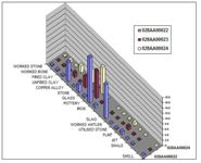
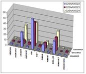
Figure 21: Relative finds frequency by material from Grubenhäuser (excluding animal bone and charcoal).
Figure 22: Area 28AA. Relative frequency of ceramics by period from Grubenhäuser.
A comparison of the assemblage combinations in the three Grubenhäuser indicates that while 028AA00023 and 028AA00024 have a closely matching assemblage combination, 028AA00022 is quite different (Figs. 21 and 22). Grubenhaus 028AA00022 contained more than 120 fragments of slag, compared to one each in the other features, more than twice as many fragments of fired clay and over 430 fragments of retrieved charcoal as opposed to 9 and 19 from the other features. Only nine fragments of slag were found in the buried soils around the buildings, four within 2 metres of the north-east corner of 028AA00022 and three further fragments within 2.5 metres of the south-western corner. Although the source of the material is not known, it appears to be different from that used to fill the other two features. It is likely that this reflects a chronological difference, although without any absolute dates we cannot identify the exact sequence. Despite the apparent similarity of the assemblages in 028AA00023 and 028AA00024, these two features are only 1.5 metres apart and it seems unlikely that these two structures could have stood at the same time. A more detailed comparison of the small Anglian ceramic assemblage from these three structures gives added support to the suggestion that each went out of use or at least was filled in at a different time. The Early and Middle Saxon ceramic fabrics of the area have been the subject of intensive study as part of the analysis of the material from West Heslerton (Powlesland et al. in prep). All of the Anglo-Saxon ceramics recovered from Site 28 can easily be identified according to fabric series identified at West Heslerton; critically, not all the fabrics identified at West Heslerton are present, in particular those introduced during the Middle Saxon period. Grubenhaus 028AA00022 contained the widest range of fabrics with 13 sub-groups present, 028AA00023 included material from 7 sub-groups, while only 4 were represented in 028AA00024, which contained the largest ceramic assemblage both by frequency and weight (Figs. 23 and 24). The assemblage from 028AA00024 is biased owing to the inclusion of 28 sherds from a single vessel, which may reflect some degree of primary disposal.
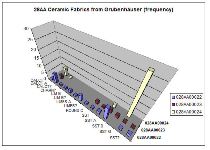
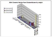
Figure 23: Anglo-Saxon ceramic fabrics represented in the Grubenhäuser in Area 28M (sherd count).
Figure 24: Anglo-Saxon ceramic fabrics represented in the Grubenhäuser in Area 28M (weight).
As was the case at West Heslerton, the fills of these Grubenhäuser all contain a large quantity of pre-Anglian material including worked flints, Iron Age and Roman period ceramics. The material is thought to be derived from turves, used in the superstructure of the buildings, which are pushed into the pit when the structure goes out of use.
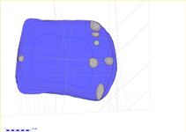
Figure 25: Grubenhaus 028AA00024, showing the row of large post-holes cut through the eastern end of the feature.
It appears that, following the infilling of Grubenhaus 028AA00024, a series of large post-holes were cut through the eastern end of the feature (Fig. 25). At first it was thought that these may have related to the Grubenhaus but one example incorporating packing had clearly cut through the fills of the Grubenhaus; the upper fills at the eastern end had been truncated and probably disturbed by a late furrow or small trackway that ran north to south across the feature. Additional post-holes inserted as repairs at the gable end of Grubenhäuser are occasionally encountered. It is possible that this had been the case and that the timbers were left in situ when the building was abandoned, leaving a situation in which the post-pipe has been interpreted as the cut of a later post-hole. The situation remains unclear, and the possibility that the row of four large posts may relate to the structure of the Grubenhaus cannot be completely discarded; the area around the Grubenhaus was carefully cleaned and, within the limited confines of the trench, no further post-holes could be found. Had these post-holes related to a post-hole building we would have expected to find other examples to the north of the Grubenhaus. The primary fill of this Grubenhaus had a spread of stone distributed across the surface; it is possible that this represents a stabilisation layer and that the structure was completely rebuilt at this stage, with the post-holes cut through the partially filled feature, this would be a most unusual arrangement although a case can be made for rebuilds re-utilising an extant sub-structure pit in a small number of examples at West Heslerton.
The latest feature encountered extended through the trench from south to north and comprised a 0.15m deep and 3m wide furrow or trackway, which cut through Grubenhaus 0280024 and was cut into the buried soil at the base of the blown sand and had in turn been filled by blown sand (Fig. 26). The feature contained no dating material but is assumed to be medieval or later in date.
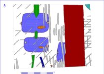
Figure 26: Plan view of Area 28AA showing the broad furrow or trackway (028AA00025 in red) cutting across Grubenhaus 028AA00024.
PREVIOUS
NEXT
CONTENTS
HOME
© Internet Archaeology/Author(s)
URL: http://intarch.ac.uk/journal/issue27/2/4.3.html
Last updated: Wed Nov 11 2009