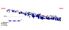

Figure 17a: Sectional view of the finds distribution in the blown sand in Area 28AC (Z magnified x10). Figure 17b: Animated sectional view of the finds distribution in the blown sand in Area 28AC (Z magnified x10).
Although only situated six metres to the north of Area 028AB, blown sand extended over the whole of Trench 028AC. The deposit was up to 0.5m in thickness and offered the potential for detailed spatial analysis of the blown sands and the material contained within it. Plough-marks relating to two ploughing events had cut into the blown sand but had not compromised the archaeological deposits beneath. The blown sand deposits are highly homogeneous, although a difference can usually be perceived between the top and bottom of the deposit in section, with leaching contributing to a darker colouring at the bottom; these deposits very rarely show any clear stratigraphic variation. The temptation to simply remove this material by machine or shovel should, however, be avoided; careful excavation coupled with three-dimensional recording of all finds positions does reveal a chronological variation from the base to the top of the deposits.
Considering the natural slope at and below the surface of the field, the absolute elevations of the finds cannot be used to support a simple computer-based analysis of variation in material within the deposit. By employing a surface model of the site or the blown sand deposit, at its surface, we can, using a function within our GIS software, establish the absolute depth of each object from the surface. Using this function, which interrogates the surface model and subtracts the objects' recorded elevation, the record can be updated with a field describing the depth beneath the surface. In this example, Area 028AC, which at the surface shows a 55cm drop in elevation from the south to northern limit of the trench, comparison between material based on absolute elevation gives a false impression of the evidence. In contrast, an examination of the material based upon the depth below surface information, indicates that the overall deposit of blown sand in this area includes medieval material at a depth of less than 45cm below the current land surface (BCS), while below this depth the material is exclusively Roman with the exception of some possibly Anglian sherds. The incorporation of the medieval material, including a silver penny of 13th- or 14th-century date at 44cm BCS, indicates that the upper 20cm of blown sand reflects gradual accumulation from the 13th century onwards, and the lower 25cm is an earlier post-Roman accumulation. Given the relatively small area examined and the limited amount of material recovered from the blown sand, 1275 finds including animal bone, it is clear that the method offers the potential to recover evidence that can improve our understanding of the formation of the blown sand deposit and its chronology.
Figure 17a: Sectional view of the finds distribution in the blown sand in Area 28AC (Z magnified x10). Figure 17b: Animated sectional view of the finds distribution in the blown sand in Area 28AC (Z magnified x10).
The distribution of the material contained in the blown sand is best viewed as a rotating digital plot; however, even a static sectional view can give insights into the deposit development. Figure 17 shows a sectional plot of the ceramics in the windblown sand in Area 28AC; the vertical scale is magnified by ten which emphasises the slope from south to north and the Roman and Iron Age ceramics have been plotted using symbols sized by the weight*Log(2). The relationship between the Roman ceramics and the medieval finds is quite as expected. The distribution of the Iron Age ceramics is, however, entirely unexpected with Iron Age material, with the exception of two tiny sherds, distributed in the upper 20-25cm of the deposit closely matching the distribution of the medieval material. The Iron Age fabrics are generally very light, having contained organic and lost mineral inclusions, and thus could tend to 'float' or rise up towards the surface; should this be the case we would, however, still expect to find sherds in the lower half of the deposit, assuming there are Iron Age features beneath. An alternative explanation is that the distribution incorporates material introduced through agricultural activity from areas nearby. The similarity between the medieval and Iron Age distributions may reflect far greater reworking of the soils from ploughing during the formation of the upper half of the deposit. Clearly, by applying the same techniques to larger areas we could learn much more. This analytical exercise has revealed that the blown sand, regardless of how uniform it looks, has archaeological and chronological structure reflecting a changing landscape, with intensification of agriculture from the medieval period onwards. Remarkably, given the strength of the geophysical signals showing the ladder settlement, the blown sands in this area still protect the archaeological resource from modern agriculture.
In conclusion, these three small trial trenches have shown tremendous variability in the levels of plough damage and preservation across the site. The subsurface profile is clearly quite different to that of the modern surface; some areas remain buried and well preserved, whereas others, that had once been slightly elevated, have been truncated by modern agriculture. In the worst case, Trench 028AB, the damage has been so great that no more than two new deep ploughing events are likely to destroy all evidence of some features completely.
© Internet Archaeology/Author(s)
URL: http://intarch.ac.uk/journal/issue27/2/4.2.html
Last updated: Wed Nov 11 2009