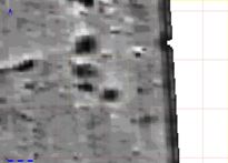
Figure 9: The boundary of Area 28AA showing over the geophysical survey image.
The ploughsoil was stripped from the three trenches using a JCB with a toothless ditching bucket. Area 28AA, measuring 12.25m east-west and 10.25m north-south, was located to cover three anomalies thought most likely to be Grubenhäuser (Fig. 9).
Figure 9: The boundary of Area 28AA showing over the geophysical survey image.
After the removal of the ploughsoil a high-resolution gradiometer survey was undertaken within the confines of the trench. The extant ploughsoil at the limit of excavation affects the data recovered and reduced the effective area to a nine metre square, with readings collected at 25cm intervals in both axes. The high-precision survey added no new features, such as the post-holes identified using the same technique at West Heslerton (Powlesland et al. 1998). However, excavation indicated that, with the exception of a possible shallow hollow-way running north-south through the area, which is visible with hindsight, all features identified in the ground were identified in the survey, apart from a small pit, which was within the magnetically disturbed area adjacent to the southern limit of excavation.
Although the high-resolution survey showed no new features, it shows interesting variations in the magnetic signal over the Grubenhäuser selected as the target for the excavation (Fig. 10). When plotted with the excavation plans and distribution of iron objects overlain we can clearly see a magnetic iron spike, which appears to relate to a single object, a fragment of corroded iron sheet; other iron objects may have contributed to the signal in some features but do not show the same correlation. In the northerly Grubenhaus (028AA00316) a feature is indicated running north to south bisecting the feature. On excavation it appeared that the Grubenhaus had cut through an earlier ditch; the magnetic evidence appears to indicate the reverse, giving the sort of result we might expect if a narrow trench had been cut through the organically rich fills of the Grubenhaus, removing some and being refilled with less magnetically enhanced material.
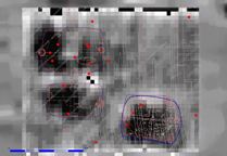
Figure 10: High-resolution gradiometer survey of Trench 028AA overlain by excavated feature plan and distribution of iron objects.
Area 28AB was situated so as to cover two of a number of small ring-ditch features lying to the south of the ladder settlement and 110m to the north of 28AA. The trench was aligned parallel to the eastern edge of the field and measured 20.1m north to south and was 5.2m wide (Fig. 11). The third trench, Area 28AC, was 35m long and 1.5m wide, cutting across part of the ladder settlement and situated 6.5m to the north of Area 28AB (Fig. 11).
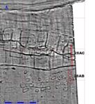
Figure 11: The location of Areas 28AB and 28AC in relation to the geophysical survey.
© Internet Archaeology/Author(s)
URL: http://intarch.ac.uk/journal/issue27/2/4.html
Last updated: Wed Nov 11 2009