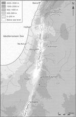
Figure 1: The location of the Faynan (Barker et al. 2007, 4).
The Faynan region of southern Jordan was a copper-mining district, exploited from the Bronze Age until the Mameluk period (3600 BC-AD 1300). Located on the eastern edge of the Wadi 'Arabah in south-western Jordan, it is approximately 40km from the Israeli border, falling about halfway between the Dead Sea and the Red Sea.
During the Roman and Byzantine periods (c. AD 106-500) the imperial administration in charge of the Faynan used a variety of methods to regulate and direct the copper industry, ensuring large-scale copper production (see Barker et al. 2007, 304-48). This article argues that one of these methods was the creation of a landscape of surveillance and that this proposal can be examined with viewshed analysis. Although viewshed analyses are commonly used in archaeology, they are rarely applied in a methodologically rigorous manner. To generate the viewsheds the unique environment of the Faynan and local limitations of human visual acuity are taken into account, so that the viewsheds are regionally appropriate.
Surveillance has long been recognised as having the power to encourage discipline and act as a controlling mechanism (Foucault 1991, 195-230). The data created by the viewsheds were analysed in the light of this panoptic theory. American historical archaeology has used theories of surveillance as described by Foucault to study the landscape of plantations. This paper uses comparative analysis between the Faynan and historic plantations to explore how the use of surveillance may have maintained the hegemony of the administrators and enforced hierarchy, especially over the convict population.
© Internet Archaeology/Author(s)
URL: http://intarch.ac.uk/journal/issue27/4/1.html
Last updated: Tue Nov 3 2009