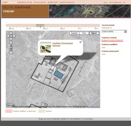
 Figure 1: Time-map feature, showing monuments of Ramses IX
http://dlib.etc.ucla.edu/projects/Karnak/timemap#
Figure 1: Time-map feature, showing monuments of Ramses IX
http://dlib.etc.ucla.edu/projects/Karnak/timemap# Curator, Department of Ancient Egypt and Sudan, The British Museum, Great Russell Street, WC1B 3DG. Email: [email protected]
Cite this as: Spencer, N. 2009 Review of Digital Karnak [Website], Internet Archaeology 27. https://doi.org/10.11141/ia.27.6
The Digital Karnak Project aims to provide expert material on the Temple of Amun-Ra at Karnak and includes a 3-D Virtual Reality model of the temple as well as videos and maps. Available: http://dlib.etc.ucla.edu/projects/Karnak/
The temples and associated buildings at Karnak together form one of the largest religious complexes ever constructed, but our comprehension of their function and development over time has been made difficult because of the scale and long history of the complex. Further, the piecemeal nature of much of the archaeology that has been conducted in the last two centuries, and the even more fragmentary published output, means it is rather difficult for young Egyptology students, and especially non-Egyptologists looking for cultural comparanda, to easily gain a meaningful insight into the temples, their function, and development.
Egyptology has fared rather poorly on the internet. Sites of dubious scholarly value abound (some amusing: www.thepump.org), and though more reliable resources can be found through recognised Museum and University portals, these are often restricted to individual collections or projects. Turning to Karnak, the Centre Franco-Égyptien d'étude des temples de Karnak (CFEETK) has been responsible for excavations at the site since its formation in 1967, continuing the long history of French involvement at Karnak, going back through such luminaries as Henri Chevrier, Georges Legrain, Auguste Mariette and Gaston Maspero. The CFEETK has its own website (www.cfeetk.cnrs.fr), aimed at a more scholarly audience, with reports on field seasons available for download.
Where does Digital Karnak sit within this online landscape? Three principal goals are set out for the project: (1) to assemble databases of information related to Karnak, (2) build an interactive computer model of the site, and (3) create a series of resources using the model and databases that are available online, primarily for undergraduate education.
It follows the creation of the Digital Roman Forum (http://dlib.etc.ucla.edu/projects/Forum), and echoes many of the features of that site. The FAQ section of the site states that Firefox is the recommended browser, but I encountered no obvious difficulties with Firefox or Internet Explorer. Images, and the rendered model, download quickly. It is free, something that will hopefully also apply to the UCLA Encyclopaedia of Egyptology (www.uee.ucla.edu) when its full version is launched in 2010.
Karnak represents a perfect case study for using virtual reconstructions, satellite imagery and interactive tools to allow interested parties to explore the archaeological site in many different ways. Karnak lends itself to periodisation, something very difficult to visualise when actually among the jumbled up ruins of the temple, with late phase building shrouding much of what went before, and many buildings having been dismantled or moved, even in ancient times. The timemap feature is particularly useful at disentangling the complex construction histories, with maps overlaid on a Google Earth image, and pop-up boxes to allow further investigation of individual buildings. Each 'feature' or monument is then associated with an archive, comprising model rendering, photographs (new and old), videos and object references.
Figure 1: Time-map feature, showing monuments of Ramses IX
http://dlib.etc.ucla.edu/projects/Karnak/timemap#
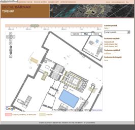
Figure 2: Time-map feature, with Google Earth layer de-activated. Note the visual clarity to the plans.
http://dlib.etc.ucla.edu/projects/Karnak/timemap#
The mass of data here would take much time to work through, so for the purpose of this review I picked out a Karnak structure pertinent to my own research: the massive mudbrick enclosure wall of Nectanebo I (4th century BC), which still defines the Amun complex today. Unlike many of the buildings featured on the site, this remains in very good condition and it is not difficult to visualise its ancient appearance. The main resources on the wall are located under a rubric titled 'Enclosures and Gates'; the page design is rather unfriendly. Sadly, the pictures are rather small, and the title is followed by an unsightly outbreak of links: a whole page length has to be scrolled through to reach the text.
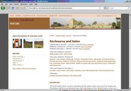
Figure 3: Unfriendly layout on core information page, with a frenzy of links and small images
http://dlib.etc.ucla.edu/projects/Karnak/feature/EnclosuresAndGates
The three sections of text, on walls of different period, can then be scrolled through, with a comprehensive bibliography at the end. The creators of the website are to be particularly commended for their decision to state what sources were used for the model renderings, something often missing from virtual reconstructions. Surprisingly, the enclosure wall is represented with a rather small, and odd, range of images: two of the east gate, one taken in poor light, the other in even worse, leaving the gate as little more than a silhouette.
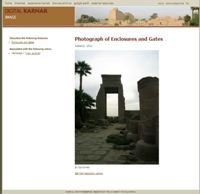
Figure 4: Photograph taken in poor light, without indication of its location (East Gate of Amun complex)
http://dlib.etc.ucla.edu/projects/Karnak/resource/EnclosuresAndGates/472
The remaining four images show parts of the enclosure wall's brickwork. For such a monument, I would have expected to be able to see, from the main page discussing 'Enclosures and Gates', images of much of the wall, especially where pierced by gateways. Aerial photos and plans should also be available, and easy to access through links. The thumbnails can be clicked through to a larger version, and a 'high-resolution' version (generally 700K) can also be accessed. None of these pages give a description of the monument in question, nor essential information such as the date the photograph was taken, and in which direction. In addition to these photos, there are two stills from the model rendering; again the selection of views seems rather random.
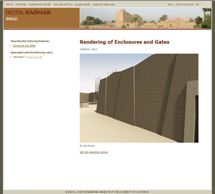
Figure 5: Still from model rendering, again without sufficient information
http://dlib.etc.ucla.edu/projects/Karnak/resource/EnclosuresAndGates/2161
With other monuments, there is a much greater range of images, but again, the quality is highly variable. For example, looking at the White Chapel of Senwosret I, one of the earliest preserved monuments at Karnak and now reconstructed in the Open Air Museum, there are 142 images. However, many are not taken in good light, particularly important to show relief detail. It truly seems that these are the best photos that could be taken on the day the photographer(s) visited this part of Karnak, rather than the outcome of a planned project to acquire good photographic coverage in ideal light. Once you are on a photograph page, you cannot navigate or scroll through others, you constantly have to click 'back'. Having a browse through the other monuments in the resources, the list looks quite comprehensive, but there is a real unevenness to the coverage: the chapel of Hakoris is shown in a model rendering, but not represented by a single photograph.
Amazingly, on some of the pages I consulted, there was not even a one-line caption to allow viewers to understand where the photographed feature can be found.
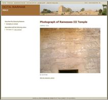
Figure 6: One of 73 images from the temple of Ramses III, with no indication of which wall, or even which room. The photograph is from
http://dlib.etc.ucla.edu/projects/Karnak/resource/RamessesIIITemple/1113
What of the model itself? The model covers most of the major buildings, and is perhaps most useful to consider how different monuments relate to each other in spatial terms.
Economies of effort are always necessary in such endeavours – in an ideal world the surfaces would be rendered with relevant digital images, so the exact architectural location of reliefs could be appreciated. Whether an additional layer could be incorporated, with some idea of the original colouring of the monuments, is another issue, and one less likely to meet with a consensus of opinion among scholars.
As with all such models, a minimalist approach has been favoured, so viewers should not expect to see what the temple may originally have looked like – there is no colour, but there is also no clutter – of people, of ancillary workshops, houses and the mass of statues left by pilgrims and visitors. Nor is there any sense of landscape – the monuments sit on a perfectly flat beige surface, reminiscent of early video games.
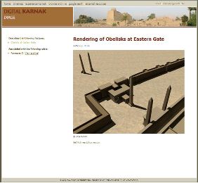
Figure 7: Rendered model of obelisks at East Gate, with featureless ground surface
http://dlib.etc.ucla.edu/projects/Karnak/resource/ObelisksAtEasternGate/1938
There are some animations of the temple model (as QuickTime movies), which run for several minutes. Examples include phase-by-phase sequences from different angles. The 'temple fly-around' does what it purports to, but the third category – 'temple walk-throughs' – are perhaps the most informative, as they give a real sense of scale and architectural progression, which one cannot get from books or plans.
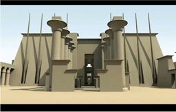
Figure 8: Still from the QuickTime movie of the 'temple walk-through' along the western axis of temple. Total time: 1m35sec
http://dlib.etc.ucla.edu/projects/Karnak/experience/AnimationsOfTheTempleModel/10
There are also short videos on such subjects as 'processional routes and festivals' or 'construction methods and building materials'. These feature embedded texts, photographs and use of the models, and some seem more like Powerpoint presentations.
However, this lack of landscape is more than made up for by the provision of a kml-file for loading the model into Google Earth. Though it naturally takes some minutes to load the full set of modelled monuments, once complete it allows a landscape-embedded fly-through of the monuments, with information balloons for descriptions of the monuments and links to the relevant Digital Karnak page. A timeline along the top of the Google Earth window allows a period-specific view of monuments to be explored – an extremely useful tool for teaching, in particular.
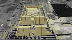
Figure 9: Digital Karnak in Google Earth. View of the Amun temple complex as it would have appeared in 1480 BC
It is not stated that this is a work in progress, which may be assumed to be implicit with online projects. In all, there is the core of a very worthwhile resource here, most strikingly attested with the model, the period-specific maps and the Google Earth facility. There are two further areas that could be developed or improved, and the potential of this site, for undergraduates, Egyptologists and enthusiasts alike, would be greatly improved.
Firstly, objects now scattered through the world's museums could be embedded in the relevant pages. A start has been made in this direction: the limestone statue of Queen Ahmose-Merytamun found before the 8th pylon, now in the British Museum, is linked to the existing online resource provided by the museum, though not the full database entry, perhaps more relevant for an undergraduate audience.
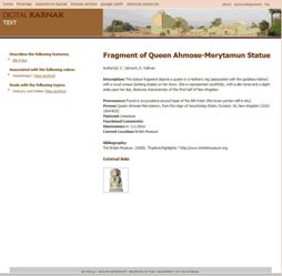 Figure 10: Page with information relating to a museum object originally found at Karnak
http://dlib.etc.ucla.edu/projects/Karnak/resource/ObjectCatalog/1839
Figure 10: Page with information relating to a museum object originally found at Karnak
http://dlib.etc.ucla.edu/projects/Karnak/resource/ObjectCatalog/1839
Secondly, a consideration of material post-dating 31 BC should be added, as the later history of the temple, and indeed the history of excavation (including the conscious destruction of late antique and more recent material to reach the stone pharaonic remains), is equally part of the site's fascinating history, and how the temples of Karnak have taken on the appearance they present to visitors today.
Internet Archaeology is an open access journal based in the Department of Archaeology, University of York. Except where otherwise noted, content from this work may be used under the terms of the Creative Commons Attribution 3.0 (CC BY) Unported licence, which permits unrestricted use, distribution, and reproduction in any medium, provided that attribution to the author(s), the title of the work, the Internet Archaeology journal and the relevant URL/DOI are given.
Terms and Conditions | Legal Statements | Privacy Policy | Cookies Policy | Citing Internet Archaeology
Internet Archaeology content is preserved for the long term with the Archaeology Data Service (ROR). Help sustain and support open access publication by donating to our Open Access Archaeology Fund.