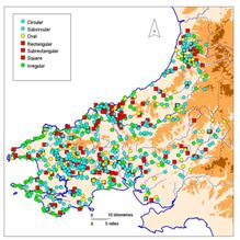
Map 5: Distribution of all sites by shape.
The general shape of each site was recorded during field visits and this was found to vary considerably, as revealed in Figures 1a and 1b. For distribution purposes these have been rationalised into: circular, subcircular, oval, rectangular, subrectangular, square and irregular (Table 6) and for ease of reading on Map 5 these have been combined into four main categories: circular/subcircular, oval, rectangular/subrectangular/square, and irregular.
Table 6: General shape of all sites.
| General shape of enclosure | No. of sites |
|---|---|
| Circular | 146 |
| Subcircular | 205 |
| Oval | 97 |
| Rectangular | 81 |
| Subrectangular | 94 |
| Square | 3 |
| Irregular | 152 |
| Unknown | 9 |
| Total | 787 |
Irregular sites (green circles on the map) are generally governed by topography and mostly comprise inland and coastal promontory forts. Circular/subcircular and oval sites (blue and yellow circles respectively) dominate the assemblage with a fairly even distribution across southwest Wales. Rectangular/subrectangular and square sites (red squares) also have a fairly even distribution but concentrations coincide with those of defended enclosures, and not with other normally larger site types such as hillforts. Within this distribution there are spikes, such as the approximately 50-50 split of circles and rectangles/squares in southeast Ceredigion. Perhaps across the rich farmland of this area the distribution of rectangular/square enclosures approximates to a separate tribal or cultural group, a group that emerged late in prehistory, as limited excavation has shown that these particular sites are late Iron Age in date. There is a less pronounced group of rectangular sites in western Carmarthenshire, which may again indicate a cultural group.
© Internet Archaeology/Author(s) URL: http://intarch.ac.uk/journal/issue28/1/3.4.html
Last updated: Mon Dec 14 2009