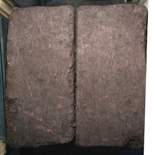
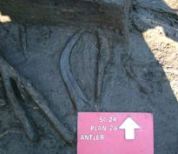
Figure 6: Slideshow of digging through the block.
Click the buttons to excavate the block. Clicking on numbered small finds reveals further information.
Overall 53 layers were excavated over a period of 734 hours, i.e. nearly 20 working weeks! During the excavation of the block it was possible to discern a number of distinct zones. These zones were not initially linked to specific contexts identified during excavation in the field, but an examination of these zones of layers and contexts was carried out post-block excavation in order to test whether associations could be made. The six zones are explained below and are broadly defined in the summary Table 1 with a brief note of the main results, which are explained further in each specialist section. The photographs taken as the excavation took place are found in Figure 6: this provides a complete run through of the excavation with brief descriptions by zone, and clicking on tagged pieces of wood (identified as being worked or interesting for other reasons) will take the reader to Table 2, which provides further information on each piece.
Zone 1 was a woody peat which had a lot of root mat within it that was intrusive from above. This was very similar to what had been observed in the trench, although at the time it had not been obvious that much of the wood was root (Fig. 7).
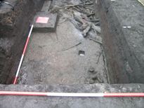
Zone 2 was marked by changes in colour and texture and there was a lot less wood in these layers and context 84 – where it did occur it was found in patches and this was more clearly observable in the trench; in the block there was a concentration of wood and this might have been misleading if the trench information had not been available (Fig. 8).
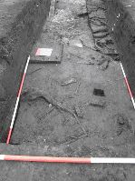
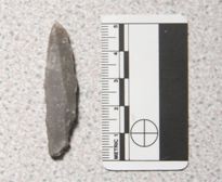
Zone 3 had more charcoal within it. This was noted on site but the sediment was otherwise the same as for zone 2 and it was classified as the same context (84). The sediment was again devoid of much wood, as can be seen in Figure 9. This zone is defined as the archaeological horizon: the level at which artefacts within the block and trench are found. There was some parallel-sided woodworking debris within these layers. In BL20 the piece of flint was found. In the trench excavations it was at this level that a 'jelly bone' (the mineral content had been destroyed from the acidity and the collagen had turned to gelatine) was found as well as some pieces of antler, including one which was found to be sticking into the block. The block was shaved back in order not to cut through it and damage it, as it was already in a fragile state (Fig. 10).
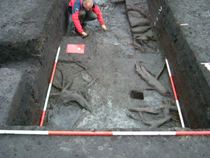
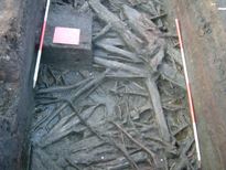
Zone 4 is likely to represent the top of the brushwood and was distinguished because the timbers within the block were different from those above and below, and may have been worked: the wood did not appear to extend into the trench. Zone 5, 'brushwood', was very evident in the trench and the block (see Fig. 11). What was evident in the trench and not the block was an interesting pattern of timbers at the base of the trench. These were flat pieces of wood that appeared to have been laid out parallel to the lake edge with one piece at right-angles to the lake edge. This is an intriguing arrangement which bears similarities to the timbers found in 1985 (Mellars and Dark 1998). They do not appear to run into the block and the ends are likely to have been severed during the block removal. These ends might have produced valuable information about the possible working of these timbers and highlights one of the problems of removing blocks and cutting through sediments.
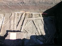
Zone 6 was a fine twiggy sediment which lay beneath the wood and above the underlying glacial clay. The twigs and clay had been mixed around in both the trench and the block, with a higher mineral content than above (Fig. 12).
Overall, the results were disappointing. The only artefact found during excavation was a piece of flint, a mèche de foret or an awl, with abrupt bilateral retouch tapering into a sturdy point at one end (Fig. 13). It is similar to several examples recovered during Clark's excavations (Clark 1954, 107, fig. 39). These pieces are common at Star Carr, but relatively rare elsewhere in the Vale of Pickering. It was not particularly surprising that so little flint was found in the deposits from this part of the trench because it represents the lake edge, where flint is always rare. This was the case in the 1985 excavations (Mellars et al. 1998, fig. 3.11) and in our 2006 excavations in trench SC22 and in the 13 other Mesolithic sites excavated around Lake Flixton (Conneller and Schadla-Hall 2003). Usually these areas lack evidence of flint working, with little or no debitage; instead the lithic material seems to represent toolkits discarded in the course of activities presumed to have been carried out at the lake edge, such as antler working or heavy duty processing. This is further confirmed by the lack of flint in the residues from flotation of these deposits.
Forty-one pieces of wood from the block appeared to be, or were likely to be, worked and were therefore examined and recorded in detail using the pro-forma wood sheets. Eighteen pieces from the block were identified as debris i.e. pieces of wood rejected or discarded during the process of working wood. Of these, four are bark, six are radially aligned woodchips, five are tangentially aligned woodchips and the remaining seven are distinctive, parallel-sided pieces of a type that had already been noticed during examination of material from the conventional excavation. This parallel-sided detritus is of particular interest as further evidence of a woodworking technique first noticed during examination of material from earlier excavations (Taylor 1998, 61-62). As far as it is possible to judge, the general proportion of the different categories of wood from the block is similar to that from the conventional excavation, but it is difficult to tie in the layers precisely. What can be noted is that evidence for woodworking debris appears throughout the block.
There were one or two pieces from the block which were problematic. B0332/ B0337 is an important piece of timber, apparently hewn but which was truncated when the block was cut up. The length achieved by uniting two sections appears to be reasonably accurate – 669mm – but the width measurement is uncertain because of crushing and tearing of the extremely frail material when it was truncated. It was certainly originally more than the 140mm that survived. The position was further complicated because the piece tapers and narrows in an unusual way. The cut coincides with this change of shape, making it impossible to join the two parts satisfactorily. There is also a group of pieces: B0333, B0334, B0335, B0336, B0340, B0371 and B0380, that are possibly roots and parts of the base of a coppice stool. The truncation of these pieces and the loss of the macro-pattern makes interpretation difficult. There was a similar problem with B0349 and other pieces which could be either root or debris. Root is often easier to identify in the ground, when the distinctive shape and habit of the growth pattern can be identified.
For the most part the specimens were willow (Salix), but there were a few records of aspen/poplar (Populus), probably the former in view of the evidence for catkin scales from analyses of the plant macrofossils. A single specimen seemed to be alder buckthorn (Frangula alnus L.) on the basis of 2-3 cell-wide rays, spiral thickenings in the vessels, homogeneous rays, and a slightly ring-porous vessel distribution. This species is entirely consistent with fen carr vegetation. There was also one specimen that was clearly birch (Betula) and one fragment of bark which was probably also birch. The charcoal specimens, marked + in Table 2, could only be identified as Salix/Populus: the distinguishing characteristic of heterogeneous rays (in Salix) versus homogeneous rays (Populus) being especially difficult to see in charred wood, though most seemed to be more like Populus. Records marked * indicate cases where the razor blade became instantly tarnished on contact with the specimen, with blackening and a slight smell of sulphides suggestive of the action of sulphuric acid.
The residues were examined and notes were made on the sediments and the preservation of the plants within each sample. These results can be found in Table 3 and have been noted in the summary Table 1. Overall quality of preservation of waterlogged remains was rather variable but showed no particular pattern (other than perhaps in being poorest in the uppermost levels). This may partly reflect either reworking of material as the deposits formed or inwash of specimens that had already undergone some decay before joining much 'fresher' ones derived more locally. The presence of silt in some of the samples from the lower half of the sequence perhaps helps to mark these periods of inwash.
Also noteworthy was the marked orange coloration of the polyethylene bags (and sometimes plastic labels) used to store residues between processing and examination by AH. This phenomenon was most strikingly seen in samples from the bottom-most part of the block, with a few cases of slight coloration higher up. There does not seem to be any correlation between this staining and the occurrence of what is thought to be pyritised material (representing a reducing environment brought about by permanent anoxic waterlogging), though an origin in iron salts seems the most likely explanation for the colour. In one case, some of the orange liquid seeping from the inner into the outer of the two bags used to store residues was tested for pH and was found to be distinctly acidic.
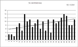
In general, identifiable plant macrofossils (primarily fruits and seeds) were rather sparse in these deposits, both in terms of numbers of taxa and numbers of fossils, though with something of a trend of decreasing diversity upwards through the sequence, as shown by a linear regression applied to a plot of the values for 'number of identifiable taxa' (as recorded in Table 3, and shown as a plot in Figure 14). In fact the values for this vary greatly from sample to sample and this may well reflect the proportions of bulky material (wood and twigs) and/or the somewhat variable degree to which the peat was disaggregated. Preservation was almost entirely by anoxic waterlogging, though there were some small amounts of wood charcoal (particularly through the middle part of the sequence, which was where the bulk of the records for other charred remains – culm, other herbaceous fragments, and fruits and seeds – tended to fall). A few angular concretions, which seemed to consist of pyritised amorphous organic material, were noted, again mainly in the middle levels.
With regard to the evidence for vegetational and therefore habitat change in the catchment represented by these detritus peats, the most striking patterns are the decline in birch beyond the lowest third or so of the samples (it is almost absent above BL40), though aspen remains a constant throughout. We can be fairly sure that the Populus identified was aspen. Although the greatest number of Populus remains were isolated buds or bud-scales – which could not be identified as to species – it seemed likely that the material was from aspen, P. tremula, on grounds of likely habitat in the vicinity of the site and the previous identifications by Dark (1998). In the event, some catkin scales (and immature catkin buds) were noted which were definitely aspen, marked by their deeply laciniate morphology.
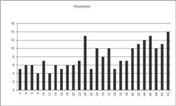
'Woodiness', as a combination of records for identifiable tree parts (fruits, scales) and wood, bark and charcoal, shows an overall downward trend upwards through the sequence (Fig. 15) but this is probably just reflecting the overall decline in diversity of taxa upwards.
Plants of open water – here only water-lily and pondweeds – tended to be more frequent in the lower half of the sequence (particularly present in zones 6, 5 and less so in 4 and 3), their rarity higher up perhaps reflecting natural succession in which trees and other tall vegetation became more dominant in this lake-edge habitat and shaded out the aquatics. This is described by Walker and Godwin (1954, 37), in terms of a classic hydroseral succession, on the basis of transects of borings in this area – though the absence of detailed analyses of plant macrofossils in their study means that a close comparison with the results here cannot be made. It is thus difficult to assess how far the abundance of remains of trees and shrubs in the fossil record of the detritus mud/peat at an early stage as seen in the block (and other) samples from these trenches reflects proximity to the shore (if Walker and Godwin concentrated on deposits rather further from the lake edge, where open water presumably remained predominant for much longer) and how far the lack of evidence for macroscopic remains of trees in the muds reported in 1954 is down to lack of adequate analyses. In particular, the absence of a pollen record for Populus (it is notoriously difficult to recognise and may not have been recorded by pollen analysts at this early date) means that the importance of this tree in the sequences currently being investigated cannot be compared in any way to Walker and Godwin's analyses. The record of 'cf. Populus sp.' in Walker and Godwin's list of macrofossils (1954, 59) does not specify the part recovered but it seems unlikely it could be anything other than bud-scale material.
On the other hand, Dark's (1998) analyses of lake-edge deposits give useful comparanda and her sequences (cf. her figs. 11.4, 11.9, 11.14 and 11.19) sometimes clearly show a record for aspen catkin scales and Populus bud-scales continuing to be quite well represented after birch has disappeared from the record. It has to be remembered, though, that the samples examined by Dark were from tiny amounts of peat (5-10 ml, ibid., 125) and that there is a x10 exaggeration in her histograms (although the distinct decline in numbers of both taxa and remains, seen in the 2007 block, is clear from the upper two-thirds of all the diagrams). A particular problem is that, while the small macrofossils of birch and aspen may well, as she suggests, have floated, the failure of her sampling methodology to allow for the presence of twigs and fragments of root or stem wood means that the prevalence of these at many levels in the 2007 block cannot be matched in her histograms (though wood is mentioned in the sediment descriptions she provides as being present in some parts of the stratigraphy).
The aquatic-marginal and fen/reedswamp taxa show no particular readily interpretable pattern for individual taxa, their records being scattered through the sequence, but with a distinct peak in numbers of taxa through BL14 to 18 (Fig. 16), and contrary to the decline in diversity overall upwards through the sequence (Fig. 14). These are three of the levels at which charred reed remains were recorded and it may be that some opening of the canopy through fire damage resulted in a short-term renewed growth of fen and waterside plants.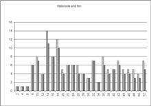
In sum, although reconstructions of the environment have been carried out previously, the analysis presented here provides a slightly different perspective. The first examination of the environment was carried out by Walker and Godwin (1954) and although this provided an important picture, the resolution was low compared with modern-day pollen analysis and, as already mentioned, missed Populus. The work carried out by Cloutman and Smith (1988) improved the understanding of the environment of the area, with extensive contour surveying and pollen analysis. However, as mentioned by Dark (1998), the resolution was 1-2cm and to understand human activity it needed to be finer grained, which was why Dark carried out further study at a 1-2mm resolution examining pollen, micro-charcoal and macroscopic plants. This provided a much more detailed picture; however, as mentioned above, the study was based on very small samples and the larger twigs and fragments of stem and root wood were not considered. Therefore, this macroscopic plant analysis from the block has particularly allowed a more detailed picture of the small pieces of wood.
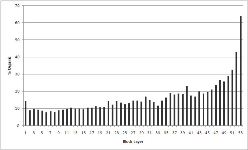
The loss-on-ignition results give a fine-grained view of the organic component of the block. The results clearly show that at the base of the block there is a higher level of inorganic material which correlates with zone 6 samples where there was a mixing of the glacial clay with the twiggy detritus (Fig. 17). There is a slight peak in sample 41 and this is also observed in the sediment analysis (Table 2), layer 42, where it is noted that the peat was rather silty, possibly more than other layers, and there is a likelihood of inwash at this point. There is a similar correlation for the observations made for layers 30-31, where it is noted in the sediment observations (Table 2) that there is a silty detritus and again there is a very small peak in the loss-on-ignition results. The possibility of inwash may indicate some disturbance and erosion of a bank at the edge of the lake that may be related to human or animal activity. However, from the archaeological evidence it is likely that there was significant activity in this region at various points but especially when zone 3 (layers 15-28) deposits formed, and this has not produced any significant pattern within the loss-on-ignition data.
© Internet Archaeology/Author(s) URL: http://intarch.ac.uk/journal/issue28/2/4.html
Last updated: Thu Mar 25 2010