The pre-fortress settlement at Aggersborg comprised post buildings together with sunken-featured buildings. Artefacts associated with these buildings indicate that settlement commenced at the site in the last quarter of the 8th century or around AD 800, and continued until the construction of the fortress in the late 10th century. In many respects this settlement has the appearance of an ordinary rural settlement, yet it demonstrates a very high density of activity and unusual organisation.
The artefact material comprises a large body of common domestic object types, including a large body of pottery (c. 29,500 sherds), iron tools, weapons and fittings, glass beads, antler combs, and a small collection of jewellery, ornaments, and coins. There are a large number of textile tools, while traces of more specialised crafts, namely refuse from bone-, antler- and metalworking, were found only rarely. Evidence of long-distance contacts includes a few objects from western Europe (fragments of Mayen Lava quern stone, a few pieces of Tating-ware ceramics, an early 9th-century Christiana religio coin, occasional sherds of glass vessels) and from the British Isles (a mount, a strap-end and a jet bead) (Roesdahl 1986a; Pedersen 2014). These finds are more than matched by an unusual quantity of Norwegian imports: almost 25kg of soap-stone vessels, and hones, including many of Norwegian dark grey siltstone or light grey Eidsborg schist (Mitchell et al. 1984).
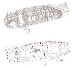
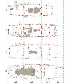
From the excavations, at least a dozen post buildings from the pre-fortress settlement are noted. Among these, five are marked out as dwelling-houses by their size (>20m long) and by the presence of a hearth in the central room (buildings A, C, D, F and GS cf. site plan Figure 10). The fine preservation of some buildings reveals detail of the interior organisation, including clay and chalk floors, hearths and paving stones, that is rarely encountered elsewhere in Viking-age Scandinavia (Figure 11).
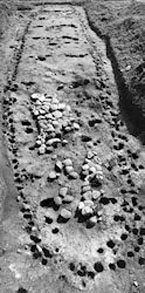
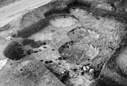
The best-preserved dwelling houses show a remarkably similar organisation (Figure 12). Allowing for incomplete preservation, the houses were apparently built to a traditional plan and system of measurement, probably based on the unit of a fathom, c. 1.8m. A dwelling room was placed in the middle of the house, presumably between a stable or byre in one end of the building and one or two rooms at the other end, one of which had external doors and sometimes a hard floor, and may have been used for the cleaning, drying and threshing of grain. The length of the dwelling room was invariably about 8.8m, equivalent to 30ft or 5 fathoms. It was centred on the fire-place, which took the form either of an open hearth or, at least in houses F and GS, more probably the form of an oven, wholly or partly covered with a clay roof.
One building, house D, located in the area just north of the western gate of the later fortress, is distinguished by its unusual size (40.5m long) and by 'archaic' architectural details, including rounded gables (Figure 13). Unique among the excavated buildings, this house was built and rebuilt three times on the same spot, and appears to have stood throughout the almost 200 years of the settlement. The building is also associated with exceptional finds: a gold arm ring, found coiled together and hidden in the top fill of a principal post, sherds of glass beakers and a rock crystal bead. These factors would seem to indicate a special status for this house.
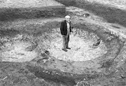
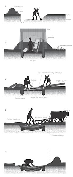
Together with the post buildings were a large number of sunken-featured buildings (or SFBs): small sunken structures of circular or rectangular form with two, or sometimes four, roof-bearing posts (Figure 14). The walls of the buildings were defined by the sunken area and were raised by the addition of turf and earth from this pit (Figure 15). The roof was normally constructed on a ridge-beam carried by two gable-posts. Aggersborg was the first site in Scandinavia where these buildings were identified. SFBs were a universal type of structure in settlements from the Late Iron Age to the Viking Age in South Scandinavia. In various forms they appear throughout most of northern Europe (Hamerow 2002, 31-5). Easy to build, and, because of the efficient insulation provided by the enveloping earth, easy to heat or keep cool, they could be used as store-houses, craftsmen's workshops, seasonal dwellings, etc. Several loom weights were noted in the bottom layer of a number of buildings (nos 273, 290, 292, 615, 1144, 1147, 1149 and 1157), suggesting that weaving formed part of the activities associated with these buildings. Traces of other crafts or activities were only seen very occasionally, and do not appear to have formed a regular part of the activities pursued in SFBs at Aggersborg.
As the most substantial dug features relating to the pre-fortress settlement, the fill of the SFBs is critical to the interpretation of the results of the geophysical prospection. In excavated SFBs variation in the fill generally correlates with the character of the soil into which the buildings are dug. In most cases, therefore, the bulk of the fill is apparently material from the immediate surroundings of the pits, presumably often the same soil that was first dug from the pit, and which had formed an earth wall around the building.
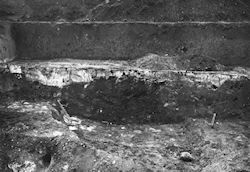
Distinct layers in the fill were seldom noted, whence it would seem that the SFBs were normally filled in a single event or over a short period. Where stratigraphy is documented, they appear to consist of settled layers (Figure 16).
Abandoned SFBs may have acted as rubbish dumps, but the number of recovered artefacts is modest considering the fact that all soil from the great volume of fill was sieved and preservation was reasonably good. As for pottery (by far the most common group of finds) only a fifth of the buildings contained more than 50 sherds. Animal bones were noted in some quantities, while other artefacts amount almost exclusively to occasional common domestic object types. This suggests that the finds are mostly accidental losses related to activities in the buildings or in their surroundings.
A small number of SFBs showed a more varied fill, such as wind-blown or washed-down sand (nos 120 and 919). In about a dozen SFBs the descriptions mention greasy black humus or horizons of clay or chalk. These may relate to dumping, but could also be deposits of floors or cultural layers that have sunk into the fill as the layers have compressed (Figure 17). In four SFBs substantial charcoal layers are reported in the upper fill layers: no. 2032, in which the charcoal must be a conflagration layer relating to a house (house GS at coordinates [-170m, -70m]) that later covered the building; and nos 244, 290 and 356, which share a position adjacent to the inner face of the rampart and suggest that a fire consumed the wooden constructions of the rampart.
Some 150 such buildings were excavated at Aggersborg (135 certainly identified, together with 16, probably of the same form, which were disturbed or not fully excavated). Their distribution was highly uneven within the excavated areas. The greatest concentration was within the fortress area, in a belt within the east gate and eastwards outside the fortress. Few were found north of this area and to the south they were more scattered. They were also sparse in the western part of the fortress area, but a cluster was recorded in trial-trenches somewhat to the west of the fortress.
It is clear that few if any of the SFBs were contemporary with, or related to, the fortress. Forty-nine excavated SFBs coincided with features in the fortress and, therefore, must be either older, or – in a few cases – possibly younger than them. Most of the remainder are either located outside the fortress, or in positions that would seem unlikely to form part of the tightly structured fortress layout.
Observations suggest that the character of the pre-fortress settlement shifted during the c. 200 years of occupation: while several SFBs contain artefacts that date from the earliest settlement around the beginning of the 9th century, most of the post-built houses (houses A, C and GS) are clearly later, as their posts cut earlier SFBs or other features. Even if other houses (houses F and XB) may be earlier, they are too few, considering the life expectancy of a post-built wooden building, to indicate permanent occupation by several farms for 200 years. Among the excavated post-built houses, only the large house D can plausibly be argued to have formed part of the earliest phase of the settlement, covering no earlier remains and having been rebuilt repeatedly. Over the course of the 9th and 10th centuries the settlement develops with the addition of several houses, presumably the main buildings of individual farms, together with a number of SFBs and other farm buildings. This pattern is consistent with that known from other contemporary rural settlements in Jutland (Mikkelsen 2006). It may be suggested on that account that the settlement originally consisted of a single large farm, centred on house D, with one or several areas with SFBs; it gradually developed into a nucleated settlement of several households in which, however, house D still marked its owners as being of special status.
Three buildings show evidence of violent destruction in the late 10th century. In building GS, a thick layer of charcoal, charred timbers, burnt clay and other burnt material had sunk into the top of an earlier pit along the south wall. A sherd of early Baltic ware pottery found on the chalk floor near the central hearth dates the last phase of use within the period c. AD 970-1000. Building A, which was partly covered by the fortress rampart, was similarly associated with a layer of charcoal, and two fire-marked stones of a rotary quern were found bottom up but still pressed together, presumably left as they fell. Sherds of Baltic ware pottery found at the southern wall of this building again indicate a date in the late 10th century, albeit the association is less certain than for house GS. The features of the large house D, also partly covered by the fortress rampart, were covered in a greasy, charcoal-rich layer, and a wooden frame lining the central hearth was completely charred. No closely datable materials were found, although the gold arm ring belongs to a type mainly found in the second half of the 10th century; but it was noted that the earth fill of the rampart rested immediately on top of the charcoal layer. It is almost certain, therefore, that the settlement existed until the fortress was built, and was cleared prior to its construction.
The finds from the excavations indicate that settlement was not re-established on the site after the abandonment of the fortress. However, finds from a few features to the west of the fortress point to limited continuation of activity. In SFB nos 2018 and 2029, sherds of Baltic ware pottery were found, while in the bottom layer of SFB no. 2019 a German coin was found belonging to the 'wooden-church type', minted in Speyer c. 1000/1005-1045 (Moesgaard and Jensen 2014). While Baltic ware pottery came into use during the later decades of the 10th century, and so could have reached the site prior to the construction of the fortress, it is more commonly found on 11th-century sites (Roslund 2007, 166ff). The coin is certainly later than the construction of the fortress.