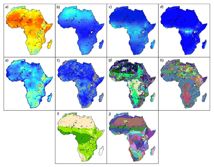
Many studies of primate and hominin biogeography focus on patterns at the largest, i.e. multiregional or continental, scales (e.g. Bromage and Schrenk 1995; Cote 2004; Folinsbee and Brooks 2007; Heads 2010; van der Made 2011). Mapping landscape spatial structure at this scale (Figure 3) showed that patterns here are relatively simple, with only a few basic spatial structures visible in the variables studied.
There are different basic patterns apparent in the three broad datasets identified in Table 1. The climatic variables (Figure 3a-d) all show variations on a basic latitudinal banding pattern. For annual mean temperature, temperature seasonality and annual mean rainfall there are three bands, one covering the Sahara (from the north coast down to about 10°N), another from 10°N to ~15°S, and a third and final band covering the area between 15°S and the southern coast. The three bands, from north to south, are characterised by the following conditions:
The banding patterns are clearest in the temperature seasonality dataset (Figure 3b) and slightly fuzzier in the annual mean temperature (Figure 3a) and rainfall (Figure 3c) maps, with these latter two datasets showing a few coastal and terrain effects in the East African highlands and along the western coast.
The rainfall seasonality map (Figure 3d) also shows latitudinal banding, but the central band – delineating the area with highly seasonal rainfall regimes – is much narrower, extending only between ~5°N and ~2.5°S at its widest point.
The physical landscape variables (Figure 3e-h), in contrast, show very little latitudinal banding and, instead, are dominated by patchy, irregular patterns. There is no visible banding at all in the topography and terrain roughness data (Figure 3e-f), which instead show patterns that highlight the landscapes of the East African highlands, the Rift Valley, the Atlas and Drakensberg mountains and high-altitude areas of Angola and Namibia.
Interestingly, there is a fair resemblance between the patterning in topography and that in topographic roughness, but the match is not exact: not every high-altitude area is also very rough (compare the Ethiopian highlands, which are high altitude and very rough, and the high-altitude areas in Angola and Namibia, which are only moderately rough), and some low-altitude areas are not smooth.
The maps of soils and surface geology (Figure 3g-h) show some of the same features as the terrain maps but also have some areas that show weak latitudinal banding and others where the pattern is not banded but does not consistently map onto terrain either. The two also do not map very neatly onto one another. In the very south, for instance, the Drakensberg mountains, clearly visible both on Figures 3e and 3f, are visible on the map of surface geology (Figure 3h), but not on the soil map (Figure 3g), while the sides of the East African Rift valley, also apparent on both terrain maps, barely register on the former but are clear on the latter. Overall, all four of these physical landscape maps differ in their spatial structure from the climatic maps, and they all have irregular patterns, but they do not form such a coherent group as the climatic maps.
Finally, we can look at the vegetation and ecoregion maps (Figure 3i-j). For vegetation (Figure 3i), we see some latitudinal banding, particularly in the north and west where there are more bands than on the climatic maps. The edges of these vegetation bands do not, however, map especially clearly onto those on the climatic maps. The rest of the vegetation map is more complex, with patches of different vegetation, some of which may be related to terrain features or particular soil/geological units, and little banding. The ecoregion map (Figure 3j) reflects some of the same latitudinal banding but with more east-west divisions, delineated presumably by areas of endemism and particular ecosystems' limits. On this map, there are again latitudinal bands in the north, but strikingly few in sub-Saharan Africa, where the pattern is patchier. The two vegetation-related variables, then, show evidence of some influence from climate – particularly in the north and west – and some from the physical landscape, particularly in the east and south; they are essentially intermediate in their overall patterning.
Overall, then, we can identify two broad landscape patterns at the continental scale, namely latitudinal banding, which dominates climate maps and irregular patterning, which dominates the terrain variables and (to a slightly lesser extent) soil and geology. Both are visible in the vegetation and ecoregions maps, which might be classed as intermediately patterned.
Internet Archaeology is an open access journal based in the Department of Archaeology, University of York. Except where otherwise noted, content from this work may be used under the terms of the Creative Commons Attribution 3.0 (CC BY) Unported licence, which permits unrestricted use, distribution, and reproduction in any medium, provided that attribution to the author(s), the title of the work, the Internet Archaeology journal and the relevant URL/DOI are given.
Terms and Conditions | Legal Statements | Privacy Policy | Cookies Policy | Citing Internet Archaeology
Internet Archaeology content is preserved for the long term with the Archaeology Data Service. Help sustain and support open access publication by donating to our Open Access Archaeology Fund.
File last updated: Wed Mar 4 2015