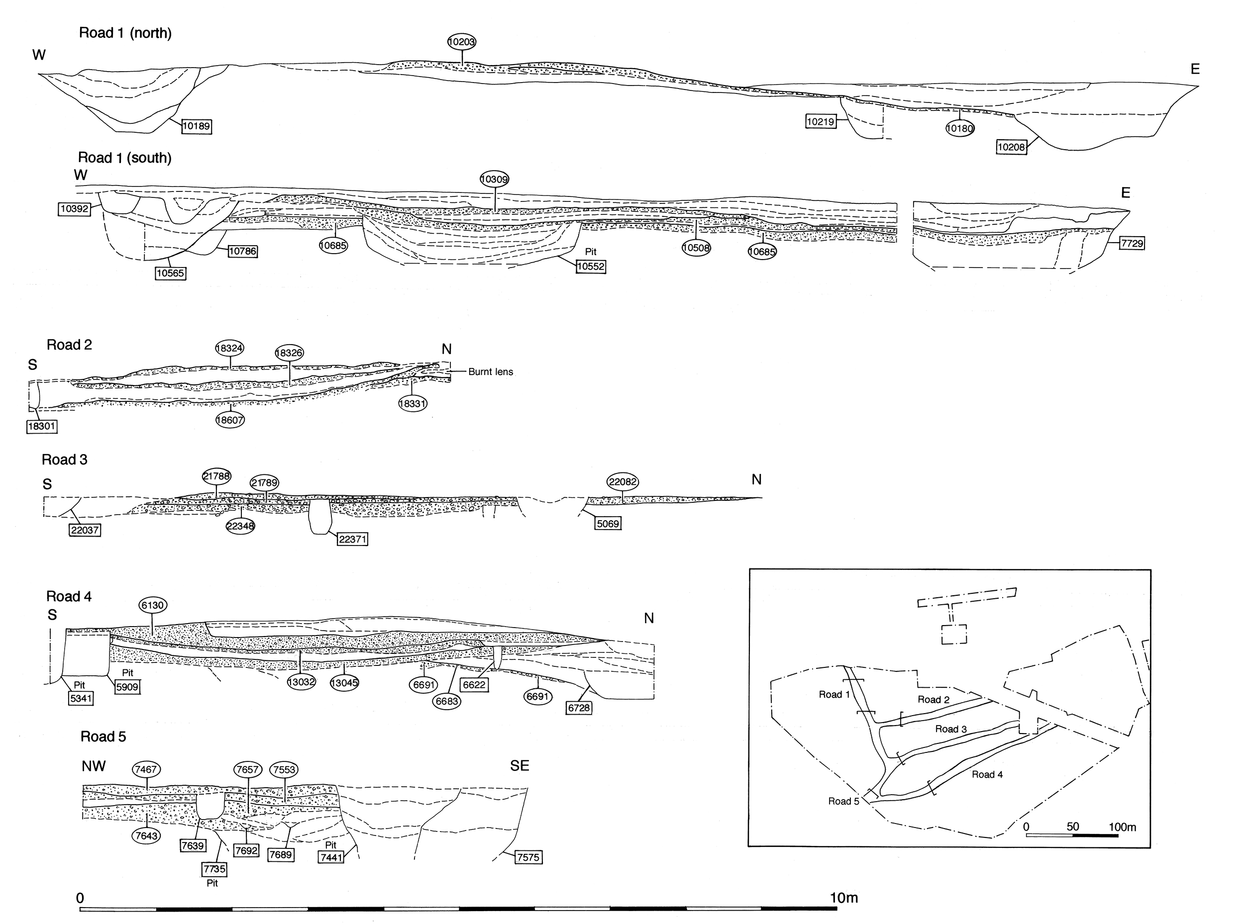
Road 4 (Figure 6 and Figure 58), along with Roads 3 and 5, is one of the side roads that extend eastwards from the principal thoroughfare of Road 1. It is assumed that it is created as an integral part of the LIA/early Roman transition period remodelling of the settlement and the imposition of its infrastructure.
However, the only clear evidence for the existence of Road 4 in Period 2B is concentrated at its western end, and much of its overall course is conjectured from later ditch alignments (25078 Period 6) and an absence of intrusive Period 2 and 3 features along it. The road may be 5-7m wide, but is likely to have an undefined southern edge and to merge into the gravel-surfaced interior of Open Area 17 alongside it.
Encountered within Areas H and L, the Road 4 deposits and associated features of Period 2B date are described from west to east.
Road 4 was investigated in a series of trenches along the south side of the western end of OA19 (in Excavation Area H), where compacted gravel deposits 6425, 6476, 6683 and 6691 (Group 133) represent a metalled road surface laid directly on natural gravel and sand. The surface is exposed only over the northern half of the 4m road width, but this is sufficient to reveal a clear camber, with a 0.26m drop from the middle of the road to its north edge. There is no artefactual material evident in these investigated deposits.
The northern side of Road 4 is flanked by 1.5m wide, 1m deep cut 25255, with a U-shaped profile (seg. 6938). As it is only exposed within a small 2m wide trench, the eastward continuation of this feature cannot be reliably identified, but it may represent the earliest roadside ditch. It contains only a small quantity of pottery and bone, a spindlewhorl (SF5644) and a loomweight fragment (SF8433). Its lower fill appears to be late Iron Age, though its upper fills includes mid/later 1st century material. It is sealed by the make-ups (Group 195) for Building 16.
The relatively thin primary surfaces of Road 4 are probably short-lived. They are replaced by a far more substantial resurfacing (Group 135), represented principally by deposit 6671, a 0.22m thick sandy gravel surface, to which 13076 and 13077 are probably equivalent. Although truncated by later resurfacing activity where it rose toward the centre of the road, it is assumed that this is a resurfacing of constant thickness across the whole width of the road, preserving the extant cambering of this thoroughfare. As it is truncated by Period 3 ditch 25254, the full northwards extent of road surface 6671 is unknown, although a northwards shift or general widening of the road is suggested. While 6671 is clearly a distinct surfacing episode, it still appears to be of transitional date although there is little tangible dating evidence to clarify this; its single tiny sherd of Romanising greyware scarcely constitutes a secure basis for dating. The next surface above it dated to the late 1st century (Period 3).
It is possible that Road 4 is also in evidence further east, in Excavation Area L, where a sandy gravel layer 20706 (Group 136) overlies OA17 interior surface 20759. Although only investigated within a 2m wide trench across the roadline, this 0.08m-thick compacted deposit has a south edge that follows the prevailing east-west alignment of Road 4. The deposit extends 12m north-south, with a distinct northern edge, but may represent the construction of a formal roadway between OA17 and OA19. As the surface overlies the enclosure interior surfacing, rather than merging with it, this deposit is interpreted as a resurfacing. However, this far east of the main road system Road 4 may have been little more than a track through the adjoining gravelled open areas.
Beyond Excavation Area L, some 90m east of the junction with Road 1, there is no evidence of further metalled surfaces on the line of Road 4.
Internet Archaeology is an open access journal based in the Department of Archaeology, University of York. Except where otherwise noted, content from this work may be used under the terms of the Creative Commons Attribution 3.0 (CC BY) Unported licence, which permits unrestricted use, distribution, and reproduction in any medium, provided that attribution to the author(s), the title of the work, the Internet Archaeology journal and the relevant URL/DOI are given.
Terms and Conditions | Legal Statements | Privacy Policy | Cookies Policy | Citing Internet Archaeology
Internet Archaeology content is preserved for the long term with the Archaeology Data Service. Help sustain and support open access publication by donating to our Open Access Archaeology Fund.