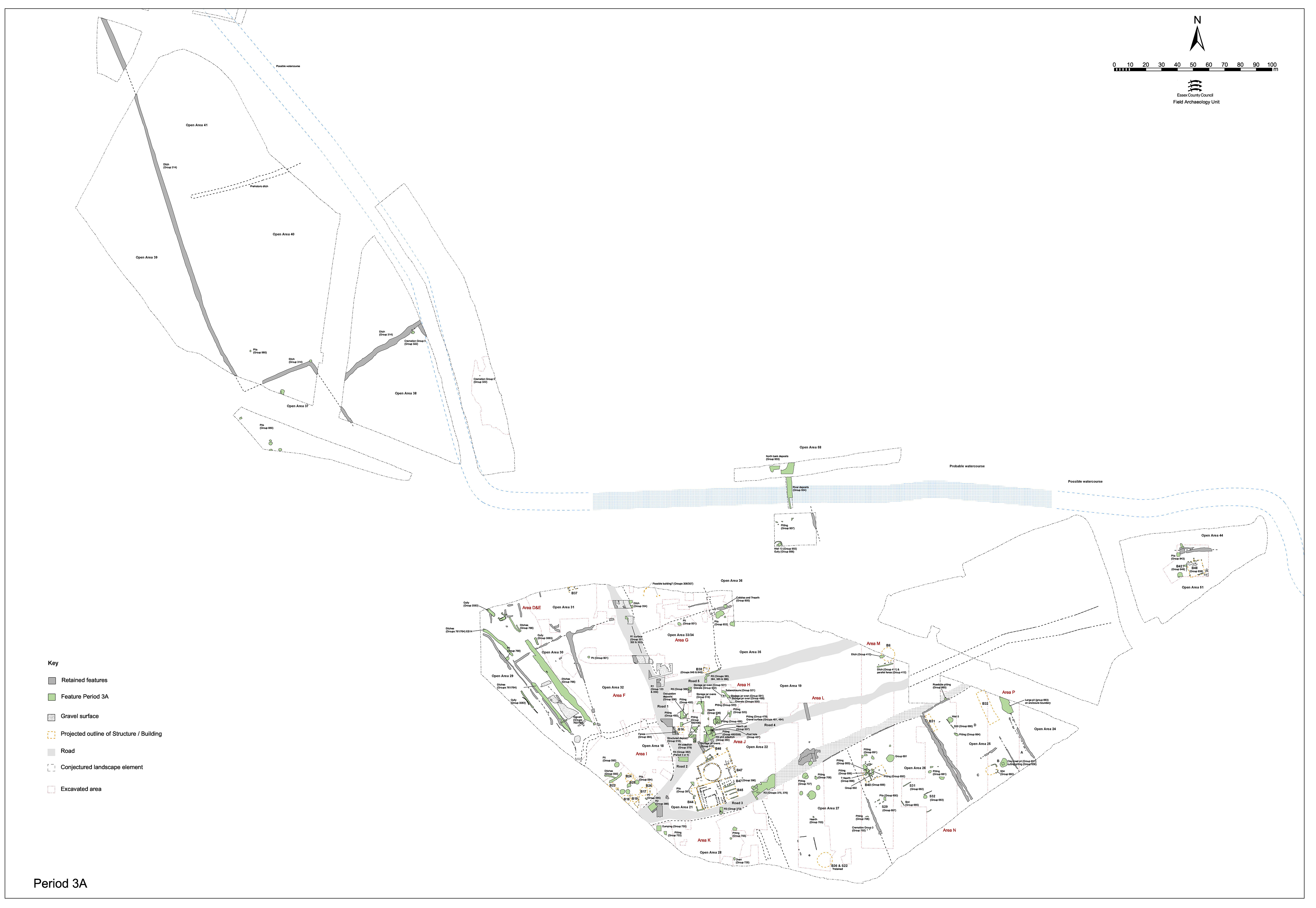
Road 1 (Figures 69-70) undergoes two distinct episodes of resurfacing in Period 3, as deduced from deposits recorded in trenches excavated across it in Excavation Area F - primarily in the 'Haul Road' and 'North' Trenches, towards the northern end of its traced extent. This road surface maintenance is accompanied by replacement and/or cleaning of roadside ditches. Both road surfaces and flanking ditches are described here.
Haul Road layers 10180, 10203 and 10227 (Group 352) are bonded gravel surfaces that, incorporating the existing Period 2B road surface 10210 (Group 126), form a substantial road some 8m wide. These deposits slope gently to either side and suggest a deliberately cambered road surface. They overlie silty sand layers 10592, 10598 and 10626 (Group 351), probably accumulations rather than deliberate make-up deposits, on top of the earlier Period 2B road surface. These accumulations presumably represent build up during use. While 10592 contains only Late Iron Age pottery, the others include occasional tile fragments and early Roman pottery. The metalled surface above them should therefore be early Roman. Period 3 metalled surface 10574 (Group 352) seals the fills of earlier roadside ditch 25038 (Group 124 Period 2B) and signals a deliberate widening of Road 1 at this point.
North Trench deposit 10508 (Group 353) is a 0.1m thick, compacted, gravel surface that seals the former roadside ditch 10546/10582. This continues the widening of Road 1 as seen in the Haul Road area. The road at this point is in excess of 7.5m wide and clearly conforms to the prevailing NNW-SSE alignment. Layer 10511 (Group 353) is a very thin silty gravel deposit on top of the metalled surface and may be a weathering deposit (not obvious in section).
Roadside ditch 25246 (segs 10206, 10208 Group 354), revealed in the Haul Road trench, runs down the east side of Road 1 and truncates the east edge of earlier roadside ditch 25038 (Group 124 Period 2B). It is 2.6m wide and c. 0.6m deep with steep sides and a broad, flat base. Though only revealed for a short distance, where obscuring silt deposits were removed, it appears that this ditch is a direct replacement of 25038. It must be associated with metalled surface 10180, with this eastward shift of the ditch facilitating the widening of Road 1, as described above. The single dark brown gravelly silt fill contains pottery of the 1st century AD, albeit mainly on the early side, and animal bone.
Although it was not established if this replacement east-side ditch is present alongside that part of Road 1 investigated in the Area F North Trench, ditch segment 7749 (Group 354), further south in Excavation Area G, is probably a continuation of ditch 25246, although too little of it was revealed to add much further detail. It is at least 3m wide and 0.4m deep. Although only revealed in a 1m-wide slot, it clearly runs parallel to the road. It appears to be deliberately backfilled by the later 1st or early 2nd century AD, and then overlain by a later episode of road widening or shift. While the date of its creation is not established, it is speculated that the eastern roadside ditch therefore extends down Road 1 as far south as its junction with Road 5.
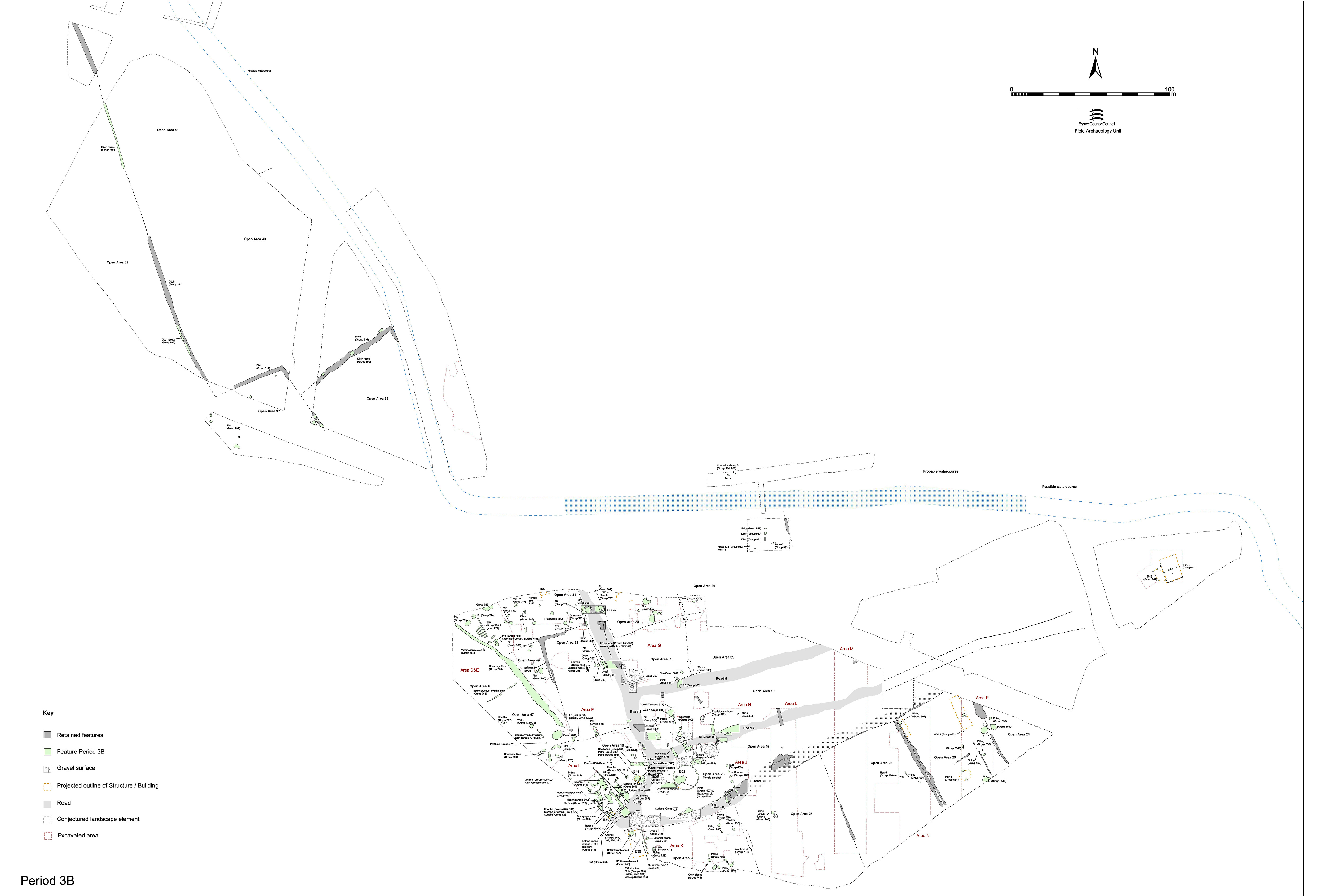
To the south of its junction with Road 5 (i.e. where investigated in the Area F South Trench or in Area H), there is no evidence that Road 1 is resurfaced in this early Roman period. The Period 2B surface (Group 130 Road 1 ph 1/2) is, however, clearly still in use. In the absence of formal repairs, Road 1 continues in places to subside into underlying Late Iron Age features (e.g. Period 2A waterhole 6734). Within this hollow, brown silts 6450, 6648 and 6380 (Group 363) accumulate as late as the mid-2nd century. These silts are cut by slots or gullies, with stake-holes alongside, which probably mark a fenceline (Group 364) along the roadside. The stake-holes are all more-or-less identical, 10-15cm in diameter and 9-15cm deep. The slots are of similar depth, and slot 6512 has stakes driven through its base. The irregular line of 6512 requires some explanation. This irregularity alone seems to rule out any possibility of these being part of a building fronting the road here. It is possible these features demarcate the slumping area of Road 1 (underlying hollow 6734 causes every surface above it to slump, it appears), prior to continuing repairs above them, but it seems more likely they just denoted a roadside fence. However, there is a suggestion that build-up layer 6380 (Group 533) may accumulate up against and behind this line, so that these features would mark a revetment for this 'bank'. Just possibly the pressure of this bank could explain the line of 6512, as the revetment buckles under the strain. Later road surfaces reclaim this space and cover over the area.
Within this wear and subsidence hollow are also traces of what were recorded as irregular ruts, 6470 and 6512 (Group 364). However, three apparent stake-holes are recorded within 6512 and it remains possible that both ruts are in fact structural slots. In section, 6512 could perhaps be construed as the remains of a wall or fence against which 6380 could accumulate (Group 364).
A western roadside ditch is represented by ditch 25244 (segs 10189, 10522, 10565 Group 360), encountered in both the Haul Road and North Trenches of Excavation Area F. It varies between 1.6m in width at the south to 2.4m to the north and 0.6-1.0m in depth, apparently draining northwards (perhaps ultimately into the watercourse?). It contains a sequence of gravelly and sand-rich fills - largely material washed from the adjacent road surface. As excavated, this ditch has no direct stratigraphic relationship with road surface 10309. However, as it cuts the underlying preparation deposits and, further north, cuts surface 10185, it is likely that this ditch post-dates Period 3 surface 10309 as well. It is nonetheless likely that they are contemporary in their subsequent use.
The artefact assemblages within the fills of the ditch and its successive re-cuts (see 25245, below) suggest continuing occupation in the vicinity of Road 1. While much of the ditch fill material derives from the road itself, the fills also contain fairly typical assemblages comprising large amounts of pottery together with tile, daub and animal bone.
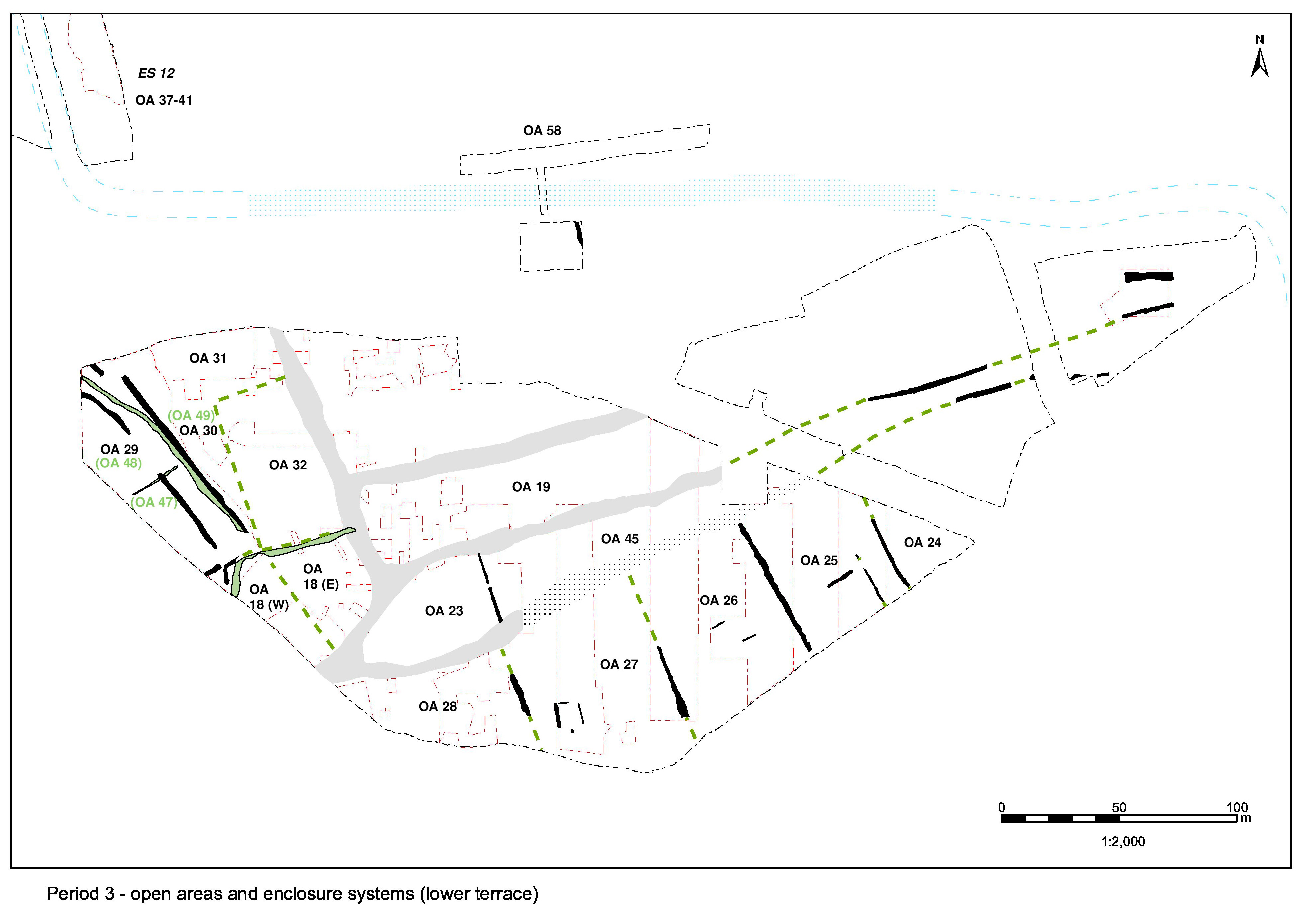
No earlier ditch along the west side of any of the preceding road phases has been recognised. It is possible that this edge remains generally static through time and that any such feature is removed by the cutting and re-cutting of 25244 (see 25245, below). Although the ditch is only clearly visible for some 24m in the north and is not visible at all further south until excavated, it is presumed to extend alongside Road 1 for some distance - but apparently stopping short of the South Trench since it was not located here.
The second episode, as identified in the Haul Road trench, comprises clean clay-sand consolidation or make-up layers providing a base for the overlying metalled surface. Make-up deposits 10171 and 10179 (Group 355) overlie the fills of roadside ditch 25246 and seem to be confined to the edges of the road, perhaps in an attempt to level out the camber of the old road. Layer 10169 (Group 355) constitutes the levelling of a subsidence hollow in the surface of the former road. It is clear that the surviving surfacing of the underlying road (10203 Group 352), particularly at its centre, is incorporated into the new road surface (Group 356) and that the new surfacing to each side represents a process of levelling and further enlargement that increases the Road 1 width to as much as 11m in places. However, it is possible that this may be misleading and that the full combined width of old and new road is not actually used, as the peripheries of the earlier surfaces become buried under roadside deposits that even at this early date may already begin to accumulate.
Within the North Trench, the earlier Period 3 road surface is overlain by loose sandy silty gravels 10394, 10395 and 10495 (Group 357). While 10394 is a 1m wide, seemingly path-like, band of cleaner gravel running along the road, the others are largely confined to the subsidence hollows down the middle of the earlier road surface. These deposits may be preparation layers for overlying surface 10309 (Group 358) - a 5.6m-wide expanse of compacted gravel, up to 0.13m thick and bonded in places. Patches of gravel denoting likely repairs are apparent on its surface.
The eastern side-ditch (Group 354), associated with the first Period 3 surfacing, is itself subsequently sealed by several rather scattered remnants of a compacted gravel surface (Group 359) that denote part of the second Road 1 resurfacing in Period 3. It survives most convincingly (as 7686=7744=7757) at the junction of Roads 1 and 5. Exposed across an area in excess of 15m by 10m, this deposit of graded pebbles in a slightly silty-sand matrix, clearly extends to the north-east, off and away from the roads into the interior of Open Area 33. Considerable undulation of the surface is noted, and there are minor local variations in the compaction, both likely to be due largely to the presence of underlying features. Excavation, however, did not penetrate below this level. The full extent of this surface is not established. However, it is likely that gravel surface fragment 7696 (Group 359), alongside Road 1, is part of the same surfacing activity, if not the very same surface. It seems probable that at least this whole corner, and very plausibly considerably more, of Open Area 33 is resurfaced in a single undertaking, resulting in little distinction between road and occupation surface being apparent.
Dating for this event is provided mainly by the features cutting through it, as neither the main surfaces themselves nor features below are excavated. The sparse material recovered from the patchier sections of surface points to an early Roman date (possibly pre-Flavian?). This is apparently earlier than the dating implied by the Road 1 phase 3 ditch that pre-dates some of these deposits. The ditch is infilled in the late 1st or early 2nd centuries. The features that cut the Group 359 surfaces date from the 2nd century and onwards, which corresponds better with the dating of the ditch. It remains likely, however, that Group 359 encompasses a sequence of successive gravels at the south-west corner of Open Area 33 that are in use at the same time as both phases 3 and 4 of Road 1.
There are two re-cuts evident in the top of roadside ditch 25244 (Group 360 Period 3), denoting its continuance alongside the resurfaced Road 1. Both re-cuts are relatively minor and irregular and have been combined as 25245 (segs 10159, 10392, 10529 Group 361). The first, seg. 10392, is 1m wide and 0.3m deep and marks a slight westward shift from the established ditch line, though remaining roughly parallel to it. Within its silt-clay fill is a deposit of unworked septaria 10266. This is likely to be part of a deliberate infill and has a nearby parallel in similar deposit 10278 (Group 796). The second re-cut, 10529, is a 1.2m-wide linear cut, which broadly runs down the centre of 10565. Further south only one re-cut is distinguished (10159), which could equate to either of those in the north, or may indicate that the re-cutting is only sporadic, location-specific, cleaning out. This roadside ditch is probably dug in the late 1st century AD and functions well into the 2nd century.
The artefact assemblages within the fills of the ditch and its successive re-cuts suggest continuing occupation in the vicinity of Road 1. While much of the ditch fill material derives from the road itself, the fills also contained fairly typical assemblages comprising large amounts of pottery together with tile, daub and animal bone. Fill 10182 of segment 10159 across ditch 25245 (Group 361) contains Key Pottery Group 22 (AD 120/5-150).
Internet Archaeology is an open access journal based in the Department of Archaeology, University of York. Except where otherwise noted, content from this work may be used under the terms of the Creative Commons Attribution 3.0 (CC BY) Unported licence, which permits unrestricted use, distribution, and reproduction in any medium, provided that attribution to the author(s), the title of the work, the Internet Archaeology journal and the relevant URL/DOI are given.
Terms and Conditions | Legal Statements | Privacy Policy | Cookies Policy | Citing Internet Archaeology
Internet Archaeology content is preserved for the long term with the Archaeology Data Service. Help sustain and support open access publication by donating to our Open Access Archaeology Fund.