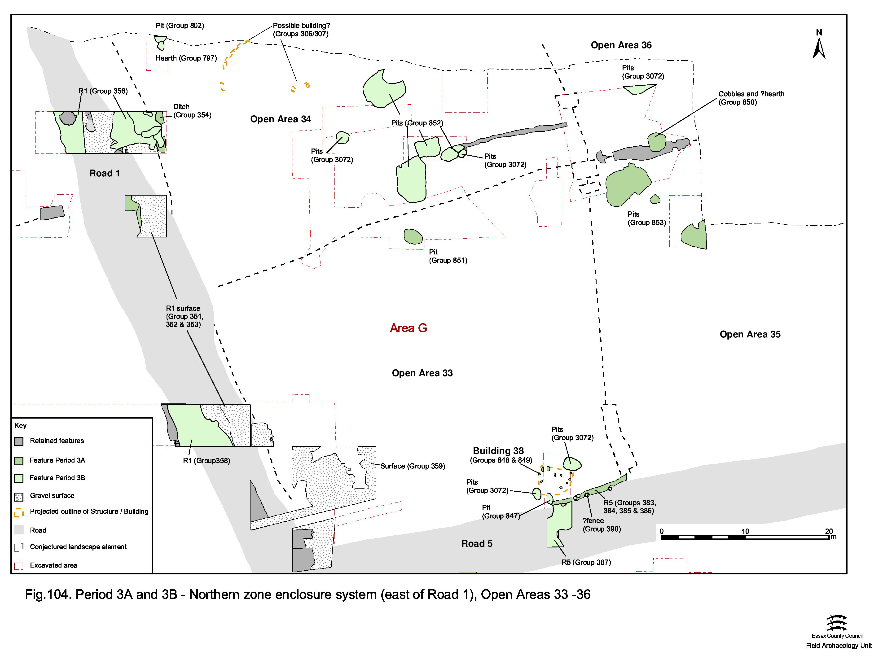
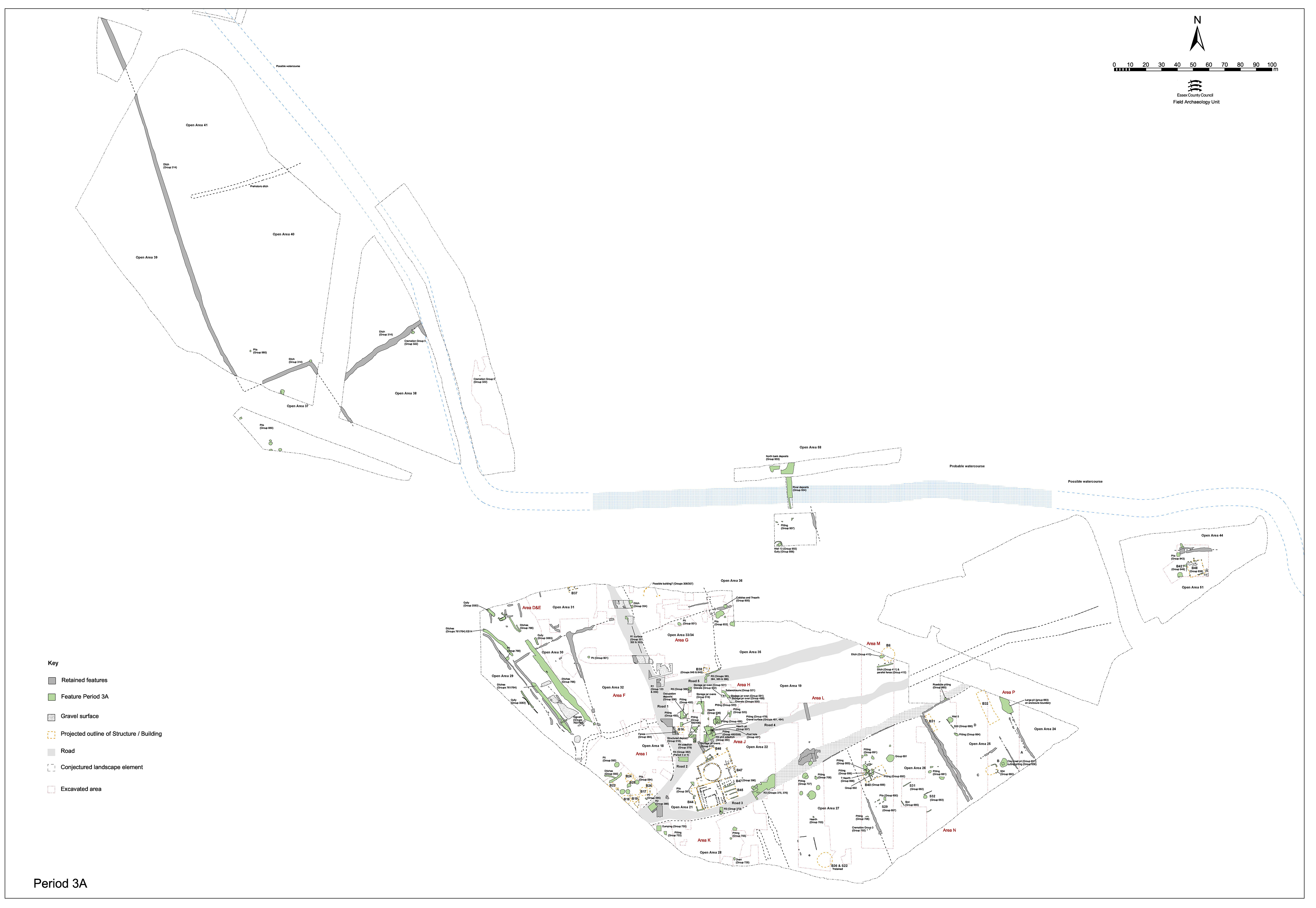
Our understanding of the survival of the Period 2B system of land division into Period 3 within that part of the Northern Zone east of Road 1 (Figure 104) is very poor. It is largely assumed that the ditches defining OAs 33-36, or other forms of delineation replacing them, continue throughout the early Roman period. The majority of investigation of this part of the Northern Zone concentrated on OA33 (within Excavation Area G). The subsequent sections focus on the contents of OAs 34 and 35 as well as OA 36.
Although already discussed as a Road 1-related deposit, some parts of this gravel surfacing are demonstrated to intrude deep (10m+) into the interior of OA33. While the northern and eastern extents of this surface are not determined, it is clear that at the very least it constitutes a substantial and extensive area alongside the Road 1/5 junction, which is evidently not encroached upon by pits or occupied by buildings until at least the mid-2nd century.
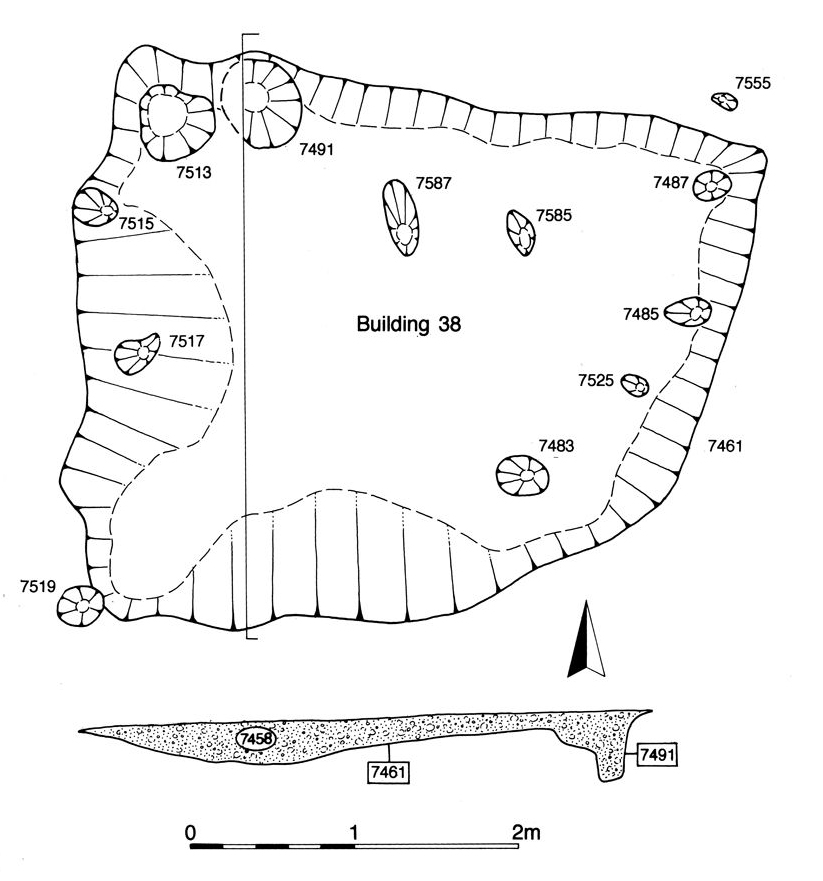
Located toward the south-eastern corner of OA33, Building 38 comprises roughly rectilinear 'hollow' 7461 (Group 848) measuring 4.2 by 3.4m and a maximum of 0.3m deep (Figure 105). Its moderately sloping sides step down to a rectilinear 'depression' occupying the south-west corner of the feature. Arranged around the northern and eastern sides of the depression are ten stake-holes (7483, 7485, 7487, 7515, 7517, 7519, 7525, 7555, 7585, 7587, Group 849) set in its base. Apart from a slightly offset pair, 7585 and 7587, all of these are inclined inward on cut 7461. There is also a larger vertical post-hole, 7491, toward the north-west corner and a small area of burning (7513), probably also in a slight cut. Both these additional features are included as parts of this building.
Although interpreted as a building, it is unclear if cut 7461 represents a deliberately sunken floor or a wear hollow within the structure - perhaps made more pronounced by subsidence of the underlying pit fills. The single large vertical post and peripheral angled stake holes are tentatively interpreted as the remains of a slightly built, almost tent-like, A-frame structure. The lack of daub in and around this feature suggests that its walls are constructed of organic materials other than wattle and daub. The function of this roadside 'bivouac' remains undetermined.
The backfill of this feature largely contains Late Iron Age pottery, plus a small amount of briquetage and loomweight fragments. However, this material is likely to derive from surrounding and underlying Period 2 features (pits 7721, 7722, 7650) and it is the small quantity of Roman material, along with its stratigraphic position along the roadside, which indicate an early Roman date. Poorly dated Roman pits 7480 and 7489 (Group 3072) both cut Building 38.
Early Roman parallels for this structure are elusive.
As relatively little of the OA33 interior is investigated, few pits of early Roman date are recognised. All but one are located alongside Road 5. However, it is apparent that the south-western part of the enclosure, where covered by gravel surfacing, is not occupied by pitting. Consequently, it is conjectured that such activity is confined to its northern and eastern peripheries and away from the junction of Roads 1 and 5.
Oval pit 7139 (Group 851) lies in the northern part of OA33 and could alternatively be regarded as part of the cluster (Group 852) occupying adjacent OA34. Containing a small quantity of pottery, animal bone and slag, it is perhaps notable for the presence of an iron ox goad (no SF number).
Early Roman pit 7575 (Group 847) is positioned close to the northern edge of Road 5 on the southern side of Open Area 33 and again largely contains modest quantities of pottery and animal bone.
Internet Archaeology is an open access journal based in the Department of Archaeology, University of York. Except where otherwise noted, content from this work may be used under the terms of the Creative Commons Attribution 3.0 (CC BY) Unported licence, which permits unrestricted use, distribution, and reproduction in any medium, provided that attribution to the author(s), the title of the work, the Internet Archaeology journal and the relevant URL/DOI are given.
Terms and Conditions | Legal Statements | Privacy Policy | Cookies Policy | Citing Internet Archaeology
Internet Archaeology content is preserved for the long term with the Archaeology Data Service. Help sustain and support open access publication by donating to our Open Access Archaeology Fund.