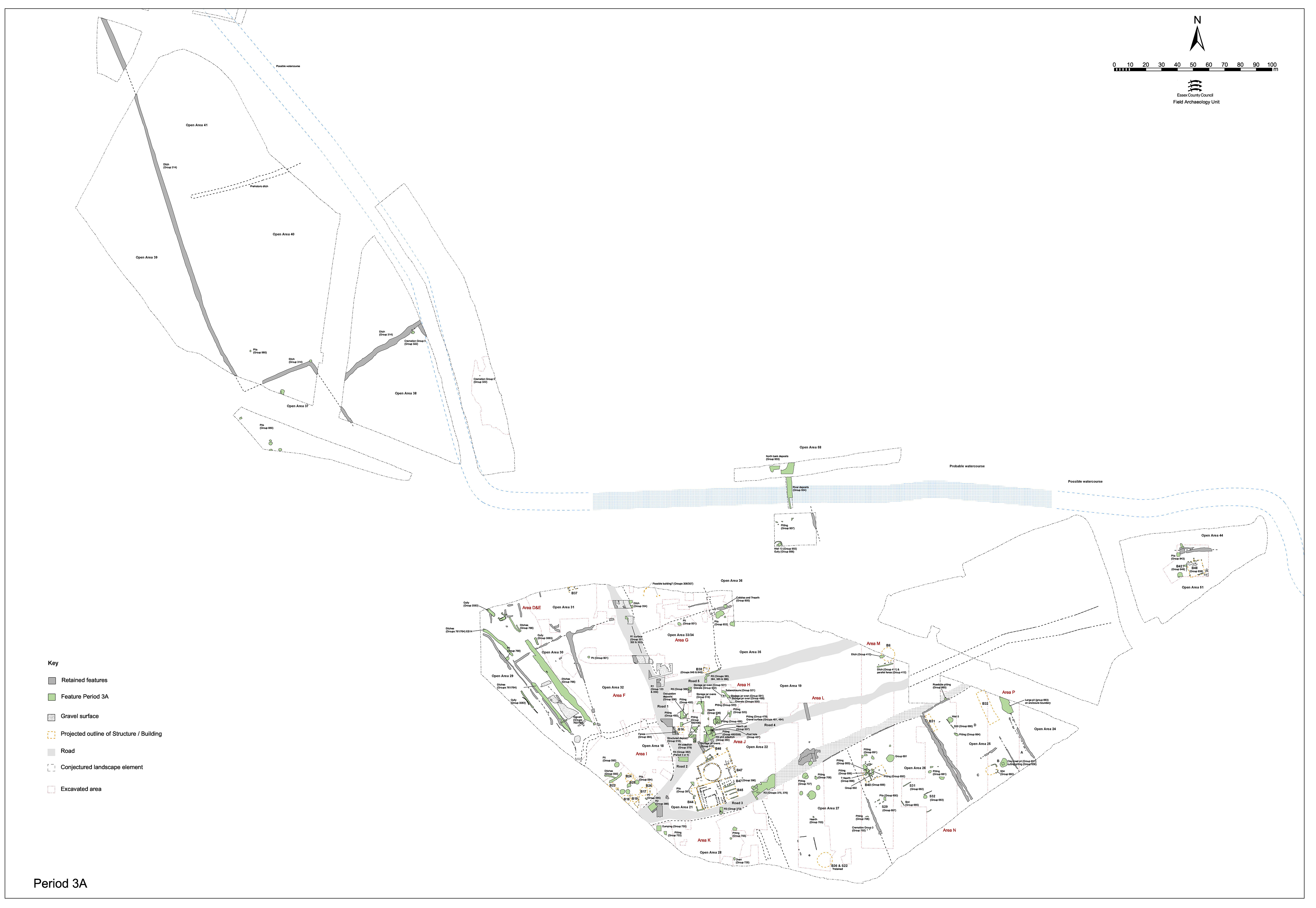
Modification of the enclosure layout of some of the key elements of the Northern Zone enclosure system is carried-out east of Road 1 in the later 1st century AD (Figure 71).
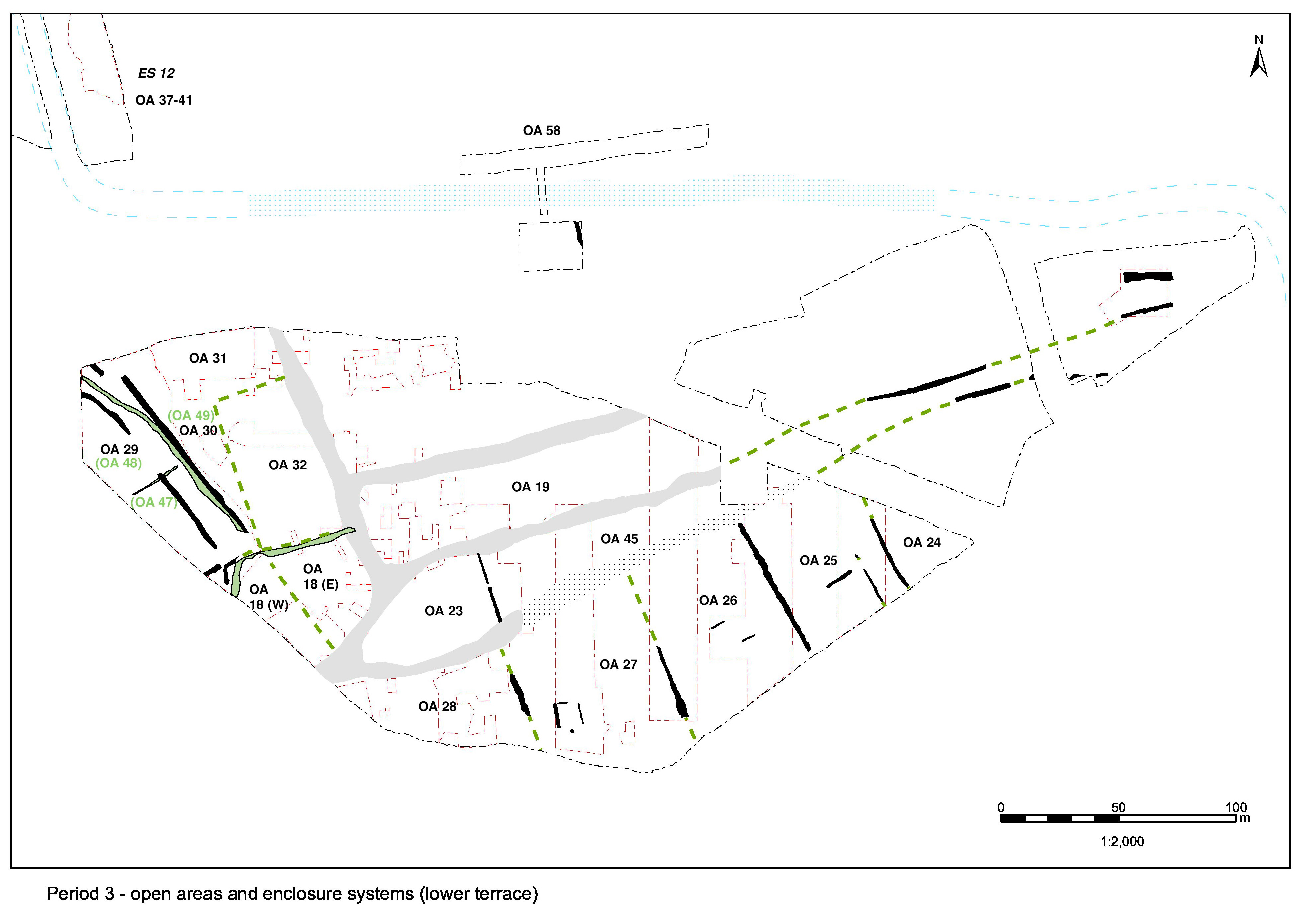
Ditched boundaries 25026 and 25018/25028 are imposed that demarcate either side of a probable wide routeway imposed upon ES9 that conforms to, and perpetuates, the prevailing NNW-SSE alignment evident across the western part of the Northern Zone. As such, they mark the division between OA29 to the west and OAs 30 and 31 to the east, presumably providing access between the central settlement zone and the Northern Hinterland and to the various enclosures in between.
The imposition of this route in some ways represents a simplification of the earlier enclosure boundary configuration at this location (i.e. Period 2B ditches 25016/25017, 25019 and 25020). Despite the change wrought, the new layout respects and incorporates still extant Building 15.
Though offset slightly to the east, 25018 is clearly a replacement of Period 2B ditch 25019, the curve of which it closely mirrors. This displacement seems to be deliberate, in order to establish a single alignment with its counterpart ditch 25028 further south - the west side of OA30 being chosen as the definitive line to follow. It is speculated that this ditch perhaps converges with its predecessor further to the north-west, beyond the limit of excavation. Excavated segment 9213 (fill 9214) contains KPG15, dated to c. AD 50/55-60.
Ditch 25028 is a replacement of the silted-up west side of Period 2B ditched enclosure 25016/25017, more-or-less following 25017 for much of its length and overlying the southern end of 25016 - notably cutting-off the 4m gap in the former arrangement. With a total length of 40m, 25028 is at its most substantial towards either end, reaching a maximum width of 3.3m and a depth of 0.7m. It is possible that it terminates at the same point as its predecessor and that it therefore extends up to the north-east corner of still extant Building 15. Minor re-cuts are recorded within the ditch, showing that it is maintained for some time before its final infilling around the end of the 1st century AD.
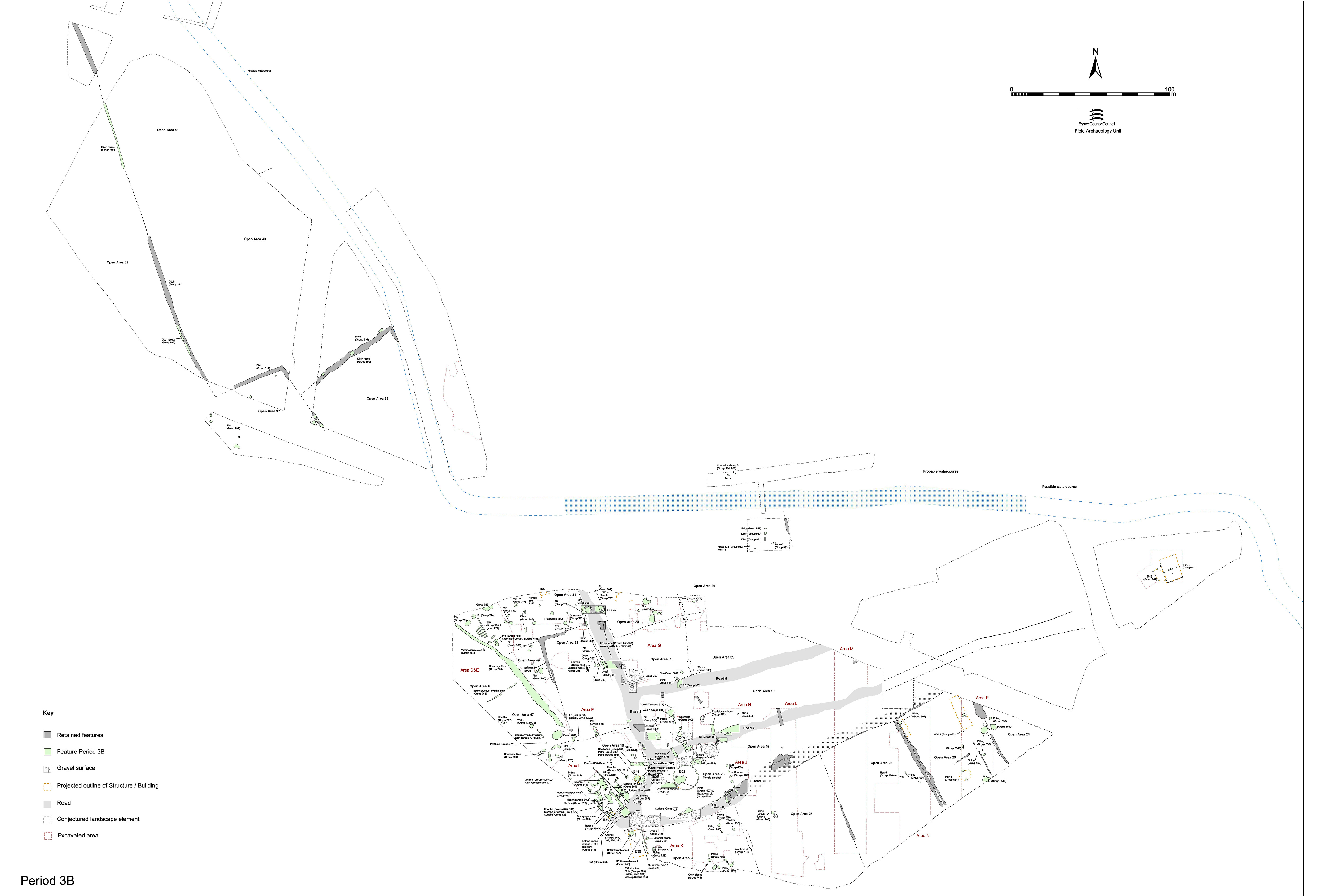
Ditch 25026 is almost certainly imposed early in Period 3, although much of its infilling dates to Period 3B. It is probably (at least partly) contemporaneous with 25018/25028. As it appears to have at least three phases of cutting/re-cutting, it seems reasonable to push its original construction back to Period 3A. Only segment 9318, however, yields pottery earlier than Period 3B date.
Substantial ditch 25026 runs parallel to 25028, some 10m to its west. Up to 3.0m wide and 0.58m deep, it appears to be a single cut along most of its length. Its northern terminal broadly coincides with the point at which parallel boundary ditch 25018 curves off to the west (as did its predecessor 25019). Within this northern terminal two minor re-cuts are recorded, suggesting some degree of maintenance of the boundary. It is possible that this terminal marks the position of a point of access into OA31 - particularly if it is conjectured that a northern continuation of the ditch would reasonably mirror the curving course of 25018. If indeed the case, ditch 25006 could perhaps be construed to represent this continuation. No southern end of 25026 is identified but the ditch is exposed for a distance of over 80m before becoming lost beneath unexcavated later pits and silt layers. It is likely that it extends as far as east-west ditch 25035 (see Group 770), perhaps merging with it or a forerunner of it.
Ditch 25026 displays a varying pattern of depositional activity along its length. At its northern end artefact assemblages are relatively small and limited in range, with only small quantities of pottery, tile and animal bone present. Artefact assemblages are larger and more varied from the southern parts of the ditch, which seem to have remained open longer and accumulated a more varied range of materials. This perhaps reflects decreasing occupation and depositional activity outwards from the Central settlement Zone.
It is postulated above that ditch 25006, located in the extreme north-west of Excavation Area D and extending beyond it, marks the northward continuation of the same boundary as 25026. Together with that of 25026, its terminal may therefore define the position of a 9m-wide entrance off the trackway, into OA31. Where excavated (seg. 9177) it is established to be shallower than 25026.
Poorly dated slots/gullies 9068, 25003 and 25013 are all located within this posited entrance between 25006 and 25026. These could be construed to be the remnants of a gate structure or a less substantial infill of the access gap. All pre-date features accorded a Period 3B or 3C date and so could be contemporary with the functioning of the boundary ditches.
A number of fragmentary patches of gravel surfacing, both large and small, are mainly confined between ditches 25026 and 25028 and may amount to surfacing of the Period 3A routeway. These layers are divided into two groups: 9603 (Group 762) and 9523, 9524, 9525, 9560, 9561, 9563, 9570, 9571, 9602, 9626, 9644, 9645, 9661, 9676, 9699, 9706, 9708, 9738, 9739, 9752, 9808, 9918 (Group 765) - the distinction being that 9603 has an ill-defined relationship with the earlier Group 150 (Period 2B) ditch.
They survive as very thin layers of pebbles, preserved best where pressed into the surface of the underlying brickearth. Occasionally they are found to be two or three layers thick. Cumulatively, they attest to a surface, or series of surfaces, which cover an area in excess of 60m north-south by 20m east-west [NB: the track is only c. 11m wide].
Those surfaces lying between the ditches (9523, 9524, 9525, 9626) are the best preserved and clearly seal Period 2B features (e.g. ditch 25030 Group 153). The relationship between surfaces and other ditches is often difficult to determine, because the surfaces rarely physically reach the ditch edges. This made it difficult to establish in the field whether the ditches cut the surfaces or the surfaces ran up to the ditch edges. It seems that the latter may be more likely and the extent of this gravelling is probably defined by the ditch lines, allowing them to be contemporary. The most northerly recorded extent of these deposits is recorded as 9644 and 9645. It is not established whether this surface continues to the south beyond its point of truncation by later ditch 25015 (Group 777 Period 3B).
Various gravelly silt layers lie on top of, or sandwiched between, these gravel surfaces, presumably representing degraded surfacing or use-accumulation and perhaps hint that there were several phases of surfaces, or at least repairs. Investigation into the presence of surfaces to the east of ditch 25026 is extremely limited, only being undertaken where segments are excavated through the ditch itself. Only one fragment of a possible surface, a gravel-rich clay-silt (9563) overlying brickearth, is identified in this location.
In overview, this apparently linear deposit of laid gravel was recognised early on during the fieldwork and was regarded as a possible road surface. However, it is likely that its linear aspect is misleading, as the parallel enclosure ditches bias the way in which the gravel surfaces are viewed. While an extension to the west seems unlikely (the few fragments of surface here all look earlier), it is by no means certain that they do not continue further to the east - very little excavation was undertaken beyond ditch 25026 (Group 766), which forms the eastern limit of Excavation Area D. Indeed, none of the supposed limits of this deposit are certain. While deposits such as 9626, 9644 and possibly 9601 suggest an edge just east of ditches 25016/25017 (Group 150 Period 2B), other evidence points to a further eastward continuation. Layer 9603 (Group 762) seems to be cut by this ditch and may in fact equate with gravel surfaces along its opposite side, such as 9636 and 9761 (Group 279 Period 2B). Also, there is no clear edge at the gap/entrance to the south of this same ditch, with further small patches continuing from 9601 on the east through to 9671 on the west side. It is probable that the gravel surfaces either side of this boundary are separate entities, with those to the west closely associated with occupation remains (Building 15) inside their own enclosure. Similarly, on the east side of the gravel surfacing 9525 suggests a real edge was present, but 9603 (Group 762) and 9918 are cut by ditch 25021 (Group 776 Period 3B).
It is notable that the surfacing between ditches 25026 and 25028 is not encroached upon by discrete features such as gullies and pits until the mid-2nd century AD.
Internet Archaeology is an open access journal based in the Department of Archaeology, University of York. Except where otherwise noted, content from this work may be used under the terms of the Creative Commons Attribution 3.0 (CC BY) Unported licence, which permits unrestricted use, distribution, and reproduction in any medium, provided that attribution to the author(s), the title of the work, the Internet Archaeology journal and the relevant URL/DOI are given.
Terms and Conditions | Legal Statements | Privacy Policy | Cookies Policy | Citing Internet Archaeology
Internet Archaeology content is preserved for the long term with the Archaeology Data Service. Help sustain and support open access publication by donating to our Open Access Archaeology Fund.