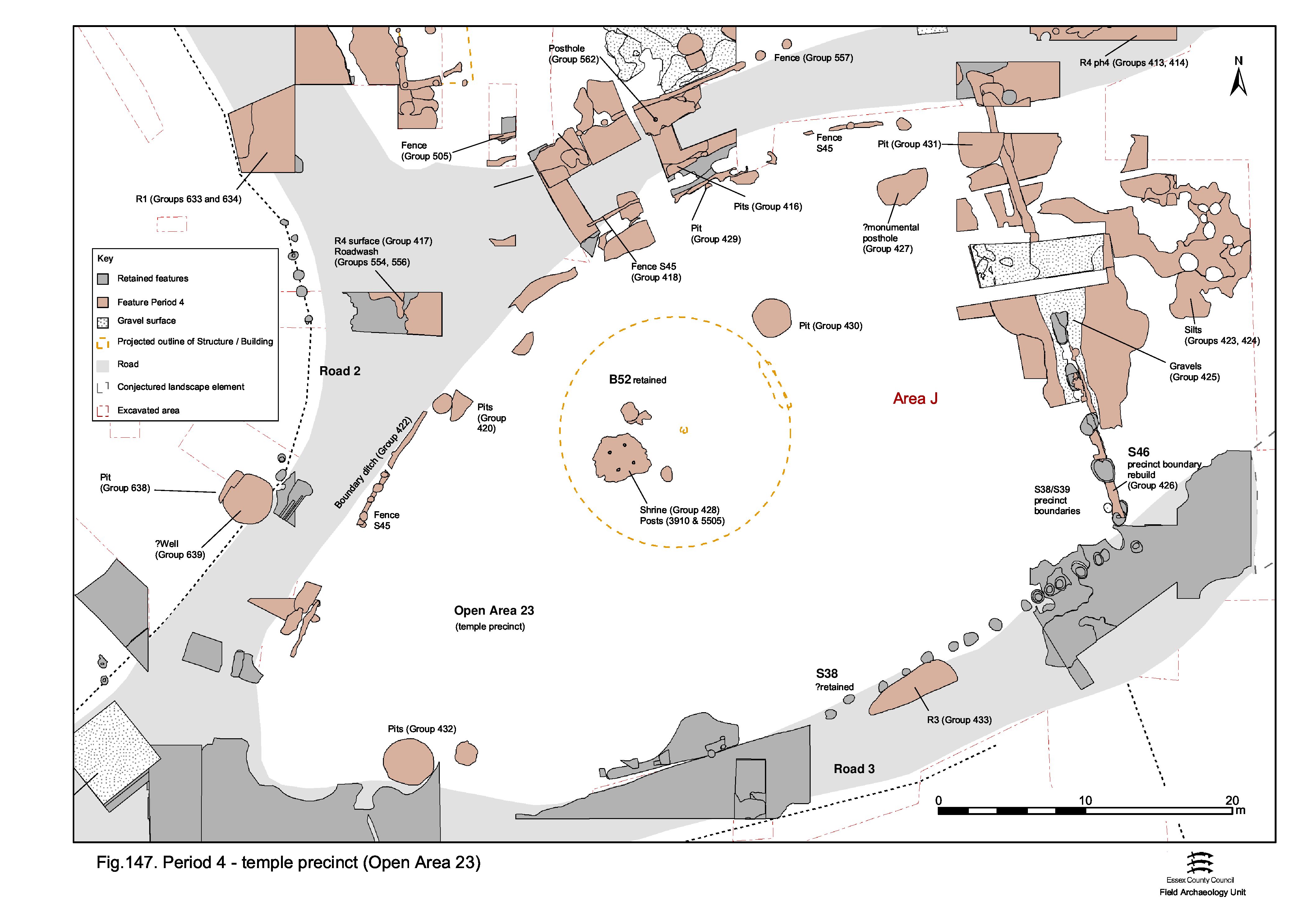
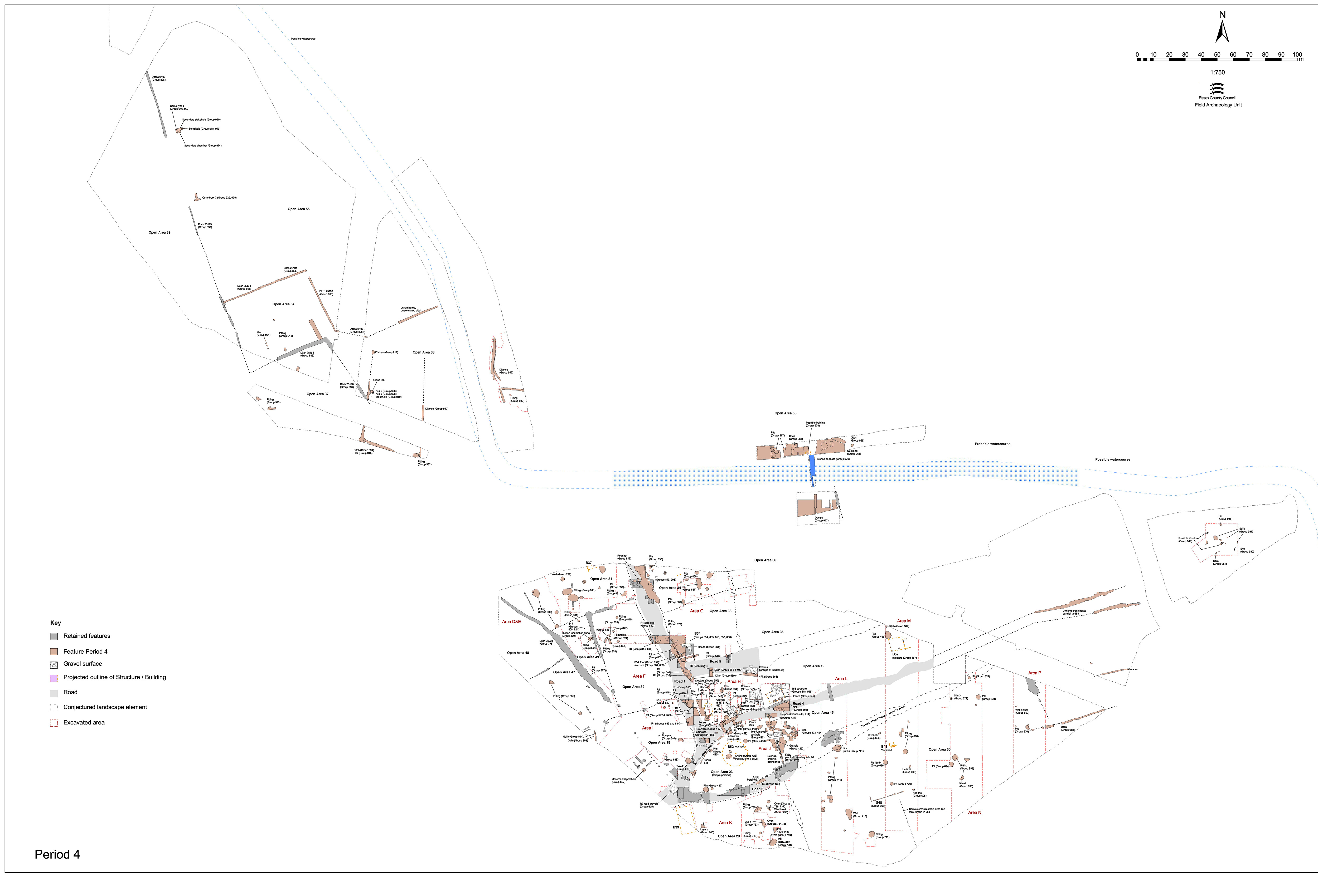
What appears to amount to relatively minor change and modification to the interior of OA23 continues throughout Period 4 (Figure 147). Boundaries are replaced, both along the roadsides and the eastern precinct frontage, so reinforcing and perhaps increasing the separateness of the religious focus. Its gravel surfacing is renewed or repaired and an apparent monumental post erected in the north-eastern corner.
Ditch 25070 (segs 5267, 5437, 5525, 5695, 13362, 21061) is an irregular, linear feature that follows the curve of Road 4 and its junction with Road 1. It replaces the earlier Period 4 Structure 45 boundary fence (Group 418) along the northern side of the temple precinct. Although the ditch width varies significantly, all the excavated segments are c. 0.5m deep. Both terminals are located (segs 5267 and 5928), so establishing a total length of c. 28m. It is postulated that ditch fragments 5525 and 6595 are further, intermittent, elements of the same general roadside boundary; whether these define a 12-16m-wide gap is uncertain.
Like the pits that occur alongside, the ditch contains tesserae, tile and occasionally oyster shell and septaria rubble. The majority of the tesserae come from segment 5437. Similarly, this ditch also contains a scatter of artefacts that may be deemed to have religious or votive connotations; excavated segment 5437 includes a copper-alloy letter 'T' (SF2091), coin and chicken bones, while terminal segment 5928 contains a key (SF3556).
At the eastern side of the precinct but mostly extending beyond the precinct boundary into Open Area 45, lie thin gravel layers 18740, 21816, 21901 and possibly 21651 (all Group 425). These represent the latest surviving gravel 'occupation' surface encountered in Excavation Area J. The surfaces themselves overlie silt deposits that can be broadly grouped into two types; a lower gravelly sandy-silt (Group 423) that is probably in part derived from degradation of the Period 3 surface below and an upper dark silt (Group 424). As the rubble footings of the precinct wall rebuild Structure 46 are demonstrated to cut through some of the Group 425 surface fragments, this sequence represents accumulations and resurfacings of the area in front of the temple precinct before the new precinct wall (Structure 46, below) is built.
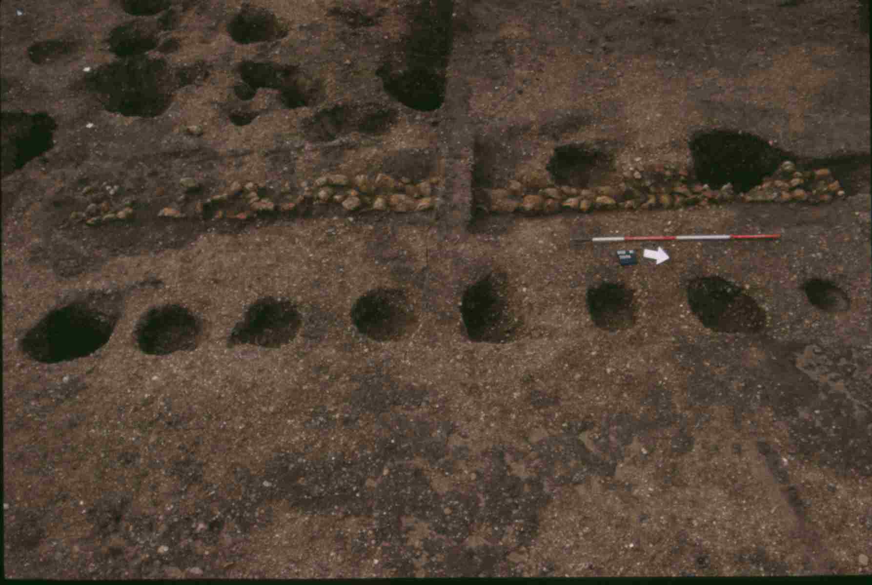
Following the removal of the posts of the earlier, wholly wooden, precinct wall Structure 39 (Group 403, Period 3B) a replacement, Structure 46 (segs 18739, 18798, 21810, 21876, 21934, 21964, 21981, 22009) is constructed in the same position. This survives as a linear arrangement of flint and septaria stone rubble, with occasional tile fragments (Figure 137). This rubble is bonded in places with clay, and is generally accommodated within a shallow construction cut - although this is often absent where there is a decent underlying gravelled surface. This wall footing spans the 31m between Roads 3 and 4, broken only by an off-centre 3.1m-wide entrance which is aligned upon that of the temple cella (15.2m from the south end of the wall, but only 12.9m from the north). Probably only the footing of this wall is constructed of stone rubble, although a dwarf wall is also possible - which may account for the lack of surviving associated post-settings. Judging by the shallow depth of its foundation, and the relative lack of loose stone in the vicinity, the majority of the wall is most likely to be of wooden construction. Whether this replacement is simply necessitated by deterioration of the earlier wall, or is part of a scheme of enhancement and aggrandisation of the eastern façade, is unknown.
Dating of the construction of Structure 46 is not particularly clear. Given that repairs are probably carried out in the later 3rd century (see Structure 53, Group 439 Period 5), the wall could be built any time between the mid/late 2nd and mid-3rd century. The two coins (SF7687, SF7689) collected from on top of truncated wall remains 21810 suggest a final demolition date in the mid- to late 4th century (see Groups 446, 447 Period 6).
22114 is a large and relatively deep sub-rectangular pit that is seemingly dug at the foot of the new precinct wall. Subsequently, perhaps inevitably, this pit creates subsidence problems for the wall that necessitate the underpinning (Structure 53) in Period 5 that has been noted above. Mostly containing tile and animal bone, it is noteworthy that this pit does not appear to attract votive deposition. Tile tesserae are again present.
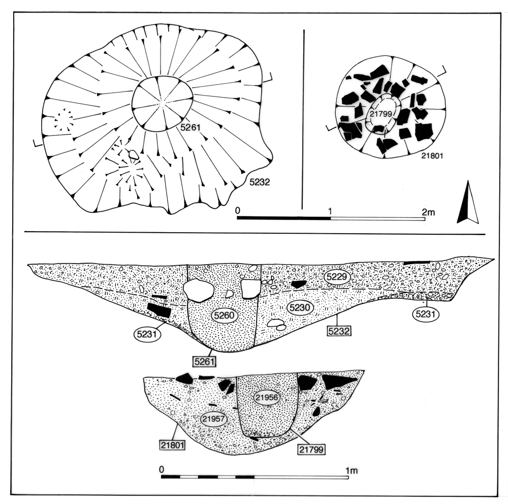
A pit 5232, located in the north-east corner of the temple precinct, is a 3.4m by 1.5m cut that survives to a depth of 0.5m. It contains a large post-pipe, up to 0.4m diameter, that is packed around with flints and the rest of the pit filled with clay (Figure 149). Apparently erected in the 3rd century, the post appears to stand perhaps until the late 4th century. There are no features in obvious association with this post and it seems likely that it stands in relative isolation - perhaps as a marker or 'totem pole' of some kind. It does not occupy a prominent or central place, as was the case with monumental post-hole F1977 at Witham Ivy Chimneys (Turner 1999, 40). However, if it is a monumental post, no structured deposition is made either in its pit or in the immediate vicinity.
The few pits along the southern margins of the precinct seem to have a similar character to those on the northern edge. Pit 5394 (Group 432) is one of the most substantial at over 3m diameter and in excess of 1m deep; reaching below the water-table. It is located at the west end of the precinct and contains a large deposit of clay. Although not fully excavated, it is possible that this is in fact the upper portion of an earlier well. Clay deposits 5447 and 5457 could therefore represent its slumped lining or a capping deposit. Above the clay, its mid-Roman rubbishy fills included a 20kg oyster shell dump derived from its final use for rubbish disposal.
Though smaller, adjacent pit 13084 contains a similar finds assemblage, including oyster shell, which may indicate an association between the two. Both also contain chicken bones, and 5394 a coin (SF6917), bone hairpin (SF6843) and iron needle fragment (no SF number) that would seem to confirm structured deposition or else disposal of votive debris in selected features along the southern side of the precinct.
Small pit 5245 (Group 429) is similarly located along the northern edge of the precinct, but cuts Period 4 boundary ditch 25070. As such, it might also be regarded as a Period 5 feature. It contains only a small quantity of pottery and tile, but also includes some tesserae and copper-alloy ring SF1292.
Internet Archaeology is an open access journal based in the Department of Archaeology, University of York. Except where otherwise noted, content from this work may be used under the terms of the Creative Commons Attribution 3.0 (CC BY) Unported licence, which permits unrestricted use, distribution, and reproduction in any medium, provided that attribution to the author(s), the title of the work, the Internet Archaeology journal and the relevant URL/DOI are given.
Terms and Conditions | Legal Statements | Privacy Policy | Cookies Policy | Citing Internet Archaeology
Internet Archaeology content is preserved for the long term with the Archaeology Data Service. Help sustain and support open access publication by donating to our Open Access Archaeology Fund.