Archive: An archaeological database of higher-order settlements on the Italian peninsula (350 BCE to 300 CE)
The study is concerned with 'urban' and 'proto-urban' centres. The adjective, 'urban', is problematic, however, owing to difficulties with definition (cf. Marcus and Sabloff 2008). Like the nouns 'city' and 'town', archaeologists use the adjective 'urban' to describe a broad spectrum of large nucleated settlements. Cities of various kinds have been a feature of the Old and New Worlds for millennia. With the growing appreciation among archaeologists of just how diverse such sites could be, in terms of their formation processes, size, structure and function, it has become increasingly difficult to find a meaningful universal term. 'Proto-urban' is often used in the context of Italian archaeology to refer to a fortified settlement with little archaeological indication of dense or highly structured habitation within its walls. Because many of these centres nevertheless demonstrate marked development over time, the term 'proto-urban' has come under fire for not sufficiently recognising settlement evolution (Gualtieri 2004, 40, n.45).
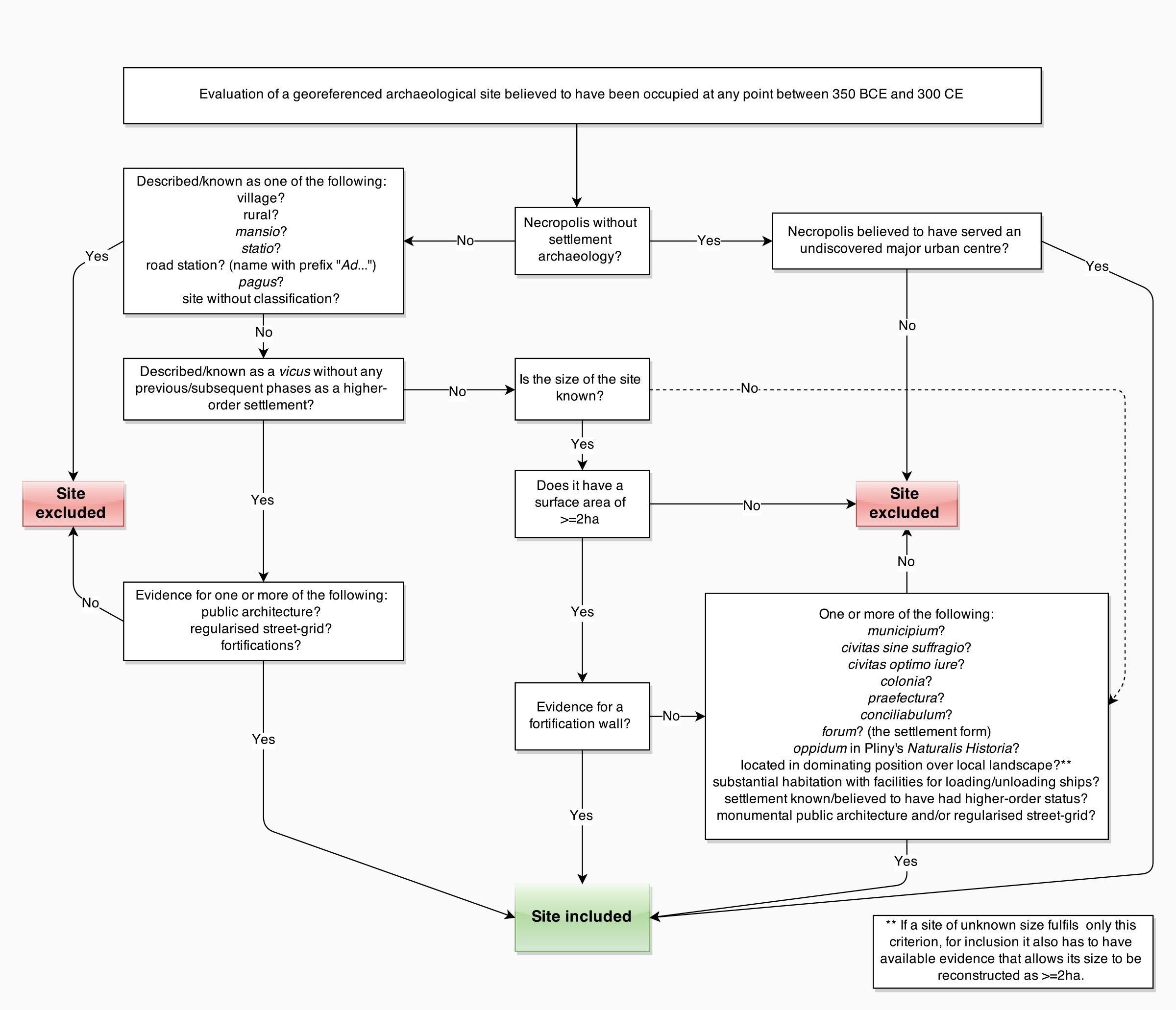
To avoid misunderstanding, a term was devised specifically for the project: 'higher-order settlement'. This is defined as a settlement belonging to a community that exercised or might have exercised control over a territorial unit. This definition has the benefit of being equally applicable to urban and proto-urban settlements, but it also presents a challenge: how can one determine whether or not a settlement once controlled a territory? For the Roman period, texts and inscriptions document the legal status of hundreds of individual sites; these statuses indicate that some of these settlements controlled territories (e.g. coloniae and municipia) and others not (e.g. vici and pagi). Hence all archaeologically known colonies founded by Rome are included in the database, regardless of size, because these settlements had legal control over their territories. For the same reason all the municipia (self-governing communities of Roman citizens) which have been located with confidence are included.
Conversely, sites that Roman texts indicate to have been subordinate population centres, regardless of size, have been excluded. These include road-stations (mansiones, stationes, and settlement names with the prefix 'Ad...') and other minor settlements (vici, pagi). The only exceptions to this are related to secondary research questions. All vici (village-like settlements) found to possess urban characteristics (e.g. fortifications, regularised streets, civic architecture) have been included with the aim of establishing whether there was a Cispadane (south of the Po river) precedent for the phenomenon of the urbanised vicus, or 'the small town', known in northern Italy, Gaul, Germany and Britain. Some municipia and coloniae developed from vici and others became vici after periods of urban decline, and this is also recorded in the database. All the archaeologically known fora (i.e. the settlement type, not to be confused with the monumental public space found in most Roman towns) were included with the aim of establishing whether there are any commonalities in their urban forms, even though some were dispersed settlements of indeterminate size.
If ancient textual documentation supports the confident categorisation of particular Roman settlements as higher-order settlements, the absence of this information for earlier periods means that it is impossible to tell how many of the pre-Roman sites administered their own territories. Occasionally, the results of landscape archaeology can provide a good indication if, for example, patterns of rural habitation are found to have gravitated around large nucleated centres. It was thus necessary to determine an archaeological definition of a higher-order settlement for sites that are not described in surviving ancient texts. Size has been chosen as the main attribute upon which to base this judgement, primarily because it allows consistency. All fortified centres with a perimeter enclosing an area of 2ha or more are included in the study, although the very high number of such settlements means it is possible that a few sites have been missed. This particular surface area size has been selected for two reasons. Firstly, it permits the inclusion of all colonies founded by Rome. Most of the urban centres of Rome's peninsular colonies were fortified, and several were under 3ha. Since they possessed territories, they qualify as higher-order settlements. Circeii was an early Latin colony and its walled area actually enclosed 1.5ha (Quilici and Quilici Gigli 2005, 123–46), making it the smallest site and the only exception to the 2ha threshold in the database. The fact that fortified Roman centres of c. 2ha could administer territories naturally has no bearing on whether the same applies to fortified non-Roman settlements of this size. The city-states of Latium, Etruria and Magna Graecia were higher-order settlements by definition, but there are hundreds of settlements for which a similar status is difficult to prove. Since much more is known about Roman settlement hierarchies than those of ancient Italy's other peoples, it is important to resist the temptation to imagine that Roman-style systems existed elsewhere on the peninsula prior to conquest (Stek 2009, 107–20). In some cases, it might be overly simplistic to envisage that settlements either did or did not have control of territories. It has been suggested, for example, that some very small fortified hilltop settlements in Etruria controlled territorial units (Becker 2002, 90–92), yet it is possible that they themselves were subordinate to much larger Etruscan cities. Unfortunately, archaeology provides virtually no direct insight into the potential complexity of pre-Roman settlement hierarchies. Because it is not possible to establish with certainty whether many sites had higher-order status, the 2ha threshold was applied to non-Roman as well as Roman fortified sites for consistency, and with the belief that many higher-order settlements are likely to be among them.
The second reason for the 2ha threshold was to restrict the number of sites in the database. With the exception of Circeii, all other fortified sites <2ha were excluded because hundreds of them have been identified (see below), and their inclusion was not feasible within the limits of the project.
Settlement sites with monumental fortifications are particularly visible archaeologically, and thus have drawn the attention of field archaeologists. Of the 583 sites in the database, 451 had or are suspected to have had fortifications. To a degree, this preponderance of fortified sites reflects the reality that they are easy to identify and represent well-defined units for archaeological investigation. As well as to protect those within them, stone fortifications would have impressed both inhabitants and visitors, and extant examples still elicit this response (Sewell forthcoming). In published works, scholars often use the date of its fortifications to ascribe urban or proto-urban status to a settlement. While it is reasonable to assume that stone defences were a characteristic of important centres, some subordinate settlements were also fortified. For example, 14 published sites in southern Italy are described as Greek forts or towers, dated variously from the Archaic to the Hellenistic period. None of them were greater than 0.25ha in size. Fortification walls and higher-order status were thus not synonymous.
This is also confirmed by the existence of large settlements with no fortifications during and following the Roman conquest, many of which were likely to have been higher-order settlements. For example, in the 4th century there are numerous references in Livy and other Roman authors to the names of settlements for which the earliest archaeological evidence dates to a period sometime after the date they are first mentioned in the texts, including sites such as Privernum, Plestia, Fundi and Ricina. How do we explain this? Although the reports might be erroneous, another possibility is that the early settlement forms assumed by these ancient communities are hard to recognise archaeologically: specifically, they possessed no city wall. Some examples of this situation are known, such as the site assigned the modern toponym of Cupola, a sprawling dispersed Daunian settlement in the south-east of the peninsula, the physical limits of which are unclear because it has no known fortifications (Rocco 2004). The settlement appears to have been the site of pre-Roman Sipontum. Meanwhile, nearby Roman Sipontum has produced no settlement archaeology pre-dating 194 BCE, its reported date of foundation as a Roman colony (Livy 34.45). This also seems to be the moment when adjacent Cupola was abandoned (Greco and Longo 2008, 455–58; Lackner 2008 , 185–86). Cupola's settlement archaeology dates back to the start of the first millennium BCE, and it is postulated to have been the original Sipontum because Livy reports that in 335 BCE a city of this name in this general location was captured by Alexander the Molossian, the uncle of Alexander the Great (Livy 8.24). It was likely to have been a higher-order settlement because its capture was of sufficient significance to be recorded historically, and because the settlement that replaced it was a higher-order settlement. Although Cupula probably held sway over a territory, it is otherwise without characteristics that we associate with urbanism. Urban form and higher-order status were thus not synonymous.
The Samnites had similar settlements; Abellinum, Allifae, Caudium, Telesia, Aequum Tuticum and potentially Aeclanum were all relatively low-lying dispersed settlements of the pre-conquest period which went on to develop urban characteristics and several became Roman towns (De Benedittis 2013). There are still, however, major lacunae across the rest of the peninsula. For example, most peninsular municipia developed from pre-Roman communities (Ciancio 2002). The study has documented 12 municipia that developed into urban centres in the 1st century BCE in locations where archaeologists have found no trace of earlier settlement from which they might have been derived. Thus it is possible that at least some of these 12 municipia might have earlier dispersed forms of settlement yet to be discovered. There might have been many polycentric or dispersed higher-order settlements, some surviving long into the Roman period. Those which at some point constructed a city wall and developed into Roman towns are included in the project because their physical remains and stone inscriptions are more easily found. There is an indeterminable – possibly large – number of sites that did not go on to become municipia which remain to be discovered archaeologically, or which might be among the thousands of scatters of ceramic and tile listed in the published carte archeologiche, many of which are 2ha or above in size. The potential presence of higher-order settlements among these scatters poses a challenge for the 2ha threshold adopted for this project. This is because the vast majority of these scatters were likely to have been farms or other forms of rural settlements. Size alone is therefore not an indicator of a higher-order settlement. It was thus important to incorporate all of the non-fortified sites that may have been higher-order settlements while excluding those unlikely candidates. Firstly, any site described as 'rural' or a 'village' in published works was deemed to be subordinate and was thus excluded, regardless of size, as were all unclassified sites discovered through surface survey (e.g. 'surface scatter'). Six criteria were devised for other types of settlement sites of 2ha and above around which no fortifications have yet been found; for each site, one or more of these criteria needed to be satisfied for it to be included in the study:
Based on these criteria, 132 unfortified sites of 2ha or more were included, 73 of which either became or were founded as Roman towns.
Ninety-one sites are included for which no estimate of surface area can be calculated, which includes both fortified and unfortified examples. Inclusion was determined by the same criteria listed above for unfortified sites. If, as a result, a site of unknown size only fulfilled Criterion 2 (dominating position), it was only included in the study if there were strong indications that it was 2ha or above in size. This was determined through an assessment of size extrapolated from published plans and text. In relation to published images, there are numerous plans of hilltop fortifications that have only partially survived, displaying the extant sections of perimeter wall, for example on just one or two sides of a hilltop (e.g. Caiazza 1986, Tav. 20). In such cases, the continued lines of the missing wall-sections were hypothetically reconstructed based on the trajectories of the surviving sections, the absolute height of the terrain on which they are located and the prolongation of topographical features that seem to have dictated their course. Naturally, such hypothetical reconstructions are highly interpretative. They are undertaken purely to determine whether or not a site was likely to have been 2ha or over and should therefore be included in the study. If the assessment was positive in this respect, the hypothetically reconstructed size was neither recorded nor input in the database because of the lack of interpretational certainty. For some sites, it was possible to determine whether a size of over 2ha was likely on the basis of an author's description of the site. As an example, the habitation of the Lucanian hilltop site, Montrone (Oppido Lucano), is simply described as being spread over an axis of 1km (De Gennaro 2005, 68). Because this 1km-axis need only be 20m wide for it to cover 2ha, the site is included though without any estimate of its size in the database. If there was insufficient published evidence to be able to evaluate whether a hilltop site was 2ha or above (and which also did not fulfil Criteria 1, 3-6), it was excluded from the study.
Literature was consulted in relation to 85 necropolises for which the sites of their associated settlements have not yet been determined. Only five of them are included in the database (Cafaggio, Casone, Corcolle, San Brancato and Santo Mola), based solely on specific statements by authors that they were likely to have served major settlements. The chronologies of these necropolises are assumed to reflect the chronologies of the unknown associated settlement sites. Since burial practices changed at various times and in different areas of the peninsula, the chronologies of these necropolises may not represent the full chronological range of their associated habitations.
Many of the settlement sites in the study have produced artefactual evidence, above all ceramic, that pre-dates their city-walls and other elements of the built environment – physical elements that contribute to the archaeological impression that they were higher-order settlements. This material only indicates that a site was occupied from a particular period onwards, but it does not provide any clear testimony regarding any potential higher-order status. Thus it is not always possible to establish whether a site was founded as a higher-order settlement or whether it attained this status over time. Where the evidence allows, the earliest and latest dates of occupation at each site is recorded in the database, but it should not be automatically assumed that settlements had primacy within their territories throughout their full history of occupation. All of the decisional processes described in this section are visualised in Figure 2.