Archive: An archaeological database of higher-order settlements on the Italian peninsula (350 BCE to 300 CE)
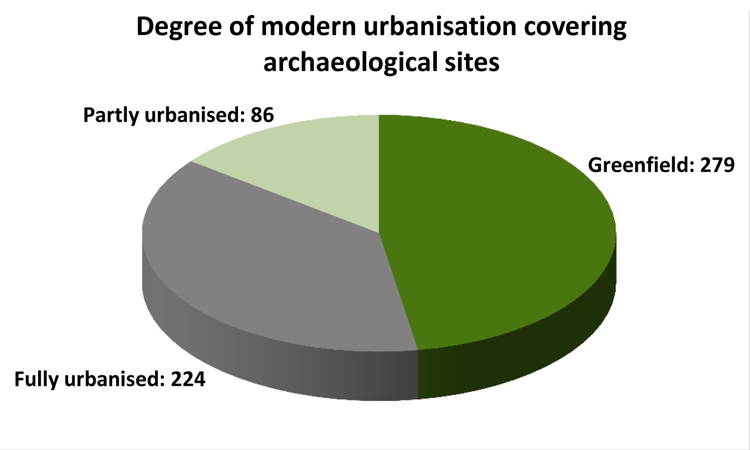
The archaeological literature reveals notable regional diversity in the numbers and forms of settlement sites, the types of evidence, their states of preservation and the degrees to which they have been studied. Most of the sites within the study area that fulfil the criteria for inclusion have suffered spoliation for reusable building materials during and after classical antiquity. Just over half of the sites are covered today with substantial areas of modern habitation (see Figure 3). In many cases, continual occupation and urban renewal over centuries have led to the disappearance of ancient structures, thus posing significant challenges for archaeological investigation. Of the greenfield sites, those on hilltops have been subject to processes of erosion over at least two millennia, and many low-lying sites have been disturbed by deep ploughing from the mid-20th century onwards. In terms of distribution, the numbers of greenfield sites are proportionally greater in the more mountainous areas of the peninsula. This indicates that hilltop sites are much more likely to be free of modern structures than low-lying ones. Thus the type and degree of preservation varies enormously as does the level of access for investigation.
For data collection purposes, only published sources have been consulted without recourse to unpublished archival material. After establishing the names of relevant sites from published regional surveys, the most efficient strategy has been to then consult the most recent publications on each site. As well as containing the latest evidence, they often present and assess the more important of the previously published discussions. Older publications have been consulted if and when it was clear that they were still important, but it is likely that many older and superseded interpretations have not been documented. For the description of each settlement, archaeological evidence derived from stratigraphic excavation is prioritised, but not all of the sites have been excavated. For those that have not, sometimes the results of surface survey can be drawn upon. The existence and extent of some features, such as the course of fortifications and other standing remains, are often derived from topographical surveys. Occasionally, the presence of public buildings is conjectured from antiquarian reports or place-name evidence. Ancient texts, such as inscriptions and literary topographical descriptions, supplement data derived from modern studies and also provide information on the potential existence of monumental public architecture that is no longer extant.
Italy's strong tradition of regionalism has clearly shaped the nature and comparability of the evidence. In terms of archaeological research, there are disparities in the degree to which different regions have been studied. The Samnites have the highest number of attributed settlements, the majority of which are hilltop fortifications. Only ten of these 51 sites (≥2ha) have been subject to any systematic study, demonstrating our reliance on a few key examples to understand a very large group of sites. Relatively good data are available for Etruscan settlements owing to the long tradition of Etruscan studies, and the same can be said for the Lucanian centres, many of which have been well published. Aequian, Marsic and Vestinian fortified centres are numerous and many have been recognised over the last 30 years, but aside from some observations made about surface material and some structural remains, very little can be said with certainty about their chronologies. Many of the centres in Umbria that became Roman towns have been well studied, but there are numerous pre-conquest Umbrian sites smaller than 2ha, again about which very little is known. In Liguria, many of the pre-Roman sites have been published, but the majority are very small and are thus omitted from the database. Very few sites fulfilling the criteria for inclusion are found in the northern areas of the peninsula where Gallic tribes, the Senones and the Boii, established themselves from the early 4th century BCE onwards. No Picentine sites fitting the criteria for inclusion are known apart from those that went on to develop into Roman towns. The picture that emerges is one of diversity not only in regional settlement forms and numbers, but also in the degree to which the regions have been studied.
At the time of the Roman conquest, and for a considerable time after it, regional differences are reflected in distinct settlement forms associated with broadly defined geographical areas. Many of the areas that ancient writers ascribe to Italy's various pre-Roman peoples are associated with distinct material cultures, ancient languages and settlement forms. Yet the geographical correlation between historically attested peoples and their archaeological assemblages is not always easily discernible (Bradley 2000, 112-113; Stek 2013, 405). On occasion, it has proved impossible for archaeologists to confirm which particular cultural group dominated a site in its pre-Roman phases, such as at San Salvatore (Timmari) (Osanna et al. 2012), Frigento (Ebanista 2009), and Montescaglioso (Canosa 1993).
Many scholars have outlined hypothetical territorial boundaries, but there is little consensus, largely because they are necessarily based upon lacunose Roman sources (e.g. De Benedittis and Ricci 2007, fig. 2; Caiazza 2006 ; Coarelli and La Regina 1993, 5-17). Even if such an exercise were possible, the boundaries should not be thought of as static features of the landscape (Bradley 2000, 112-113; Suano and Scopacasa 2013, 405). Ancient textual sources and archaeology testify to repeated shifts of territorial control as a result of conflict between various cultural groups. It is therefore inadvisable to define the regions associated with distinct peoples with precise territorial boundaries and, consequently, calculations of settlement densities within them cannot be meaningfully undertaken.
This issue also means that it is difficult to assign sites to the appropriate regional cultural group with any confidence. Each site is tagged with the cultural label that is most often proposed in the archaeological literature, although it is important to note that in most cases this is ultimately derived from Roman texts. If publications expressed uncertainty or conflicting opinions on the identity of the relevant cultural group, this is noted in the database. If no identity is provided by authors, in some cases it is assigned based on published maps showing ancient territorial boundaries (e.g. De Benedittis and Ricci 2007, 8, fig. 2), but only if the site is well within the hypothetical boundaries. These assignments are thus speculative: little is known about how pre-Roman peoples regarded themselves, and many sites may have accommodated populations of varied origins. A pragmatic approach has been taken towards accommodating ancient Italy's regional character in order to permit historically sensitive analysis. Specifically, it permits the grouping and comparison of sites on the basis of commonly used cultural categories, allowing broader patterns of similarity and difference to be identified and assessed.
Under Augustus, Italy was divided into 11 regions for some kind of administrative purpose, though the precise motive is not directly attested in the ancient sources (Nicolet 1991; Laffi 2007, 81-118; Bispham 2007b, 63-66). The boundaries of these regions can be reconstructed with relative confidence and are widely recognised and used by scholars. Each site in the database is assigned to the relevant Augustan region, but this grouping is only historically relevant for the second half of the period under study. All settlements founded after the Romans achieved predominance in the area in which they are located, are labelled as 'Roman' in the database. This is not meant to be an indication that they were ethnically composed of Romans or possessed Roman citizenship (although some were and are identified as such by other means). Rather it is a chronological label so that they can be differentiated from the pre-conquest sites during analysis. All of these post-conquest sites have the identity of the pre-Roman people associated with the local area recorded as a separate data category.
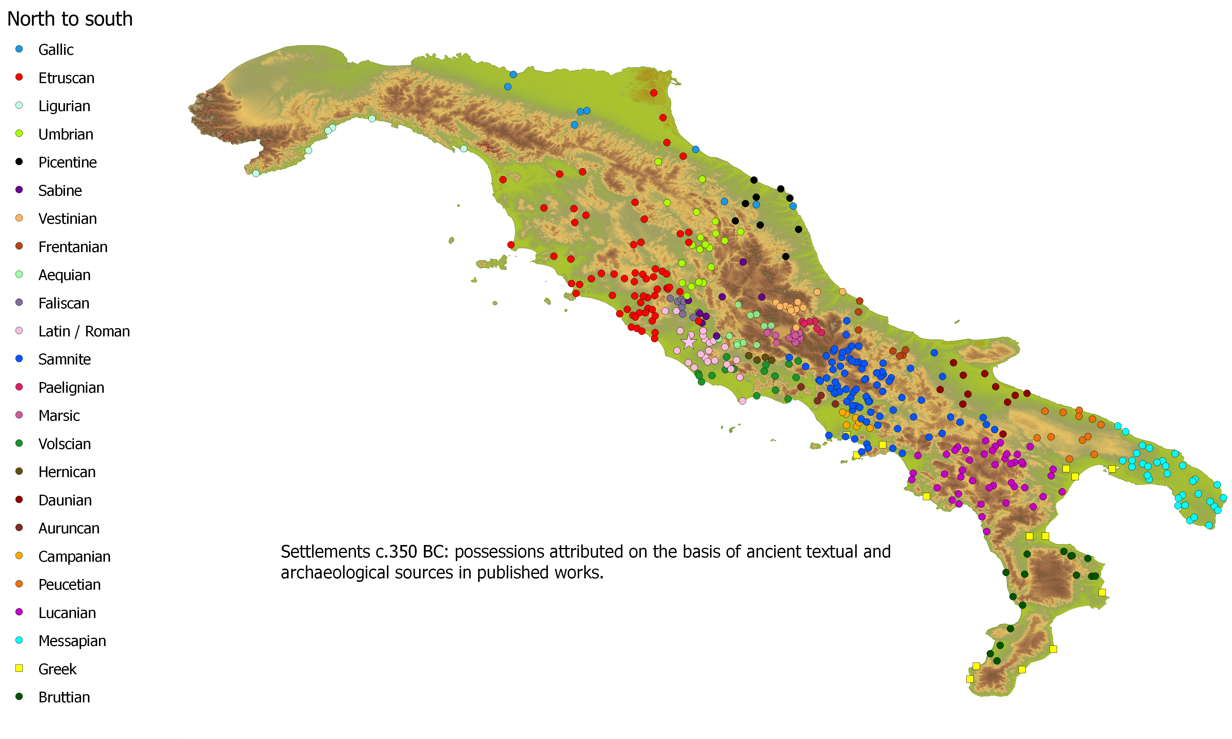
There are significant variations in the quantities of sites attributed to each of Italy's pre-Roman peoples (Figure 4). This disparity becomes even more pronounced when the sites that are excluded from the study due to their small or indeterminate size are considered. Although 583 sites fulfil the study's criteria for inclusion, these are only a minority of the 1518 sites that were assessed. A running list of those sites failing to meet the criteria for inclusion ensured individual settlements were investigated only once. Because the list includes a brief description and a bibliographical reference for each of the 935 excluded sites, this has developed into a resource in its own right and is also deposited with the Archaeology Data Service. The list includes 486 fortified sites smaller than 2ha, or of indeterminate size, which either did exist or could have existed at some point during the period 350 BCE to 300 CE. It should be noted that many of them have been linked to specific pre-Roman cultures in publications without knowledge of the sites' periods of occupation. Thus for many of these sites there is no actual proof that they were occupied during or after the conquest period.
With the inclusion of these additional sites, a clearer picture emerges of overall site numbers. The assigned identities in Table 1 reflect the immediate pre-Roman situation in 350 BCE. Many of these reflect the identities of cultural groups who had conquered or assumed control over others' settlements shortly before the Roman conquest. For example, the consequences of Samnite expansion from the second half of the 5th century BCE onwards for Table 1 are that the Samnites are assigned 13 settlements that they did not themselves found (including Pompeii).
| Pre-Roman people | Overall no. of settlements ≥2ha | Overall no. of fortifications <2ha or of unknown size | Totals | % |
|---|---|---|---|---|
| Aequian | 11 | 41 | 52 | 5.6% |
| Auruncan | 4 | 3 | 7 | 0.75% |
| Ausonian | 1 | 0 | 1 | 0.11% |
| Bruttian | 16 | 2 | 18 | 1.92% |
| Campanian | 7 | 0 | 7 | 0.75% |
| Daunian | 10 | 0 | 10 | 1.07% |
| Etruscan | 62 | 56 | 118 | 12.61% |
| Faliscan | 8 | 2 | 10 | 1.07% |
| Frentani | 5 | 1 | 6 | 0.64% |
| Gallic | 9 | 0 | 9 | 0.96% |
| Greek | 14 | 15 | 29 | 3.10% |
| Hernican | 4 | 0 | 4 | 0.43% |
| Iapygian | 1 | 0 | 1 | 0.11% |
| Latin | 22 | 1 | 23 | 2.46% |
| Ligurian | 6 | 36 | 42 | 4.49% |
| Lucanian | 44 | 32 | 76 | 8.12% |
| Marrucinian | 2 | 0 | 2 | 0.21% |
| Marsic | 19 | 46 | 65 | 6.94% |
| Messapian | 32 | 3 | 35 | 3.74% |
| Paelignian | 6 | 12 | 18 | 1.92% |
| Peucetian | 12 | 3 | 15 | 1.60% |
| Picentine | 9 | 2 | 11 | 1.18% |
| Praetutian | 2 | 0 | 2 | 0.21% |
| Sabine | 9 | 2 | 11 | 1.18% |
| Samnite | 84 | 96 | 180 | 19.23% |
| Sidicinian | 1 | 0 | 1 | 0.11% |
| Umbrian | 20 | 47 | 67 | 7.16% |
| Unknown | 5 | 34 | 39 | 4.17% |
| Vestinian | 11 | 39 | 50 | 5.34% |
| Volscian | 16 | 11 | 27 | 2.88% |
| Totals | 452 | 484 | 946 | 100.00% |
In summary, the archaeological evidence for higher-order settlements varies in quality and abundance. The database is 'archaeological' in the sense that each primary record represents a physical site, documented by a series of data fields derived from multiple sources: archaeological (excavation, field survey, topographical survey); textual (ancient literary sources, epigraphy, place-name evidence) and spatial (geographical coordinates). There are major regional differences in settlement forms and site numbers. Moreover, no two sites, or regions, were found to have been studied with the same intensity using identical investigative methods. The problem of uneven data quality has thus to be addressed, as is the case for any study that aims to understand historical processes affecting settlement patterns at any scale greater than the micro-regional. How can heterogeneous data be compared so that the results of the analysis can used with greater confidence?
One solution is to tag the various data with an indicator of the degree of confidence which can be placed upon them. This was a fundamental element of the database's research design (see further below). This approach permits analyses to be undertaken on multiple levels according to the robustness of the data and the results are to be handled appropriately. All the patterns identified must be critically evaluated. This is necessary, not only because of the variable quality and quantity of data, but also because the database can only describe, not explain, patterns. Correlations, for example, must be carefully studied before they can be interpreted as causation. In sum, the database is intended to facilitate empirical documentation of settlement forms and trends that have hitherto lacked a robust basis for discussion; critical evaluation of the patterns is then required to understand their significance and how best to interpret them.