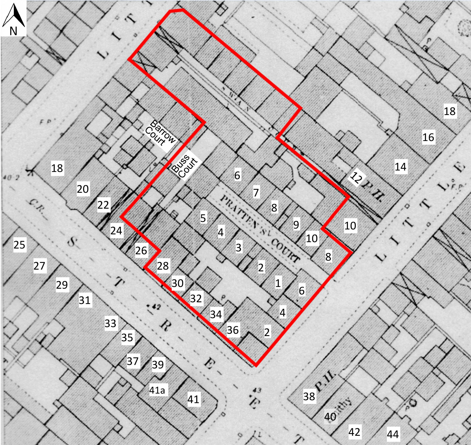
The first and perhaps most important point to make about all the work at Wade Street, both the excavation and the subsequent watching brief, is that it was not, ultimately, possible to recover a complete ground plan for any of the structures that were revealed, be they houses or buildings with other functions. The closest that the project came to establishing a complete ground plan of any structure was in fact, and with some irony, during the watching brief, when three complete walls of a cellar (103) fronting onto Little Anne Street were identified, and the internal face of the fourth wall, also intact, could be seen, running under the north-western side of Little Anne Street, but not accessed. Conversely, however, the excavation demonstrated in striking fashion that the surviving historic map evidence does scant justice to the sheer complexity of the developmental sequence of building on the site, although perhaps the nature of the site itself might have suggested that this was entirely to be expected. The maps, of course, represent only static snapshots of development, and may well not be entirely reliable, even those of the Ordnance Survey; as we have already noted, it has been shown elsewhere that surveying accuracy declines as the OS surveyors moved away from the easily accessible street frontages (see Footnote 14). And while some of the structures, mainly walls, that were revealed during the work could be made to coincide pretty well with the walls of houses and yards that were mapped at a large scale by the OS in the late 19th century, equally, others could not. This underlined the fact that, from an archaeological point of view, it was really only the OS plan that was of a sufficient scale that allowed it to be used for this exercise. Numerous walls or other structures could not be assigned to any of the surviving historic map evidence; in the watching brief, for example, walls (109), (110), (143), (150), (155), (159) appear entirely independent of any mapped structures; the same is true of wall (1075) in excavation Area B. Some of these structures may well have been internal partition walls, but others are, at the present state of knowledge, inexplicable. One such is wall (159), from the watching brief, which was a substantial structure about a metre wide, and apparently founded directly on redeposited alluvium. Area C is perhaps the site's most extreme example of the excavated evidence failing to correspond with the historic cartography; according to the OS 1:500 plan of 1881-2 (Figure 8), there should have been at least a party wall between two houses at the north-western end, and on the north-eastern side of Swan Court. The archaeology revealed only a stone-flagged floor with a number of antecedent cut features underneath it – even allowing for the inaccuracies of surveying away from the street frontage, there was no sign of the mapped wall, not even in the form of a robber trench.
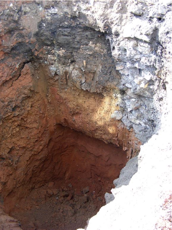
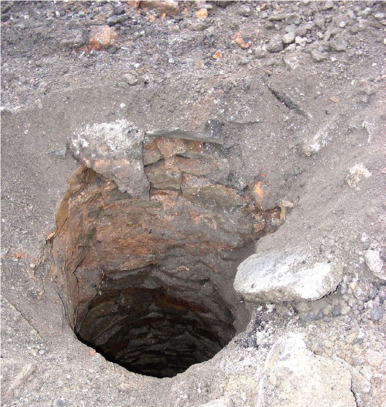
The three wells that were revealed during the watching brief, (118), (171) and (175), were also unmapped, but neither, interestingly, did they relate to any pumps that were mapped by the OS on both its 1:500 and 1:2500 scale maps. Well 118 may have been within a building, but this did not apply to the other two, and one of them (175) seems to have been subject to repair into modern times (20th century?). Apart from anything else, under different circumstances, these features may have constituted important archaeological resources in their own right, in terms of their unexplored fills – wells are an extremely common find in urban contexts, and when they can be explored archaeologically, the results can be enlightening. The recent very extensive Cabot Circus excavations in Bristol revealed numerous wells, although virtually none of them could be explored down to their crucial primary fills; on Hanover Street, however, the recovery of a large assemblage of 18th-century clay tobacco pipe material from a well within a house shows the potential of this kind of deposit (Ridgeway and Watts 2013, 113).
Unlike the Cabot Circus excavations, all the evidence points towards Lamb Grounds/Crotwells being pretty much literally a 'greenfield' site when Nathaniel Wade first began to exercise an active interest in it in the first decade of the 18th century. This is very much reinforced by the findings of the ceramic analysis for the present site – no less than 98% of the material by sherd count, dated to the 18th century.
Questions about its very earliest origins do remain, most notably the date of construction of the so-called Traitor's Bridge across the Frome, which most accounts regard as a prerequisite for Wade's development. Some authorities give a date of 1711 for the establishment of the bridge, but since as we now know from the documentary record that development had begun by 1707 at the latest, it may be that it is time to revisit that date. Wade Street itself may perpetuate the line of a Roman road, and again, one must wonder whether vestiges of that feature survived as late as the early 18th century; a corollary of which would be that the crossing point of the Frome at its north-western end was not new at all, but merely re-established a pre-existing bridging point.
The open, unused nature of the site prior to the advent of Wade's plan, seems to be borne out strongly by its ceramic record. A total of only 13 sherds of pottery of medieval or early modern date were recovered from the entire site, from six different contexts. Of those, the pottery was residual certainly in three, and probably four, of them – (1158), from Area B, produced two sherds of medieval ware, but appears to be stratigraphically later than wall (1043). As we have already noted, only (1193) and (1118) might be considered to be medieval and/or late medieval/early modern contexts, but even then the actual numbers of sherds are very small – four from each deposit (Appendix 2). The excavator of (1118) considered that it was not an occupation deposit as such, but that it represented a natural accumulation of material. A high silt content may indicate that it was a flooding deposit, associated with marshy, meadow-type fields on the Frome floodplain. This would have been a relatively dynamic environment, and if there was occupation not very far away, we might expect some pottery or other artefacts to find their way into it. The nearest occupation to the site prior to the early 18th century was immediately to the south, and upslope (i.e. the southern flank of the Frome valley), along the Old Market/West Street axis). In this regard, it is very interesting to note the evidence of John Rocque's Bristol map of 1740. Rocque was very careful, as best he could, to indicate local topography by means of shading. By this method, he shows that the site of Wade's development was carefully chosen in so far as it was fitted in between two breaks of slope, indicating the existence of a natural terrace extending from just to the north of West Street to the north-western side of Great and Little George Streets. Those latter streets are, in fact, 'perched' just on the crest of one of the breaks of slope, the land then falling away to the north-west to the Frome river, and they exactly follow the alignment of that natural crest. It becomes quite clear that the overall orientation of the development in terms of its major street alignment, which is north-east/south-west, was governed directly by the pre-existing orientation of what is clearly a river terrace lying south-east of the Frome.
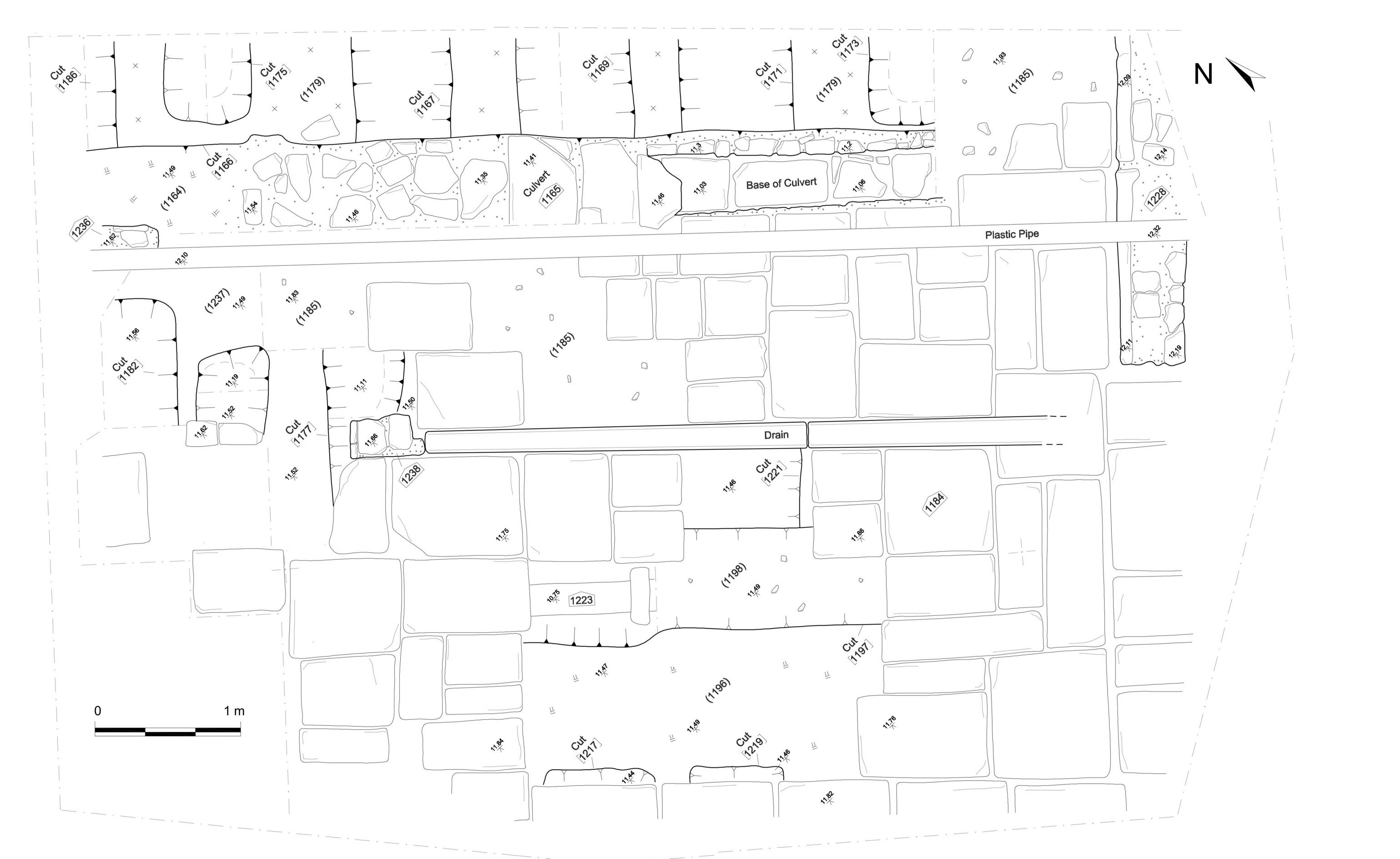
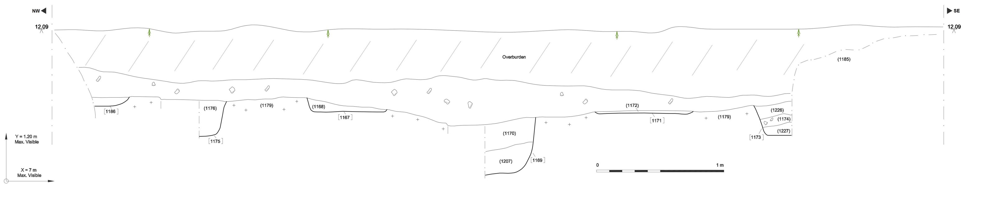
It is difficult to be certain about the date of the earliest archaeologically traceable activity on the site in terms of actual features. In Area C, the series of linear cuts, possibly for market gardening purposes, that begins the sequence there, represent stratigraphically the lowest traceable features (Figures 31 and 32). However, finds came only from a single example, fill (1181) in cut (1180), and there were only two of them; while both were considered to be 18th century in date, neither could be dated more closely than the second half of that century (see the Glass report, Appendix 4; Figure 41).
There does not seem to be any obvious direct correlation in the structural phases between any of the excavated areas. We have suggested that wall (1043), Area B, represents the primary, probably early 18th-century building activity on the site, through its deep footings and very substantial nature, but none of the finds from the lower contexts that were banked up against it were closely datable (Figure 22). There is no direct analogue to this feature on any other part of the site, and it is very noticeable that its line can be projected so as to be picked up exactly by property boundaries to the north-west of Little George Street, and to the south-east of Little Anne Street. For the latter, the boundary emerges onto the north-western side of Lamb Street, albeit with a very slight change of alignment close to its south-eastern end. The fact that the alignment actually runs across both Little Anne and Little George Streets suggests very strongly that it represents a primary feature within the local built landscape in this area, and one explanation may be that it represents the base line from which at least a part of the development area on the north-eastern side of Wade Street was initially surveyed and laid out.
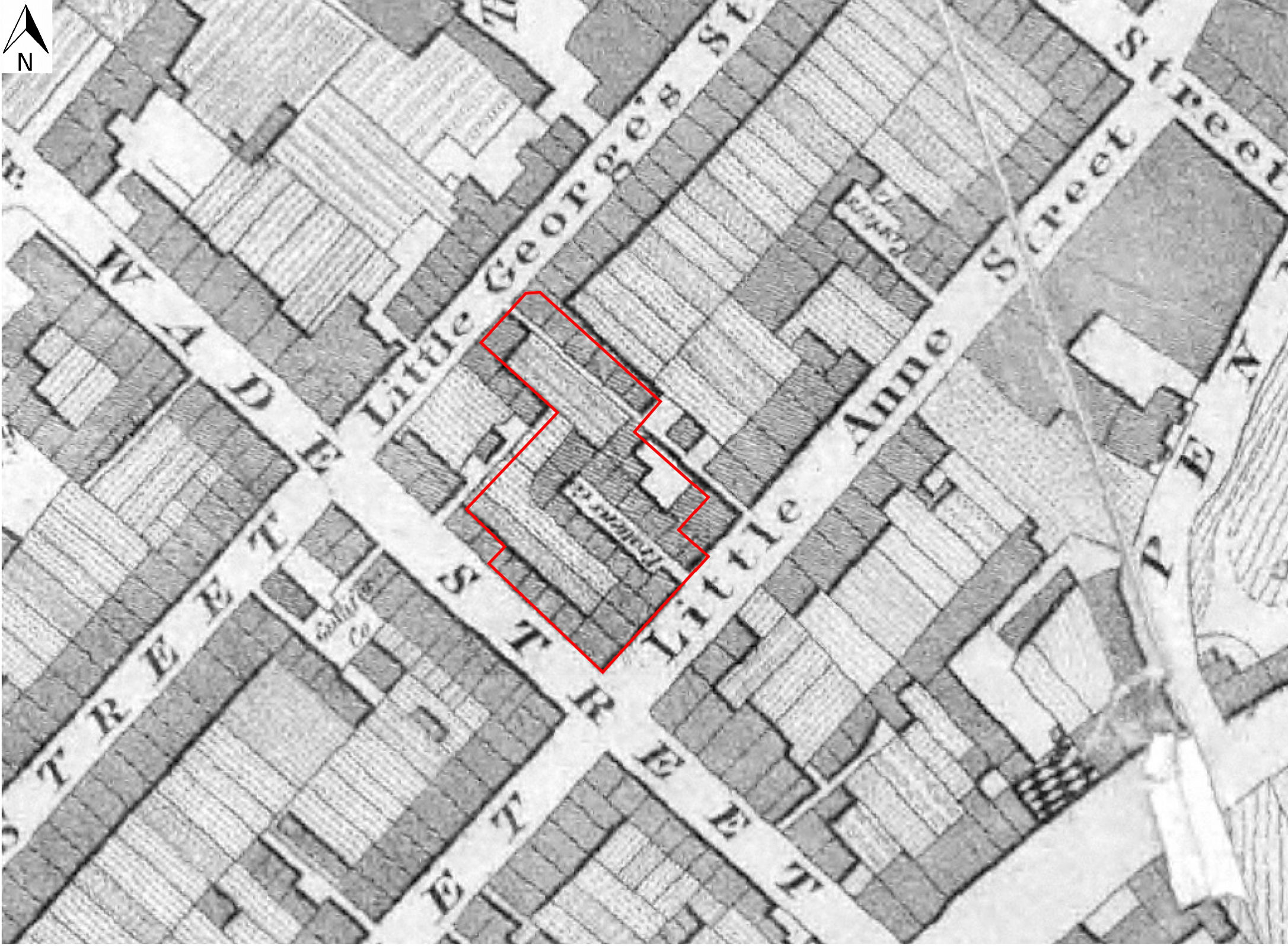
In Area A, notwithstanding some pre-structural phase cuts towards its western corner, the earliest structural evidence may be represented by wall (1010), extended to the north-west in the course of the watching brief by wall (146) (Figure 3 and Figure 11). It is not possible to say for sure whether these two apparently 'primary' walls are contemporary, but one's view on this turns on whether or not it is considered that Pratten's Court was or was not an original element of Wade's development, for there are two possible interpretations in this respect, arising from the fact that both walls are incorporated as elements of the court. Wall (1043) in Area B may have represented the very first structure on the site, intended to act as a main spine wall for building plots on both sides of it, which may have involved the erection of house walls butting against it at right-angles as and when building plots were developed. We have already noted that, on the basis of the very earliest leases, it is probable that building plots were framed around a 'standard' size of 16ft in width, and 80ft in length; and we have also noted that the distance from the Wade Street frontage, north-eastwards to the 'spine' wall (1043), is almost exactly 80ft. This means that if properties on the Wade Street frontage were originally endowed with tenements of this length, then Pratten's Court cannot, by definition, have been part of the original plan. This view would see early houses fronting onto Wade Street having gardens/yards that extended north-eastwards all the way back to wall (1043), to butt against its south-western elevation, and Pratten's Court inserted only later as an intrusive element by, say, 1800, with a new 'spine' wall (1010)/(146) defining the street frontage of the houses on the south-west side of the court, and with the antecedent major property boundary represented by wall (1043) being used in a new function as the rear common north-eastern wall for the houses on the north-eastern side of the court. The common frontage wall of these houses, facing onto the court (i.e. on their south-western sides) was identified in only a single location, and that during the watching brief, as wall (137). This suggestion is apparently contradicted by Ashmead's first map of Bristol (1828; Figure 4), which, as we have already noted, shows plot boundaries running south-east/north-west from the Little Anne Street frontage, and indeed the orientation of the long axis of Pratten's Court is in the same direction, which may suggest that this orientation is 'primary' within the development.
While there is no reason to disbelieve Ashmead's cartographic account of the site, we should always be aware of the possibility that his depiction of both buildings and plots contains more than a small element of impressionism about them. We might, then, by this view, expect to be able to recover, either cartographically and/or archaeologically, traces of boundary alignments running all the way through from the Wade Street frontage to the south-western side of the main spine wall (1043). And on the 1:500 OS plan of the early 1880s (Figure 8), one can trace alignments that seem to run straight through from the Wade Street frontage to the houses on the north-eastern side of Pratten's Court. Specifically: from 34 Wade Street to 9 Pratten's Court; 32 Wade Street to 8 Pratten's Court; 30 Wade Street to 7 Pratten's Court; and 28 Wade Street to 6 Pratten's Court. It is regrettable that, because of the constraints of the site and of the excavation area, there was no opportunity to test archaeologically for the presence or absence, in 'open' areas outside the houses themselves of long, antecedent property boundaries, perhaps in the form of walls, running all the way through from the Wade Street frontage to meet the south-western side of primary spine wall (1043).
The alternative narrative is that Pratten's Court was, from the outset, an original element of Wade's development, and that therefore walls (1043) and (1010)/(146) should be seen as broadly contemporary. As we have already seen, Dr Leech has demonstrated that small, working-class courtyard developments began to appear in Bristol from the 17th century (Leech 2014, 187-89). We know from the documentary record that at Lamb Ground/Grotwells, Wade was selling off, piecemeal, individual plots for single houses, but this does not exclude the possibility that Pratten's Court, which was clearly constructed as a coherent, unified group, was inserted into an open space behind the Little Anne Street frontage by a well-off builder at a very early stage in the development. Unfortunately, the excavation did not produce enough evidence, in terms of dating and phasing, to answer this question unequivocally either way.
Because of the physical constraints of the site, it was not possible to explore to any great extent at all the physical nature and development of party walls between properties in either Pratten's Court or the Little Anne Street frontage. The Wade Street frontage was a complete blank in this respect, since it did not figure in the excavations, although during the watching brief a few fragments of intermittent walls were identified in this area (Figure 3). We consider that it has, though, been possible to cast some light on the nature of the relationship between 1 Pratten's Court, and 6 Little Anne Street, as the excavation of the latter in the form of wall (1023) seemed to show quite clearly that it was butting against the former (Figure 11). The census records seem clearly to show that at some point in the middle of the 19th century, and certainly by 1861, 2, 4 and 6 Little Anne Street were rebuilt, perhaps as a group, because in that year they were not recorded in the census. Indeed, even in 1851, in what we think is this part of Little Anne Street (the census records are not entirely clear), one house is recorded as uninhabited, while another is actually described as 'building', i.e. under construction. Be this as it may, all three houses, fully occupied, had reappeared by the time of the 1871 census. If we allow that 6 Little Anne Street was, therefore, rebuilt at this time, its relationship to 1 Pratten's Court, as recovered archaeologically, can be explained; and it may also be that it was during this rebuilding that 6 Little Anne Street was provided with the brick-vaulted cellar (1026) that was also recorded during the excavation.
The genesis of the hard surfaces in Areas A and B is likewise somewhat problematic. Flagstone paving (1007), butting against wall (1010), sealed deposits containing overwhelmingly 18th-century pottery, most notably (1114), but this of course does not date the hard surface above it, and indeed the redware pottery also recovered from this layer was still current into the 19th century.
It is, then, an important question in Area A whether the hard surfaces (1005)/(1007) were only added subsequently to Pratten's Court, or whether they were part of the scheme from the start. On balance it seems far more likely that they were associated with Pratten's Court from the outset. It is of course possible that the court was initially only provided with rammed clay surfaces, or something similar, but with residents constantly coming and going, in persistently wet weather such surfaces would rapidly have become a dangerous, unsafe and unhealthy quagmire, and quite intolerable for practical use. While we may note that a very few of the ceramics found in contexts sealed by the cobbled and paved surfaces here, strictly speaking may extend from the 18th century into the 19th, it seems far more reasonable to be guided by the overwhelming majority of the fabrics, which are firmly 18th century in date (Appendix 2). By this view, the layers sealed beneath the hard surfaces, from (1114) upwards, are levelling deposits dumped over a relatively very short space of time, for the express purpose of laying the cobbles (1005), their kerbing (1240), and associated flags (1007), and are of 18th-century date; so that Pratten's Court, then, is also of 18th-century date, although when in that century unfortunately remains problematic. Dr Leech does not say anything about the surfacing of these small courtyard developments in Bristol during the 18th and 19th centuries; it is clear, however, that there was precedent, which was in fact almost certainly very widespread from the second half of the 18th century onwards, for the use of behind-frontage gardens for subsequent expansion of development precisely in the form of small courtyards, and Pratten's Court should probably be viewed against this general perspective. Dr Leech quotes one such example called 'New Buildings' in St Nicholas parish, which:
was built behind the street frontage c 1786 in an existing garden and extended back to Deep Street … The design of the uniform frontage to the new side street was of an entirely domestic character; behind the façade were at least six one-room deep houses of varying size. In Gay's Court behind … Temple Street at least five similar, one room deep houses of varying size had been built by 1789. Though of varying plan and possibly built over a period of time, all were entirely residential in character … similar developments in courtyards can be seen on plans of properties in Queen Street in 1742 … and at … Redcliff Street in c 1816-1817, where Warry's Court was a development of eight one-room plan houses, probably of about c 1755 (Leech 2014, 188-189).
It is worth reiterating that, regrettably, the archaeological evidence from the Wade Street site does not allow sufficient resolution to establish a detailed evolutionary history of the structures that were uncovered, and again as we have already noted, this was only compounded by the lack of a complete ground plan of even a single house from the site. An important strand of Dr Leech's examination of the evolution of small, very modest artisans' houses in Bristol was a progressive change, from the 1740s onwards, from the one room to the two-room ground plan, a development also seen historically in other large British cities. Dr Leech notes that:
It is noticeable that houses built in courtyards in the 19th century were smaller in size than the artisan houses of an earlier era: by 1800 the one-room plan had declined in status (Leech 2014, 190).
The clear inference of this remark is that although the number of rooms was greater, occupants may actually have had less space at their disposal with the two-room plan. At Wade Street, it is only at 1 Pratten's Court, in its extreme southern corner, behind the houses fronting onto Little Anne Street, that we have enough of a ground plan to suggest that this was, in origin, a one-room house, delineated by side walls (1017) and (1018)/(1019); (Figure 11). It is notable that the distance between these walls is only 3.5m (11½ft), thereby failing to come up to the 16ft plot width which, as we have already seen, was specified in the very earliest of the surviving leases for Nathaniel Wade's original scheme. There did not seem to be any evidence of internal partition walls as excavated, but of course, there is always the possibility of truncation at rather higher levels, especially if such walls were only flimsily constructed. One wonders therefore if Pratten's Court represents something of a transitional phase between the full abandonment of the one-room plan, and the appearance of its two-room successor, and which from the evidence presented by Dr Leech, should be no later than about 1800 in date and, here at Wade Street, is likely to be earlier.
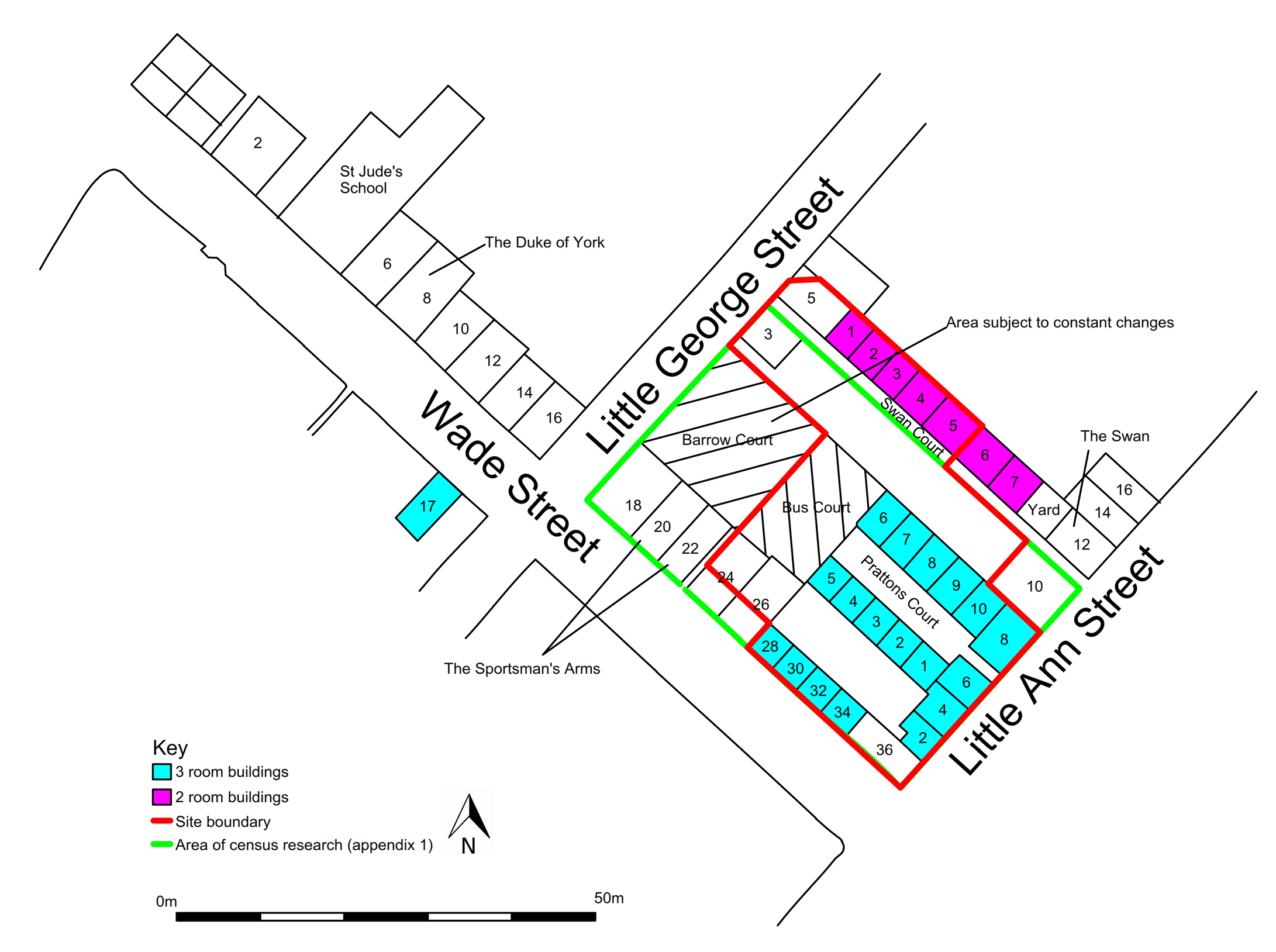
We know a surprising amount about the demography and social and economic affinities of the little Wade Street community from about the middle of the 19th century onwards, thanks to an analysis of census records undertaken by Rachel Heaton as part of this work. What is clear is that in some cases the incidence of overcrowding in some of the properties in the second half of the 19th century must have been appalling – 14 Little Anne Street, although just outside the strict boundary of the excavation site, is a case in point. In 1881, a date virtually coincident with that of the First Edition 1:500 OS plan, there were no fewer than seven separate families, plus a single person, living there, amounting in all to a total of 32 people, of all ages, in this one property.
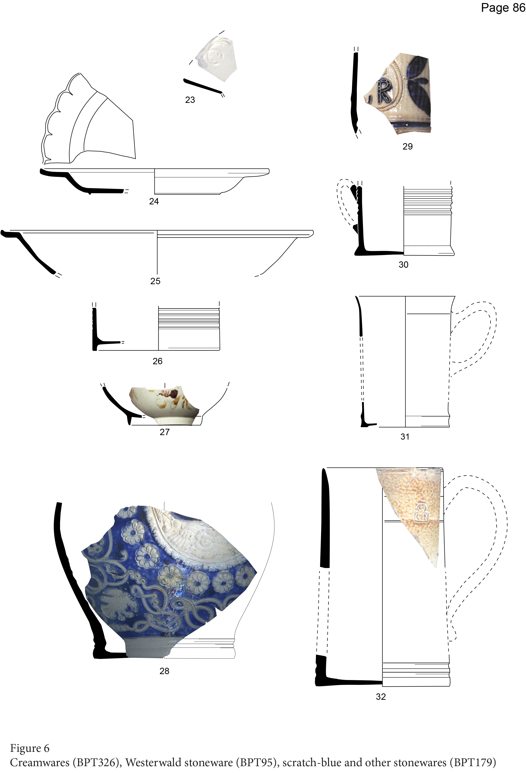
As outlined in Appendix 2, the ceramic assemblage was predominantly of 18th-century date, and likewise overwhelmingly domestic in nature. The recovered fabrics represent the type of vessels:
Such as those required to store, cook and serve foodstuffs at the table (Gutiérrez 2014).
The lack of large quantities of clear 19th-century fabrics might suggest that hard ground surfaces, from which domestic refuse was regularly swept, were in place by then. As a group, however, there is little in the assemblage that can allow us to make direct inferences about the social status of the occupants or their economic circumstances, but only because of the relatively small size of the dataset. There are hints, most notably in the form of a relatively large proportion of plain but fine creamwares from, essentially, the second half of the 18th century (Appendix 2, Figure 48, Fabrics 23-27). These fabrics represent:
A finer type of crockery that was to become the choice for serving and consuming food at the table; this would supersede the lead-glazed wares with time (Gutiérrez 2014).
These fabrics may represent some level of domestic pretension on the part of some of the former occupants of the site, notwithstanding the clear historical evidence of the census records, which underline very strongly that, at least by the mid-19th century, this was not a wealthy community (its membership generally drawn from the class of minor artisans, labourers, and other unskilled workers).
As far as the glass is concerned, it would be difficult to make any meaningful inferences from the relatively small number of wine bottle fragments recovered from the site, which in total may well represent only a handful of complete vessels. In view of the relatively well-established history of the site, it is most likely that all of the wine bottle glass dates from the 18th century rather than the 17th, but its presence should not be surprising even on a site of such relatively lowly social status as this, given that Bristol remained a major centre of the wine trade at this time. We also cannot know exactly what kind of wine was in the bottles represented by these fragments – it may have been very poor-quality stuff indeed, easily available even to someone commanding extremely modest resources. The quantity of post-medieval bottle glass from Wade Street is, however, put into perspective when considered against the equivalent material from the massive Cabot Circus Project – despite its sheer size, that work recovered only 185 fragments of what the specialists call 'common English bottles'; they remark, in concluding their assessment, that:
It is unfortunate that the glass from Cabot Circus sheds very little light on the activities during the post-medieval period. It is evident that there are many bottles for the storage of alcoholic beverages, but such vessels are commonplace and to be expected. The fragmentary state of the glass is perhaps worthy of note, perhaps the area was being kept clear of bulk debris for the 'comfort' of the residents (Shepherd and Willmott 2013, 245).
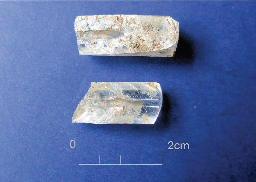
We may wonder, then, whether the same strictures might be applied to the post-medieval bottle corpus from Wade Street. Depending on how we interpret the evidence, the glass may, though, present a tantalising hint of curation, in the form of fragments from a bowl of olive-green glass (Glass Catalogue no. 12). This is dated to the first half of the 17th century, and while of course there may be any number of ways in which its remains may have found their way onto the site, it is not impossible that it was brought in as a family heirloom, particularly so in view of the fact that it seems to have been a relatively uncommon type of vessel even on a national scale.
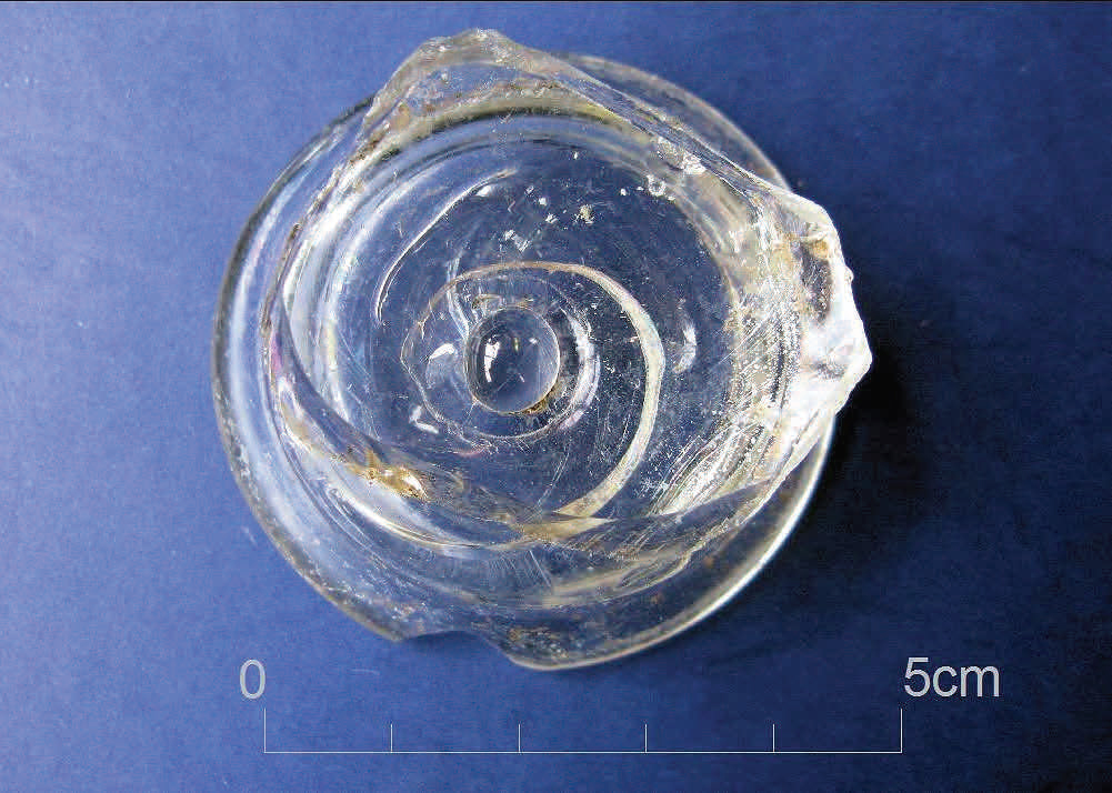
The most unusual glass artefact recovered from the site was a short length of thermometer or barometer, dating almost certainly to the 18th century, both on morphological grounds, and from the fact that the context from which it came contained overwhelmingly 18th-century ceramic material (Figure 42).
However, while interesting in a general sense, it unfortunately tells us little about the ability or otherwise of a member of the supposedly working-class Wade Street community to acquire what, on the face of it, might be thought a rather high-status and esoteric object; unless, of course, it had been something of an aspirational purchase, intended to display pretensions to a social status rather higher than was perhaps usual in that area. But the possibility that it may have been produced by a Bristol instrument-maker raises the prospect that it has not travelled all that far from its place of manufacture.
We should, however, always bear in mind that de-gentrification is a well-known feature of historic urban social development – the process by which an area is first occupied by newly constructed houses intended for occupants of a certain social scale, but which through time, and for many and varied reasons, progressively declines in fortune and comes to be occupied by dwellers of a rather more lowly standing. Clearly, as the census study here shows, by the mid-19th century, the Wade Street site does appear to have been occupied by the latter class of society; but this certainly need not necessarily have been the case a century or more earlier, and it is overwhelmingly that earlier period, rather than the 19th century, which is represented in the material culture from the site, such as it is. We should not read too much into these few small glimpses of what might represent aspiration and tendencies towards social pretension on the part of an earlier stratum of society occupying the excavation area, but it may represent some small evidence that people living on the site during the latter years of Queen Anne, and then through the reigns of the first three Georges, really were, simply, better off, and were also, or at least perceived themselves to be, of rather more elevated social status than was the case in Queen Victoria's reign, and indeed later.
Overall, it has proved difficult to make direct inferences about how if at all the witness of the historical records can be made to cast light on what was found during the archaeological work on the site. The constraints of the site, which meant that the excavation was confined to three specific areas, played a role in this, but likewise the archaeology had its own, very important, story to tell. This included the provision of cellars for at least some of the properties; a cistern; backyard wells providing water supply, albeit of uncertain date, and perhaps, later on, accessed by pumps that are not depicted on the large-scale OS plan; evidence for what may well be the remains of the stock in trade of a clay tobacco-pipe maker who can be identified by name, and whose location in 1871, at a small cottage behind 26 Wade Street, later part of Buss Court, is known from the census records (Appendix 1). There are hints from the documentary record, however, that certain elements among this list may not have been uncommon within the dwellings of the St Jude's community, and very occasional room by room descriptions of houses, albeit rather late in date, do give some impression of the actual living conditions within. A good example is a valuation of a house at 6 Wade Street, further to the north-west of the excavation site towards the Frome Bridge, although on the same side of the road. Written in April of 1882, it describes:
All that freehold messuage or dwelling house yard and premises situate and being No. 6 Wade Street … belonging to and in the occupation of Mr James Dalton. The house contains on the second (semi attic floor) two bedrooms; first floor ditto; ground, two sitting rooms and pantry, shed and yard with well; basement, kitchen and cellar with separate cistern. The building is in poor repair but clean. The premises are subject to a ground rent of 13s 4d, and a land tax of 1/8 per annum. I am of opinion that the value of the same is the sum of … £220 (BRO 37918/D/3/2/23).
This estimate turned out to be not so far wide of the mark, because in July of the same year, Dalton conveyed the property to a new owner for the sum of £250 (BRO 37918/D/3/2/24). No. 6 Wade Street was removed at some date towards the end of the 19th century or the first few years of the 20th, to provide additional space for the parish school that had been founded immediately to its north-west some time around 1860.
In any event, the general image of, effectively, three storeys that is lent by this valuation, seems to chime pretty well with what Dr Leech, as we have already seen, has outlined for the houses in this area, taking as his model one of the only two surviving examples, 17 Wade Street. The two upper storeys clearly supported multiple rooms by this date but there is nothing to say that they did not start off in the most basic configuration of single rooms stacked one above the other. Mention of a cellar, a well and a separate cistern are also significant as, of course, all were archaeologically attested on the excavation site; and the suggestion of the kitchen being actually in the basement places this particular house firmly in the mainstream of developments that had their origins in far more prosperous areas from the second quarter of the 18th century, and which, indeed, gave rise to an arrangement in which basement kitchen and vaulted cellar were consciously placed together, with access between them, sometimes the one, and sometimes the other at the rear of the house. Dr Leech notes of this arrangement that:
The same plan, of basement kitchen at the rear and vaulted storage cellar to the front, was used during the 1780s in the construction of houses in College Street. In the new rows of terraced houses constructed or commenced in the building boom of the early 1790s, the placement of the kitchen in the basement was universal (Leech 2014, 315).
On the excavation site, we have the cellar at a location formerly occupied by 6 Little Anne Street, possibly, as we have already noted, the result of a rebuild (Figure 11); the cellar is clearly at the rear of the building, away from the street frontage, so one wonders, therefore, whether the kitchen for this house might have been expected to be revealed had it been possible to excavate rather further to the south-east, into the modern pavement and road area. Conversely, the cellar identified from the watching brief (Context 103), which seems to have been associated with 2 Little Anne Street, notwithstanding the practical difficulties of the site during the course of that work, appeared to have had a solid rear wall with no discernible doorway into another room that might have been a kitchen (Figure 3); it was, then, presumably entered by a stair from the ground floor, as indeed was the cellar in 6 Little Anne Street.
Relationships within the structural elements of the site reveal a complex, albeit rather partial picture of rebuildings, partitions of existing structures, and other alterations and changes, the purposes and contexts of which are not always clear. In the elucidation of the archaeological evidence, the surviving historic map material is of limited use, for the reasons that only the outlines of buildings are shown, and there may also be questions about the veracity of some of the surveying. Arrangements for sanitation within the excavated areas were hardly discernible, although what was identified as the earliest structural phase in Area A may have included the remains of an outside privy, as implied by the nature of its fill. One wonders if the ground floor 'shed', in a yard, already noted from the documentary record at 6 Wade Street in the late 19th century, was exactly such a feature. During the watching brief, a likely cess deposit was also found, but only as part of a probable midden deposit of indeterminate source. Dr Leech remarks that:
In poorer areas of the city, privies were sited over water courses where possible … It is not known when the water closet was introduced, either on the residential plot as a whole, or, more significantly, within the house itself (Leech 2014, 318).
On balance, it is improbable that even external WCs were available to the residents much before 1900, although it is just possible that some of the small outbuildings depicted on the large-scale OS plan of the early 1880s, such as that shown behind 3 Pratten's Court (Figure 8 and Figure 21), are at the very least earth closets, or perhaps Rochdale-type pail closet privies (Eveleigh 2002).
Internet Archaeology is an open access journal based in the Department of Archaeology, University of York. Except where otherwise noted, content from this work may be used under the terms of the Creative Commons Attribution 3.0 (CC BY) Unported licence, which permits unrestricted use, distribution, and reproduction in any medium, provided that attribution to the author(s), the title of the work, the Internet Archaeology journal and the relevant URL/DOI are given.
Terms and Conditions | Legal Statements | Privacy Policy | Cookies Policy | Citing Internet Archaeology
Internet Archaeology content is preserved for the long term with the Archaeology Data Service. Help sustain and support open access publication by donating to our Open Access Archaeology Fund.