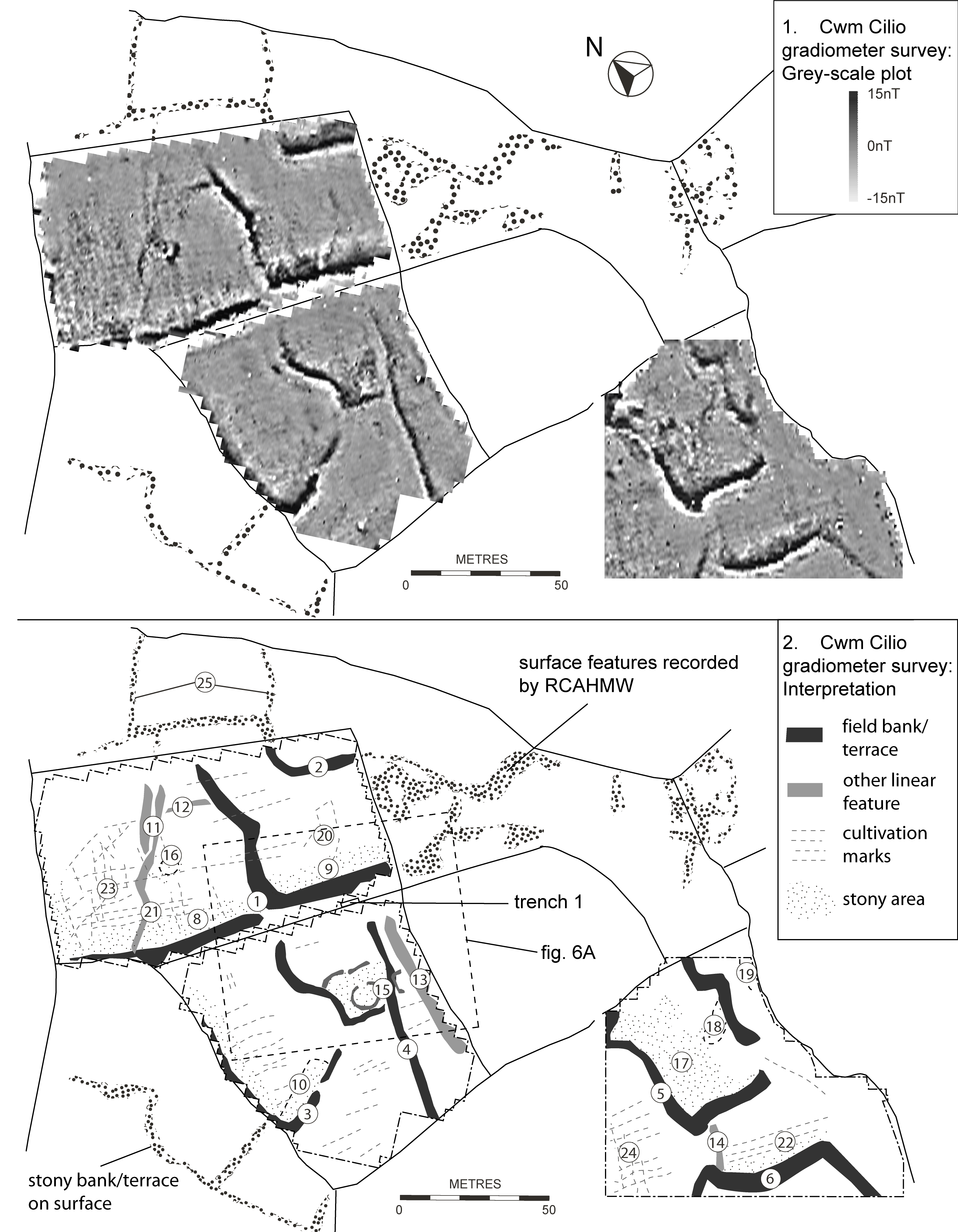
The study, and in particular the geophysical survey, have added more detail to the previous plan of the field system by the RCAHMW (1960, 106). The early field pattern has elements of rectangularity but with some sinuous boundaries and gives the impression of having developed in an organic manner rather than being laid out to an overall plan. The contour terraces are of a substantial height and must contain substantial amounts of material. The individual plots have rounded downslope corners and angular upslope corners. Some of the major boundaries cross the contour at an angle so that there is some terracing even on cross-contour boundaries.
In a few places there are 'secondary' subdivision boundaries comprising simple banks without terracing (Figure 5.2, 11) and some boundaries on the steeper, stonier hillside are just lines of stones (Figure 5.2, 25). The excavated bank overlay a buried soil and micromorphological study identified this as cultivated colluvial soil above plough-eroded brown earth subsoil. It shows, significantly, that this area was cultivated before the field system was created and was chosen for cultivation because of its better-drained soils that were less acid than most local soils. Comparison of the buried soil with the micromorphology of a sample from trial pit 3, to the west, which was not a buried soil, but probably protected from post-medieval cultivation, indicates that at some point cultivation ceased and the soils acidified. However, trial pit 3 was in a negative lynchet, downslope from a terrace, where ploughing would have cut into the subsoil and so where the soil depth and type would not be typical of the soil of the early field as a whole.
The implications are that this area, occupying a particular topographic place between the steeper, stony slopes and the more level and ill-drained valley floor, once had relatively good soil in agricultural terms compared to the heath and bogs around. Although the original soil was of reasonable agricultural quality, its cultivation led to the clearance of large quantities of stone, which was incorporated in the boundary banks, buildings and other structures, such as the enclosure wall of the nucleated roundhouse settlement.
The system of field boundaries may not have started to take form until cultivation began to deplete the soil and bring quantities of stone to the surface. It could also be that the development of improved ploughing methods intensified the impact of cultivation and encouraged the development of derived colluvial deposits in lynchets.
Indeed, the height of the field terraces suggests that they did not derive simply from gradual accretion of plough soil. The face of the terrace immediately above the excavated trenches was stony, suggesting that it was a stony bank which may have gradually accreted as clearance stones were dumped and soil built up behind it; the presence of such stony banks was supported by the geophysical survey (Figure 5).
There are several hollow platforms within the field system as well as terraced areas that seem too small to be fields. The geophysical survey has shown that one of the hollows is probably a quite large roundhouse, 8–10m in overall diameter. The platforms of several other possible roundhouses have been identified within the field system, platforms which appear to have been abandoned and incorporated into the fields. It is therefore likely that these scattered houses belong to a phase of unenclosed settlement predating the nucleated enclosed settlement at the centre of the field system.
Trackways and entrances are not readily identifiable within the field system although several fields have considerable gaps in their boundaries which suggest a system of interconnecting fields rather than individual enclosures with gated gaps. This corresponds with an 'in-field' system of cultivation with any stock mainly kept in open land beyond. The largest and most distinct feature is the terrace that continues right across the hillside just below the enclosed settlement. This long terrace cuts across several cross-contour boundaries with no indication that there were earlier gaps and so represents a secondary phase. The geophysical survey (Figure 5) shows a gap in the boundary at the field corner at the terrace junction 1, which may be simply an access ramp between fields, necessary for cultivation.
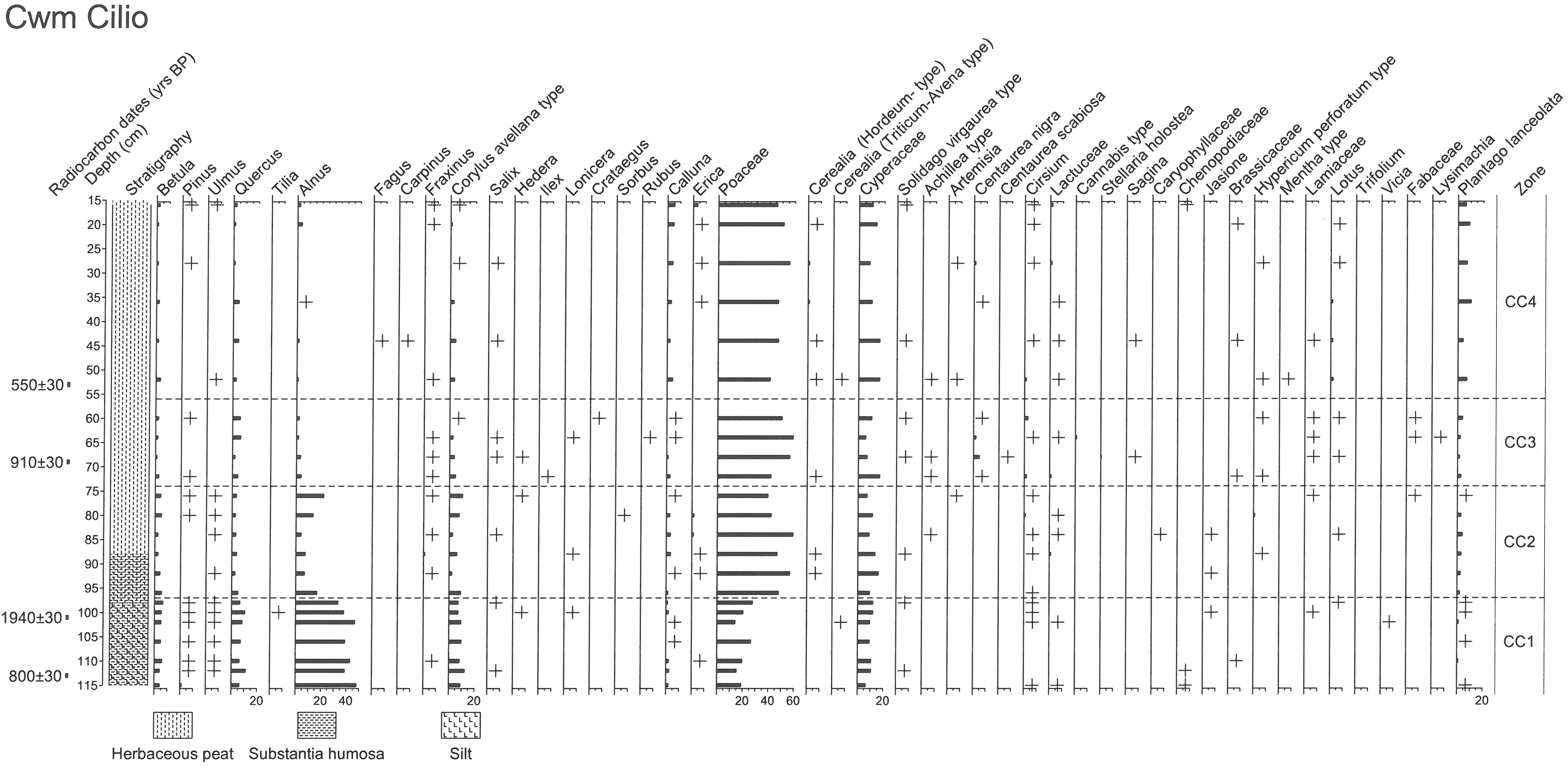
Two charcoal samples from the buried soil below the bank in Trench 1 produced AMS radiocarbon dates. One, of hazel, produced a date of 3505±30 BP (SUERC-33062), 1910–1740 cal BC at 95% probability. The other, of oak, produced a date of 6135±30 BP (SUERC-33063), 5210–4990 cal BC at 95% probability. These dates are confusing and difficult to explain. If the buried soil had been a natural soil then the charcoal might have derived from clearance prior to the start of the enclosed elements of the field system. However, it is clear that the buried soil was cultivated, so the hazel charcoal, dating to the early 2nd millennium cal BC, may represent clearance of secondary woodland for a phase of cultivation prior to the establishment of the field system. The earlier radiocarbon date from the oak charcoal may derive from an earlier phase of primary woodland clearance, which is supported by the soil pollen evidence. Woodland cover would be expected here as a natural climax vegetation, and burning to open up the woodland in the later Mesolithic has been identified from pollen studies elsewhere in upland Wales and England (Caseldine and Hatton 1993, Caseldine et al. 2017) but the pollen column from nearby peat deposits at Cwm Cilio did not extend to this early period.
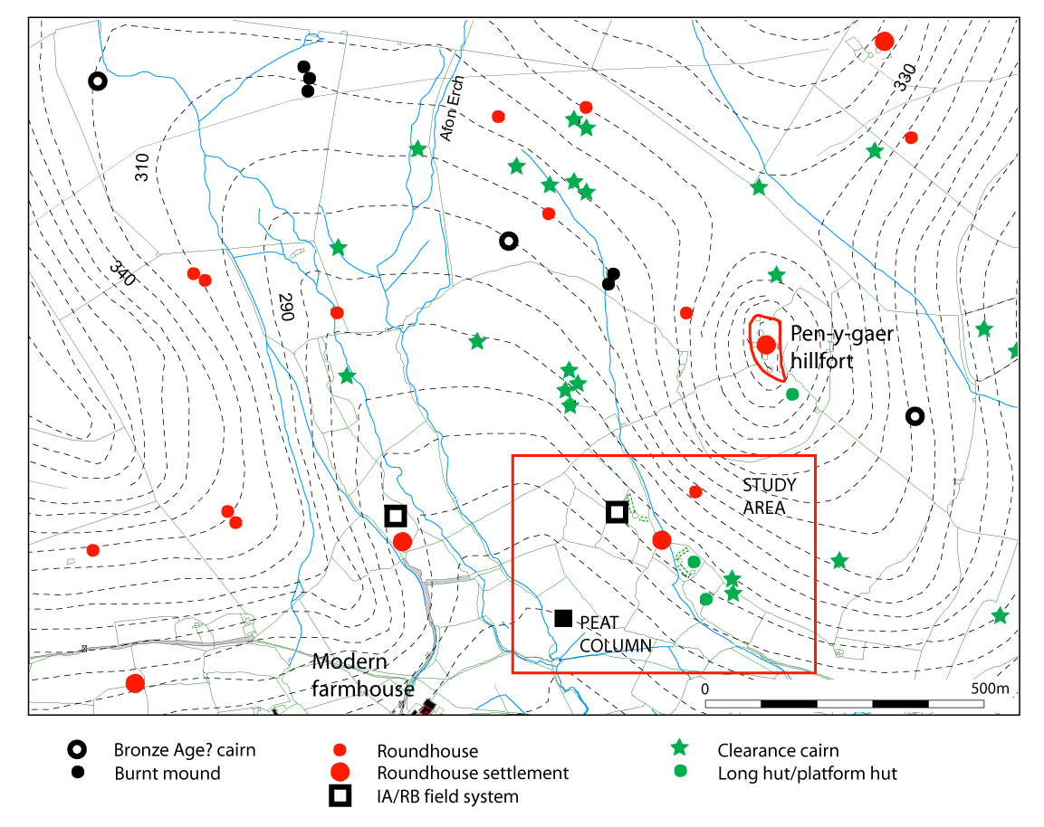
The identification of a brown earth soil on site shows that there was once woodland here which produced a soil of reasonable fertility. If the Early Bronze Age date does relate to this previous phase of cultivation it is significant considering the general lack of knowledge about the location of settlement and of fields of that period in North Wales. There is certainly evidence of activity during the 2nd millennium BC in the immediate area in the form of burnt mounds and burial cairns higher up the slopes (Figure 2) and of a standing stone lower down the valley. By comparison with landscape studies in the Peak District of Derbyshire, any settlement of the 2nd millennium BC would be of scattered, unenclosed roundhouses (Barnatt 1987). There is also some evidence from North Wales that such houses would have been more likely to have been built with timber walls (Kelly 1988). Their remains would be more difficult to identify in the archaeological record than those of houses with stone walls and might be best identifiable as platforms, like those within the field system at Cwm Cilio. Gradual clearance of woodland has been documented as a major impact on the upland landscape in North Wales through the second and first millennia BC (Chambers and Price 1988, 99) and would have meant scarcer resources of timber for house building.
The interpretation of the archaeological evidence must be seen in parallel with the palaeoenvironmental analysis and dating of a column from valley peat just to the south of the field system, which provides evidence about the local environment, including changes in woodland cover and the effects of farming from possibly the Later Bronze Age/Iron Age, or possibly earlier, through to the late medieval/post-medieval period.
The earliest evidence (zone CC1) from the silty basal deposits at Cwm Cilio suggests a relatively open landscape with alder (Alnus), and maybe birch (Betula), woodland on wetter ground in the area, and oak (Quercus), hazel (Corylus avellana type) and birch woodland on drier land (Figure 8a, Figure 8b, Table 5). A predominantly grass (Poaceae) and sedge (Cyperaceae) open landscape is suggested, although heather (Calluna) is present indicating acidification of soils in the area. The presence of grassland weeds, such as ribwort plantain (Plantago lanceolate), buttercup (Ranunculus type), tormentil (Potentilla type), bedstraw (Rubiaceae), docks (Rumex spp), devil's bit scabious (Succisa) and bog asphodel (Narthecium), suggest pasture and that the main land use was for grazing livestock. Some support for this may be provided by the presence of Sordaria sp. fungal spores, but they are scarce and may simply signify rotting vegetation rather than dung and grazing animals. The occurrence of bog asphodel, which as well as being indicative of pasture is another indicator of acidic soils, was traditionally thought to account for brittle bones in cattle and sheep, but was probably a result of low calcium in the soil rather than the plant itself. Evidence for arable activity is scarce, although wheat-oat (Triticum-Avena) type cereal pollen is recorded. Wetter pools are suggested by the presence of pollen of pennywort (Hydrocotyle) and Mougeotia (algae) spores, while polypody (Polypodium), bracken (Pteridium and other ferns (Pteropsida (monolete) indet.) were another element of the vegetation in the area.
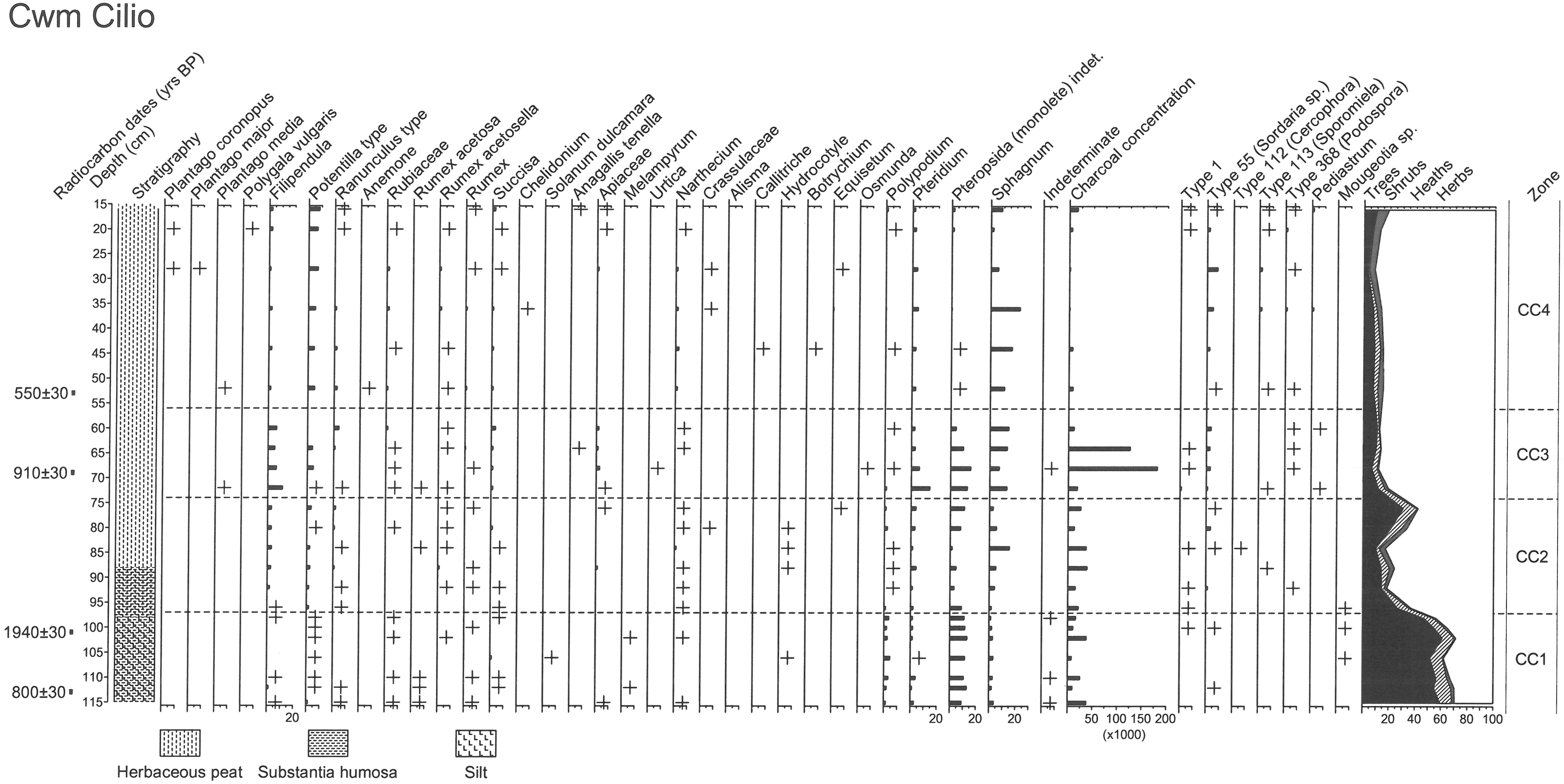
The dating of this first phase is a little uncertain and is also discussed further below. Initially a date (Table 6) of cal AD 1190–1200 and 1210–1270 (Beta-312794) was obtained from near the base of the pollen record but a date of cal AD 1030–1210 (Beta-312793) was obtained from considerably higher up the stratigraphy, near the beginning of zone CC3. A further date was obtained from towards the end of zone CC1 and this was cal AD 0–130 (Beta-360404), suggesting that the lower date was contaminated by later material and that the record possibly begins in the Iron Age or Later Bronze Age, or possibly earlier. Alternatively, the first phase is medieval in date.
The date of cal AD 0–130 relates to a period of declining woodland, principally alder, following a brief increase; this may indicate an expansion in activity in the area, perhaps associated with the nucleated roundhouse settlement and sub-rectangular terraced fields. The cereal pollen evidence also dates to this period. Cereal-type pollen tends to be under-represented because most cereals are self-pollinating and the large grains are less likely to be transported. Hence this might account for the limited signal in the pollen record, along with perhaps local alder affecting representation of other pollen types through filtering or over-representation. A small peak in charcoal concentration at this time might also relate to the settlement, whilst earlier peaks in charcoal and evidence for livestock farming might reflect activity associated with the hillfort to the east.
Impact of human activity on the local woodland and elsewhere in the area may have affected drainage and shortly after this date, stratigraphic changes occur and a wet herbaceous peat develops with pools indicated by the continuing presence of pennywort. An expansion in grassland (zone CC2), probably in both dryland and wetland habitats, and decline in woodland, mainly alder and oak, is accompanied by a slight increase in ribwort plantain, estimated as occurring during the Roman period. Other taxa also indicate either dry or wet pasture, including the bog itself. Representation of bog asphodel increases, as does tormentil type and these taxa were possibly growing on the bog surface along with other species such as meadow sweet. A greater range of fungal spores possibly indicative of dung occurs occasionally, including Cercophora sp., Sporomiela sp. And Podospora sp. As well as evidence for livestock farming there is some possible evidence for arable agriculture in the area. Hordeum-type cereal pollen is present and may indicate barley was being grown in the area but this cereal type also includes certain wild grass species such as sweet-grasses (Glyceria spp.). A slight increase in charcoal, either from settlements or associated with agriculture and land use practices, may reflect increased human activity in the area. This phase is followed by a slight recovery in woodland, mainly alder, hazel and birch, and decline in grassland and ribwort plantain, which might indicate a reduction in activity during the early medieval period. Initially, microscopic charcoal concentrations also decline before then recovering.
A further decline in woodland (zone CC3) occurs shortly before cal AD 1030–1210 (Beta-312793). Herb taxa continue to suggest grazing activity and this is again supported by fungal spore evidence. An increase in bracken could indicate a spread into areas formerly occupied by woodland or a change in grazing regime. Bracken is sensitive to trampling by livestock, particularly cattle, hence a decline in grazing intensity or a decline in cattle grazing compared with sheep, may have facilitated its increase. This is followed by marked increase in microscopic charcoal concentrations and charcoal in the stratigraphy which suggests local burning, including possibly of the bog surface. Common knapweed (Centaurea nigra), indicative of grassland and rough ground, also increases at this time, perhaps invading recently burned areas.
The vegetation changes and the evidence for burning may relate to re-occupation of the area in the medieval period and activity associated with the enclosed rectangular platform house settlement. The evidence suggests livestock farming was the main land use during this period, although there is some tentative evidence for cereal cultivation. Hordeum-type pollen occurs at the beginning of CC3, suggesting cultivation of barley, although it could represent certain wild grasses, and is accompanied by Achillea-type pollen. Achillea spp. include yarrow and sneezewort, typical of grassland, but this pollen type also includes Anthemis spp. (chamomiles) which are typically found on arable land as well as waste and rough ground. A number of other herb taxa, e.g. Brassicaceae which includes taxa such as shepherd's purse and docks (Rumex spp.), could also indicate cultivation. Cannabis-type pollen, probably hemp, is also present; this has been recorded at other sites in the area including Cefn Graeanog (Chambers 1998) and in the wider region at Llyn Cororion, near Bangor (Watkins et al. 2007) during the medieval period.
During the final phase (CC4) increased representation of ribwort plantain, tormentil type and fungal spore evidence indicate the continuation of pastoral farming. The commencement of this phase is dated to c.cal AD 1320–1350 and cal AD 1390–1430 (Beta-360403). Around this date the presence of cereal-type pollen, both Hordeum and Triticum-Avena types, may indicate cultivation in the area though, as before, the Hordeum-type pollen may be derived from wild grasses such as sweet-grass (Glyceria sp.) A slight increase in heather and bog asphodel possibly suggests increasing soil acidification in the area. Low microscopic charcoal concentrations may suggest a decrease in settlement in the area, perhaps reflecting a response to climatic and social and economic pressures.
Internet Archaeology is an open access journal based in the Department of Archaeology, University of York. Except where otherwise noted, content from this work may be used under the terms of the Creative Commons Attribution 3.0 (CC BY) Unported licence, which permits unrestricted use, distribution, and reproduction in any medium, provided that attribution to the author(s), the title of the work, the Internet Archaeology journal and the relevant URL/DOI are given.
Terms and Conditions | Legal Statements | Privacy Policy | Cookies Policy | Citing Internet Archaeology
Internet Archaeology content is preserved for the long term with the Archaeology Data Service. Help sustain and support open access publication by donating to our Open Access Archaeology Fund.