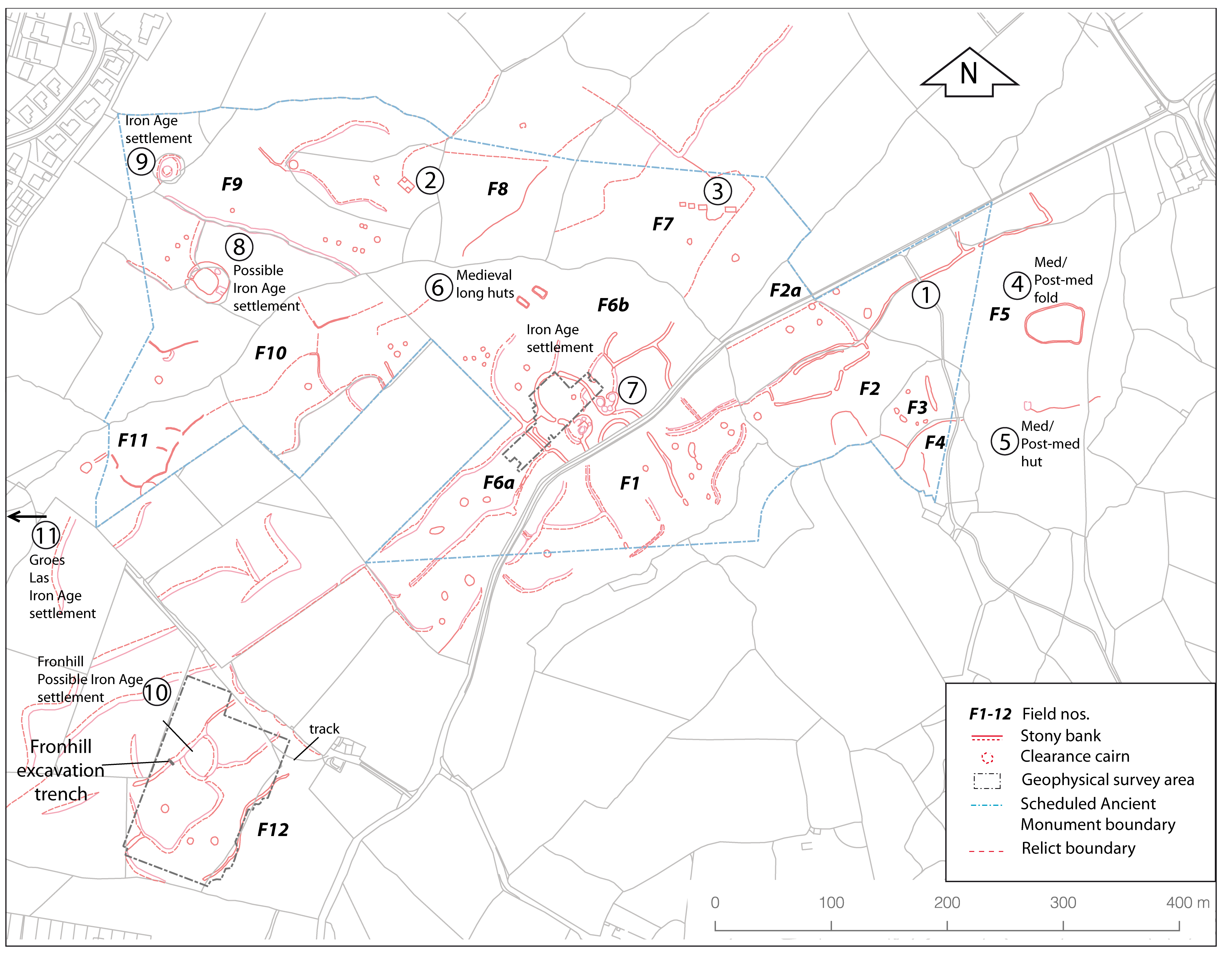
The lack of an overall plan of the whole field system hindered proper interpretation and management. A detailed survey was therefore carried out by R. Johnston using a GPS Total Station. Much of the area is now badly overgrown with bracken and gorse, making survey difficult, but it was helped by plotting from high-resolution monochrome Ordnance Survey vertical air photographs from about 1970 followed by ground checking of detail. More recently, further detail has been added by Johnston from a study of LiDAR survey data. The individual modern fields were numbered F1–F12 (Figure 15), and features within them numbered and described field by field. A general summary of the area is provided here. The full plans and individual feature descriptions are to be found in the in-house report (Smith et al. 2011).
(1) A long sinuous former trackway, known as Y Ffordd Wyddelig ('The Irish Road'), which is the predecessor of the modern road. This cuts across the area, including several of the prehistoric field boundaries.
(2) and (3) Two groups of small, stone-built rectangular post-medieval agricultural buildings.
(4) A curvilinear sheep fold and a (possibly associated) nearby small sub-rectangular hut (5). Both probably of medieval or early post-medieval date.
(6) Two substantial stone-built rectangular long huts, probably of medieval date, built on a natural terrace just below the summit of the hill.
Features (7-11) are probable prehistoric settlements:
(7) The main Muriau Gwyddelod settlement. It consists of two courtyard roundhouses, each attached to one end of the stone bank of a horse-shoe-shaped enclosure. The enclosure seems to provide a common paddock for the two groups of houses. The two courtyard houses are rather different in size and complexity and it may be that the larger was a dwelling while the smaller was of non-domestic use, such as a store or workshop. The surrounding field boundaries, which join onto the house and paddock walls, are partly concentric and radial to the enclosure, suggesting that it was originally the focus of the field pattern and so might have been of the 'concentric enclosure' type of settlement, as at the nearby sites of Moel y Gerddi and Erw-wen (Kelly 1982), with a central large round house which was later replaced by the smaller nucleated 'courtyard house' settlements. A geophysical survey was carried out of the settlement, enclosure and part of the adjoining fields, see section 5.4
(8) A sub-circular enclosure, about 21m internal diameter, with a massively built stone enclosure wall up to 6m thick and surviving to a height of nearly 2m. There are no visible signs of internal buildings but these may have been cleared for later use of the enclosure or have been of timber. The good survival of the enclosure wall seems likely to be because it was re-used and maintained as a post-medieval stock enclosure.
(9) A single roundhouse about 7m internal diameter within a roughly concentric oval stone-walled enclosure about 28m by 22m overall.
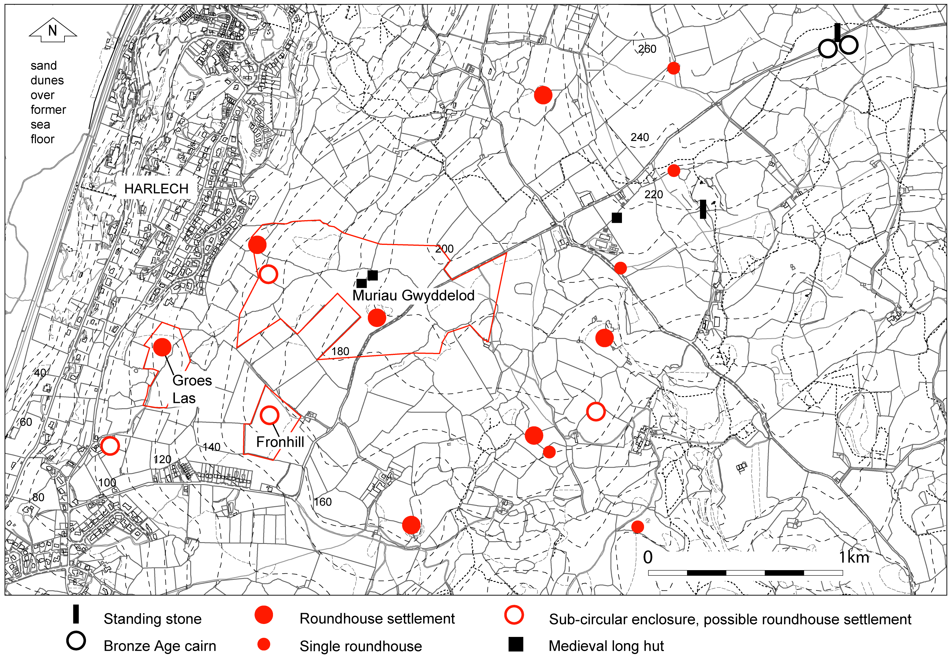
(10) Groes Las settlement (just west of and outside the survey area). This is a heavily overgrown site. It is a single large roundhouse, about 15m overall diameter, set within a roughly concentric sub-circular enclosure about 60m diameter.
(11) Fronhill probable settlement. A sub-circular stone-banked enclosure about 35m in overall diameter with a clear entrance but no visible internal buildings. Four early field banks join onto the enclosure wall. The early field banks in this area were more substantial than most of those elsewhere and this seems to be one of the best-preserved fragments of field system, as well as being associated with a possible settlement, so was chosen for more detailed study. A geophysical survey was carried out and a trial trench was excavated through one of the boundaries.
Although covering a larger area than the two previous studies, the field system here is fragmented and difficult to interpret, especially when the likelihood of medieval modification is taken into account. The most extensive area of survival is around the Muriau Gwyddelod settlement but this has survived because, with very thin stony soils, it has least agricultural potential and had not been subject to any medieval or modern re-use or modification. The presence of several areas of settlement suggests that each will have been surrounded by a cluster of cultivated 'infields', with access to more open areas of communal grazing further away. There are also hints of longer, major boundaries that may have divided farm territories. There are few surviving complete early fields here but there is an obvious rectangularity about them, with rounded corners in some places, comparable with the many examples of Iron Age or Romano-British 'Celtic' fields surviving elsewhere in North Wales and Britain generally. Several boundaries radiate from the enclosure of Muriau Gwyddelod, resulting in fields of irregular shape, some long and narrow, some curvilinear and partly concentric to the central enclosure. There are also a number of clearance cairns, some quite large. The relict road 'Y Ffordd Wyddelig' may have originated as a drove way connecting with a double-walled 'lane' leading from the Muriau Gwyddelod enclosure towards this old road. It must be borne in mind that this area of fields is set within an area where there are several other early settlements (Figure 14). The nearest open area of upland grazing lies about 2km away to the east. The overall interpretation of the settlement will be discussed later along with the information from the excavation and environmental studies.
Internet Archaeology is an open access journal based in the Department of Archaeology, University of York. Except where otherwise noted, content from this work may be used under the terms of the Creative Commons Attribution 3.0 (CC BY) Unported licence, which permits unrestricted use, distribution, and reproduction in any medium, provided that attribution to the author(s), the title of the work, the Internet Archaeology journal and the relevant URL/DOI are given.
Terms and Conditions | Legal Statements | Privacy Policy | Cookies Policy | Citing Internet Archaeology
Internet Archaeology content is preserved for the long term with the Archaeology Data Service. Help sustain and support open access publication by donating to our Open Access Archaeology Fund.