Archaeological excavation was in its infancy in the 19th century, when antiquarian endeavour tended to be drawn less towards places of former settlement than to those of burial, with their perceived promise of rich pickings. As it happens, this has probably been to the benefit of hillforts, because such intrusions as were made in the name of archaeology before the start of the 20th century (and many made well into it) will often have done more harm than good, most yielding little that can now be viewed as reliable evidence. It is inescapable that much antiquarian effort has left us with tantalising hints, frequently through the biased medium of artefacts, even in Wales, where finds of material relevant to the perceived age of the hillforts are often notoriously few from the hillforts themselves. Forever deprived of an archaeological context beyond their mere presence on a given site (at best, in a specified part of the site), most of those 19th-century finds were no more capable then than now of providing sensible, rather than potentially deceptive, information, though a good deal has sometimes been built upon such shaky foundations.
A classic case is seen in the 1849 campaign of 'diggings' orchestrated by Ffoulkes on three of the six fine hillforts in the Clwydian Range of north-east Wales (1850).1 At Moel Fenlli, for example, Ffoulkes showed he could make rudimentary stratigraphical observations, allowing him to distinguish the secondary status of an entrance and to appreciate that his claim to have found a sherd of 'white pottery', presumed Roman, 'just under the rampart' was 'a fact somewhat material in determining the age' of the hillfort (Ffoulkes 1850, 84-5).2 Despite demonstrating some practical concern for conservation — as in stopping short of making 'a complete breach' through the rampart of neighbouring Moel y Gaer (the one nowadays suffixed Llanbedr), since he felt this 'would only be an useless disfigurement' and, anyway, he regarded his 'rough sketch' of a partial 'incision' as 'sufficient to show the nature of the construction' (Ffoulkes 1850, 177; Figure 1) — Ffoulkes felt no compunction in 'cutting trenches wherever the ground appeared inviting' (1850, 84) and, without recording their whereabouts, unearthing numerous sherds of 'Roman pottery' as well as items of metal and glass to add to earlier finds of Roman material from Moel Fenlli. He considered that his 'archaeological research' had succeeded in 'throwing some light upon the history of this ancient stronghold' (1850, 86), but the significance of his discoveries at Moel Fenlli (as at Moel y Gaer and Moel Arthur) remains obscure to this day, and will doubtless continue to do so until far more disciplined excavations are undertaken there on a very much greater scale.3
All that said, it may seem improper to belittle such faltering steps towards archaeological method, because, as the knowing Ffoulkes put it, 'we all waddle before we walk' (1850, 185) — in other words, for those who have not had to confront the equivalent of navigating in a foreign land without a map (which means everybody reading these words, at least in regard to Welsh hillforts), it would be all too easy to castigate such pioneers for their heavy-handedness and naive views. Besides, even such low-grade scraps of excavated data can retain some value locally, if only as vague pointers to chronological potential, but only if utilised with great caution. Also on the credit side, Ffoulkes's fieldwork did provide us with the first useful plans of these three 'Clwydian camps', being some of the earliest (but far from the earliest) made of any hillfort in Wales (Figure 2). In employing dense hachures for earthworks alongside pseudo-contoured hill-shading of the enclosed area (and thus going some small way towards recognising a continuing need addressed below), those plans convey as good an impression of fortifications and site (albeit only the interior) as do most published in Britain up to then, and they are just as much children of their time as are his dubious diggings.
Although some practitioners continued to perpetrate equally coarse excavations beyond the turn of the 20th century (even among the Clwydian hillforts, as witness the needless wounds inflicted upon Moel y Gaer, Bodfari, by Stapleton in his 1908 excavations (1909)), 'exploration' that was arguably somewhat more methodical had already been seen in Wales by then, notably at the hands of Baring-Gould and colleagues, applying their experiences in Devon and Cornwall to tackling three forts in south-west Wales and one in the north-west.4 These provide examples of what is to be expected of excavations that were clearly regarded as thorough and respectable by contemporaries, but which, to lengthen Ffoulkes's apt metaphor, were still shambling along. In 1898, at St David's Head, six 'hut circles' were gutted, 'proceeding by sections' and digging deep to remove soil for 'sifting', noting the presence of charcoal and 'fireplaces', claiming to identify 'floors' but without defining them, and, though aware of a need to notice structural particulars of the walling, depicting precious little of any structure in a plan said to render 'detail' (Figure 3; Baring-Gould et al. 1899).5 In truth, it was the quest for artefacts that sustained these early excavators in their labours, and the sizeable return (for Wales anyway) of Iron-Age and Romano-British objects led to the 'workmen' being congratulated for becoming 'so expert that nothing escaped them' (1899, 107). Those in charge seem to have been immune to, or ignorant of, the wholesale damage wrought upon structural and stratigraphical elements of the site by their activities; and, given that practically all archaeological potential of the 'huts' seems likely to have been erased, there is an irony in their suggestion that the results were to be regarded as 'promising' (1899, 120). They transferred attention to Moel Trigarn in 1899 (Baring-Gould et al. 1900), and this hillfort was perhaps more challenging in certain respects, with an absence of 'hut circles' leading to recognition, but not mapping, of an array of platforms recessed into otherwise sloping ground within and around the 'fortress', and a commendable realisation that these might have been created to hold 'habitations of some perishable material' (Baring-Gould et al. 1899, 194; much as the astute Ffoulkes had spotted, but again not recorded, platforms inside Moel Fenlli, fully half a century earlier). Alas, the standard of investigation of numerous of these 'hut-sites', seemingly by rummaging through all deposits to some depth, once more principally in search of artefacts, offered no prospect that any evidence of such structures might actually have been identified rather than merely imagined, nor much hope that any part of them could have survived as an inducement to later excavators. At both of these hillforts, trenches (inadequately located by planning, just like many other early excavations) were dug through the entrances, 'from end to end' and apparently without reference to their structure, but these were afforded scant notice because they 'gave no result', a phrase that can be presumed to mean no finds, so reinforcing an overall impression that the excavators felt an overriding concern with establishing that these forts were 'occupied during the Iron Age' (Baring-Gould et al. 1899, 124-5; 1900, 207-9). In itself, this may seem a perfectly understandable goal for those early days of hillfort studies, but it should not be supposed that the inception of either fort, nor even any episode of construction, could be properly pinned down in this manner.6 In 1903, they moved north to Tre'r Ceiri, there continuing in much the same fashion, with dozens of 'huts' scoured 'right down to the subsoil', expressly 'in order to ascertain its date' (Baring-Gould and Burnard 1904, 1, 4). This exercise yielded artefacts and elicited observations on the 'rudeness' of the walls, together inferred to be adequate demonstration of 'erection of the fortress at an early period of the first century' (1904, 14-15) — of course, it would be misguided to believe that they achieved any such thing, and the real age of the dramatic walls of Tre'r Ceiri still remains unproven.
It is striking that the fieldwork headed by Baring-Gould paid cursory attention to the defensive, or anyway enclosing, circuits of the hillforts investigated, and this is equally true of some who came in his wake, since a need for dating evidence remained dominant in shaping attitudes among most hillfort excavators, to whom it will have seemed obvious that this might best be satisfied by searching what appeared to be the most likely areas of occupation within the ramparts. In north-west Wales, the mantle was taken up by Hughes, who assumed control over the Tre'r Ceiri rout of 'huts' in 1906, having participated in the work of 1903, which had clearly contributed to his subsequent expeditious habits (64 huts 'examined' in 22 days with an average of seven 'labourers' is the combined total for 1903 and 1906 at Tre'r Ceiri — Baring-Gould and Burnard 1904; Hughes 1907). Driven more by enthusiasm than discipline, at least in his 'diggings', Hughes had behaved similarly at Pen y Gaer, Llanbedr y Cennin, in 1905, and he proceeded to do so again, and with greater persistence, at Braich y Dinas in 1911-22, clearing numerous 'platforms' and 'huts' in the hunt for artefacts, particularly at the latter site, whose 'lofty, impregnable' summit required an early, and laudable, rescue operation due to its 'impending doom' in a quarry (Braich y Dinas — showing that some tentative deductions can be drawn from distributions of artefacts even at such a low level of record). Hughes seems to have taken relatively little interest in the enceinte of these hillforts beyond mapping them (in itself a valuable achievement for the now-destroyed Braich y Dinas — 1923, fig. 1) 7 whereas contemporary 'spade exploration' in north-east Wales bucked the trend by focusing predominantly upon the ramparts, ditches and gateways, as overseen by Gardner, first and belatedly at Pen y Corddyn, in 1905-9 (Gardner 1910), and thereafter at the great promontory fort of Dinorben, in 1912-22 (Gardner and Savory 1964, and numerous earlier reports listed therein, several of which are cited below).
Gardner's work at Dinorben drew fine praise from his peers, believing it to be 'as scientific a piece of excavation as any yet attempted in Wales' (CAA 1919, 594), and esteem is still avowed by some (e.g. Hogg 1975a, 25, 189; Brown 2009, 16). Yet it is manifest that there was little archaeological subtlety in the execution of most of his excavations, nor therefore in the dependability of the results. Gardner's reports make it plain that he had a good grasp of stratigraphy, but, to a significant degree, this ability was confounded by the regular practice, there as elsewhere by others, of hiring labourers of no special archaeological discernment or sympathies to undertake much of the actual work in the field; and it seems this was sometimes allowed to proceed without tight supervision. In fact, Gardner's words do divulge some discomfort over this very matter, at least at Pen y Corddyn, where he found it 'better in many ways to entrust the digging to a single workman' (Gardner 1910, 80), though the photographs in that report betray how rough was much of the workmanship. But such qualms were evidently soon overcome, for he was to employ up to ten men, besides volunteers, for many weeks at Dinorben. It seems probable that only the more solid features would usually be identified through their 'attack with the spade', generally directed at 'driving' narrow trenches into the earthworks (of the sort that were to become common currency with hillfort excavators over the decades ahead — see below), but sometimes clearing patches of ground inside the hillfort, principally in seeking out 'relics … by careful riddling' (e.g. Gardner 1915, 204-5). There seems little likelihood that tenuous elements of a rampart's construction, notably subtle signs of timberwork, would have entered the repertoire, nor even the consciousness, let alone the record, of most of those engaged in these pursuits (despite 10). To twist a poignant cliché, the devil in such crude excavations lies in the lack of detail.
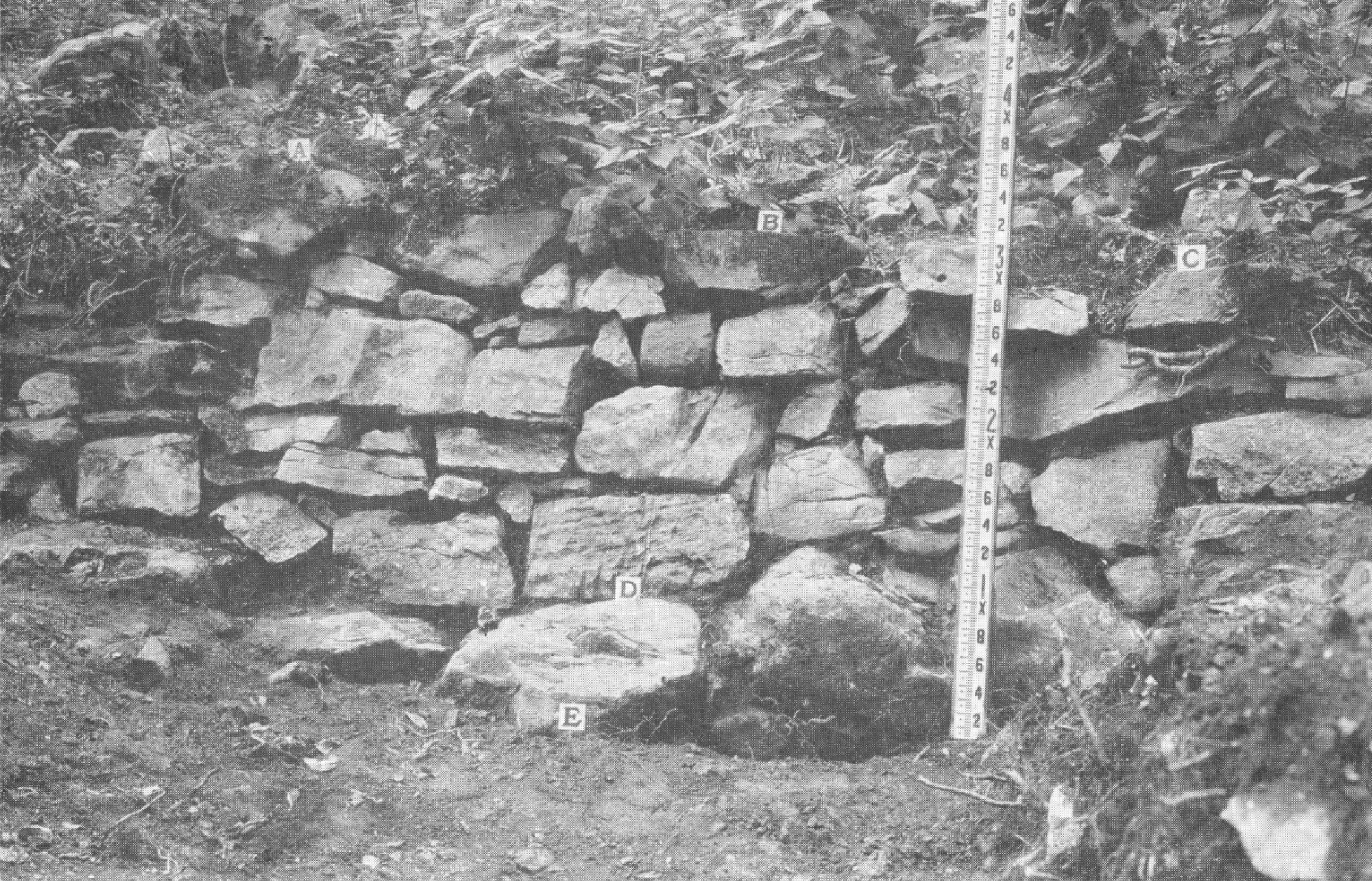
Walling buried within the make-up of banks became a particular target, and sometimes such stone revetments might be chased out along the face of a bank, clearing away apparent debris in a least-effort procedure for revealing their continuity and character. This could be made to look impressive (Figure 4 — a modest example in a clear photograph), and some so-called 'excavators' in those early days seem to have done little else (e.g. Prichard 1887, baring facings for up to c.18.2m at a stretch at Caer Drewyn). Doubtless it was then seen as sound strategy, but retrospectively it must be regarded as reprehensible. If such a judgement appears harsh, then reflect that such a practice is liable to lead to partial collapse of unexcavated portions of the wall/bank, especially where the facing was left exposed to view, which seems often to have been so (as at Dinorben, where it was done more extensively than Gardner's records seem to show). In addition, it can effectively divorce a rampart from any deposits that may formerly have been stratigraphically inter-related with it. In other words, such 'archaeological' activities can impair the integrity of the monument, inevitably reducing the prospects for subsequent excavators to apply improved methodology to those same stretches of earthwork — and it is not good enough to retort, as is frequently done, that most hillforts have plenty more rampart for others to explore at a later stage, for who can predict which stretches of a given circuit may eventually, for some reason or other, come to seem most vital to comprehending the fort under consideration?
Internet Archaeology is an open access journal based in the Department of Archaeology, University of York. Except where otherwise noted, content from this work may be used under the terms of the Creative Commons Attribution 3.0 (CC BY) Unported licence, which permits unrestricted use, distribution, and reproduction in any medium, provided that attribution to the author(s), the title of the work, the Internet Archaeology journal and the relevant URL/DOI are given.
Terms and Conditions | Legal Statements | Privacy Policy | Cookies Policy | Citing Internet Archaeology
Internet Archaeology content is preserved for the long term with the Archaeology Data Service. Help sustain and support open access publication by donating to our Open Access Archaeology Fund.