Cite this as: Murphy, K. 2018 The Atlantic Coast, Internet Archaeology 48. https://doi.org/10.11141/ia.48.5
The Atlantic zone is a convenient concept in Iron Age studies, as settlement from northern Scotland to north-west Spain displays two strongly unifying themes that define it and, to a lesser degree, separate it from events elsewhere: namely the large numbers of small defended settlements and the general absence of archaeologically recoverable material culture (Cunliffe 1991, 2004). However, it would be wrong to suggest that the parallels between different regions of the Atlantic zone are a strong indication of cultural contact between these areas, as the differences are often more striking than the similarities. The occurrence, therefore, of small, defended settlements may be a common response to outside or other stimuli.
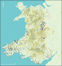
Hillforts, promontory forts and smaller enclosed sites are the most visible settlement type in Iron Age Europe. The settlements along the Atlantic coast of Europe, although viewed by many as peripheral to what was happening deeper within the continent, fall within what for convenience can be called this defensive tradition. There are regional differences along the coast, and some settlements have developed unique characteristics, but there are many unifying factors. It is intended here to explore briefly these differences and similarities, with an emphasis on recent work from the Atlantic zone of Wales. This article first presents a very brief review of the available evidence for Iron Age settlement along parts of the Atlantic coast of Europe - Wales, south-west England, Brittany, western Scotland, western Ireland and north-west Iberia. Short sections on the settlement types in this zone follow: hillforts, promontory forts and, finally, small defended farmsteads and villages. Some concluding remarks are then presented.
The concept of prehistoric and historic cultural connections along the west coast of Europe is not a new one. Archaeologists explored it in the first two decades of the 20th century, but it then fell out of favour until the 1970s when E.G. Bowen briefly revived the notion (1972, 1977). Barry Cunliffe's comprehensive survey (2004) and other research on genetics, language and literature (Cunliffe and Koch 2012) has breathed new life into the subject. Earlier writers tended to focus on geographical analysis of site types and artefacts, such as the distribution of Neolithic megalithic monuments along the west coast (Fox 1959), in order to demonstrate cultural contact from earlier prehistoric periods to recent times. More in-depth recent research has shown that contact between the various communities living on the Atlantic coast, and beyond, was maintained throughout the Neolithic and Bronze Age, but seems to have weakened during the first centuries of the first millennium BC (Cunliffe and de Jersey 1997, Henderson 2007). Lack of evidence is a problem during this later period, but a decline of bronze hoard deposition on the Atlantic coast c. 700 BC-600 BC indicates a slackening of ties between different areas of the coastal zone and between other areas of Europe. The Bronze Age/Iron Age transition, generally accepted at around 800-750 BC across Europe, is not a particularly useful concept for the Atlantic coast. No new technology replaces bronze in this period, and it is not until the last few centuries of the first millennium BC that iron is widely used in Wales, although it was around from about the 8th century BC. A more useful indicator of cultural change in this period is the emergence of small settlements defended by earth banks and ditches or by stone walls, which become the main settlement type across the Atlantic zone, and for much of Wales they represent the main, and it could be argued the only, body of evidence for human activity in the first millennium BC.
For several centuries at the beginning of the first millennium BC across much of the Atlantic seaboard paucity of evidence, not just of settlements, but also of almost all forms of human presence, presents enormous problems of interpretation (see several papers in Haselgrove and Moore 2007 and Haselgrove and Pope 2007). This is particularly a problem in Wales, where virtually all evidence is lacking. This lack of evidence may indicate very low levels of population, having fallen from an earlier high point. Certainly large numbers of Early Bronze Age burial mounds and other funerary and ritual monuments are an indication of a well-populated landscape during the second millennium BC. No new funerary and ritual monuments are constructed during the Middle Bronze Age and existing ones ceased to be used, and it is not until the beginning of hillfort construction that we can once again start to place people in the landscape. However, lack of evidence does not automatically translate to a lack of activity - there could have been a sizeable population in Wales in the first millennium BC that is not archaeologically detectable.
The paucity of Iron Age artefacts in the Atlantic zone seriously hampers Iron Age studies. Burials are also rare, and entirely absent in some areas. In Atlantic Wales, pottery, that most useful and durable of cultural material, is virtually absent from the end of the Early Bronze Age, when the tradition of burying the dead with urns came to an end in c. 1300 BC, to the coming of the Anglo-Normans in c. AD 1100. Other types of artefact, such as beads, brooches and iron objects tend to appear only towards the end of the period, and even then they are not common. An exception is during the Roman period, when imported pottery, beads and bronze objects are brought in with the military conquest. A similar absence of artefacts also plagues the study of Iron Age settlements in Atlantic western Ireland, in contrast to the central and eastern side of the country where high-status metalwork is commonly found, and also in western and north-western Scotland. The situation is a little better in south-west England where there is a recognisable ceramic tradition, such as South-Western Decorated Wares, which are available to assist in establishing chronology and formulating economic and social models. Indeed, over 4000 sherds of pottery were found during the excavations at Trevelgue Head promontory fort, near Newquay, Cornwall (Quinnell 2004), a wealth of finds barely imaginable to fieldworkers in Atlantic Wales. Further south, Brittany has a distinct Iron Age material culture, including pottery and metalwork, and uniquely carved standing stones or stelae (Cunliffe and de Jersey 1997). The Iron Age stones of Brittany are carved and either tall (sometimes fluted) or squat and occasionally carved with decorations. They follow in the long tradition from the Neolithic and Bronze Age of erecting stones, a tradition also common across western Britain and Ireland, but not, apart from some striking examples such as the Turoe stone in County Galway, continued into the Iron Age in these areas. Earlier prehistoric stones were the foci of religious and ritual ceremonies and the Brittany stelae may have had a similar function, or marked burials or boundaries.
Artefacts from north-west France provide one of the few pieces of archaeological evidence for direct cross-sea contact in the Iron Age. The context for this contact may well have been the tin trade between south-west England and the Mediterranean world, described in several classical texts. The tribes of north-west France may have acted as traders, as Caesar describes the Veneti as having 'a great many ships and regularly sail to and from Britain'. There is little artefactual evidence for this contact, apart from some similarities between brooches and other metalwork found in Brittany and in Devon and Cornwall, until the 1st century BC when pottery and coins from north-west France are found in southern England. The main trade routes into England were through Hengistbury Head and Poole Harbour in Dorset, Mount Batten in Devon, and the Solent, with the majority of artefacts traded on to locations in Wessex rather than tin-producing areas of the south-west (Wilkes 2004).
One area along the Atlantic seaboard where there is a rich material culture, particularly in the later prehistoric and Roman periods, is north-west Iberia (Parcero Oubiña and Cobas Fernández 2004). This can partly be explained by a long tradition of indirect contact with the Mediterranean world, and direct contact from the 1st century BC. However, it would seem that a distinctive and vibrant culture developed independently, evidenced by high-quality metalwork, sculpture - carvings of what are considered to be bulls and statues of warriors - and stone-built structures, sometimes underground, interpreted as saunas.
Fogous, souterrains or caves are other types of subterranean structure found in some coastal areas, but with no examples in Wales. Fogous, underground passages or chambers found in association with settlements, are a feature of Iron Age west Cornwall and are thought to date to the later Iron Age and carry on in use until the 4th century AD (Quinnell 1986). Similar sites, known as souterrains, are found in Brittany. These underground passages are often cited as evidence for close cultural contact between the two areas. Souterrains are also found in western Ireland, where they are frequently referred to as caves, and are associated with settlements and early ecclesiastical sites and date to AD 500 to AD 1200. Their function is the subject of debate, but they are likely to have been used for food storage, as places of refuge, for shelter during inclement weather, or even for burial. These functions do not have to be mutually exclusive.
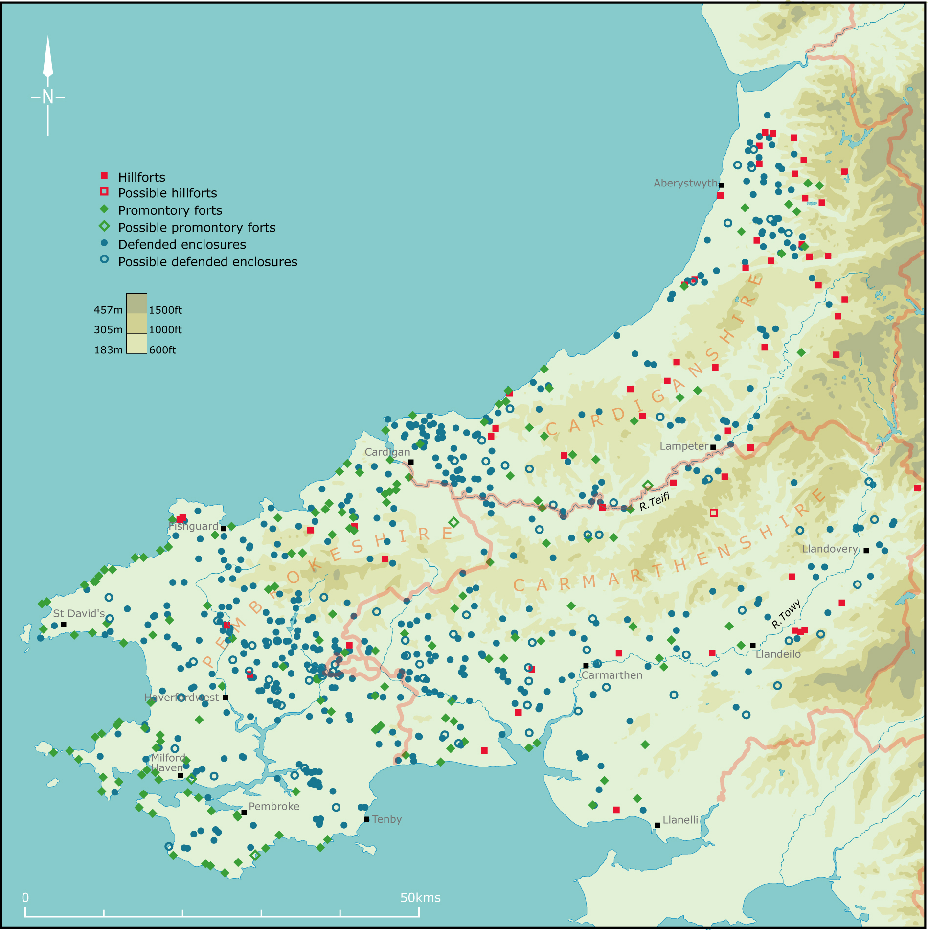
In Wales, in common with most of Europe, the first large defended enclosures — commonly known as hillforts begin to appear in the landscape at the start of the first millennium BC. Hillforts in the Atlantic zone are not large. Similar sites in the Welsh Marches and southern England are much larger, and the massive oppida of England and continental Europe dwarf them. An internal area of between one to three hectares is the norm for Atlantic zone hillforts and promontory forts (Murphy and Murphy 2010). The internal area of small, defended enclosures/enclosed settlements, enclosed hut groups, and the brochs and duns of Scotland is very small, on average around the 0.25–0.40 hectare mark, about 40m diameter (Henderson 2007).
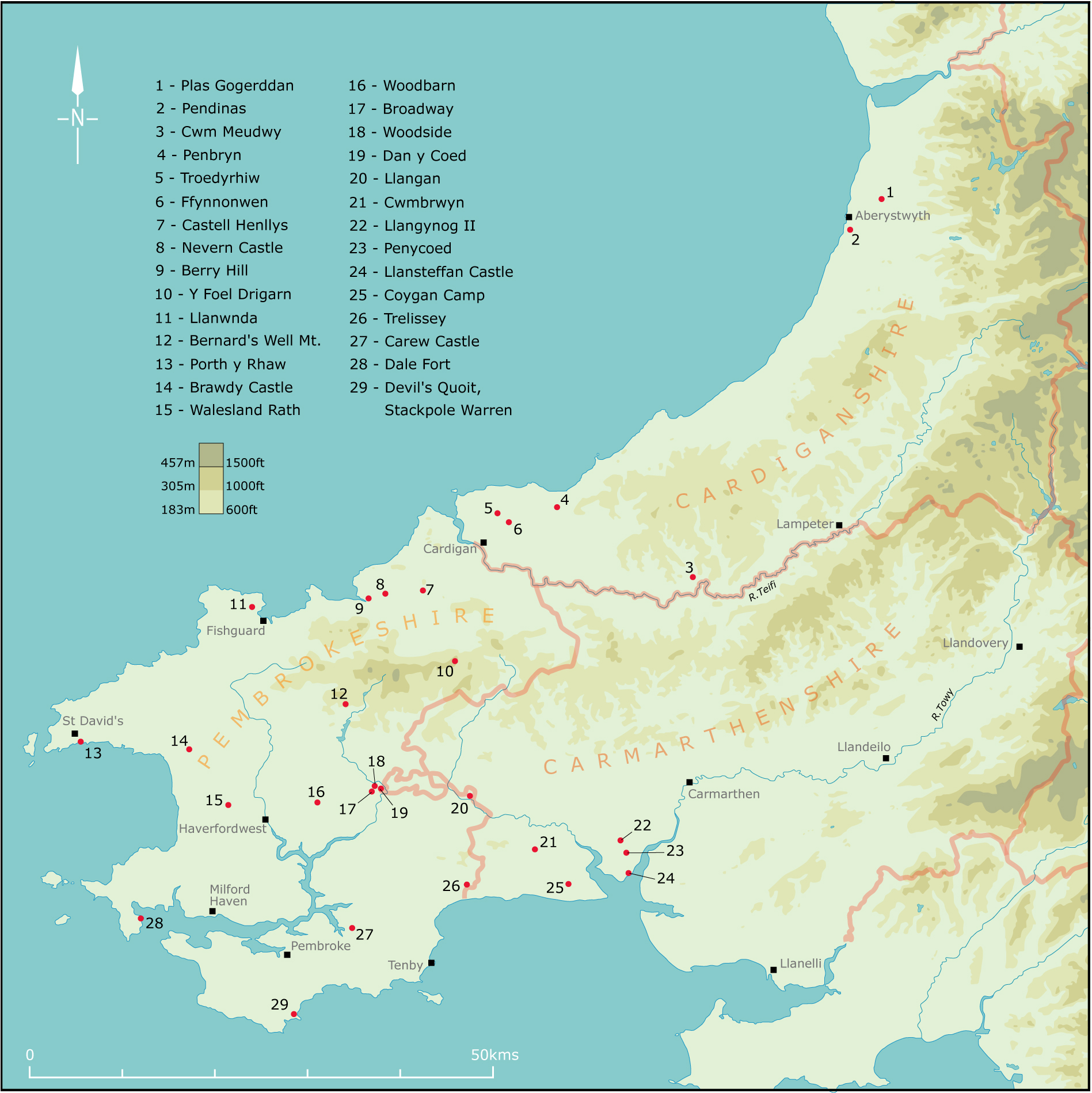
Evidence for early hillfort construction in Wales comes mostly from the east of the country, but there are data from the coastal west. Overall, hillforts are not the characteristic settlement of the coastal zone in Iron Age Wales, but in this early period they are the only settlement type (Figures 1-3). Two types of site are represented in this early hillfort period in the Atlantic West: hilltop enclosures and coastal promontory forts. Very few hilltop enclosures have been investigated, but those that have suggest construction around the middle of the first millennium. At Castell Odo, on the Llŷn peninsula in north Wales (Alcock 1960, a light stockade fence protected a small hilltop settlement. Working within the dominant theoretical framework of the late 1950s, the excavator assigned the construction of this settlement to invaders, perhaps in the 4th century BC. Radiocarbon dates were only just becoming available, and none were used at Castell Odo. Therefore sherds of crude pottery, for which few parallels exist, were the only dating evidence available. This original settlement was destroyed. A period of abandonment followed, after which the hilltop was fortified by a single bank. This was later strengthened with stone revetment walls and a second bank added. A settlement of stone-built roundhouses developed within these defences. In south Wales, excavation on the oval hilltop enclosure of Broadway at Llawhaden in Pembrokeshire (Williams and Mytum 1998) revealed that the site had been occupied immediately prior to the construction of a substantial ditch and bank defence between 700 BC and 400 BC. However, the discovery of a Bronze Age chisel incorporated within the bank may be evidence of much longer occupation on this rounded hilltop. There seems little doubt that other hilltop enclosures along the Atlantic coast of Wales, including those now occupied by major hillforts such as Y Foel Drigarn (Figure 7) in Pembrokeshire, Pendinas on the edge of Aberystwyth, and Tre'r Ceiri on the Llŷn were established in this period, although there are as yet no excavation data to support this suggestion.

The defences of many of these early hillforts are later enlarged and elaborated, as at Castell Odo, and new sites begin to appear in the landscape. The provision of several lines of defence, and new defensive systems such as chevaux-de-frise, also become features of sites in the 5th to 2nd centuries BC. Evidence from excavations across Britain indicates that during the 2nd and 1st centuries BC there was less intensive use of some of the larger hillforts and even abandonment of some. This coincides along most of the Atlantic coast with the rise of smaller defended settlements - defended hamlets and farmsteads - that are so characteristic of the Late Iron Age in this zone.
The date for the inception of hillfort construction in south-west England is the same as that for Wales. However, Iron Age defended settlement in Ireland, particularly in the west of the country, has been until recently little studied and poorly understood (Raftery 1972, 1976; Waddell 1998), and until recently very few sites have excavated. Recent surveys and excavations on hillforts mainly in the eastern, southern and central parts of the country by O'Brien and O'Driscoll (2017) have demonstrated that although morphologically they are generally similar to sites found in England, Wales and Scotland they were constructed, occupied and came to an end in the Bronze Age.
A very similar pattern of small hillfort development is documented in north-west Spain and north Portugal. These numerous and well-known sites, called castros, developed in the late Bronze Age through to the 5th century BC on prominent hilltops, and are the first large-scale settlements of this region (Ferreira do Silva 1995). They enclose an area of about 2 hectares and are normally defended by ditches and banks; occasionally by low stone walls. Many more castros were constructed over the following centuries. These later sites are located in less prominent, but nevertheless defensive, locations and are defended by massive stone walls, making them obvious elements of the landscape. However, in contrast to what happens elsewhere in the Atlantic zone, during the later Iron Age hillforts became larger, culminating, from the 2nd century BC, in oppida — these are large defended sites found across Europe and are often considered the first urban settlements. They are not, however, found in other parts of the Atlantic zone. In north-west Iberia hillforts achieved their most developed form in the 1st century AD, when they represent the only recognised indigenous settlement type.
Located on rocky coasts, promontory forts or cliff castles are widespread along the most exposed coasts of western Europe. They are found from northern Spain to the western Isles of Scotland. In Wales concentrations are located in Pembrokeshire, the end of the Llŷn, Anglesey, Gower and along the Glamorgan coast. In order to provide a defence, one or more lines of an earth or stone rampart are thrown up across the narrowest point of a promontory. High sea cliffs on other sides provide a natural and virtually impregnable barrier. This simple construction technique results in a remarkable similarity in form along several thousand miles of coast. Such are the similarities that given a photograph of a promontory fort it would be difficult to know whether it was from Brittany, Ireland, Wales or Scotland.
Coastal promontory forts were, until recently, considered to be a later Iron Age development, and, indeed, some early archaeological literature ascribes Welsh examples to even more recent invaders, such as the Vikings, while Cornish forts were considered to have been constructed by Breton immigrants fleeing the Roman invasion of Gaul. However, limited investigation on a few sites has demonstrated that they can be relatively early in date. For example at Dale Fort, on the Pembrokeshire coast, what on the surface appears to be a simple, single bank and ditch cutting off a long, narrow promontory was shown by excavation to have a very complex history. Unfortunately, the extensive excavations of the 1960s and 1970s have not been published, but radiocarbon dates place initial defence construction, including palisade trenches pre-dating the rampart, in the 9th or 8th centuries BC (Benson and Williams 1987). At Porth y Rhaw, also on the Pembrokeshire coast, initial construction of the massive and complex defences has been dated to between the 8th and 4th centuries BC (Crane and Murphy 2010) . Similar date ranges have been obtained from Cornish sites such as Trevelgue (Quinnell 2004) and The Rumps (Brooks 1974). Very little in the way of dating evidence has been obtained from Breton promontory forts, but we know of their use in the 1st century BC, as Julius Caesar describes how they were used as places of refuge during his military campaigns in the region (Wheeler and Richardson 1957). Morphologically the 200 or so Irish promontory forts are identical to examples in Wales, south-west England, Brittany and Scotland. However, radiocarbon dating from limited work on three sites indicates occupation almost one thousand years later, in the 6th to 11th centuries AD.
Coastal promontory forts possess several characteristics that are perceived as separating them from inland forts. For instance, many writers have questioned whether they were permanent settlements or whether they had a seasonal or other intermittent function. The exposed position of many forts has led to assertions that they could not possibly have been used during the winter months. Certainly a winter visit to a coastal fort can be an exhilarating experience, but the same could be said of some of the more exposed inland hillforts. Another problem to take into consideration would have been the safety of the inhabitants. If these were permanent settlements, then without constant vigilance and stout security fences several members of the community could well have been lost over the cliffs every year. A third consideration is the sheer size of the defences in comparison with the small internal area. While it is true that an unknown portion of many forts has been lost to the sea, well-preserved examples survive, some of which have massive banks and ditches, leading to suggestions that these sites had a symbolic role or religious function, located as they are on the boundary between the land and the sea.
Forts on the coast may have had a symbolic role, but evidence from the very few excavated examples points to them having functioned in a similar manner to inland forts. For instance at Porth y Rhaw, which has lost almost its entire internal area, eight roundhouses excavated in a narrow strip alongside the cliff edge are comparable with remains found on inland sites (Crane and Murphy 2010). Similarly, at Trevelgue Head in Cornwall (Quinnell 2004), a promontory protected by a remarkable nine lines of rampart (probably not all contemporary), evidence for metalworking and for a roundhouse was discovered, and several stone-built houses have been revealed within the castro built on a low rocky headland at Baròna in north-west Spain (Parcero Oubiña and Cobas Fernández 2004). A specialised economy may have been a feature of these sites, with the inhabitants controlling and using coastal and maritime resources as well as inland agricultural land. It is, however, clear that more investigation is required on these rapidly disappearing sites if we are to understand them.
Although, as described above, hillforts and promontory forts are found along the Atlantic seaboard in the later Iron Age they are not the main settlement type in several areas. For instance, in south-west Wales, Devon and Cornwall defended enclosures, probably better termed defended or enclosed farmsteads/villages, are the dominant settlement type. In north-west and north Scotland brochs and duns form the dominant settlement type in the 2nd century BC through to the first centuries AD (Henderson 2007). These small stone-built defended settlements were designed to accommodate family groups. Duns are concentrated along the west coast and comprise a stone-built wall enclosing the settlement, while brochs are more tower like, often rising to several metres in height, and are mainly distributed on the north and north-east coast, Orkney and Shetland. Both brochs and duns are often sited on good-quality land close to the sea enabling the inhabitants the opportunity to exploit a variety of environments, including pasture, arable, coastal and maritime. The material culture from these sites is very poor, in common with settlements elsewhere along the Atlantic coast, for example the enclosed hut groups of north-west Wales — discussed elsewhere in this issue. These hut groups are of a similar age to brochs and duns, but morphologically they are quite different, and if anything share similar characteristics with the courtyard houses of the extreme south-west of Cornwall. Unlike the small, defended enclosures of south-west Wales, the enclosed hut groups of the north-west of the country are often associated with contemporary field systems. Defended enclosures are not limited to Wales and south-west England, but are found in varying numbers along the Atlantic seaboard. A rectangular example, similar to those in south-west Wales, known as Rispain Camp, in southern Scotland, has been dated to 100 AD to 200 AD, and recent aerial photography in Brittany is revealing a pattern of small, defended enclosures across the peninsula, but these have not yet been researched in detail (Cunliffe and de Jersey 1997).
Problems with identifying Iron Age settlement in Ireland have already been touched on. Between 30,000 and 40,000 small defended enclosures, called ring-forts, have been recorded in Ireland (450 are known from the Dingle peninsula alone, in County Kerry; Cuppage 1986), which are strikingly similar to sites in Devon-Cornwall and Pembrokeshire. Many of the Irish sites contain the place-name element 'rath', a term also applied to some Pembrokeshire examples. In contrast to Wales and the south-west of England, most Irish examples are considered to have been constructed in the early medieval period. However, the simple chronological picture is likely to be found to be more complex, as a Bronze Age origin has been demonstrated for some of the western examples.
Settlements — including hillforts, defended enclosures and promontory forts - are so similar in south-west England and south-west Wales that these areas are often considered together. However, there is a greater range of settlement types in south-west England than in south-west Wales, with upland settlement, rarely found in south-west Wales, a feature of Devon and Cornwall (Cripps 2007). These stone-built upland settlements are traditionally regarded as having been abandoned in the mid-first millennium BC during a period of climate deterioration. Upland abandonment is seen as coinciding or even promoting the construction of hillforts located on the interface of upland grazing and lowland pasture and arable. These hillforts are regarded as the residences of local elites controlling the population residing in the smaller defended enclosures, known as rounds in Cornwall. Recent commentators have suggested that changing patterns of social and economic control led to a collapse of this system in the later Iron Age, with power transferred to new elites living in the rounds, and the hillforts used for community activities. Other recent writers have emphasised that this seemingly simple chronological model could mask complex local social and economic groups that may not have had strong hierarchies.
It is the rounds and the associated smaller, defended farmsteads and villages that characterise the settlement pattern of Devon and Cornwall. At least 750 such sites have been recorded in the two counties, and over the last 20–30 years aerial photography has provided evidence that a remarkably similar pattern of small, defended settlements exists across the rich, rolling farmland of south-west England to that found in the pastoral landscape of Pembrokeshire, Carmarthenshire and Ceredigion.
Excavation of rounds in Cornwall demonstrates a similar date range and function to sites in south-west Wales, with construction in the 4th to 1st centuries BC. However, there is a greater body of evidence for continuous occupation through the Roman period to about AD 600 (Quinnell 1986). Small-scale excavation on a relatively large number of smaller defended settlement sites in Devon has, however, produced a bewildering range of dates. This has challenged the assumption that defended settlements are all of Iron Age origin, and demonstrated that typology and morphology are not always indicators of date, or indeed of function. A Neolithic radiocarbon date has been obtained from a small enclosure at Sourton, and Bronze Age and early to mid-Iron Age ceramics found on three other sites. The use of sites becomes more visible during the Roman period largely owing to easily recognisable pottery and other finds, and it is not surprising that these types of finds have been identified in over ten enclosures. Other work has demonstrated medieval and even 16th century AD use and construction.
Although comparisons are being made here between the Atlantic seaboard of Wales and other maritime areas of Britain and further afield, aerial photography over the past 20-30 years has revealed numerous small, cropmark defended settlements across parts of Wales not previously considered to have large numbers of this type of site. For instance, in mid-Wales a number of these sites add to known settlements in a landscape dominated by large hillforts. In the coastal Llỹn peninsula, in north-west Wales, where few small, defended enclosures had been known, over a dozen such sites were discovered from the air during the dry summer of 2006. These discoveries are an indication that small, defended settlements may be characteristic of the late Iron Age even in areas considered to be dominated by large hillforts.

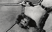
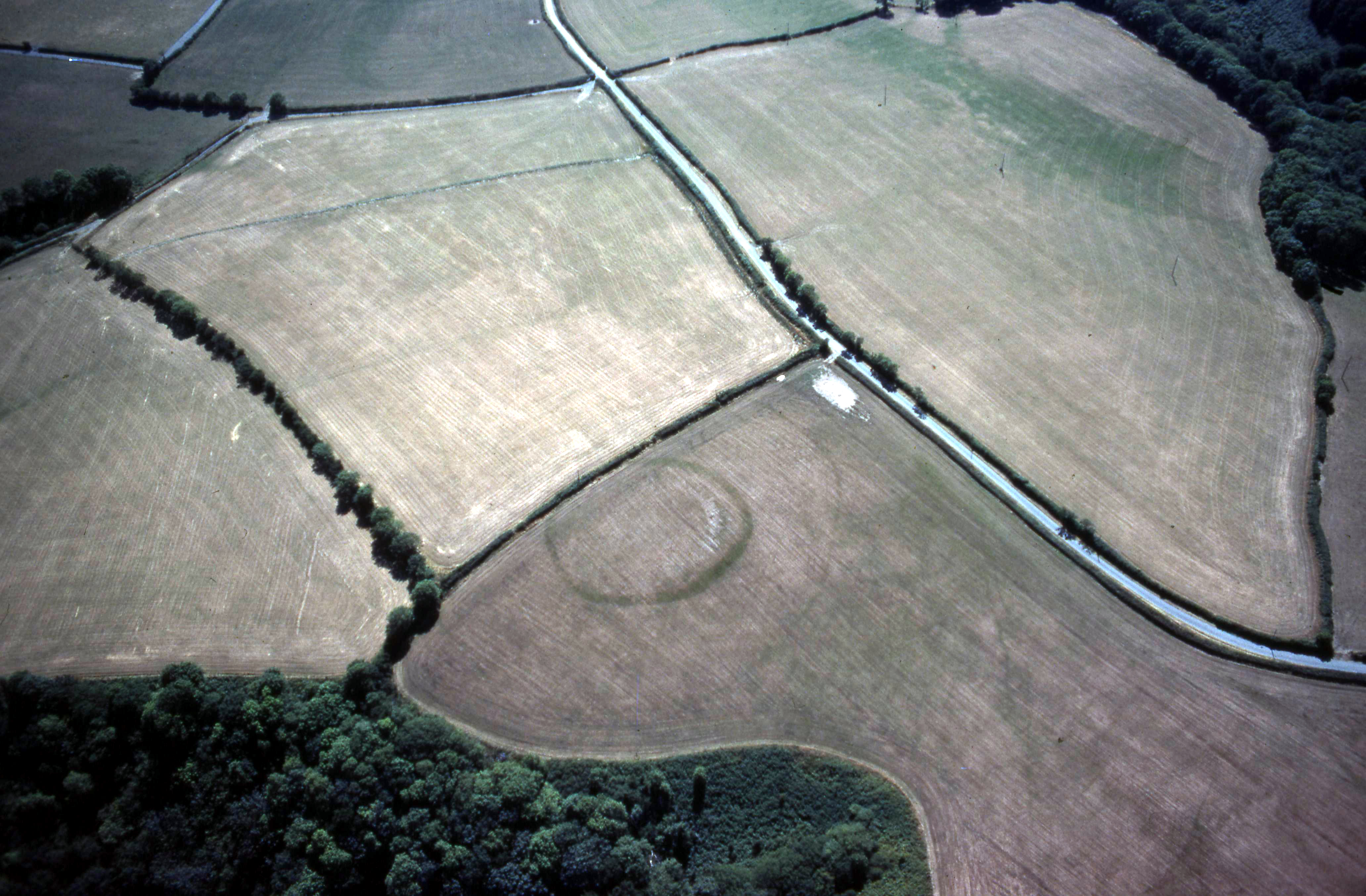
In Atlantic Wales, indeed across much of Wales, the impoverished character of the material cultural record means that a great reliance is placed on scientific dating methods. Overall the picture for Atlantic Wales is similar to that for south-west England, with the construction of defended settlements, sometimes called raths in Pembrokeshire, and smaller defended farmsteads in the later Iron Age. Information is limited, but, as in south-west England, the evidence from sites such as Castell Henllys (Mytum 2013) points to a decline in the importance of hillforts in the 3rd-2nd century BC at the same time as smaller sites are appearing more frequently in the landscape. The long chronological range obtained from sites in south-west England is not paralleled in those from south-west Wales, where a much shorter date range is indicated. For instance, the circular or sub-circular defended enclosures of Walesland Rath, Woodbarn Rath, Woodside and Dan-y-Coed (Figure 4), all in Pembrokeshire, had 2nd or 1st-century origins (Williams and Mytum 1998). The small rectangular defended farmstead at Penycoed, Carmarthenshire (Figure 6), was constructed in the 1st century BC-1st century AD (Murphy 1985), as the similar nearby enclosure of Llangynog II may also have been (Avent 1973, 1975).
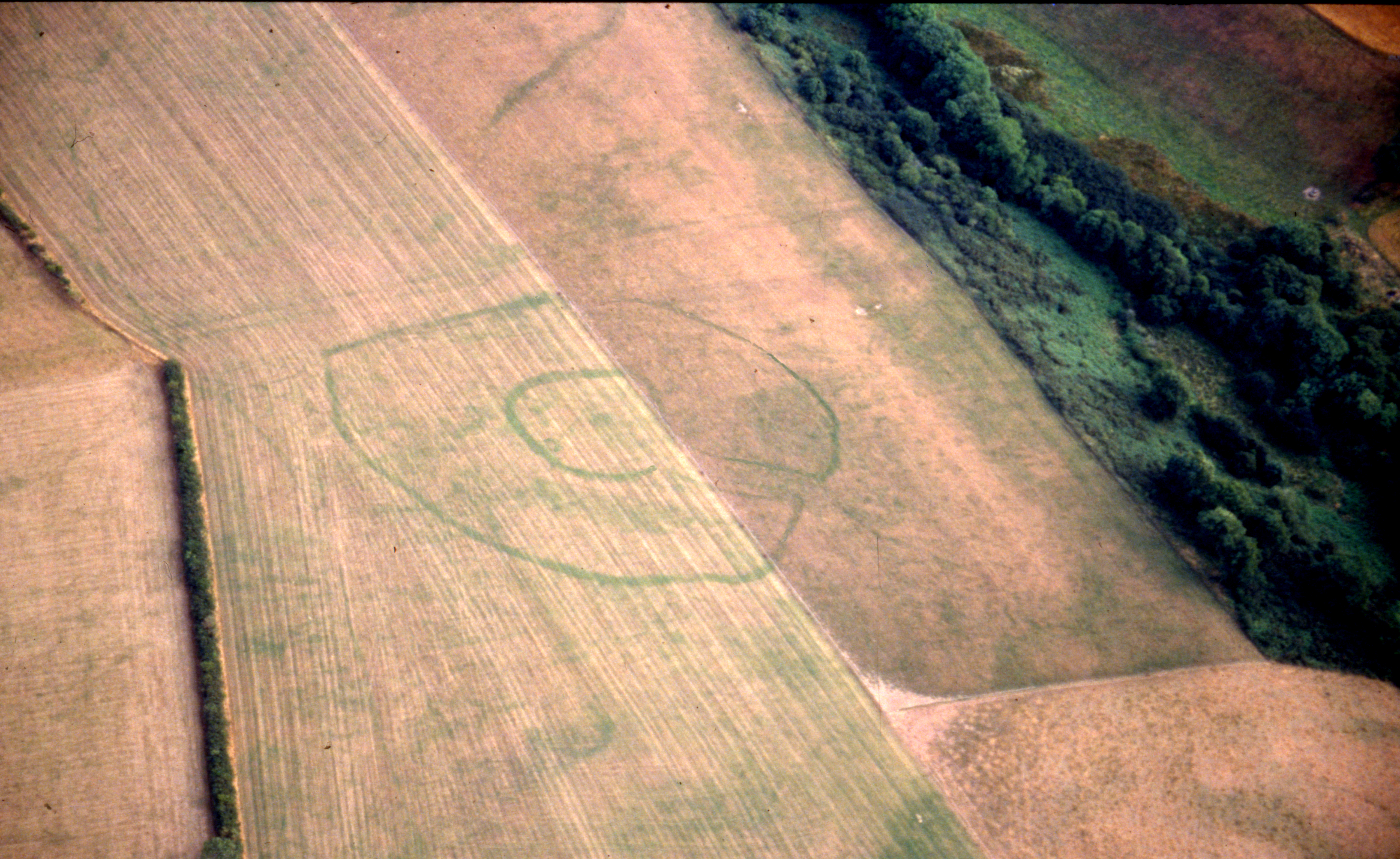
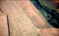
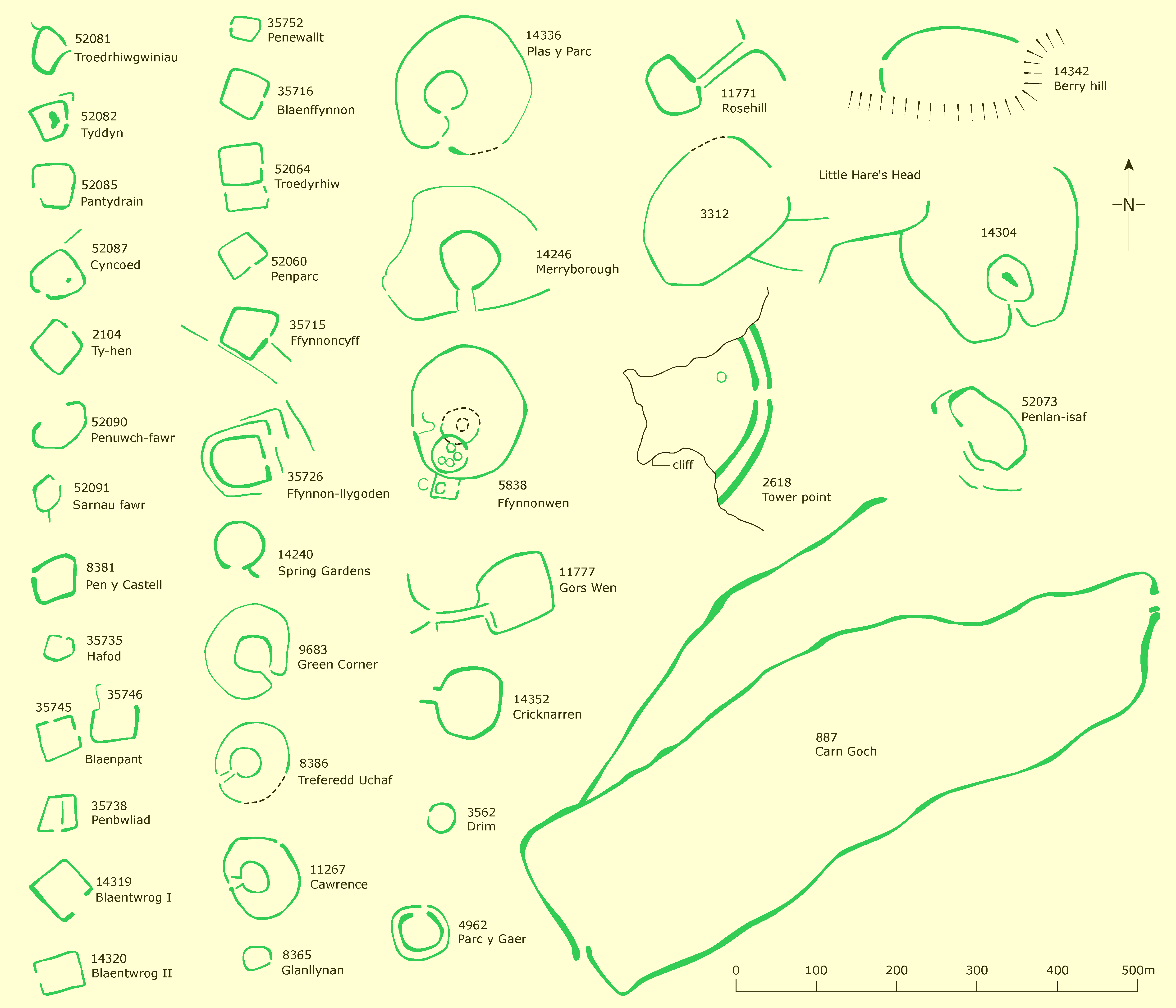
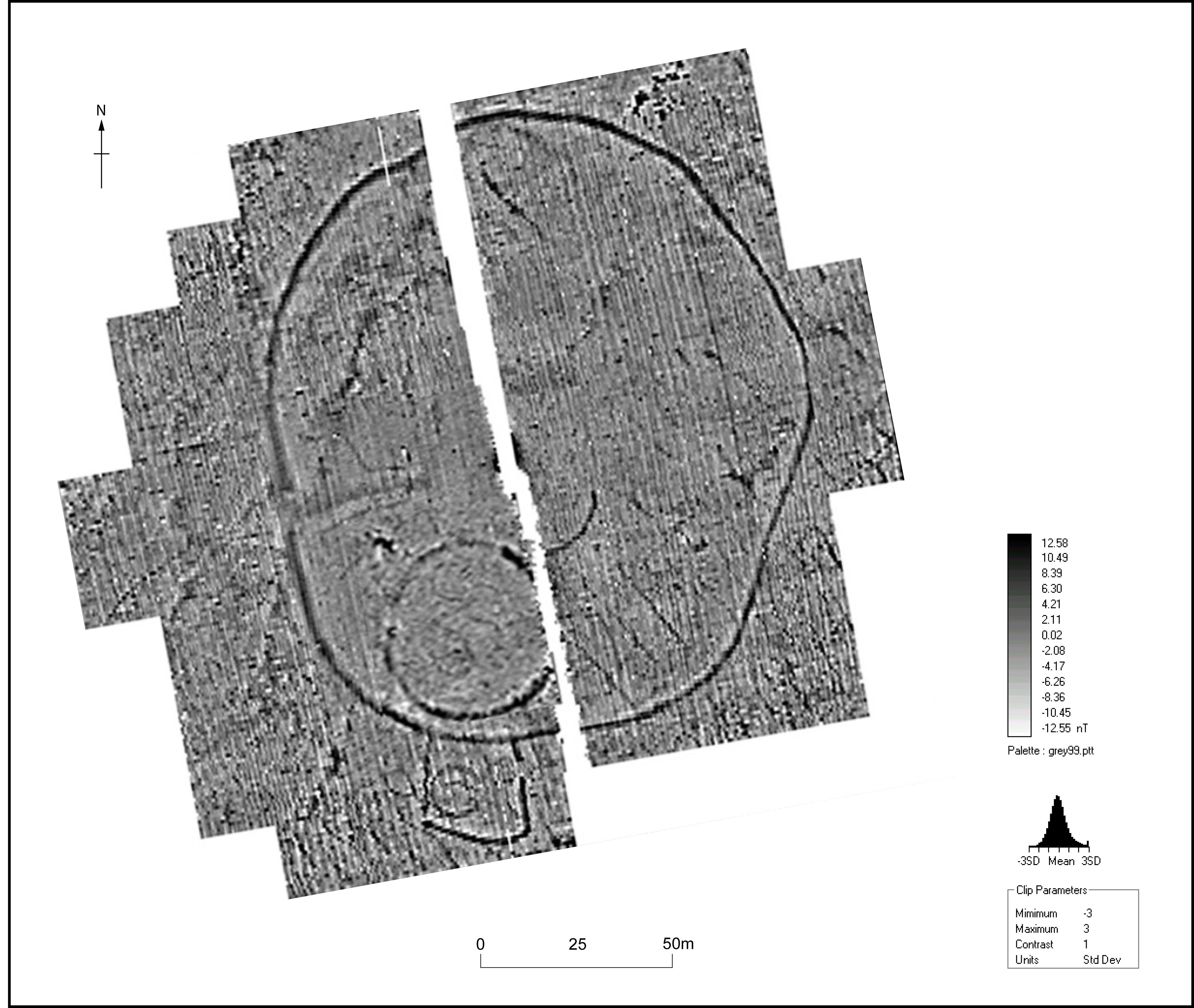
As noted earlier, the area enclosed by the defences of a small settlement is very small, and, in the smallest examples, may only be sufficient for a single roundhouse. Annexes can add considerably to the area enclosed within the defensive circuit. Annexes can take several forms, but there are two common types: those attached to hillforts or promontory forts where an additional defensive bank has been thrown up some distance from the main defensive circuit, and concentric annexes surrounding the often small internal area of a defended enclosure. The annexes of these latter sites are usually recorded as cropmarks, detected by aerial photography (Figures 5a and 5b). Often referred to as concentric annexes, or 'banjo' enclosures, on account of their shape, they have been identified elsewhere in southern Britain, as well as in Wales. Whereas the annexe defences on promontory forts and hillforts can be as substantial as those of the main defensive circuit, excavations on smaller defended enclosures has demonstrated that annexe defences can be quite insubstantial, with ditches often less than one metre deep (Murphy and Mytum 2011). This led to some 20th-century writers, using examples from sites in south-west England, to suggest that these sites were evidence of a pastoral economy where the inner enclosure was used exclusively for housing and other buildings and the annexe or outer enclosure reserved for livestock, in particular cattle. This theory has never been tested by excavation or geophysical survey. There are other possibilities. Annexes could have been used for raising crops with livestock pastured outside. Interestingly, excavation at Castell Henllys revealed Roman-period roundhouses and other buildings in the annexe but no evidence that the main defended area had been used at this time. The reasons for this are not clear; they may have been economic, social, political or ritual. In the latter case the Roman-period dwellers in the annexe may have been unwilling to live, or forbidden from living, in the same location as their ancestors, or someone else's ancestors. This use of concentric annexes raises all sorts of interesting questions, on which, owing to a lack of evidence, we can only speculate. Were they used for agriculture? Were they reserved exclusively for religion or ceremonies, such as exposure of corpses? Or perhaps they were buffer zones of vacant land serving to demarcate and define agriculture from settlement.
Smaller defended settlements occupy a wide variety of locations: rounded hilltops, sloping ground and valley floors, with the most favoured location being on a slope just off a high point. These are all non-defensive locations, and indeed many enclosures are overlooked from nearby higher ground. This is in contrast to larger sites such as hillforts, coastal promontory forts and inland promontory forts that tend towards locations that are naturally well defended such as hilltops, cliff edges or the edges of steep valley sides. Apart from on the coasts, these locations, by their very nature, tend to be at a relatively high elevation.
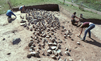
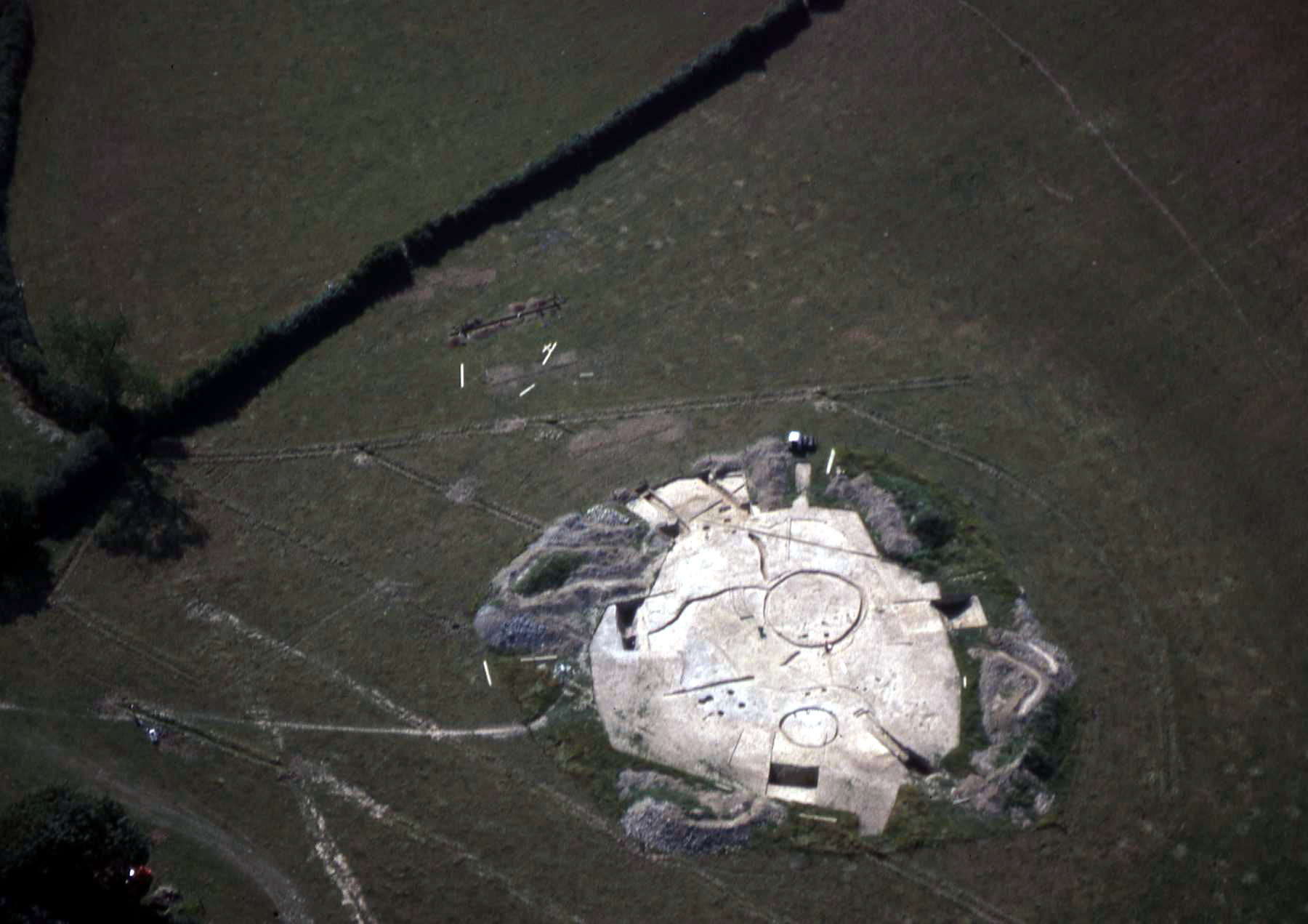
Large-scale excavation on a few defended settlements over the past 30-40 years has been very instructive. At Llawhaden in Pembrokeshire a group of a dozen or so enclosures lying in an area a little over one square kilometre were investigated in the 1980s (Williams and Mytum 1998). Two neighbouring sites, Woodside and Dan-y-Coed, were fully investigated. Both are similar sized, being about 40m in diameter, and enclosed by a substantial ditch and bank. Woodside enclosure was constructed in the 2nd-1st century BC, and continued in use into the early Roman period. Roundhouses and four-post structures, buildings typical of this period, were densely packed within the interior. Some degree of zoning is evident, with the four-posters being confined to the south-west corner and the roundhouses tucked in behind the defensive bank. Central hearths in some roundhouses strengthens the generally accepted interpretation that these were dwellings and that the four-posters were raised-floor buildings used as granaries or for the storage of other foodstuffs. Owing to the paucity of stratified deposits it was not possible to provide phase plans of how the interior of the site evolved over time, but the roundhouses had been rebuilt, some several times, in the same location, indicating that the interior was heavily used throughout the life of the settlement. A startling aspect of Woodside is the seemingly disproportionate size of the defences in relation to the relatively modest internal area. In addition to the bank and ditch surrounding the settlement, the entrance, a gate of four posts — possibly a tower, was approached by an 80m-long track flanked by massive ditches and banks. A second gate, again possibly a tower, lay partway along the track. During the life of the enclosure two additional lines of bank and ditch were built concentric to the defensive circuit blocking the approach track, and necessitating the remodelling of the entrance.
Greater clarity in the stratigraphic record at Dan-y-Coed allows the identification and characterisation of different periods of occupation. Overall the pattern is similar to Woodside, with the enclosure constructed in the 2nd-1st century BC and continuing in use into the Roman period, and possibly the post-Roman period. The interior was intensively used but, curiously, after an initial phase roundhouses were abandoned and four-posters become the only archaeologically identifiable interior structure, perhaps indicating that the site was used for storage and not occupied. As at Woodside the enclosure was approached by a track with flanking banks and ditches, but these were less massive with no evidence of remodelling.

Penycoed, Carmarthenshire, is at the lower end of the scale of small, defended enclosures. Located at the foot of a slope, this rectangular enclosure was discovered and excavated in the early 1980s (Murphy 1985) when it was seen as a slightly unusual site. Aerial photography has added greatly to our knowledge since then, and rectangular enclosures are now known to be more common. Penycoed is a simple farmstead constructed in the 1st century BC-AD, enclosed by a bank and ditch, and consisting of a single roundhouse and a four-post structure. A smaller roundhouse built over the reduced bank is of Roman date. Environmental evidence from waterlogged deposits in the ditch showed that the inhabitants relied on a mixed farming economy, with a strong pastoral element.
The settlement evidence from south-west Wales, and indeed from much of the Atlantic zone, suggests a landscape becoming increasingly heavily populated towards the end of the Iron Age, in the 1st centuries BC-AD, with the overall pattern from south-west Wales of settlements becoming smaller and more numerous as the Iron Age progresses. The population is unknown. However, it is worth noting that in south Ceredigion the number of known defended settlements is similar to that of current, large farms. In this area, the Iron Age population, therefore, may have been similar to the modern agricultural population. This is assuming that defended farms and hamlets were the only Iron Age settlement type and that open settlements were not present (these latter types are discussed below).
Open settlements - roundhouses and hut groups - are not well represented in the archaeological record for south-west Wales (in north-west Wales they are the dominant settlement form, as described elsewhere in this issue). Although in Devon and Cornwall stone-built settlements of this type are common on the uplands in the later Bronze Age and early Iron Age, in Wales they are not. The paucity of settlement evidence in the later Bronze Age has been touched on earlier. What is not currently known in Atlantic Wales is whether in the early to mid-Iron Age hillforts were the only settlement type, or whether lesser, subordinate settlements were also present. If we accept the notion that hillforts were for an elite, then the existence of other lesser settlements is implied. The south-west Wales archaeological record is not entirely blank, however. Stone-built roundhouses lie on Bernard's Well Mountain in Pembrokeshire and house circles with extensive field systems are found on Skomer Island, off the Pembrokeshire coast. Neither of these sites has been dated and, as John Evans (1990) said of the Skomer remains, they could date from the Neolithic to the coming of the Romans, a span of 4,000 years. More useful is evidence from excavations on Stackpole Warren, Pembrokeshire, where at two sites possible roundhouses, hearths and food debris were radiocarbon dated to the 2nd-3rd centuries BC continuing into the 3rd century AD (Benson et al. 1990). Accumulating wind-blown sand caused both the abandonment and preservation of these settlements. Outside of this specialised environment, problems of identification of open settlements are acute with reliance on chance discoveries during development. Such a discovery was at Cwm Meudwy, Llandysul in Ceredigion, where a palisaded enclosure may date to the Late Iron Age, although the dating of this site is problematical (Murphy and Evans 2006).
It is unclear whether the development of small, defended settlements along the Atlantic seaboard is an indication of close cultural contacts (and here paucity of artefacts is a real problem) or a common response to common environmental, economic, political and social stimuli. It is also unclear why the coastal communities decided to build and live in such settlements. It has been argued that the decline in hillforts in the 3rd–2nd centuries BC heralded a lessening of the power-controlling elites, resulting in a less hierarchical society, as evidenced physically in numerous small settlements of the first centuries BC–AD. The rise of small settlements as hillforts declined in this period may have been common across much of western Europe, but is occluded and overridden by the rise of oppida, centres of tribal power, perhaps in response to Roman political developments. Along the west coast the threat from these political developments was perceived as distant and therefore society continued to be organised less tribally and less hierarchically. Certainly the light Roman military presence in south-west Wales and south-west England is viewed as evidence of less warlike societies in these areas. However, the similarity of settlement types is possibly evidence that society was unified and well organised, but perhaps not hierarchical and warlike.
The impetus for hillfort construction is touched upon elsewhere in this issue. Some suggestions why small defended settlements were constructed are presented here. Several recent writers have pleaded that warfare should not be airbrushed out of the record, as has been the case over the past decade or so. While it is difficult to envisage how warfare can be accommodated in the pattern of numerous defended settlements, conflict is less of a problem. Conflict is more likely to have taken place between different kin groups than within a kin group or between near neighbours. In this respect it is instructive to refer to the Irish tower houses of the 16th and 17th century AD. Historical records show that members of a kin group constructed sets of these houses (and there are many thousands across Ireland) in order to affirm group identity, as intra-group competition and as assertions of territorial rights, creating cohesion in kin groups at a time of rising population. The distinctive defended Iron Age enclosures of south Ceredigion could reflect a construction by a kin group.
Conflict may have existed not only between kin groups, but also across different classes of society. The possibility of the existence of forms of settlement other than those defended by banks and ditches has been touched upon. Such open, more short-lived settlements may have housed a more transient population. In which case the defended settlements may have been the 'gated communities' of the Iron Age, protecting the inhabitants against what would have been perceived as less desirable members of society.
The investment of surplus wealth and resources into defended settlements to display status has been mentioned. What must have been substantial investment on the approach track and gates at Woodside can be mirrored at many other sites. Here, and elsewhere, not only does the size of the defensive circuit seem disproportionate to the number of houses within it, but the greatest expenditure was lavished on the gates and entrance track, those elements that would have been most visible to a visitor. Clearly display was important.
While display was important, it is possible that the actual process of construction of defended settlements was equally, if not more, important. The defensive circuits of many settlements were beyond the capacities of the inhabitants alone, and therefore wider members of the community must have been involved, or specialists were employed. The very act of construction would have helped bind and unify members of a kin group. Also, as Sharples has pointed out the gift of labour may have been an important unifying element.
For instance, at Ffynnonwen, Ceredigion (Figure 9), it is estimated that approximately 3000 cubic metres of hard rock was excavated from the inner and outer enclosure ditches and piled up into defensive banks (Murphy and Mytum 2011). No experimentation has been undertaken to evaluate the time required to achieve this, but given the basic tools available an estimate of one person excavating and transporting one cubic metre of rock per week is not unreasonable, which means that ditch digging and bank construction at Ffynnonwen would have taken ten people 5.7 years of continuous work. It is likely, however, that construction was possible only during slack times in the agricultural calendar, perhaps a maximum of three months a year, which translates to 22.8 years for 10 people, 4.5 years for 50 people, or, perhaps, more realistically it would have required 228 people three months to dig the ditches and form the banks (this excludes gate construction, house building etc.), clearly an exercise beyond the capacity of the four or five families that lived at Ffynnonwen.
It is also likely that the desire of a new leader or new generation to 'make their mark' could account for the remodelling of defences, as at Woodside, or what seems to have been the constant reordering of the entrance at Castell Henllys.
In conclusion, it is clear that the communities of the Atlantic zone shared many traits, but also that they were different from their respective hinterland communities. This, and the paucity of artefacts has led many authorities to view the zone as peripheral to what was happening further east and also that it was somewhat backward compared with mainland Europe. However, the large and varied number of settlements and concomitant high population indicates vibrant, active communities, which is in contradiction to this view. While it is possible to argue that low levels of material culture equates with poor out of touch communities, it is equally possible to make the case that people who lived along the Atlantic coast had little interest in acquiring high-status artefacts but displayed their wealth in their defended settlements.
Internet Archaeology is an open access journal based in the Department of Archaeology, University of York. Except where otherwise noted, content from this work may be used under the terms of the Creative Commons Attribution 3.0 (CC BY) Unported licence, which permits unrestricted use, distribution, and reproduction in any medium, provided that attribution to the author(s), the title of the work, the Internet Archaeology journal and the relevant URL/DOI are given.
Terms and Conditions | Legal Statements | Privacy Policy | Cookies Policy | Citing Internet Archaeology
Internet Archaeology content is preserved for the long term with the Archaeology Data Service. Help sustain and support open access publication by donating to our Open Access Archaeology Fund.