Cite this as: Smith, G. 2018 Hillforts and Hut Groups of North-West Wales, Internet Archaeology 48. https://doi.org/10.11141/ia.48.6
What sets north-west Wales apart from other areas of Britain is that alongside the hillforts and defended enclosures familiar to us as symbols of Iron Age settlement, there is unusually good evidence for a diverse range of other settlement sites, only infrequently encountered in other areas. Sites range from individual isolated roundhouses to larger settlements, sometimes enclosed and in some cases, 'open' or unenclosed. This diversity of evidence presents a unique opportunity for us to explore the inter-relationships between hillforts and settlements of different types and to consider the nature of the society that was responsible for their construction.
The unusually good survival of hillforts, settlements and their fields is largely a result of the presence of large areas of upland that are unsuitable for modern arable farming so that many early features have escaped destruction. The relict landscapes of these uplands have been the focus of much archaeological survey work by the RCAHMW in Meirionnydd (1921), Anglesey (1937) and then Caernarvonshire, which now comprises north Gwynedd and West Conwy (1956, 1960 and 1964). Further work was later carried out in Meirionnydd (Bowen and Gresham 1967). In recent years all these areas have been the subject of comprehensive study as part of a series of thematic surveys for Cadw. These surveys have produced an outstanding resource for the study of settlements and defended enclosures, some of which is presented here.
The mainland of north-west Wales is extensive and varied and can be divided into three topographic zones — Central Snowdonia (with its adjoining valleys and coastal plain), the Llŷn peninsula and Meirionnydd. Llŷn is dominated by lowland but with several isolated hills, some of which are occupied by forts, and the overall distribution of forts is quite even. Recent aerial survey by the RCAHMW has identified several smaller defended sites in Llŷn and the overall density of distribution of these and of settlement generally is probably much greater than presently known, and a similar scenario is likely for Anglesey. Meirionnydd is largely upland of poor agricultural potential and this is reflected in the small number of roundhouse settlements as well as of defended sites. In central Snowdonia the highest mountain areas, as to be expected, have little settlement and are devoid of defended sites, both of which cluster around the upland periphery or in the nearby major valleys or coastal plain. Anglesey (Ynys Môn) is entirely undulating lowland, with only a few hills rising above 100m. It is relatively good land, with a well-spread population and was well known in the past as a grain-growing area — Môn mam Cymru - 'Môn mother of Wales', but there are also considerable areas of marsh, rocky outcrops and blown sand.
The hillforts of north-west Wales are typically small and simply designed in comparison to those in the Welsh Borders and southern England. To some extent this is a bias in survival: not as many smaller defended sites have been identified elsewhere, because they have been cleared in the course of arable farming, whereas in north-west Wales a much larger proportion survive. However, the range of site types in north-west Wales also partly represents a real cultural contrast with those of the Borders and England, where large and well-fortified multivallate forts are the norm. These styles of hillfort developed late in the first millennium BC and were less widely adopted in north-west Wales.
The topography of north Wales is particularly varied and within the mountainous areas forts often make considerable use of natural features and available materials. The area is notable for the use of walled rather than ditch and bank defences. Some forts also have more than one phase, either by addition of further walls, by modification of layout or by addition of banks and ditches to walled defences. There have been only a few excavations of hillforts in this area on which to base any deductions regarding date, although quite a few have produced casual finds. Most excavations have been minor and antiquarian or prior to the introduction of scientific dating techniques and have been limited by the absence of locally manufactured or imported pottery during the Iron Age here. The same problem has hindered the understanding of undefended settlement, of which over 50 examples have been excavated and diagnostic finds limited mainly to Romano-British material. More recent excavations with the use of scientific dating have shown origins in some cases back to the middle of the first millennium BC. Similarly with hillforts, the only extensive modern excavation has been that of Bryn y Castell in Meirionnydd, which was shown to have been occupied in the 1st century BC.
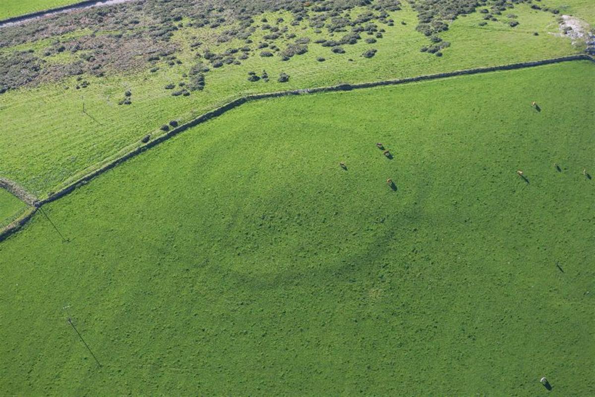
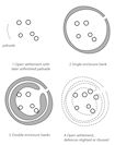
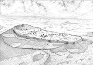
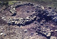
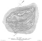
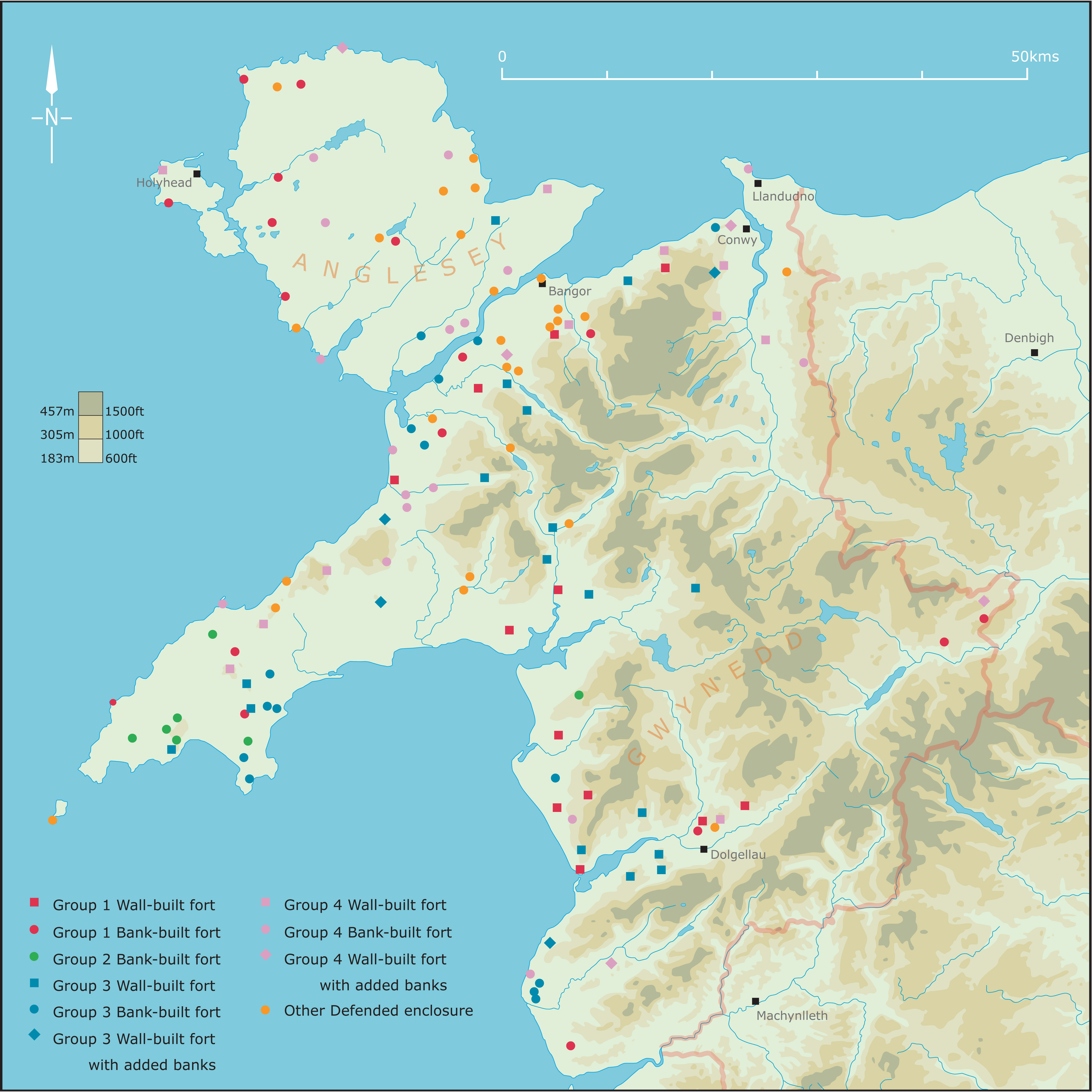
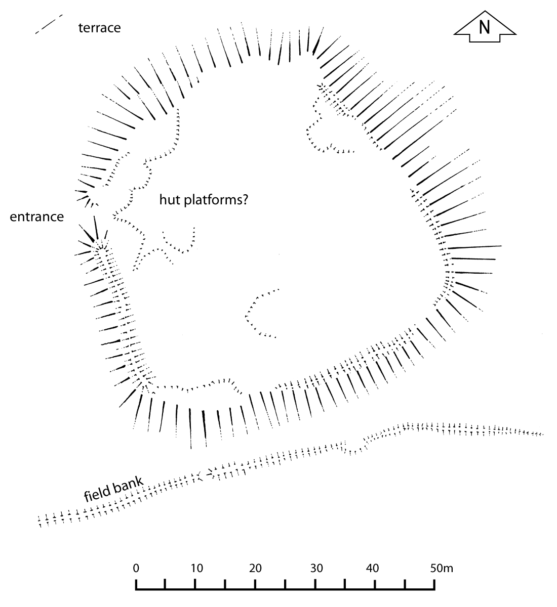
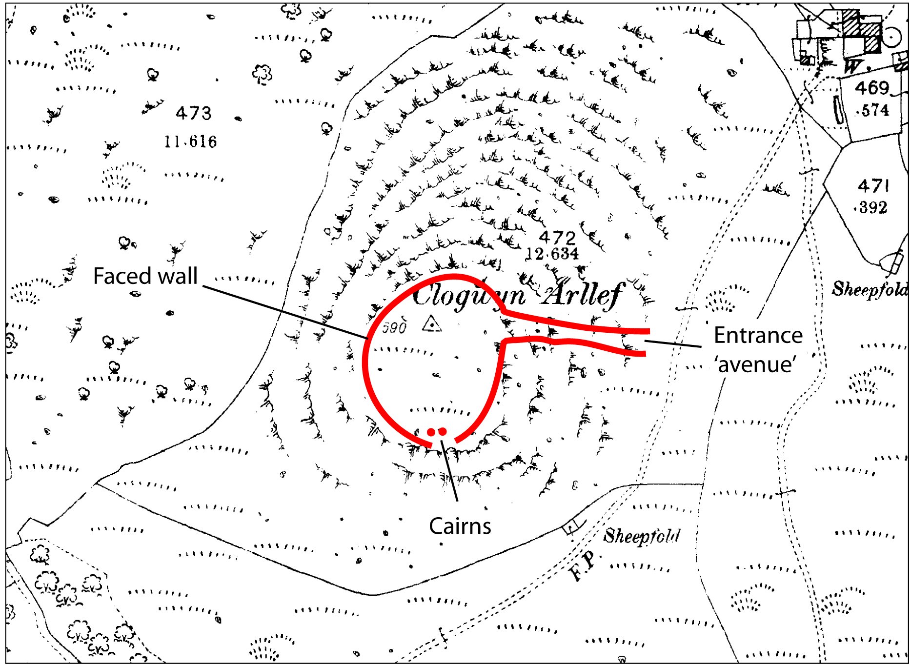
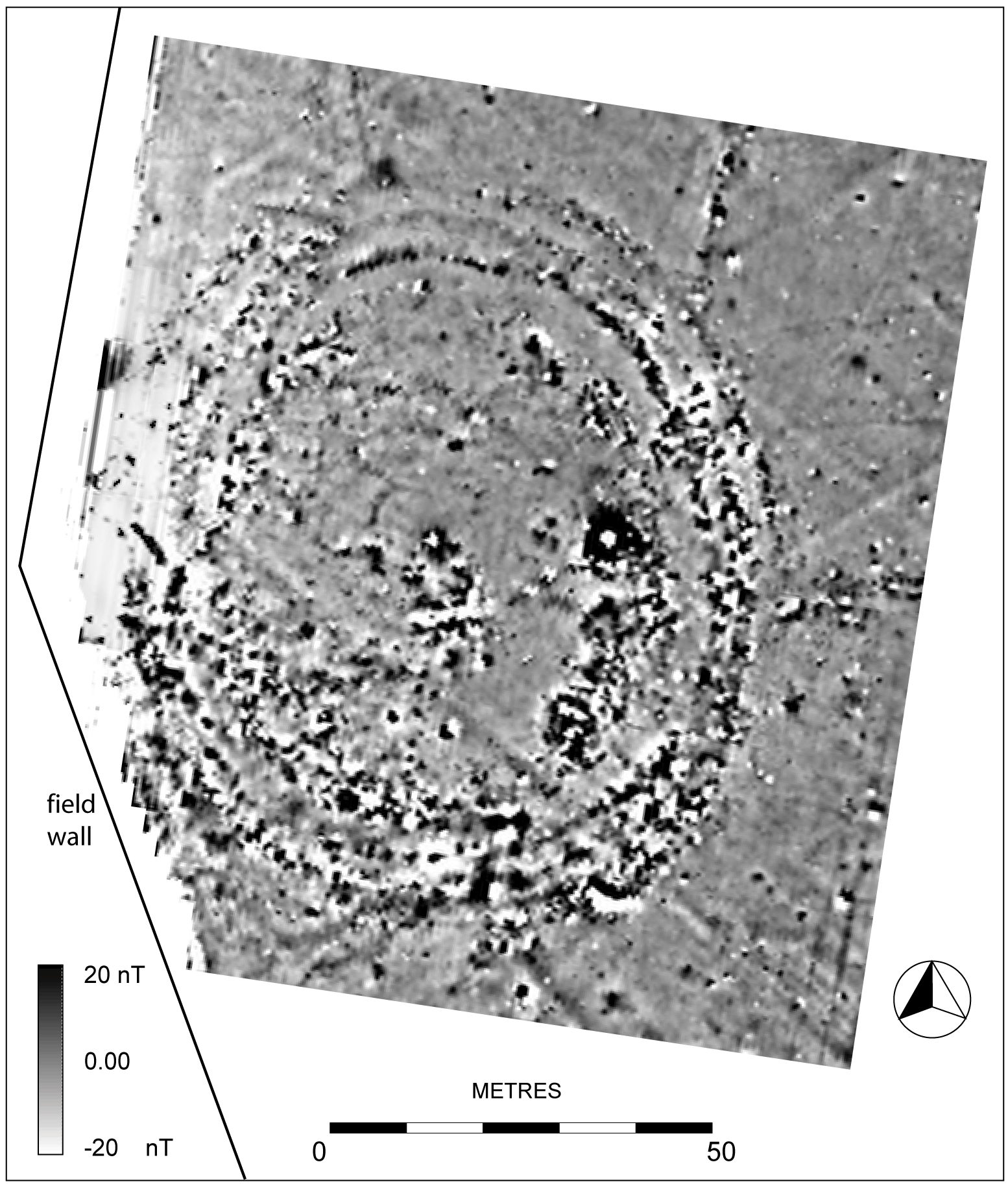
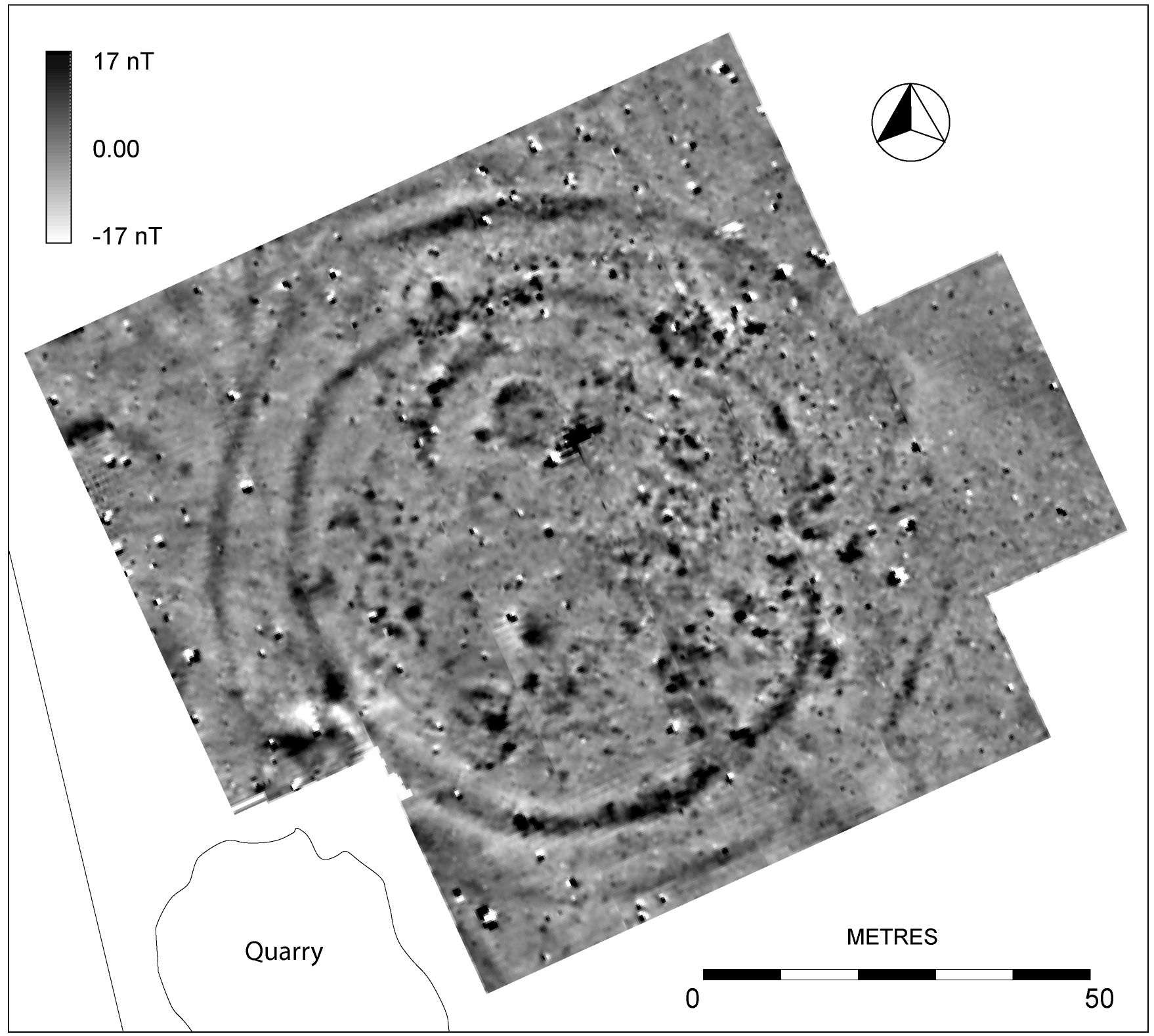
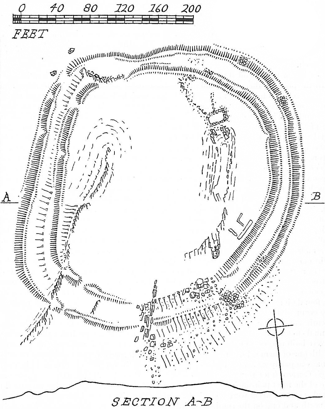
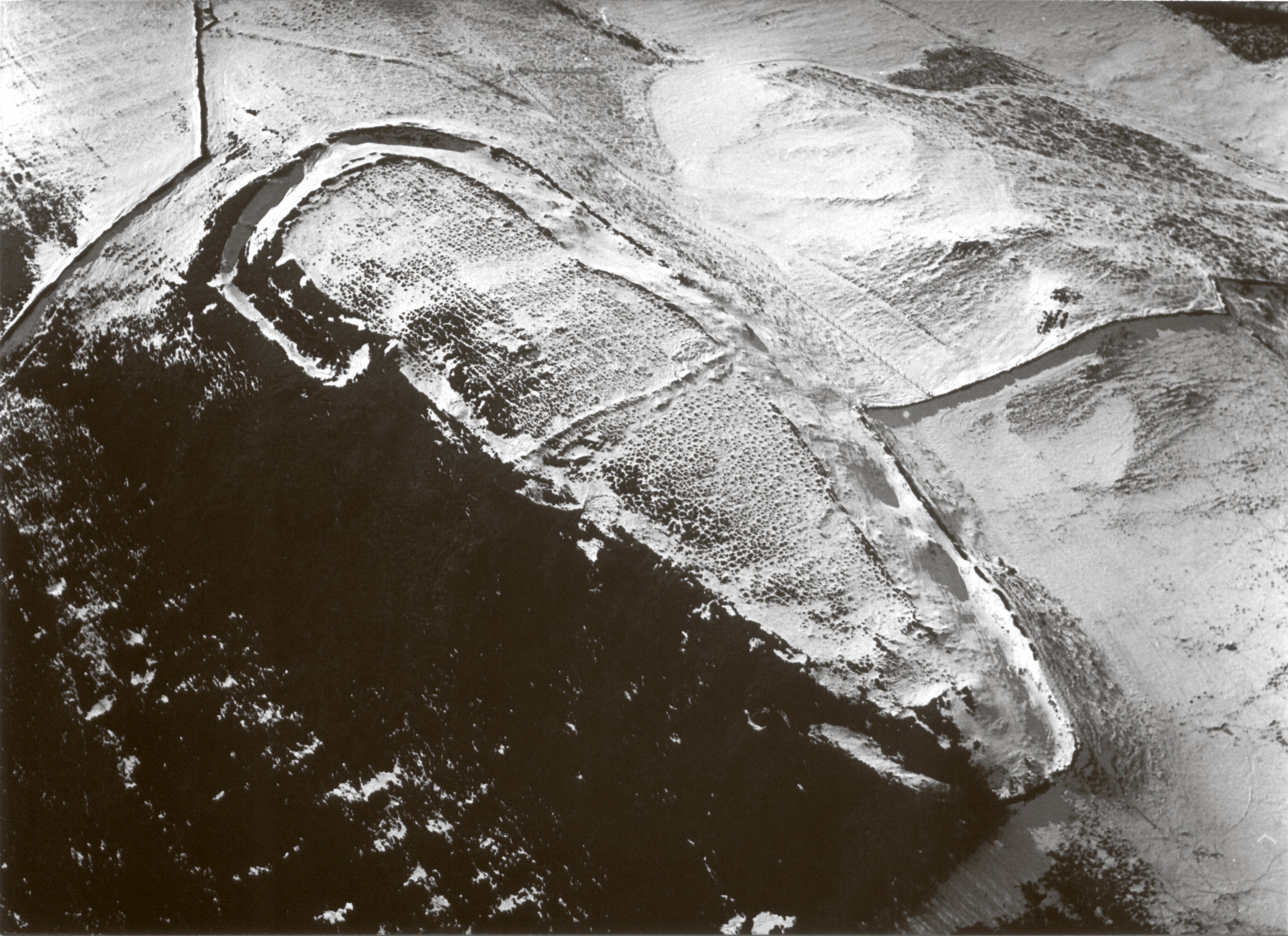
Even with little excavated or direct dating evidence some sense can be made of the great diversity of hillforts by consideration of their size, strength, type of construction and location (Figure 1). The earliest forts are likely to be those that are small and weakly defended (Figure 1, Groups 1 and 2). These include univallate (e.g. Figure 2 and Figure 3), and bivallate examples. Only two of the latter have been excavated. That of Castell Odo, Llŷn (Figure 4), was shown to have begun as an open, undefended hill-top settlement in about the 6th century BC, to which were later added first a timber palisade, then one, then two defensive banks (see Castell Odo). An almost identical site lies a little to the east on the slopes of Mynydd Rhiw at Meillionydd (Figure 5 and Figure 6), shown by recent excavations by Bangor University to have also had a long and complex history (Karl and Waddington 2011). Another very similar fort has recently been identified at Bryn Rhydd, Llŷn (Figure 7), and at least six sites of this type are now known in this area, suggesting some kind of cultural association (Smith and Hopewell 2007). In the uplands of the mainland only one similar site is known, at Moel Goedog, Meirionnydd (Figure 8), although there are a number of smaller single-walled hill-top enclosures that might be of similar early origins, such as Foel Caethle and Clogwyn Arllef, in Meirionnydd (Figure 2 and Figure 3).
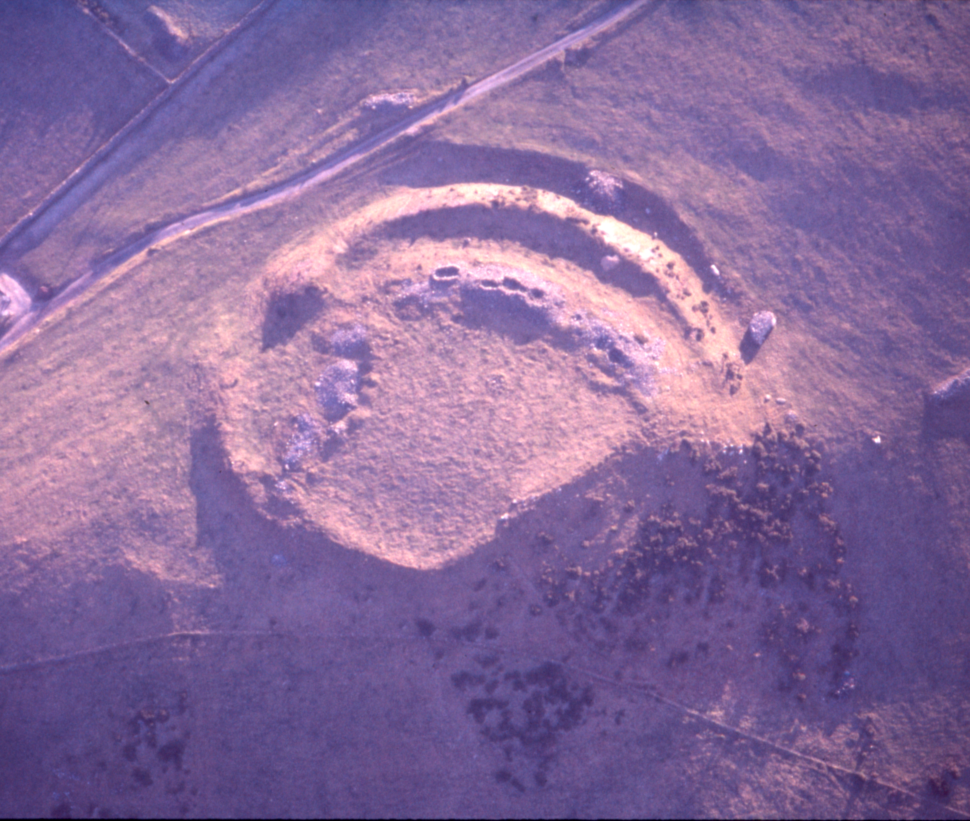
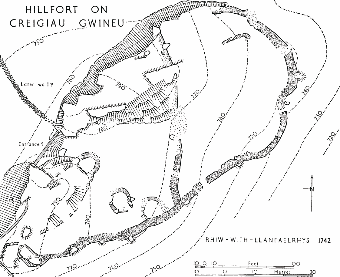
Stronger and more complex hillforts are likely to have been of greater importance and possibly of higher status, holding or serving the largest communities and perhaps acting as 'capitals' of tribal areas (Figure 1, Groups 3 and 4). Some are strongly defended although small, like Castell y Gaer, Meirionnydd (Figure 9), and Creigau Gwineu, Llŷn (Figure 10). Even when large and strong their defences and entrances are generally simple in design (e.g. Figure 11 and Figure 12), compared to the 'developed' later Iron Age hillforts of central and southern Britain. One fort, further east, at Caer Euni, near Bala, Meirionnydd (Figure 13), conforms more to the 'ideal' hillfort design. The nearest fort with well-developed defences is that of Pen-y-corddyn, Abergele in north-east Wales, which is the largest fort in North Wales in terms of internal area. However, there are several in north-west Wales that enclose such large areas compared to the number of houses within them that they seem impractical to defend. They may have acted as refuges for a large population that normally lived elsewhere and the size of enclosure may also be related to the need to protect herds of livestock. The most enigmatic of these large forts is the walled fort of Caer y Twr, Holyhead, Anglesey, enclosing 6 hectares, which has no trace of any internal houses (Figure 11).
Overall, the diversity of types of hillfort in north-west Wales is quite striking, and can be explained by the variety of defensible locations and materials that were available and the complexity of communities to which they belonged, with differing economic lifestyles and needs.
As with the rest of Wales, there have been only a handful of excavations and, of these, only three have provided radiocarbon dates. As suggested previously, the small simple forts are likely to be the earliest, and this observation relies much on the pottery styles and radiocarbon dates from the earliest phase at Castell Odo, showing occupation between the 6th to 3rd centuries BC. Dating of other forts must rely largely on structural evidence. Several forts show the secondary addition of bank and ditch defences to walled forts, suggesting that walled forts (usually without a ditch) were early in the sequence and that ditches and banks were a new design emulating examples from further east in Britain. However, visible evidence rarely shows whether there were earlier phases to forts, because such evidence is masked by later constructions. There are a few stray finds that suggest that forts, or at least the hills they were on, were occupied from the Bronze Age. These include at Tre'r Ceiri a flat copper axe of the early Bronze Age, at Braich y Dinas (Conwy), a middle Bronze Age looped spearhead, at Garn Fadryn (Llŷn), a middle Bronze Age looped palstave and at Tal y Garreg (Meirionnydd), two early Bronze Age halberds (hacking spears). (see Tre'r Ceiri)
Construction or occupation during the Iron Age is difficult to demonstrate, partly because of the lack of excavation and partly because it was a period when pottery was not in use in this area. Thus, although there are several forts that have had some early excavation (before the availability of radiocarbon dating), they generally produced little dating evidence, limited to stone objects such as querns, spindlewhorls, sling-stones or pebble tools. Datable stray finds of all types of that period are rare. Those from hillforts comprise only a bead of middle Iron Age date from Garn Fadryn, Late Iron Age bronzes from Dinas Emrys and a ring-headed iron pin from Din Silwy (Anglesey). Castell Odo was certainly occupied during the middle of the first millennium, as shown by radiocarbon dates, and is the only fort to have produced pottery of that period. However, radiocarbon dating of the small, strongly defended hill-top enclosure at Carrog, Anglesey, has shown that it was probably built about 800 Cal BC (Smith et al. 2014). At the small but strongly defended ditch and bank defended fort of Pendinas, near Bangor, excavation of the rampart showed a single phase construction with a radiocarbon date of 2nd to 1st century BC. Excavation at the small stone-walled fort of Bryn y Castell, (Meirionnydd) produced radiocarbon dates showing occupation during the late first millennium BC to the 1st century AD (see Bryn y Castell) after which the fort was abandoned but later reused, non-defensively, for ironworking in the 2nd to 3rd centuries AD. More recent work at Caer Seion and Pen-y-dinas, Llandudno, has shown that both forts were occupied at least by 400 Cal BC and that developments of the defences at Caer Seion, previously regarded as late additions, were in fact being built about that date, so these large forts may have quite early origins (Smith et al. 2011).
In contrast to the scarcity of evidence for the origins of hillforts there is more plentiful evidence in the form of pottery and coins for occupation of several of them during the Roman period, suggesting some continuity of settlement. In view of the hostility and force of the Roman invasion one would expect that the defences of forts were slighted or at least not maintained during this period. However, recent excavation at Tre'r Ceiri has shown that the main entrance was remodelled during the 2nd century AD, suggesting that there was local independence, at least for self-defence, presumably in response to threats from outside, perhaps raiding from Ireland. It may be that in most cases hillforts were abandoned during the early part of the Roman subjugation of the area but re-occupied later. Possible evidence of this is that only one fort, Braich y Dinas (Conwy), has produced 1st-century Roman material (see Braich Y Dinas). Some forts do not show evidence of use during the Roman period and it has been suggested that these were forts that resisted the Roman advance and were deliberately slighted and cleared of their occupants. Slighting of defences has been suggested at Caer Seion (Conwy) and Caer-y-Twr (Anglesey). Possible evidence of burning of ramparts has also been identified at Pendinas (Bangor) and Caer Euni (Meirionnydd). Bank ramparts were added to Caer Seion and to Caer Euni, as well as to Caer Bach (Conwy), Dinas Dinorwic, Pen y Garreg and Craig y Dinas (Caernarfon). The addition of banks and ditches to walled forts may have been a reaction to the Roman threat as there was a lapse of some thirty years between the initial invasion of Britain and the eventual subjugation of Wales. This period must have seen considerable upheaval, with movement west of displaced peoples, and may have included the abandonment of some hillforts and new construction or strengthening of other hillforts.
The north-west is unusual for the considerable number of examples of roundhouse settlement that survive, of which around 1000 are known. Better understanding of this huge resource has been made possible by a major fieldwork survey that was carried out between 1994-1997 with funding from Cadw (Smith 1999). Information from the survey was later incorporated into a more detailed settlement study (Waddington 2013). Comparison of the distribution of these with that of hillforts provides an opportunity to explore the relationships between them (Figure 14). Those areas where concentrations of roundhouses coincide with the presence of hillforts are chiefly around the western fringes of the upland. There are other areas, mainly on Anglesey, where hillforts are present but no corresponding concentration of roundhouses. Finally there are areas with numerous known roundhouses but no hillforts, mainly in the upland of Snowdonia and Meirionnydd.
It is important to realise that the distribution of recorded sites of roundhouse settlement does not adequately represent the actual distribution of settlement, since its occurrence is strongly influenced by survival and by the intensity of fieldwork. For instance, much of lowland Llŷn and Anglesey has very few recorded roundhouses because of clearance for agriculture. Some localised areas have been much more intensively surveyed than others, leading to a fuller record, for instance in central Meirionnydd, north-east Llŷn and northern Snowdonia, which have been the subject of detailed surveys for the RCAHMW. These areas of better record give some indication of the true original density of population at the time of the hillforts.
Anglesey has the lowest density of known roundhouse settlements in north-west Wales, with an average of only 12.3 settlements per 10km square compared to 40 to 50 per 10km square on the nearby mainland. However, it has a much larger proportion of good agricultural land We should expect, therefore, that it would have had the highest population in the region and the low number of recorded Iron Age/Romano-British settlements must be put down to poor survival in an arable landscape. This supposition has been supported by recent archaeological work in advance of the new A55 road across Anglesey, which provided a sample transect over improved farmland where no archaeological remains had previously been recorded. It is obviously not a random, nor a representative, sample since it follows the better-drained centre of the island, while the hillier and rockier land to the east and the low-lying, valley bogs and marshes to the west mean a greater proportion of agriculturally marginal land in these areas. If we assume, for the sake of illustration, that the average settlement capability is about half that of the A55 transect, which is about 22km long by about 100m wide, on average, then the discovery of three new Iron Age to Romano-British settlements within this transect is equivalent to about 490 such undiscovered settlements overall. This means a settlement density of about 68 per 10 km square or 1 settlement about every 1.5 sq. km and indicates an almost completely utilised landscape, as it is today. While these figures seem high, and in reality settlement would be unevenly distributed, they are certainly no higher than the density evident in some of the best-preserved areas of Romano-British landscape on the mainland, such as those around Rhostryfan (Caernarfon) or Cwm Ystradllyn, Garndolbenmaen. The true population of the uplands then comes into focus as the known settlement density is almost complete and concentrated around the fringes of the upland (Figure 14). It is these estimates of population density against which the presence of hillforts and other defended settlements must be compared.
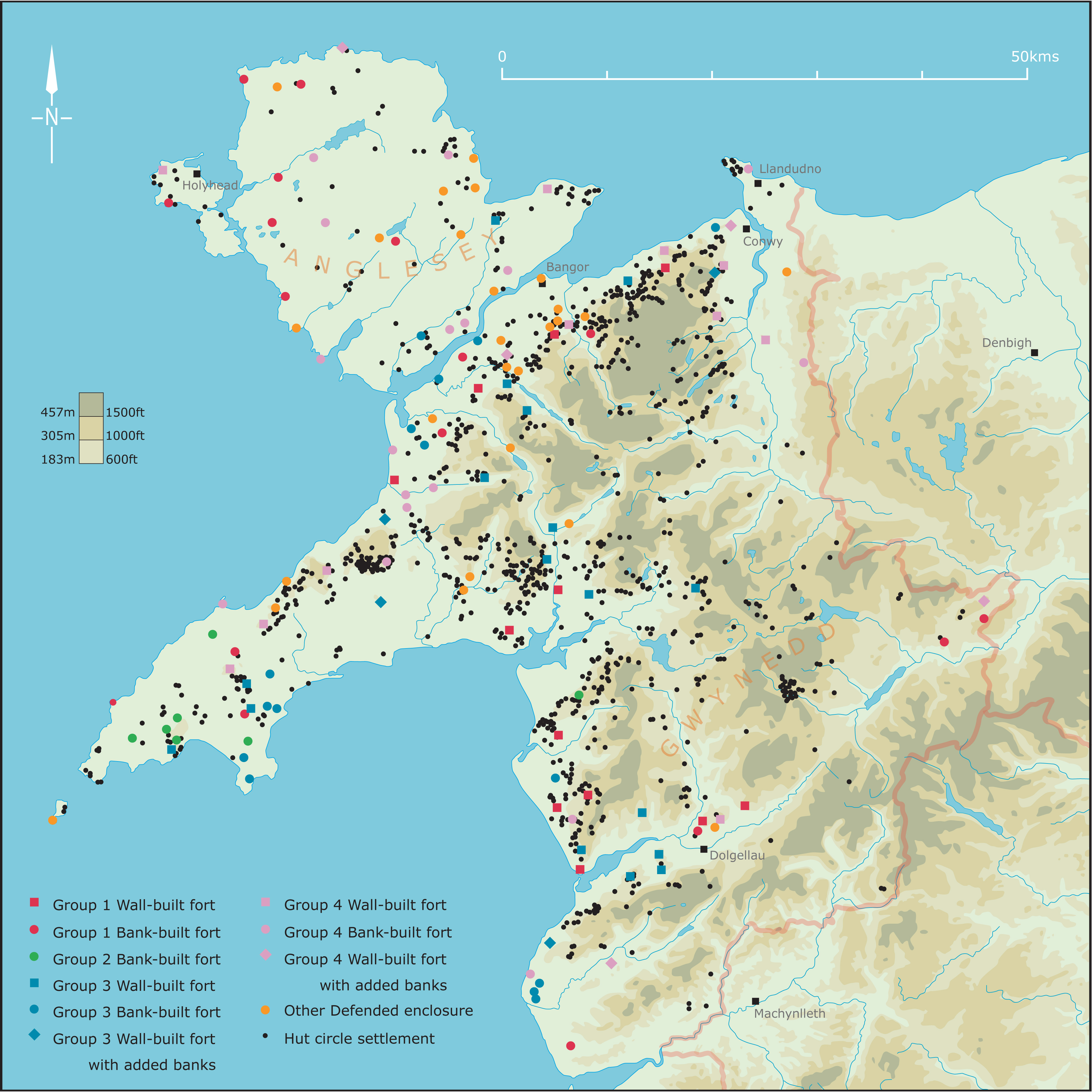
Despite the large estimated population of lowland Anglesey, the few major defended enclosures are quite widely distributed. These make use of relatively low inland hilltops, or inland or coastal promontories. There are, however, also a number of smaller defended enclosures. Some of these have concentrations of roundhouses and were clearly working settlements, perhaps of greater status than, but otherwise little different from 'open' (i.e. unenclosed) settlements in the same area. The presence of good-quality land and of a high estimated population might be expected to lead to the development of centres of status and authority and the few strong forts represent the most likely centres. The modern population of Anglesey is still largely agricultural and fairly evenly distributed and may have been so during the Iron Age. This may be reflected in the fairly even distribution of defended sites on Anglesey, as if each had a specific territory (Lynch 1991, 259).
| Altitude, metres OD | Total no. of houses | Average internal diameter, metres | No. of houses in nucleated or enclosed settlements | Average internal diameter, metres |
|---|---|---|---|---|
| 0-100 | 323 | 6.7 | 214 | 7.0 |
| 101-200 | 380 | 6.4 | 211 | 6.5 |
| 201-300 | 432 | 6.1 | 286 | 6.0 |
| 301-400 | 278 | 5.3 | 64 | 5.7 |
| 401-500 | 86 | 4.4 | 7 | 4.3 |
| >500 | 27 | 4.1 | 1 | 4.0 |
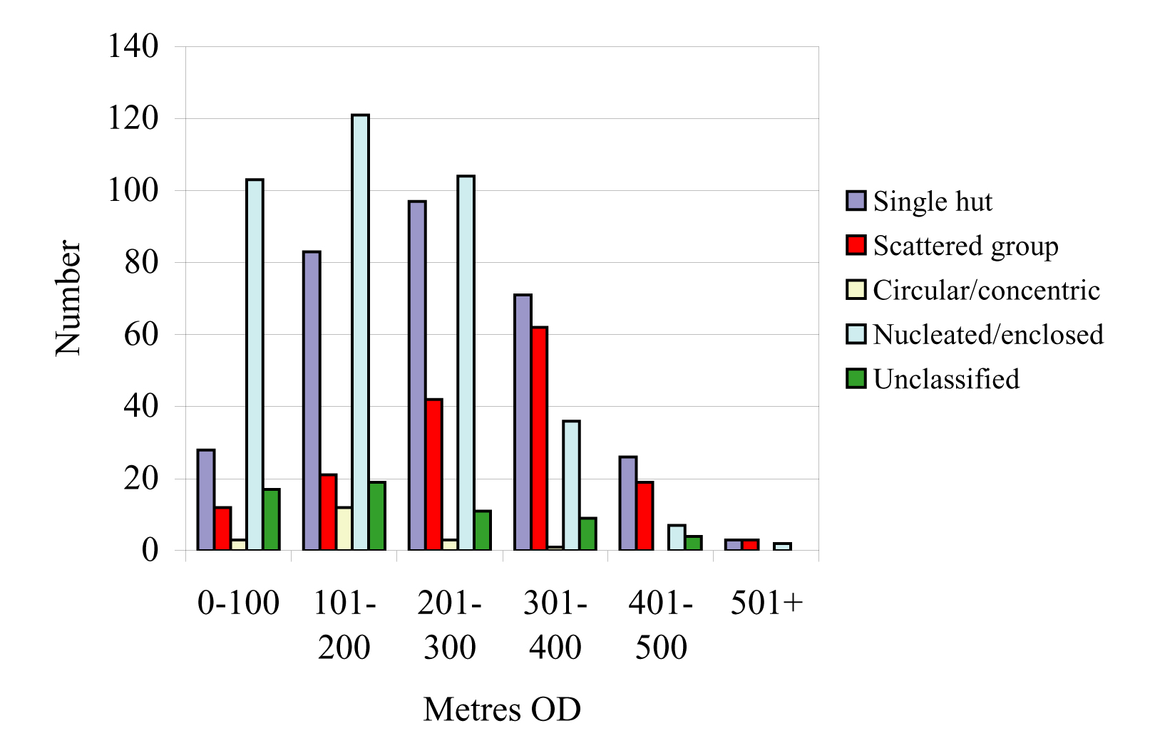
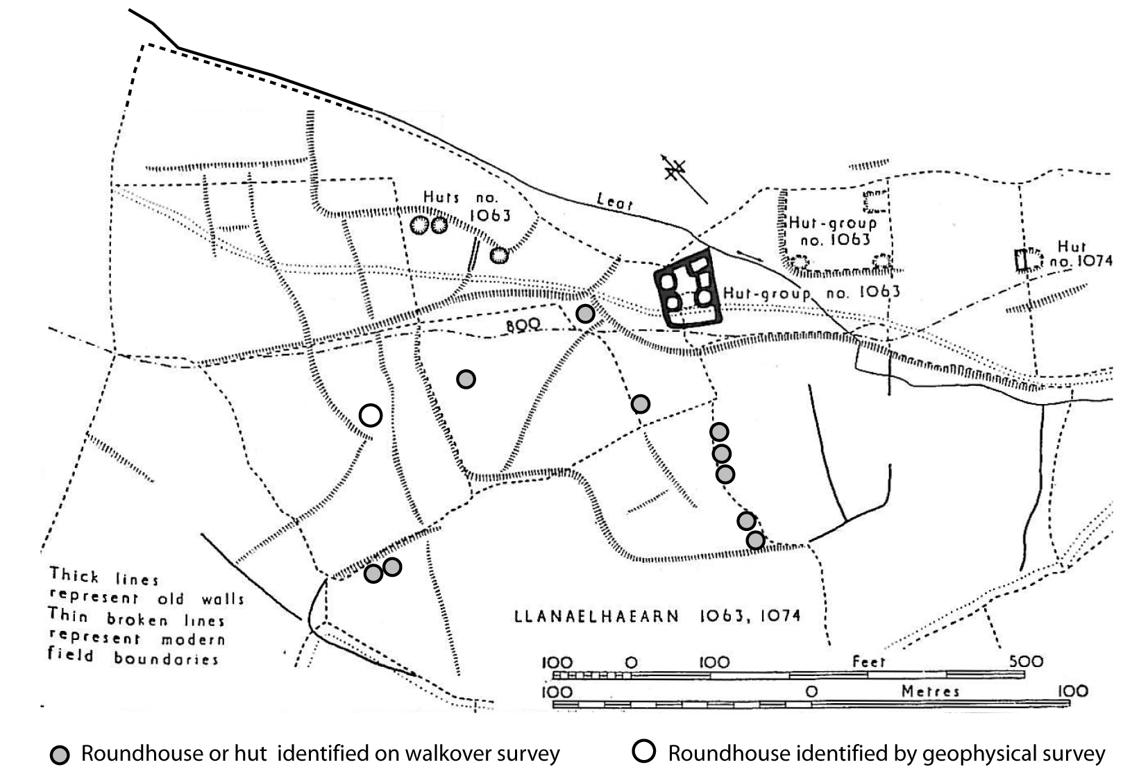
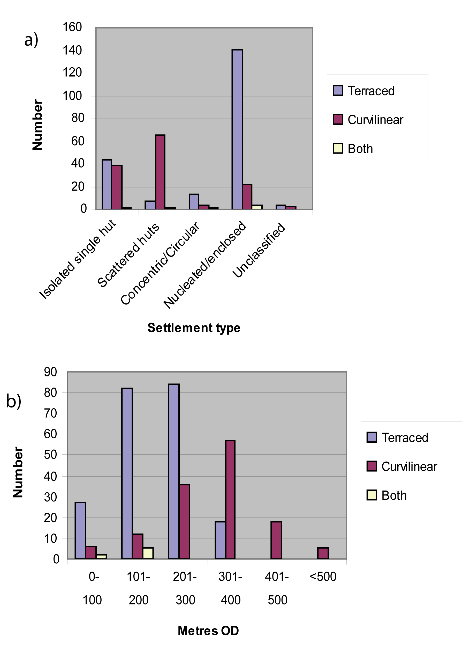
A great variety of settlement types exist within north-west Wales and the distribution of these sites in the mainland is much wider than that of hillforts. Settlement types include isolated single houses, unenclosed isolated, scattered or loosely grouped houses, concentric sub-circular enclosed settlement, sub-circular or rectilinear enclosed settlement, nucleated groups of huts either isolated or set within yards. Altogether the distribution of different types of settlement is closely related to altitude (Figure 15). The single and scattered unenclosed huts are more typical of the uplands (e.g. Figure 16). Concentric enclosed settlements consist usually of a single large roundhouse set centrally within a concentric enclosure ditch. There are relatively few of these and they occur at various altitudes (e.g. Figure 17, a and b). The enclosed or nucleated settlements of sub-circular or rectilinear plan are typical of the lowland or the fringes of the upland (e.g. Figure 17, d, e and f). The shape of rectilinear enclosed settlements was once thought to indicate Roman influence but excavation has since shown that these were Iron Age farmsteads in origin. The presence of roundhouse sites widely scattered within the central uplands where hillforts are absent is notable. Meirionnydd has some enclosed settlements around the western fringes of the upland but inland is characterised by isolated single houses or dispersed or scattered settlement like the higher uplands of Snowdonia. Analysis of all known roundhouse sites shows that house sizes on average get smaller with altitude and this, with the scattered nature of settlement at higher altitudes, probably indicates seasonal occupation for pasturing (Table 1). However, even houses of enclosed and nucleated settlement more typical of lower altitudes and more likely to be permanent show this decrease in size with altitude. The change may therefore be more to do with availability of suitable sized timber.
The distribution of defended sites is concentrated around the periphery of the upland of the north-west. Interpretation of possible territories in this area is complicated by the variation in the types of defended enclosures, which may, therefore, be of different periods or of different status. The settlement in that area is characterised by small enclosed or nucleated but unenclosed sites, or settlements within walled yards (e.g. Figure 17g and h). The frequent occurrence in the fringes of the uplands of settlements within yards may be associated with keeping stock and grazing the uplands. They also include areas of terraced fields (discussed further below) and contrast with the lowland settlement of Anglesey, for instance, where some settlement was enclosed but the majority seems to have been unenclosed and open, not set within yards.
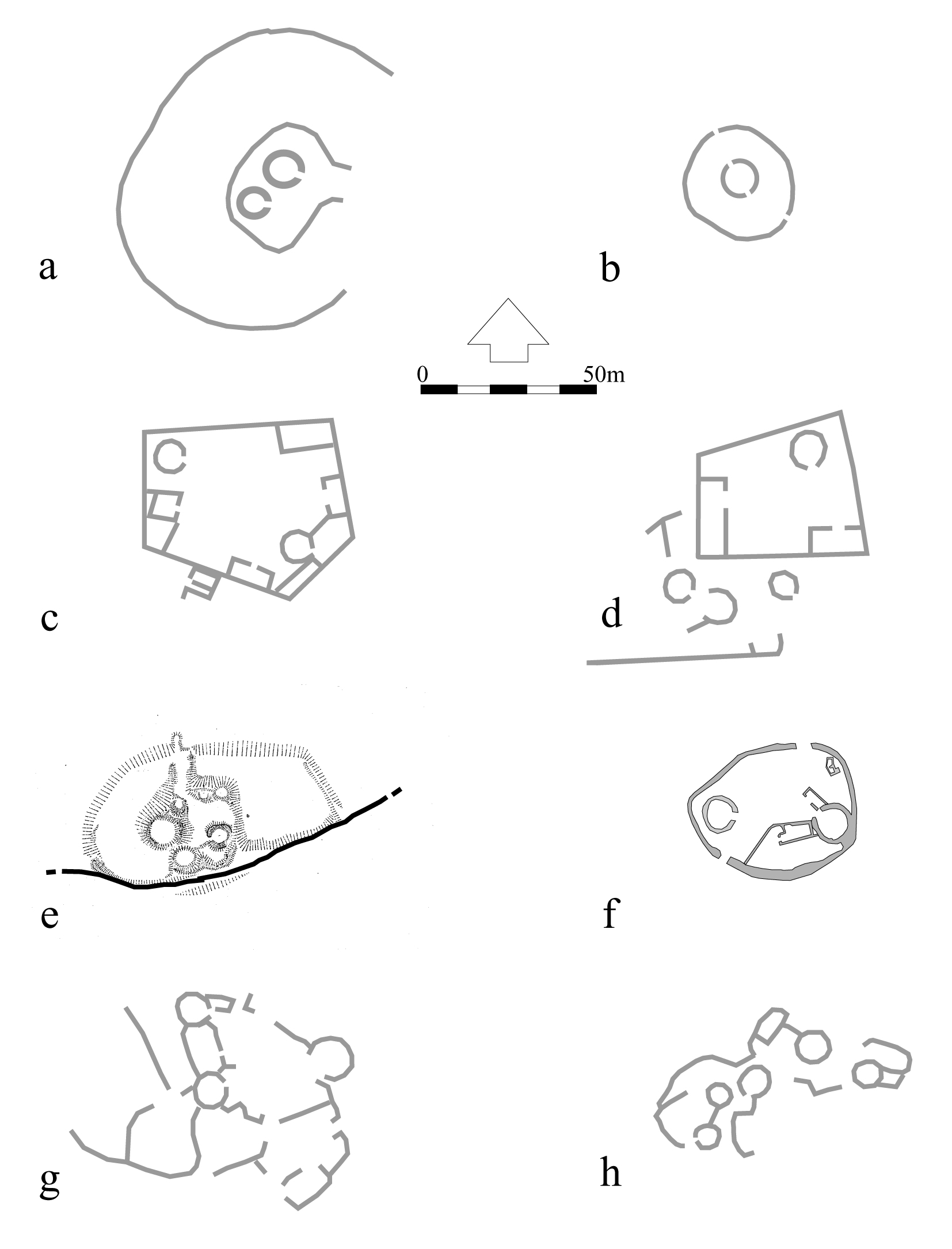
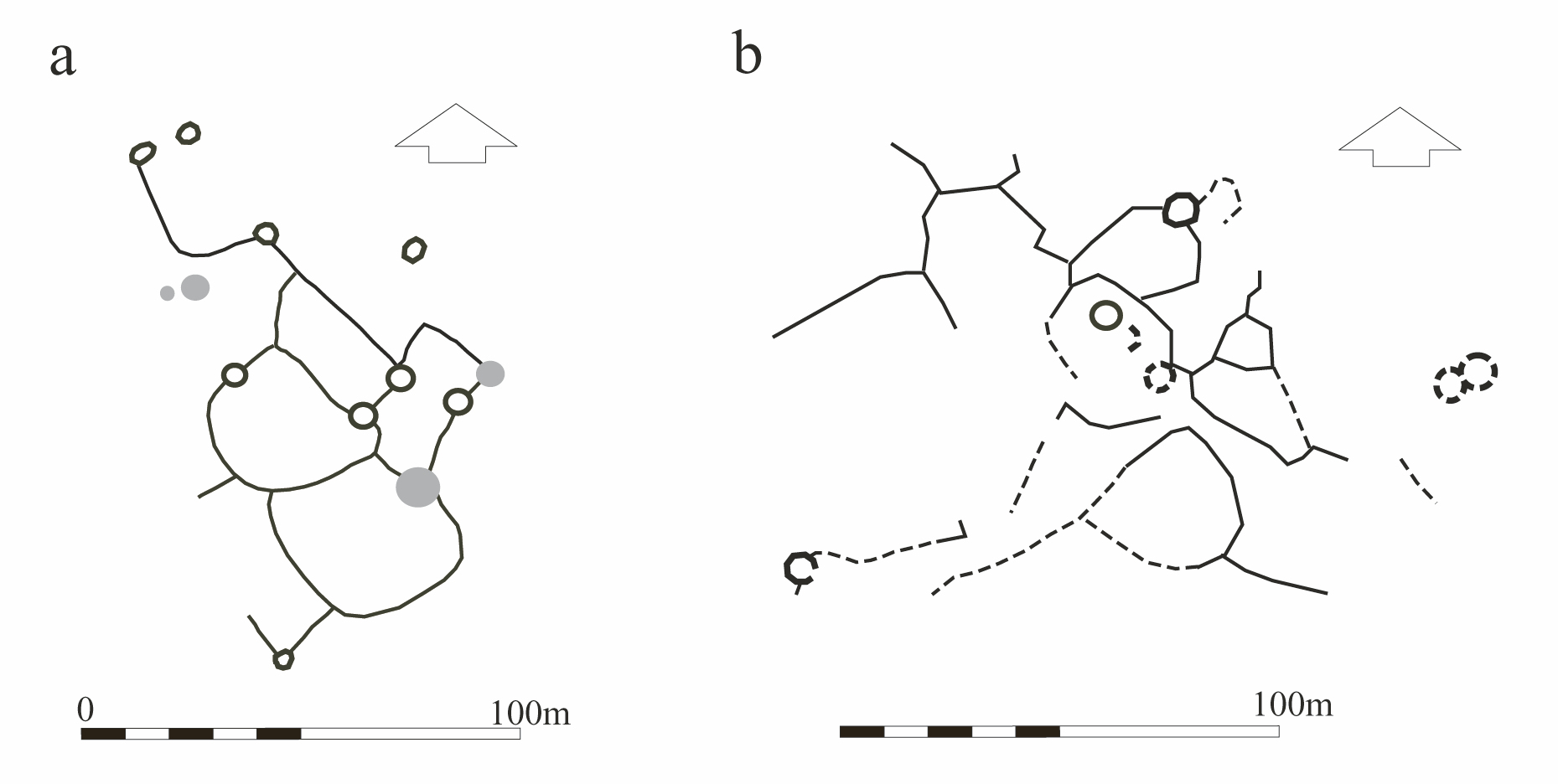
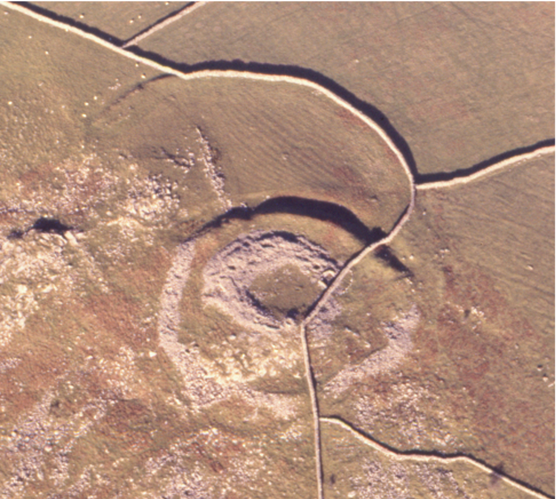
It is difficult to relate any of these settlement types to hillforts but possible factors are proximity, comparison with house types within forts and dating evidence. Excavation elsewhere in Wales shows that the earliest defended hilltop enclosures were built around the end of the Bronze Age, for example that at The Breiddin, near Newtown (Musson 1991). In north-west Wales the site of Castell Odo (Llŷn), discussed above, began as an open settlement, only later having two concentric rings of defences added. This and the other similar concentric ringwork sites in the same area seem to echo a common settlement style represented in a number of smaller enclosed farmsteads, the earliest of which so far identified being that of Mellteyrn Uchaf (Llŷn) (Figure 17a) dated to around the end of the 2nd millennium BC (Ward and Smith 2001). There are a few settlements of similar plan in the north-west, including two excavated in Meirionnydd, Moel y Gerddi (Figure 17b) and Erw Wen, which began around the middle of the first millennium BC (Kelly 1988). The houses at Mellteyrn Uchaf had thick clay walls and varied from 4.2m to 6.6m in internal diameter. The small size of these houses may be typical of the period and is comparable with the small platforms assumed to be house sites at some upland settlements, e.g. Pant yr Griafolen, Conwy (Figure 24b). The Moel y Gerddi and Erw Wen houses were timber walled and larger, at 10m overall diameter, as were those of the earliest phase of settlement at Castell Odo (see Castell Odo).
Ringwork hillforts and concentric enclosed settlements are quite rare overall in the north-west and it is likely that they represent not just early settlement but just one element of the population, perhaps that of higher status, and that there were also other scattered houses. If these were clay-walled or of timber they would be unlikely to survive in the lowland, and even in the uplands small platforms would be difficult to recognise as house sites without accompanying enclosures. It may be that other areas of the north-west had defended enclosures of a rather different type in this period and the likely candidates are the small, lightly defended walled hilltop enclosures like that at Clogwyn Arllef, Llanbedr (Meirionnydd) (Figure 3). No examples of this type of enclosure have yet been excavated, so their date is unknown.
Timber post or stake-walled or clay-walled houses seem to be typical of the first millennium BC. Roundhouses with an internal post-ring supporting the roof are a widely known type of construction in this period in Wales, for instance at Walesland Rath, Pembrokeshire (Wainwright 1971) and Lawhaden, Dan y Coed and Woodside, Pembrokeshire (Williams and Mytum 1998). A stake-walled roundhouse, 8.5m in diameter, has recently been found by chance during excavation at Parc Bryn Cegin, Bangor, and was radiocarbon-dated to between the 6th to 5th century BC. It was probably subordinate to a similar but unusually large house, 15m diameter, about 800m away, which was set in the centre of a circular henge enclosure of Neolithic date (Lynch and Musson 2004) creating a concentric enclosure by reuse of the earlier earthwork. Other stake-walled roundhouses have been found at Crawcwellt, near Trawsfynydd (Meirionnydd) (Crew 1998). These houses were occupied between c. 300 BC until probably a little before the Roman invasion and were all very similar in design, varying between 8-10m in diameter with stake walls, later replaced by stone walls. This use of timber-walled houses has been suggested to demonstrate a period when timber was plentiful, being later succeeded by houses with stone walls (Kelly 1988). However, it could also represent a development in construction by which earth-fast timbers, prone to rot, were avoided, thus prolonging the life of the building. A similar explanation could also explain evidence from two excavated settlements at Bryn Eryr, Anglesey, and Bush Farm, Caernarfon, where clay-walled houses of about 2nd century BC were succeeded by smaller, stone-walled houses in the Roman period (Longley et al. 1998).
If timber-walled houses were typical of the pre-Roman Iron Age they should also be characteristic of the hillforts built in that period. Such houses will survive only as platforms, not stone 'hut circles'. Where hillforts were also in use during the Roman period, as many clearly were, traces of earlier timber house platforms may have been erased by construction of stone-walled houses. Similarly, those hillforts where platforms do survive may not have been occupied in the Roman period. Such seems to be the case at Caer Seion (Conwy) (Figure 29), where excavation has shown no evidence of occupation during the Roman period. Other examples of forts where only platforms are found but no evidence of Roman-period occupation are Pen-y-gaer (Conwy), Pen-y-gaer (Llŷn) and Caer Euni, Bala (Meirionnydd). In contrast, several forts with stone-walled huts do have evidence of occupation in the Roman period, for instance Braich y Dinas (Conwy), Tre'r Ceiri and Garn Boduan (Llŷn).
Stone-walled or stone-faced earth, clay or rubble-walled roundhouses form the largest part of the known settlement evidence in the north-west and most of those houses excavated have produced evidence of occupation during the Roman period. However, modern excavations with the benefit of scientific dating have been able to show that such sites had earlier origins. Also, stone-walled houses have recently been found during excavations of an unenclosed settlement at Parc Cybi, Holyhead (Anglesey), and these appear to have been abandoned before the Roman period judging by the complete absence of Roman material (Kenney pers. comm.). Despite the widespread evidence of Roman-period occupation of roundhouse settlements elsewhere, their distribution must also be taken as indicative of the population during at least the later first millennium BC.
Many enclosed settlements also show another feature, the appearance of rectangular buildings. The origin of these has not been dated but it seems likely that they were a development during the Roman period. They appear to have been in contemporary use alongside roundhouses. The latter may have continued as domestic housing while the rectangular buildings were industrial, agricultural or other specialised buildings (Figure 17, c-d). Similar large buildings do not occur in hillforts, although some smaller rectangular buildings do occur, e.g. at Tre'r Ceiri, Braich y Dinas and Garn Fadryn. At Tre'r Ceiri, these appear to have been later additions to a settlement that originally consisted of a few large roundhouses. The multiplicity of small huts there could mean that population within the fort outgrew the available area or that functions became more specialised, with additional huts becoming 'rooms' for craft activity or storage. A similar case can be made for a farmstead, Fridd Ddu, near Trawsfynydd, which seems to have begun as a single large roundhouse within a concentric enclosure to which was later added a rectilinear annexe and several very small huts grouped around a yard (Figure 17e and Figure 19). Such a specialisation meant that within a larger settlement each family unit became more self-contained and less communal. It meant that a number of huts were needed and this could be expected to develop into a multi-roomed dwelling, something impossible with a single roundhouse. Three (undated) settlements on the south-facing slopes of Mynydd Graig Goch, Dolbenmaen, Llŷn, show a further stage in this process in which groups of small huts set around a small yard formed a single settlement unit (e.g. Figure 19 and Figure 21). This style of settlement unit developed into what was just a series of adjoining or conjoined rooms around a yard set within a small enclosure. There are about 50 of these in the north-west and they are very similar in style to those known as 'courtyard' houses belonging to the Romano-British period in Cornwall. Those in north-west Wales seem to be just a sub-type of larger enclosed settlements and are also likely to be developments in the Roman period but it has been shown that in some cases they were constructed over earlier timber roundhouses (Kelly 1988, 145-7) and in one case, near Harlech (Meirionnydd) there is a suggestion of development from a concentric type settlement enclosure (Figure 18).
The north-west is fortunate in having numerous well-preserved hillforts and settlements but there are also some exceptional areas of relict field systems and these provide an insight into the nature of Iron Age and Romano-British agriculture. Two broad types of field enclosure have been identified, rectilinear terraced fields and curvilinear fields without terracing although this division is not exclusive (RCAHMW 1964). It is believed that terraced fields were primarily arable and ploughed while curvilinear fields were used as stock enclosures. There is a close relationship between terraced fields and enclosed settlements, first noted by the RCAHMW and borne out by recent survey that also showed a relationship between settlement type, field type and altitude (Figure 15 and Figure 27). At one time it was also thought that there was a chronological difference, with curvilinear enclosures representing an early stage of clearance and farming in the uplands. However, this has not been proven and the variation may be more to do with different types of farming. Most settlements with terraced fields occur below 300m (1000ft) while most settlements with curvilinear fields occur above that height. Enclosed homesteads do occasionally occur at higher altitudes but without terraced fields. The 300m contour marks the approximate altitudinal limit of arable cultivation. There would therefore be fluctuations of agriculture and settlement within this marginal zone during periods of better or poorer climate, and enclosures above that zone would in all probability be stock enclosures rather than arable. This has yet to be proved by scientific study of fields because early arable cultivation by ard or scratch plough would not have created terraces. Equally, there is no proof that the terraced fields were not ploughed by an ard. These areas of better land were also often reused in the medieval period, as demonstrated by the occurrence there of buildings of that date. Where that happened existing systems of small rectangular fields can be expected to have been modified to allow longer runs for a plough team.
Some areas of relict fields are directly associated with settlements but the actual relationship between settlements, fields and hillforts is more difficult to prove. Some hillforts are situated at quite high altitudes, beyond the normal limit for arable cultivation and, not surprisingly, do not have terraced fields nearby and therefore pasture is the only likely nearby agricultural activity. Several forts do have curvilinear enclosures attached and these could be for stock or for cultivation, while some forts enclose such a large area that stock could be corralled within the fort itself if necessary (e.g. at Caer y Twr, Figure 11). The largest part of the mainland of north-west Wales is upland, which is only suited to pasture and much of that would have been poor, requiring mobility and seasonal movement. This kind of land-use would potentially have led to disputes and needed territorial agreements over boundaries or areas of common use. This may have been a factor in the creation and location of defended enclosures. Dispersed flocks or herds were vulnerable to theft but their mobility also meant they could be moved for safekeeping. The location of arable farming was fixed and its products required secure and careful storage. Such was provided by rectangular raised granaries within settlements and examples of these have been found on Anglesey at Bryn Eryr, Cefn Cwmwd and Parc Cybi. In some cases the need for communal security of such products may have been a factor in the existence of defended enclosures, and excavation within some hillforts, such as at Moel y Gaer (Flintshire), has shown the presence of numerous, possible granary, structures (but see Guilbert this issue, also 1976).
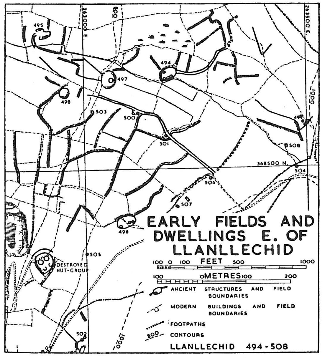
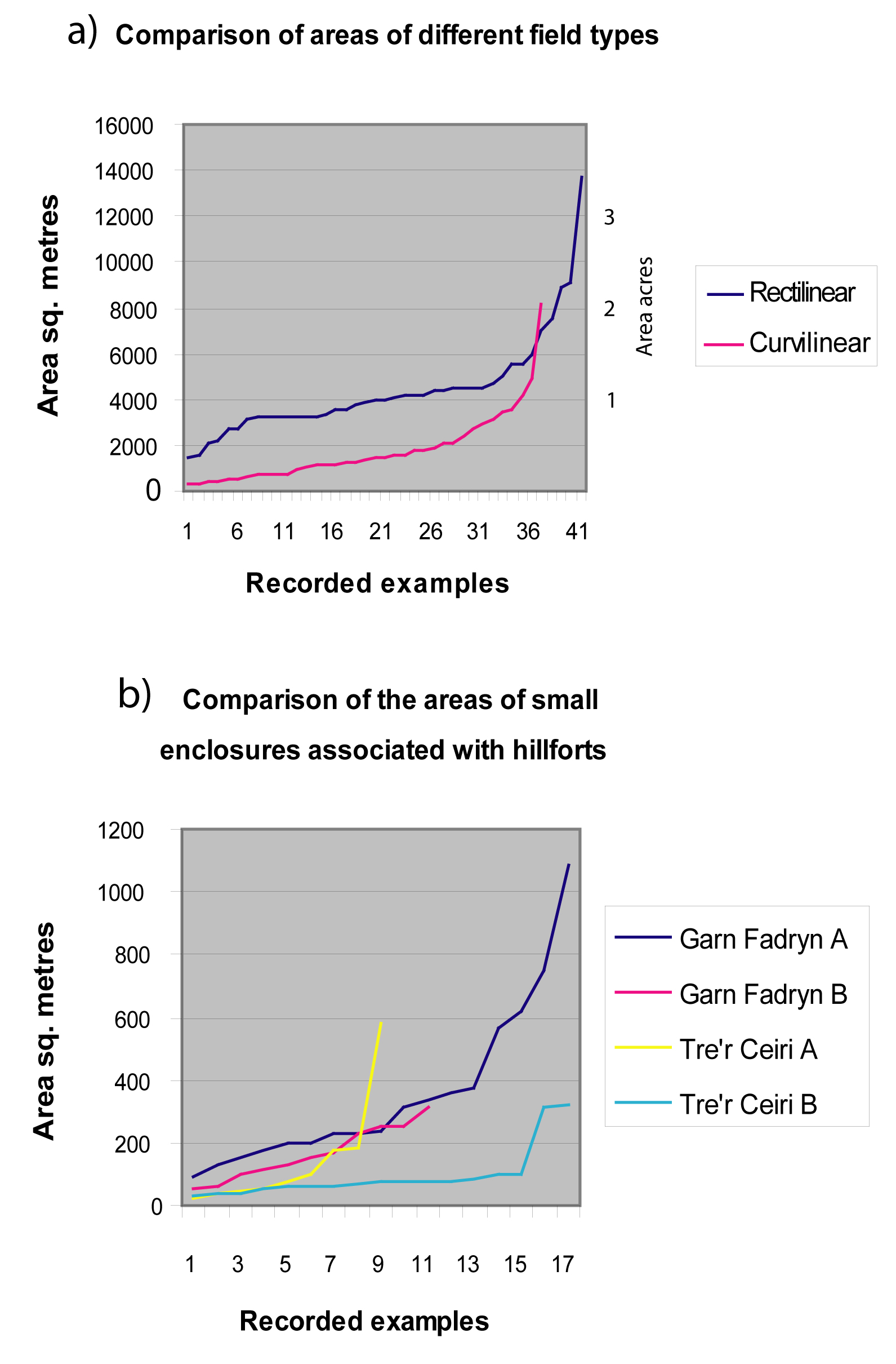
Of over 200 recorded examples of early terraced field systems in the north-west, only a few survive over a sufficient area to give a good idea of the overall pattern of the landscape and of the size of individual farming units. These show field patterns that, although rectilinear in character, had been laid out to respect the contours within local areas, for example at Llanllechid, near Bangor (Figure 20), or just below the hillfort of Pen-y-gaer (Llŷn) (Figures 21 and 22). The most complete examples of field systems associated with settlements suggest that the arable area associated with each was in the order of 4-8ha (10-19 acres) (Fowler 1983, 127). There is no suggestion anywhere in north Wales of widespread planned division of the landscape as has been found in parts of lowland Britain and Dartmoor.
The terraced fields vary both in size and proportions but analysis of complete recorded examples shows that they are predominantly short and broad and the majority have an area of around 0.4ha (1 acre) (Figure 23). This could be significant, because an acre was the standard size for a medieval strip and regarded as the area that could be ploughed in a day. It has also been noted that the areas of individual 'Celtic' fields on the chalk Downs of southern England fall mainly between 0.2-0.6ha (0.5-1.5 acres) (Fowler 1983, 108).
The best surviving examples of terraced fields occur at higher altitudes around the limit of arable farming, where they have survived because these areas have not been used for modern farming. This suggests that they were created and used during a period of more favourable climate. The reuse of the same area (and subsequent abandonment) during the medieval period happened for the same reason and this occurred during a period of improved climate between the 10th to 13th centuries (Parry 1985). The survival of these fields must not disguise the fact that there must have been similar and much more numerous fields in the lowland that have all been erased by subsequent agriculture, with a few examples surviving on steeper slopes that are less suitable for modern arable farming.
There are fewer known examples of curvilinear field systems associated with roundhouse settlement and all are at higher altitudes than terraced fields (Figure 27b). Most are associated with stone-walled roundhouses so may be of similar date to the terraced fields but of different function. The occurrence as isolated groups of features within extensive upland means that they represent primary colonisation. This kind of open upland could easily have been laid out as a planned, regularly divided landscape but clearly developed 'organically' as individual settlements, in one case expanding concentrically at Ceunant y Ddol (Figure 24a).
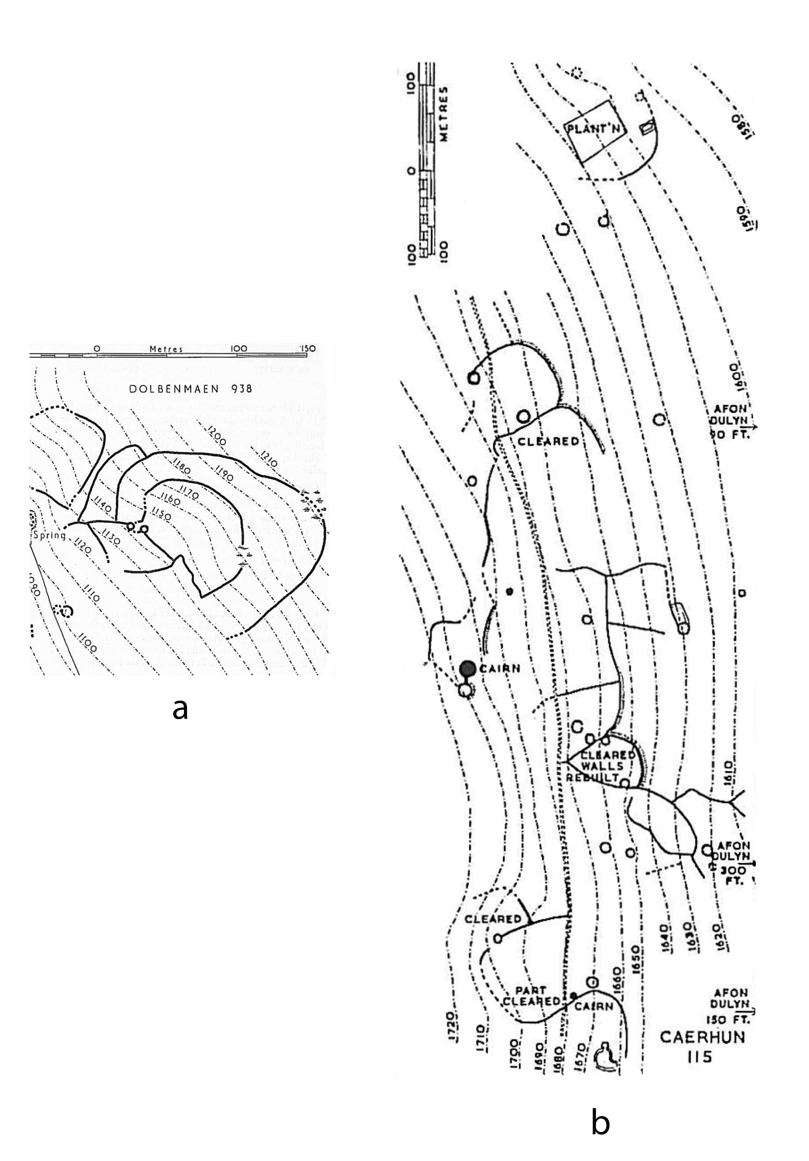
At Pant yr Griafolen (Conwy) the field enclosures are attached bead-like to a long meandering boundary wall (Figure 24b) that extends along the valley-side. The presumed house sites are also attached and consist of small stone platforms. These are similar to those found at another upland settlement, Graig Fechan in Denbighshire (Manley 1990), radiocarbon dated to the late Bronze Age. Similar platforms have been recorded associated with another meandering wall, again on an upland valley-side at Llyn Morwynion (Meirionnydd). Near to these are also two small stone-walled roundhouses, one of which is buried by peat that has been sampled for pollen, indicating a date for the house of 2400-2000 BC (Caseldine et al. 2001). Other similar houses are likely to exist in the upland but their platforms may be impossible to identify because of a covering of blanket peat. The function of the curvilinear enclosures at these settlements is not obvious and may do no more than mark the boundaries of cleared occupation areas, although the altitude suggests a mainly pastoral economy.
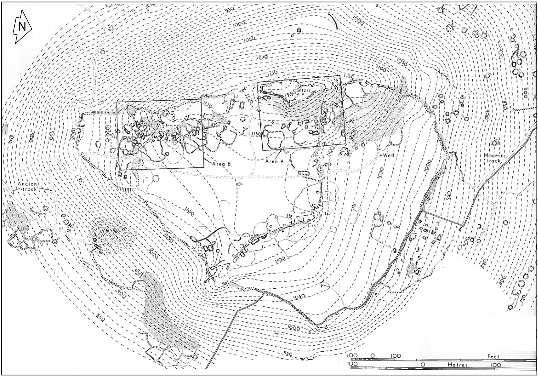
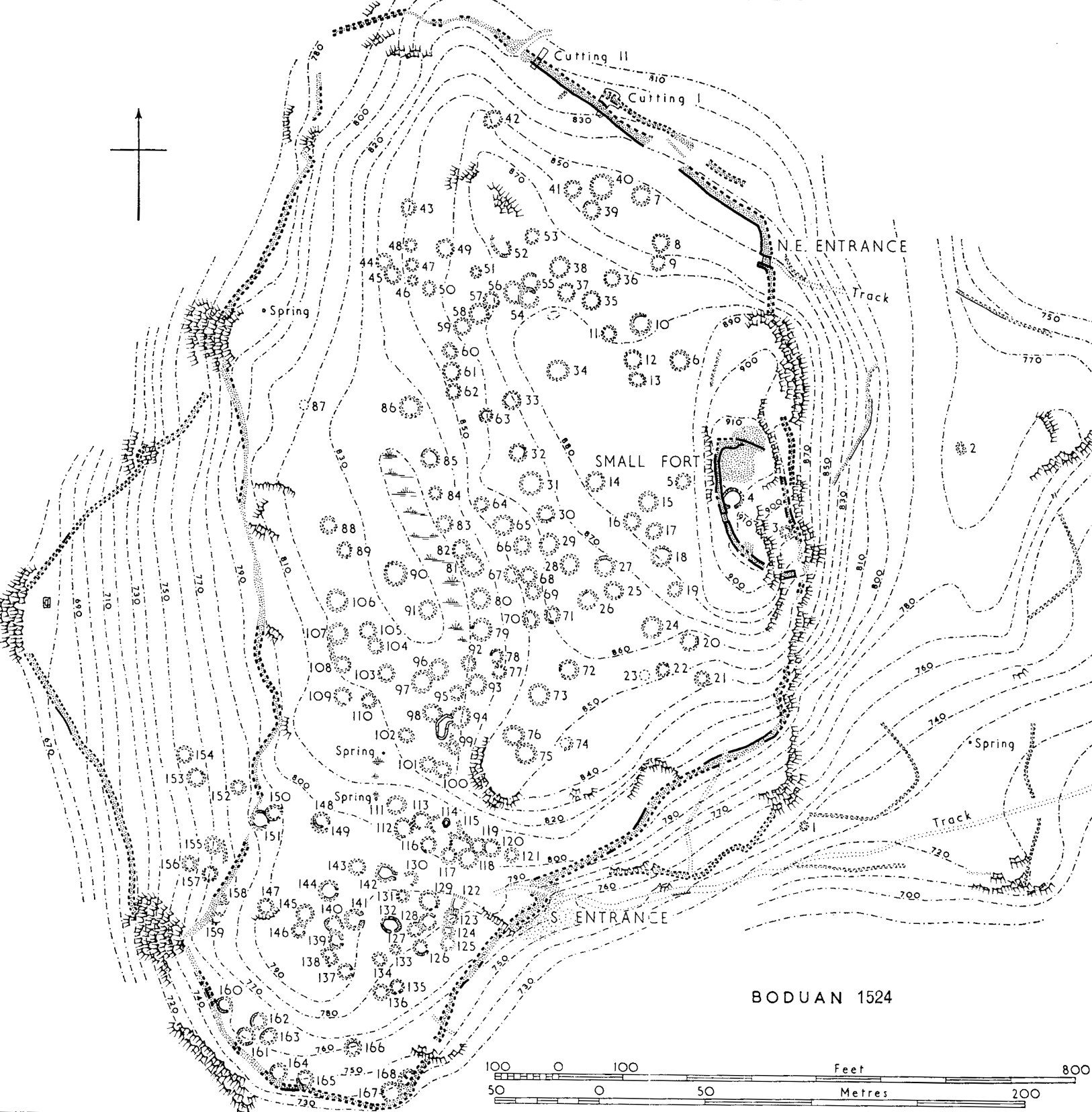
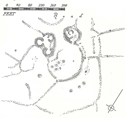
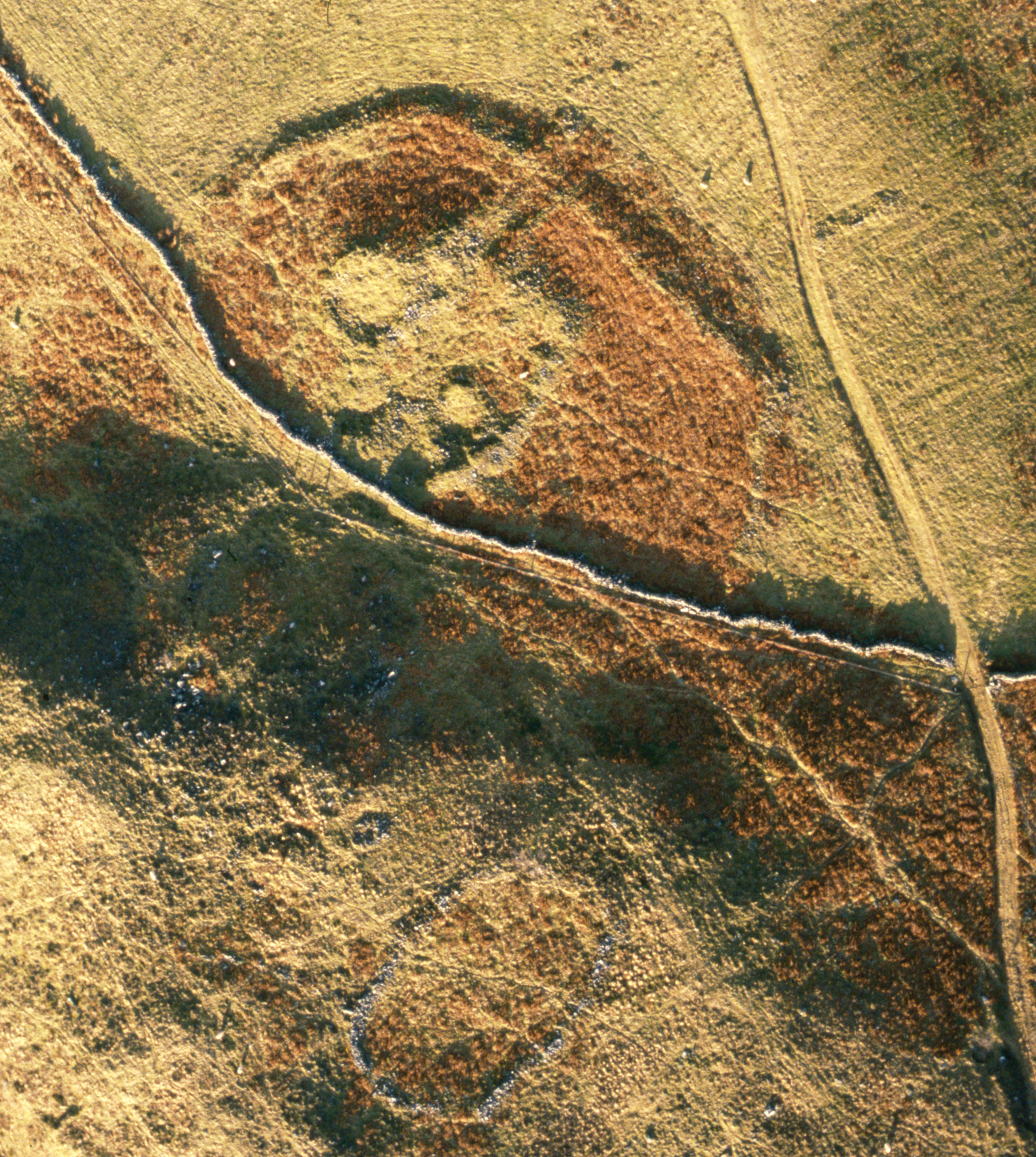
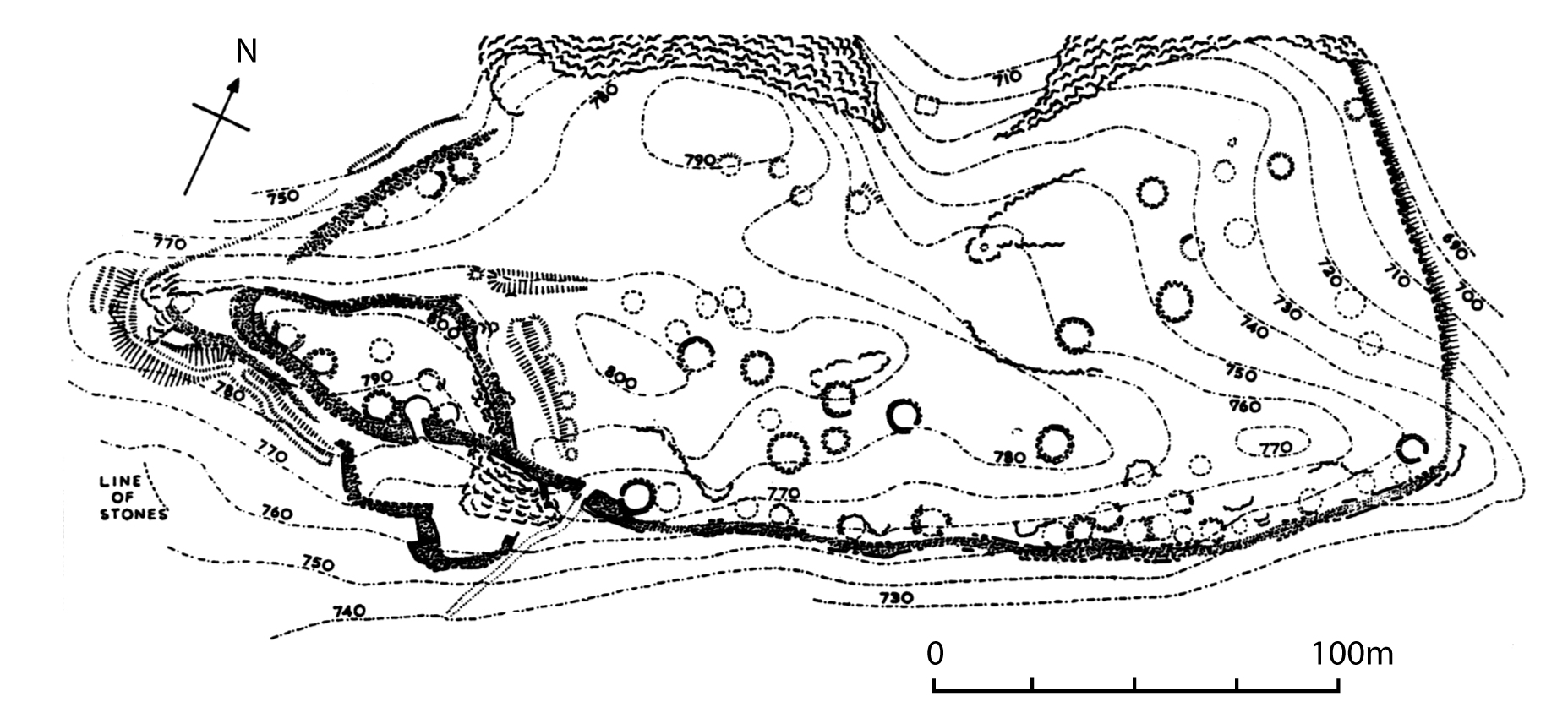
Other curvilinear enclosures exist singly, attached to individual roundhouses or to settlement units of two or more roundhouses. Some form discrete 'courtyards' to the settlement, perhaps acting as 'farmyards' while others, further away from the houses, may well have been 'garden plots' rather than fields. In a few cases similar enclosures occur in or around hillforts; for example there are 17 within the fort at Garn Fadryn (Llŷn), which includes some 50 houses (Figure 25), although some of these may be of Roman or even later date (see below). These again seem to be courtyards associated with individual settlement units (containing more than one hut). There are also 10 other curvilinear enclosures in two conjoined groups on the lower slopes just outside the fort. These have some elements of rectilinearity and were possibly cultivated fields.
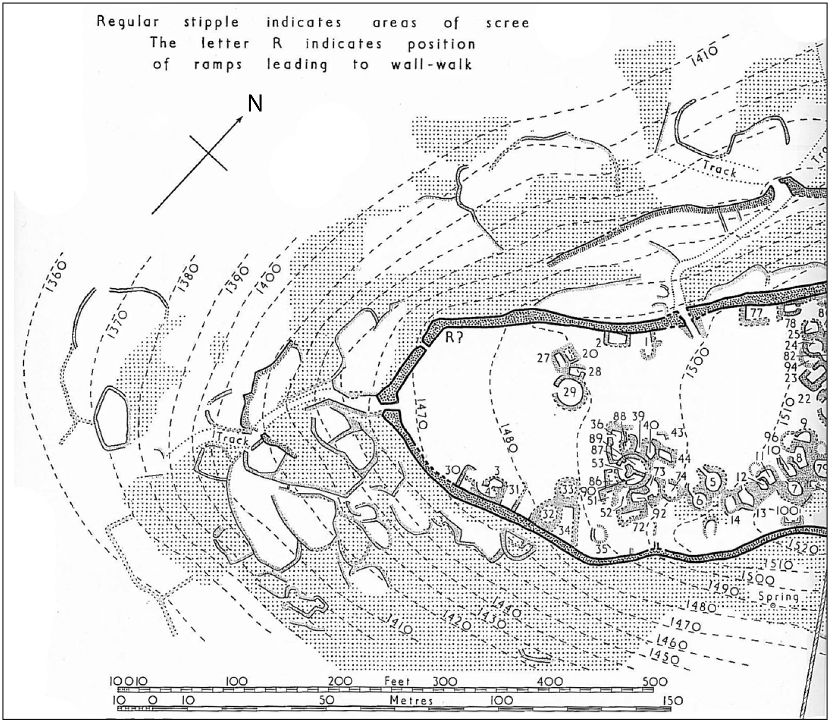
At Tre-r Ceiri small enclosures cluster around the western slope of the hill (Figure 26). The multiplicity of enclosures suggests that each may have belonged to an individual house or settlement unit within the fort. These enclosures are hard to explain because their interiors appear to consist mainly of scree with a thin cover of peat. Unless an original soil cover has completely eroded away, the lack of soil and altitude of the hill (450m) suggests that these would have been used for brief enclosure of stock only, although they have no visible gateways. Another interpretation is that they were milking 'pens' for goats, a form of walled enclosure that was in use in Caernarfonshire in historic times. Comparison of the areas of the curvilinear enclosures with those of rectilinear systems shows that they are generally smaller and of more variable area, reinforcing the notion of a different function (Figure 23). (see Tre'r Ceiri)
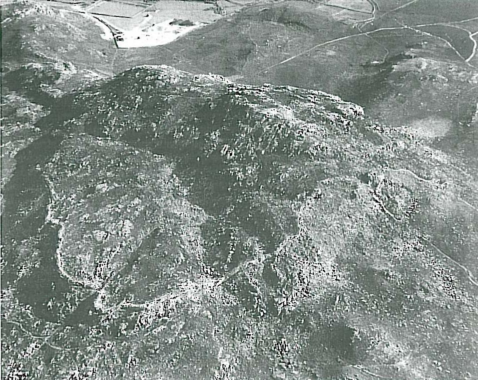
The variety of settlement types found suggests a complex structure of pre-Roman tribal and local divisions. In north-west Wales as a whole, most defended enclosures are small, often simple single-walled enclosures, with 97 under 1.2 ha (3 acres) in area and only 22 larger. Size of fort is not necessarily the best indicator of importance because some smaller forts are very well defended and show evidence of several phases of modification and long use; for example that at Garn Bentyrch, Llŷn (Figure 28). Also, some larger forts were made stronger by a contraction in size in late phases of use, for example at Garn Boduan, Llŷn (Figure 12), and Caer Seion, Conwy (Figure 29). Only a few of the larger forts contain a substantial number of houses or exhibit strongly built or multi-period defences that mark them out as major centres of status and authority and it is these and the smaller strongly defended forts that must be considered as likely candidates to have been territorial centres.
In the medieval period, under the Welsh princes, a system of political administration was established in north-west Wales based on recognised geographical areas. The exact boundaries of these have not been recorded but seem to have been defined largely by existing natural topographic features such as rivers, and more difficult to define 'ancient territories', which may have been re-established after the Roman withdrawal. Some hillforts were occupied throughout the Roman period and so tribal loyalties could have been maintained to some extent. These loyalties would have reasserted themselves after the relinquishment of Roman control, when local authority must have been in dispute. While there is plenty of evidence that some roundhouse settlements were occupied throughout the Roman period, recent excavations have also shown that some continued to be occupied in the post-Roman period. At the settlement of Graeanog, south of Caernarfon, a last use of a hearth there has been dated to 6th-9th century AD (Fasham et al. 1998, 136). At the settlement of Cefn Cwmwd on Anglesey a penannular brooch, an imported intaglio and imported pottery of the 6th-7th century AD have been found (Cuttler et al. 2012). As far as hillforts are concerned, that of Dinas Emrys, in central Snowdonia, has been shown by excavation to have been occupied and of high status in the 5th-6th century AD. Other forts were re-defended, with small castle-like additions at Garn Boduan and Garn Fadryn and others are also suspected to have been occupied at this time, for instance Dinas Dinlle, south of Caernarfon, and Garn Bentyrch (Llŷn).
The names of two hillforts may derive from tribal origins; Din Sylwy and Dinas Dinorwig, the forts of the Silures and Ordovices respectively. However, an alternative derivation for Dinorwig is from the personal name Orwig and most of the forts with specific names derive them from folklore. For instance Din Silwy has an alternative name of Bwrdd Arthur — (King) Arthur's Table (it is vaguely round), Dinas Dinlle — the Fort of Lleu, Dinas Emrys — the Fort of Ambrosius and Caer Helen — the Fort of Elen. Some smaller forts incorporate less obvious personal names that, like Orwig, probably derive from local folklore, such as Caerlan Tibot, Castell Gron, Penarth Gron, Foel Gron, Castell Odo, Garn Fadryn and Bryn Cynan Fawr. The personal name Tibot occurs in some early documents and Gron (Goronwy) is a common name in early Welsh lineages. Odo and the use of 'castell' itself are thought to be post-medieval usages. The name of Garn Boduan is derived from Bod Buan - 'the home of Buan' who is traditionally known as the grandson of the poet Llywarch Hen, indicating a 7th-century date, and the fort has a small inner 'citadel' that may well be of that date. Garn Fadryn also has an inner 'citadel' and this has been identified as the probable stronghold of the sons of Owain at the time the area was visited by Gerald of Wales, at the end of the 12th century (RCAHMW 1964, cxvii-iii).
Whether the later medieval administrative territories of 'cantrefs' (hundreds) or local sub-divisions of 'commotes' had any relation to the tribal areas that existed prior to the Roman conquest is uncertain but the topographic boundaries remained the same and must always have been important. Also, the existence of forts is acknowledged in the names of two of the commotes, those of Dindaethwy (Anglesey), and Dinllaen (Llŷn).
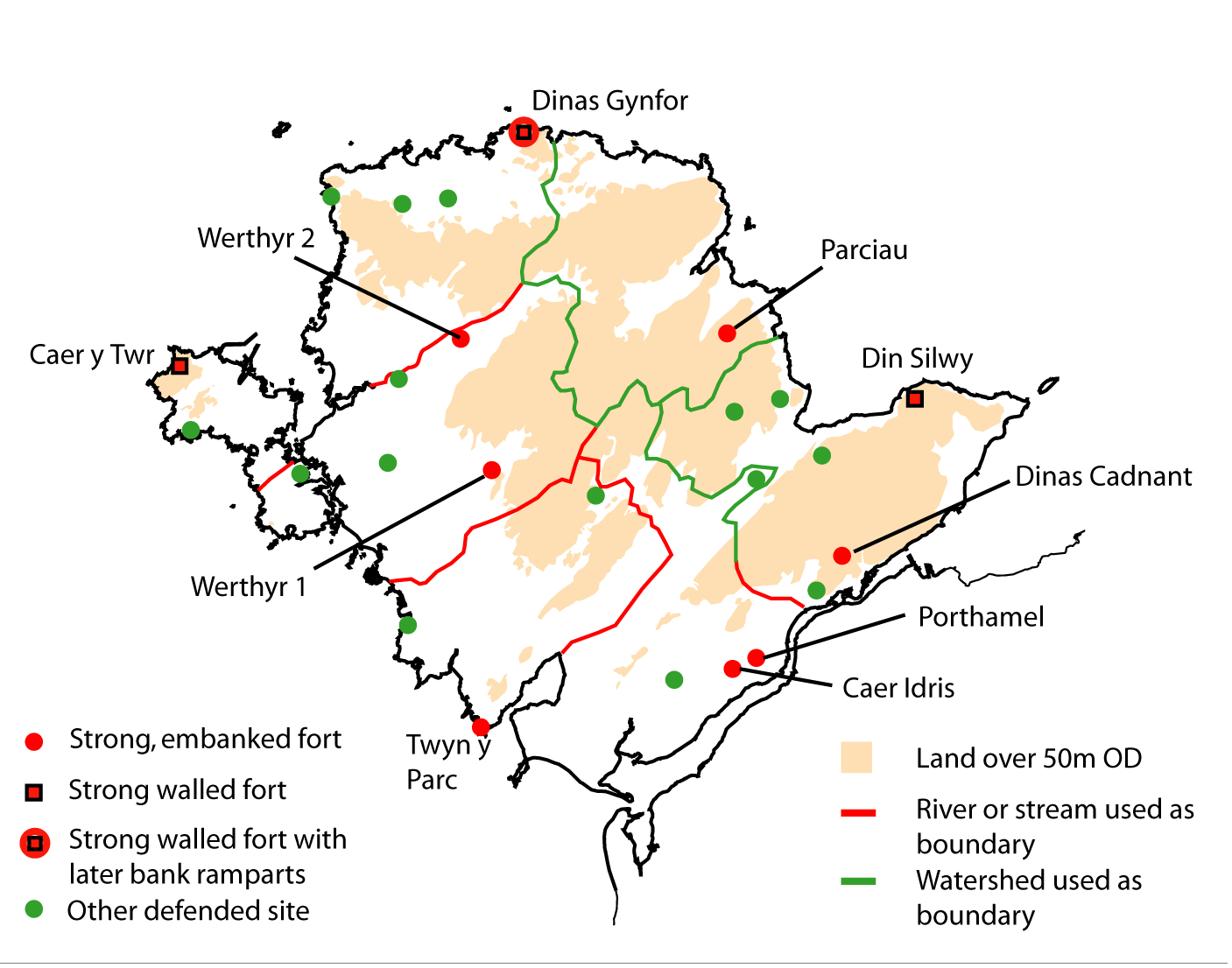
On Anglesey the rivers Cefni and Alaw were important boundaries; the topography and land use is fairly even and the larger hillforts are also widely distributed in a pattern that coincides closely with that of the medieval commotes (Figure 30). On Llŷn the rivers Erch and Soch were used as boundaries in medieval times. The land was mostly lowland but the topography is more varied than Anglesey and forts are more numerous, although most are quite small. Two of the latter have produced querns, providing some evidence of association with arable farming and cereal use but, surprisingly, there are no querns from some larger hillforts despite fairly large-scale excavation, for example at Tre'r Ceiri and Garn Boduan. There is a possibility, then, that their primary economy was based on stock-raising. The fairly even distribution of forts on Anglesey compared to the mainland becomes more understandable when we consider the greater agricultural capability of the land there and the likely reliance upon arable cultivation.
On the mainland, in north Snowdonia and in Meirionnydd, there are several significant rivers that were likely to have marked territorial boundaries but there are also large areas of upland and much greater variations in topography, soils and land use than on Anglesey. The economy in these areas was likely to include elements of both lowland mixed farming and upland pasture, with the valleys acting as important routes to upland pasture. Upland and lowland land usage was therefore probably built into the territorial system and this is reflected in the distribution of forts, which cluster around the edges of the upland. The largest area of lowland around Caernarfon Bay has a natural focus around the fort of Dinas Dinlle. Dinas Dinorwic overlooks the plateau to the north and the entrance to the Peris Valley. The Nantlle Valley has two forts close to its entrance at Caer Engan and Cerrig y Dinas. Pendinas (Llandygai, Bangor) overlooked the entrance to the Ogwen Valley. Smaller valleys to the east are overlooked by small forts at Maes y Gaer (Abergwyngregyn) and Dinas (Llanfairfechan). Braich y Dinas overlooked the whole of the northern coastal plain and Caer Seion overlooked the entrance to the Conwy Valley.
The two forts of Caer Oleu and Pen y Dinas on opposite sides of the Conwy Valley are quite different from each other in style of construction, emphasising the possible cultural dividing role of the river. The land on either side of the valley is different too, as is the distribution of settlements and the river may have marked the western boundary of the tribe known as the Deceanglii. The land on the east side of the valley is mainly improved pasture and has been subject to much clearance. One large bivallate fort there at Cefn Coch (Maenan) has been totally levelled and was only discovered by aerial photography although there is an extremely large fort, Pen-y-Corddyn, a little further east, that could have been a tribal capital. The west side of the Conwy is mainly upland grazing and the area is dominated by the two major forts of Pen y Gaer and Caer Seion, apart from two smaller defended settlements quite close to each other at Cerrig y Dinas, possibly an early lightly defended enclosure, and Caer Bach, a well-defended small ringwork. On the Great Orme promontory (Llandudno), the fort of Pen-y-dinas had little hinterland that could be its territory but it may instead have had a specialised relationship with the copper mines there and with associated coastal trade.
The distribution of defended sites in Meirionnydd is biased towards the western fringe of the upland, overlooking the coast, as with the distribution of undefended domestic settlements (Figure 14), which simply reflects the availability of better quality land there. It is nevertheless surprising that there are large areas of upland where there are no known defended sites, even where there is known to have been considerable undefended settlement. There seems to be a distinction between lowland areas with richer resources that have more focused areas of settlement and areas of upland where there is more scattered, unfocused settlement, and this is a pattern of settlement with a lack of centres of authority, trade or other communal activity not unlike that of today. The exception in Meirionnydd is in the valley of the River Mawddach, which leads through to the upper Conwy Valley and further east, and where several strong hillforts in high positions overlook the valley. Here there is relatively little evidence of actual settlement and it was probably the route itself that was important. This was so in earlier periods, as shown by several finds of stone axes and of bronze weapons, as well as in later periods, as shown by the strong Roman fort at Caer Gai at the west end of Llyn Tegid, near to which the medieval castle of Castell Carndochan was built. If control of routes was important here it may have had a strong influence on the origins of hillforts elsewhere and the position of many at the mouths of valleys has been pointed out. In coastal situations control of harbours may have been similarly important, as pointed out for Pen-y-dinas, Llandudno and as may be cited for some of the coastal promontory forts, such as Dinllaen, Llŷn, and Dinas Gynfor, Anglesey.
Most of north-west Wales has been characterised by small defended homesteads in the Iron Age (Cunliffe 1991, 542) but we have seen that the real situation was one of a mixture of many small with a few larger small forts, some lightly defended, some strong, and this must tell us something about the nature of the society that occupied it. The distinction between smaller and larger strongly defended hillforts may not mean any real difference in function although they do occupy somewhat different areas. Small forts dominate western Llŷn and the area around the Glaslyn estuary. Large forts dominate eastern Llŷn and Anglesey. The suggestion is that in more mountainous landscapes the communities were more diverse with smaller forts, while in more extensive lowland areas the communities were larger with larger forts. The latter social structure matches more closely the situation in the Welsh Borders and central and southern Britain, an area characterised as a 'hillfort-dominated zone' (Cunliffe 1991, 542).
North-west Wales has an exceptionally rich archaeological heritage and none more so than for the Iron Age. The walls of many hillforts, settlement enclosures and roundhouses can still be seen standing as if abandoned quite recently, so the presence of their occupants seems close. Surprisingly though, understanding of the people who created and occupied this landscape has remained distant. In recent years a number of sizeable excavations accompanied by analysis of finds, radiocarbon dating, and palaeobotanical evidence about the environment and of crops has thrown much new light on prehistoric settlement in the north-west. Together with study of hillforts and fields we can now begin to populate this landscape, to outline patterns of territory and power, economy and lifestyle and to recognise its essential cultural continuity, central to which was the Celtic language, from the Dark Age of prehistory into the flowering of the early Welsh kingdoms.
Internet Archaeology is an open access journal based in the Department of Archaeology, University of York. Except where otherwise noted, content from this work may be used under the terms of the Creative Commons Attribution 3.0 (CC BY) Unported licence, which permits unrestricted use, distribution, and reproduction in any medium, provided that attribution to the author(s), the title of the work, the Internet Archaeology journal and the relevant URL/DOI are given.
Terms and Conditions | Legal Statements | Privacy Policy | Cookies Policy | Citing Internet Archaeology
Internet Archaeology content is preserved for the long term with the Archaeology Data Service. Help sustain and support open access publication by donating to our Open Access Archaeology Fund.