Cite this as: Driver, T. 2018 New Perspectives on the Architecture and Function of Welsh Hillforts and Defended Settlements, Internet Archaeology 48. https://doi.org/10.11141/ia.48.4
Hillforts can be extraordinary structures to visit; complex, individual, unusual, or even unexpected. They can also be frustrating to visit; overgrown and enormous, impersonal and exhausting. How do we begin to make some sense of the architectural and engineering achievement of these great monuments, and understand something of their varied roles?
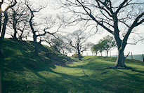
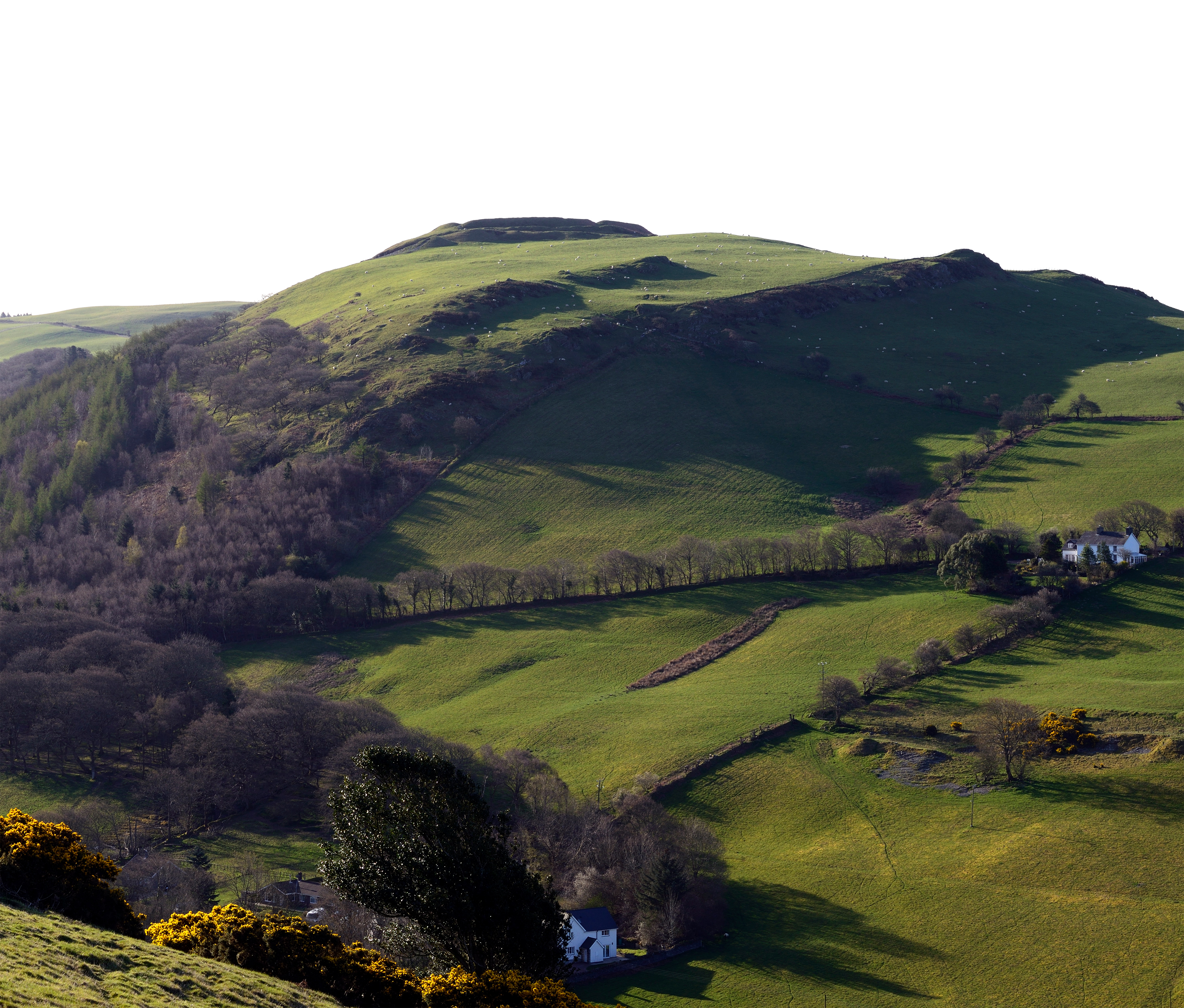
To many, a 'hill'-'fort' is just that; a military building or fortified refuge, conjuring the image of a cowering population building walls and ditches around their village to resist attack. Over the years, the largest and grandest hillforts of Wales — and Britain — have dominated the popular imagination and academic discussion, with a distinct focus on military capability and the size of defences (Figure 1). In terms of architecture, this has frequently been seen as a straightforward response to the threat of attack, first from one's Iron Age neighbours, and later from the Roman army. There are a handful of comprehensive accounts of the principal structures and archaeology of Welsh (and British) hillforts by Savory (1976), Avery (1976; 1993) Hogg (1975), and more recently by Davies and Lynch (2000) and Ralston (2006). Many authors have laboured long and hard on the practical necessities of building strong military defences in order to protect communities in the Iron Age landscape. They tell of successive developments in Roman attack and siege strategy prompting renewed efforts on the part of the Iron Age tribes to further develop their hillfort defences and gateways. But is this really the whole story of the defended settlements of the Welsh Iron Age?
This article will look at changing attitudes to hillfort architecture, and hillforts in general, as a first step to understanding these monuments not as points on a distribution map but as individual buildings - places where prehistoric initiatives and inspiration were put into practice on a vast scale. It will tackle the question of whether these places were military forts, or peaceable farms, or both. It will then look at the complicated, at times odd, nature of some hillforts; not all hillforts and defended enclosures in Wales are built the way we might think they should be. It will look at a case study from Ceredigion in mid-Wales that shows how close examination of hillfort architecture can identify shared design traditions between groups of sites, in turn shedding new light on the organisation of entire regions of the Iron Age landscape. The article will conclude by looking at hillforts in their environs, gaining some sense of the massive impact these buildings made on the Iron Age farming landscape, consuming land, labour and resources.
Hillforts are as varied in scale, appearance and location as the buildings in our present landscape, yet, it would be difficult to describe the common functions of a church, a stately home, an army camp or an upland farm. Similarly we must not forget the great chronological range of these prehistoric buildings. The majority of hillforts in Wales were constructed over at least five centuries, from the middle Iron Age to the Roman conquest of Wales in c. AD 78. Some originated a thousand years before the Romans in the later Bronze Age while others prospered during the Roman occupation, becoming enlarged and developed into Romanised farms. Thus the majority span an equivalent time as from Shakespeare's to the present day, during which changes in our own traditions and ways of life have been astronomical. Frodsham et al. (2007, 250), discussing the hillforts of the northern Cheviots in the Peak District, drew attention to the geographical gulf that can separate hillforts of different regions, and different parts of Britain; 'The hillforts of Wessex and the Cheviots are hundreds of miles, and (in origin) quite possibly hundreds of years, apart'. '… to lump all these sites together as "hillforts" could be likened to classifying Buckingham Palace and an average two-up/two-down terrace in a north-east mining village as "houses" …'.
A.H.A. Hogg once noted 'No archaeologist is satisfied with the term "hill-fort" … if "fort" is understood in the modern sense this is misleading: the enclosures may have corresponded to anything from a cattle kraal to a small town, but were seldom exclusively military' (Hogg 1975, xv). The vocabulary used to describe Iron Age settlements still troubles archaeologists. Describing the Iron Age settlements of the central Welsh Marches, Wigley (2007, 175) argued that very similar Iron Age settlements, with multiple banks and ditches, were described differently depending on how they survived today, whether as an upland earthwork of a lowland cropmark. Thus a 'small multivallate hillfort' in upland or hilly terrain may be indistinguishable from a 'small defended farmstead' surviving as a cropmark on a valley floor. Here terminology is unhelpful, if not spurious, especially if, as Wigley (2007, 186) prefers, Iron Age settlements in general '… occupy a … continuum of enclosure sizes, which extends upwards to include the large hillforts'. Frodsham et al. (2007, 258) noted that any attempt to draw a distinction between hillforts and other earthwork enclosures '… is perhaps misguided' as the monuments display such a range of characteristics as to '… defy ready classification'.
So too in Wales, where it has historically been difficult to get to grips with Welsh hillfort architecture. There are so many hillforts and defended enclosures in Wales, and yet so few have been excavated and dated (see Gwilt 2003; 2007, 298), or even visited by an archaeologist before the recent pan-Wales study, that it has been difficult to advance detailed ideas without giving in to sweeping generalisation. In order to tackle the problem, past studies have approached Iron Age hillforts as exercises in civil engineering and statistics, comparing enclosed areas, numbers of ramparts, their soil volume, spheres of influence and population capacity (e.g. Hogg 1972; Jackson 1999; see Guilbert 1981 for a sceptical viewpoint). Traditional classifications of hillfort architecture identify fairly basic facts and figures; these include simple categorisation of particular elements of the hillfort or enclosure, including its size (usually expressed in hectares), the number of ditches present, from uni- to bi- and multivallate, and the generalised morphology (pear-shaped, rectangular etc.). A further set of very general topographic models is commonly used to classify hillforts, which include the terms 'contour' and 'promontory' forts. Such terms may be useful to gain county- or country-wide overviews and to sort and classify great numbers of sites, but they do little if anything to advance an understanding of the Iron Age in Wales. We have to ask more detailed questions of our hillforts today if we are to move forward. Not 'how many two-hectare contour-forts are there in mid Wales?' but 'why do these three forts share identical gateways?', 'what bearing did the local topography have on the siting of this hillfort?' and 'why does this gateway face towards a mountain pass?'. Classification of Iron Age settlements for the sake of making lists and inventories is of limited use in developing an understanding, but intelligent classification of key architectural features among regional hillforts may actually provide a better understanding of how Iron Age communities developed and shared their ideas for building.
[Hillforts] are the products of peace and not of war and I would disabuse the minds of those prone to imagine scenes of battle and strife, wherever and whenever they see the remains of the homes of the people of long ago. I, however, do not want anyone to believe that the old Celt was remarkable for his peace-loving character; no one loved a scrap more than he' (Evans 1933, 20).
It is generally understood that the development of strongly defended settlements and hillforts, which began in the later Bronze Age but achieved their maximum numbers during the 6th and 5th centuries BC, the Early Iron Age, followed by increasing complexity during the 4th to the 2nd centuries BC, the Middle Iron Age, was linked to a growing complexity and ostentation of the defences and gateways. Developing ostentation was often on a scale that exceeded basic requirements for defence, suggesting instead a symbolic role for some more imposing ramparts, perhaps to reinforce the status of the inhabitants. More recently such symbolic display and ostentation has been described under the term monumentality (Mytum 1996; Hamilton and Manley 2001).
Were these developments in defensive complexity linked to a more aggressive military role? Were forts specifically designed to repel attacks or were the defences intended more for symbolic purposes? It seems likely that the two were in fact inseparable. The Roman historian Tacitus described Agricola's battle of Mons Graupius, late in AD 84, on the approaches to Inverness thus:
'The [Roman] troops were mad for action and ready to rush into it, but Agricola marshalled them with care … The British army was stationed on higher ground in a manner calculated to impress and intimidate its enemy … the other ranks rose, as it were in tiers, up the gentle slope. The space between the two armies was taken up by the charioteers …' (Mattingly 1948, 85-6).
As Tacitus describes, the need to impress and intimidate an enemy is perhaps as much a part of conflict as the physical battle itself.
The idea of hillforts as military strongholds was underlined by the publication of an influential paper by Christopher Hawkes in 1931, together with a developing profile for major excavations. Chief among these were Sir Mortimer Wheeler's campaigns at Maiden Castle between 1934-7, undertaken on an unparalleled scale, which famously unearthed a 'war cemetery' of Iron Age skeletons, interpreted by Wheeler as evidence for a bloody attack on the inhabitants by the Romans (see Sharples 1991, 124-5, for a more recent interpretation of the evidence). Hawkes introduced the idea, now superseded, that hillforts were built by invading immigrants to Britain, and he proposed that the earliest were constructed in southern England close to the Channel crossing, with later hillforts spreading out to the rest of England and Wales. Much of this thinking may have developed from the spectre of contemporary events, and the ever-present threat of invasion in the inter-war years. As Wheeler wrote in 1956 (16-18), describing his work on hillforts,
'We belong, some of us, to a generation which has been involved actively in two wars. Military similes are therefore not entirely alien to us … Our hill-forts … demand the virile spark of the mind militant'.
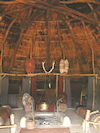
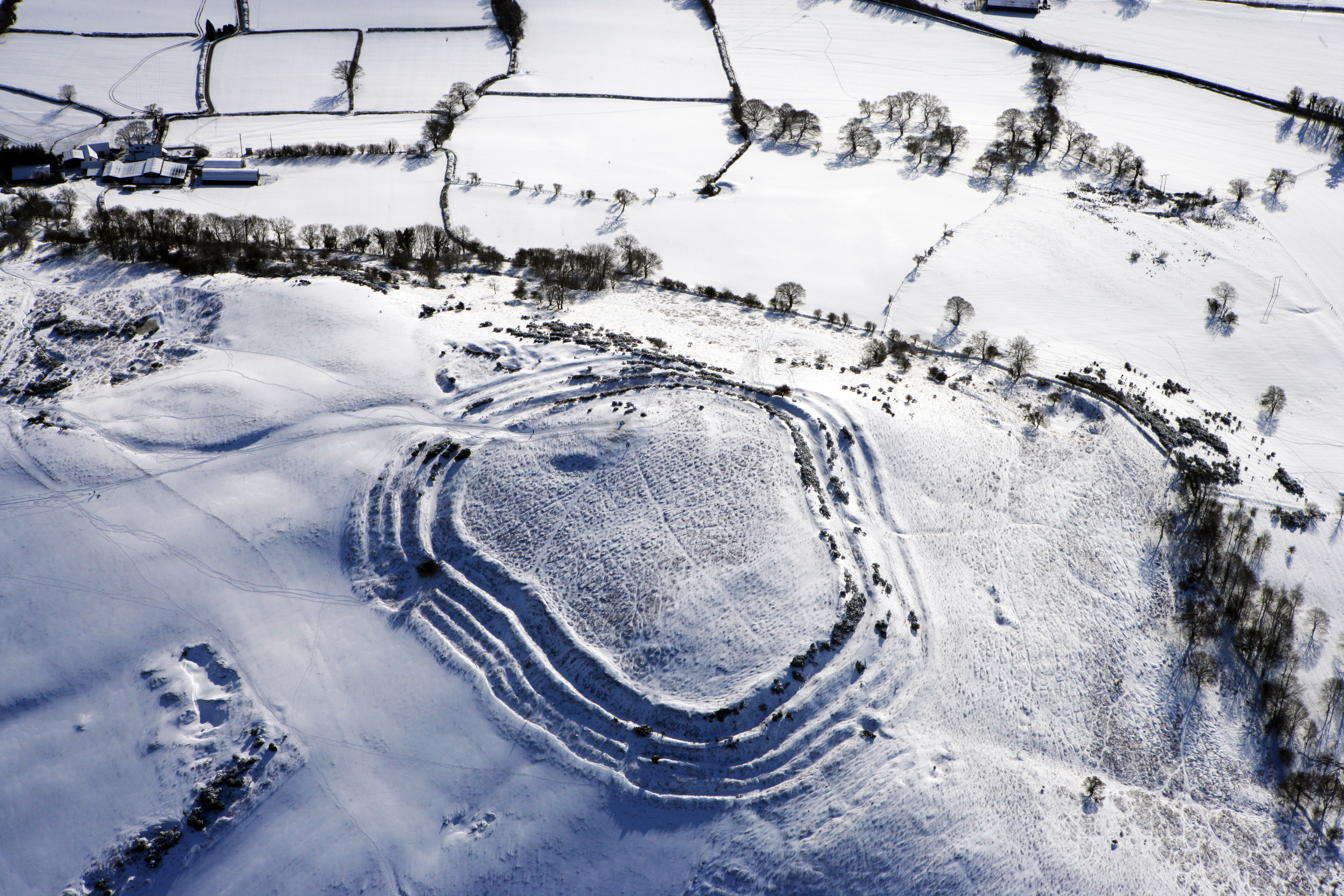
From the outset, Avery (1993, 2.1, 6) considered hillforts to have been strategic machines built to repel attack, with the 'hillfort engineer' judging his tactical aims for the hillfort against the type of attack he would encounter, whether close combat or missile warfare. He noted (1993, 2.10, 8) that 'The ramparts and entrances of hillforts were responses to three methods of attack: close combat attack; missile attack; and attack by fire'. Avery further stipulated (1993, 3.1, 10) that ramparts served two purposes: to repel attack, and to be well built within the principles of soil engineering. These themes remain in favour. In a study of the Black Mountains, Olding (2000, 56) supported a thesis of a threat of Roman incursions by noting that '… the fact that all the known Iron Age settlements in the eastern Black Mountains are fairly strongly defended suggests that the risk of attack was always present'. It is true to say that a few of the Borderlands hillforts have revealed good evidence of what might be Roman attacks, which can even be linked to specific Roman campaigns in the early years of the conquest of western Britain (Manning 2001). However, we cannot pre-suppose that all impressive or 'strongly defended' hillforts were actually engineered in this way to fulfil a military role (see Figure 2).
Collis (1996, 87-9) noted that display and ostentation were important factors in the defence of a fort, with the defences of Maiden Castle, Dorset, acting as '… a very strong demonstration of force to outsiders'. The point was best made by Hogg (1975, 49) who noted that a terrifying façade easily fulfilled a military role, for '… ideally a fortress should be so strong as to make any thought of attack appear hopeless'. Savory reinforced this coincidence of display and strength by noting the political importance of the hillfort gateway. 'The enduring nature of the authority under which hillforts in the Marches were constructed, at least in the early period, and its wide scope, are above all proclaimed by their entrance features …' (Savory 1976, 264). More recently, Hill, among others, has extensively examined the non-defensive nature of hillforts (1995, 52-53).
The military role of hillforts is not a theme that can simply be accepted or rejected by concluding that hillforts that may have been difficult to defend when judged by modern military or functional criteria could never have been used as defensible sites. In an influential paper, Bowden and McOmish (1989) suggested that hillforts with highly visible interiors, overlooked from surrounding higher ground, were untenable as military strongholds, and perhaps had alternative, ceremonial roles. Avery (1993, 2.21, 8) noted that a functional hillfort rampart should be high enough to obscure the view of the interior, allowing the inhabitants the advantage of '… interior lines of communication' against their assailants. The argument regarding visibility of the interior is a problem when we consider many Welsh hillforts. Where the forts enclose prominent, elevated ridges like the Clwydian hillforts, or enclose sloping sites, like Caer Drewyn, Corwen, interiors can either be fully overlooked from nearby high ground or readily looked into from surrounding approaches. Are we to consider all these hillforts to have been unusable as defensible enclosures? When we look at information from the individual hillforts there are problems; many were heavily defended with well-designed gateway systems, with clear 'command posts' and putative slinging platforms commanding the field of approach. The sling, made famous in the story of David and Goliath, was the common weapon of the Iron Age, comprising a length of leather and small rounded beach or river pebbles for ammunition. In experienced hands they were accurate and deadly, with a range of between 60-100m. Traces of sling-stone caches have been recovered from many Welsh hillforts, with a cache of some 5000 sling-stones excavated at Castell Henllys (Mytum 2013).
A belief that all 'hillforts' were functional military strongholds is difficult to support when considering a range of monuments in Wales. Oddities are seen in the defences of small to medium sized hillforts; there are massive ramparts — in places — but also great gaps in the perimeter defences; there are strong defences built on naturally strong slopes but none to block more gentle approaches. The oddities of Welsh hillfort architecture go beyond the sober buildings of prehistoric people obsessed with protection and attack strategy. They speak of monumental symbolism and display, neighbourhood one-upmanship and the conjuring of fear, terror and respect in the minds of one's enemies — and friends — as they approach the hillfort.
'As to the purpose of hill-camps, we can but say that many of them still testify to the unerring choice of site and amazing skill with which their defences were conceived and carried out …' (Hughes 1933)
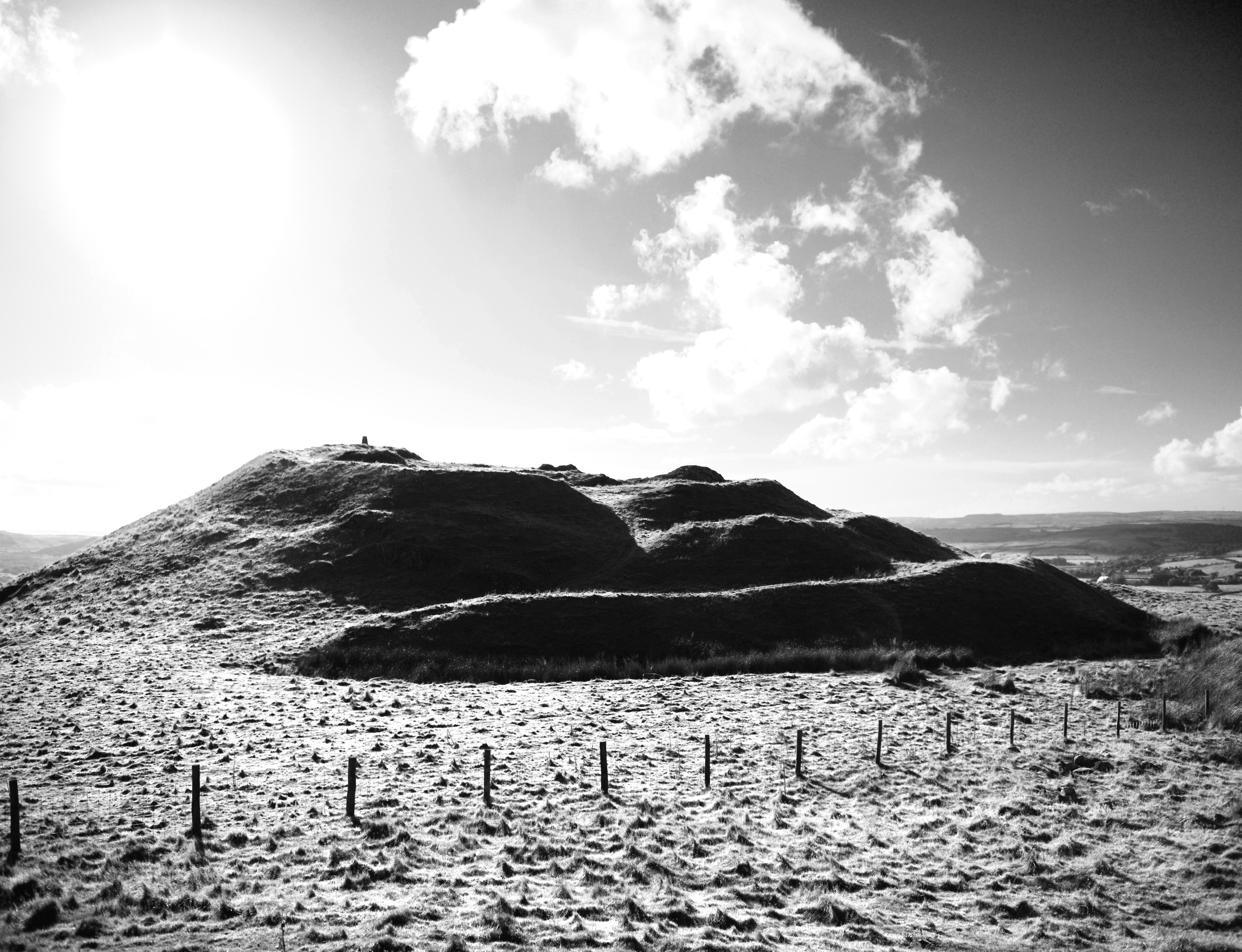
Some authors writing about the Iron Age tend to look only at the largest and most impressive hillforts in Britain. While there is nothing wrong in this, it can lead to a skewed perspective. Michael Avery (1993) compiled a seminal three-volume work on hillfort defences in southern Britain, which remains the most comprehensive of its type in the 20th century. It is nothing short of an exhaustive engineering and tactical manual for hillfort construction. However, the sample of 150 excavated hillforts on which it draws (1993, 1.16, 4) are predominantly the 'ideal' British hillforts, these being the largest, most impressive and most heavily defended examples, such as Old Oswestry, Herefordshire Beacon, Maiden Castle. These are the pinnacles of Iron Age achievement in Britain, planned and completed on all sides by an abundant — or at least sufficient — workforce over many years. Actually, these hillforts remain the exception, rather than the rule, in a regional Welsh landscape of, at times, oddly designed and apparently unfinished small hillforts.
Some of the largest Welsh hillforts are complete on all sides, built by a competent and sufficient workforce, and represent the pinnacle of the hillfort-builder's art (Figure 3). These forts cannot fail to impress today, and they teach us that middle to late Iron Age architects often valued steep, large, multivallate defences both for practical protection as well as to inspire fear and awe in their friends and enemies. More instructive for the study of Iron Age architecture are those sites that are not complete on all sides and are only finished in the places that counted. Whether through the restrictions of a lesser workforce, a building project plagued by intermittent phases of occupation and development or — as is equally likely — an overriding desire to project architectural symbolism in a particular direction, some fort defences are curiously one-sided. One side of the fort may be terraced, developed and hugely altered over generations; the other left as a natural slope. At times this can be explained by the existence of a steep natural slope requiring little augmentation with artificial defences; at others a deliberate choice has been made to defend only one part of the complete hillfort circuit.
| FRONT | REAR |
|---|---|
| Monumental architecture | Utilitarian building |
| Façade | Rampart |
| Visible | Invisible |
| Symbolic | Not symbolic |
| Artificial/contrived | Natural/unremarkable |
| Formal | Informal |
| Public | Private |
| Main gateway | Postern/rear or no gate |
| Most Effort | Least effort |
| Structure | No structure |
| Closed/blocked | Unenclosed/open |
| Defensible | Indefensible |
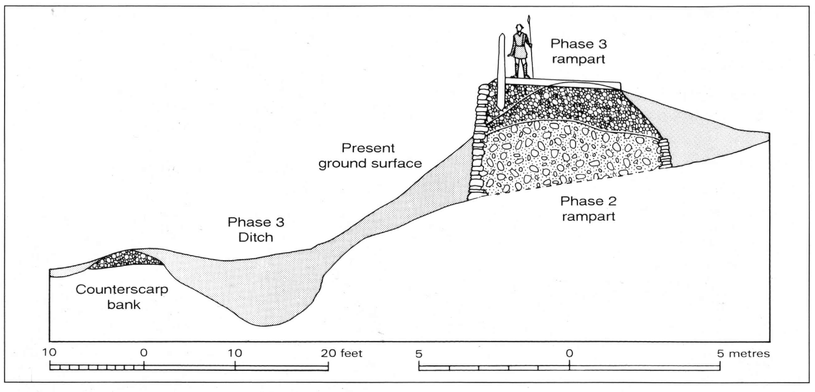
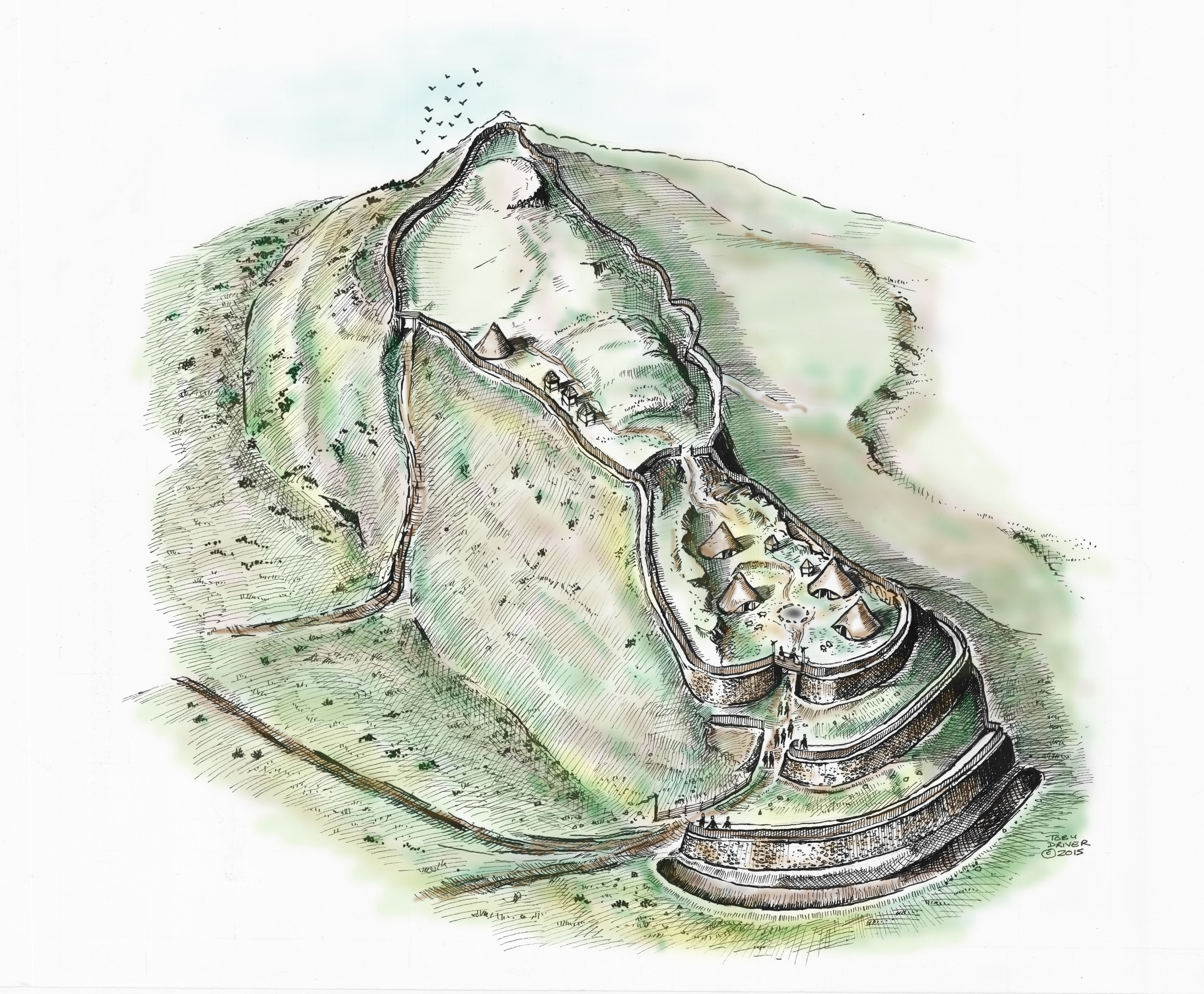
There is merit in looking at smaller, regional Iron Age hillforts in Wales to develop a clearer understanding of prehistoric architecture and monumentality. At these smaller hillforts, where labour may have been limited, leaderships strained and priorities sharply defined against the other demands of the social and farming year, we may be all the more surprised to see a considerable investment of communal labour in monumental architecture. The resulting hillfort also becomes an achievement of enormous significance to the community building it, and an iconic monument in the surrounding landscape. At these smaller hillforts, ramparts may not have been completed on all sides. Here, duality played an essential part in their construction, this being the treatment of the 'front' and 'rear' of the fort in quite different ways. With the recognition of a public front and a private interior and rear, important, highly symbolic parts of the hillfort like the main gateway may have seen a heavy investment of design and labour at the expense of less crucial parts of the fort, which may have been only lightly enclosed with a low rampart or wattle fence or left entirely undefended. At Castell Henllys (Mytum 2013, 305) the elaborate, heavily guarded and much modified main gate contrasted with the '… many breaks in the perimeter earthworks [which were] … never blocked or controlled by gates'. Such arrangements rendered many hillforts impractical in military terms, whereby invaders could literally step over or walk through flimsy rear defences, yet at the same time they were incredibly well defended by giving an effective impression of military might (Figure 4; Table 1).
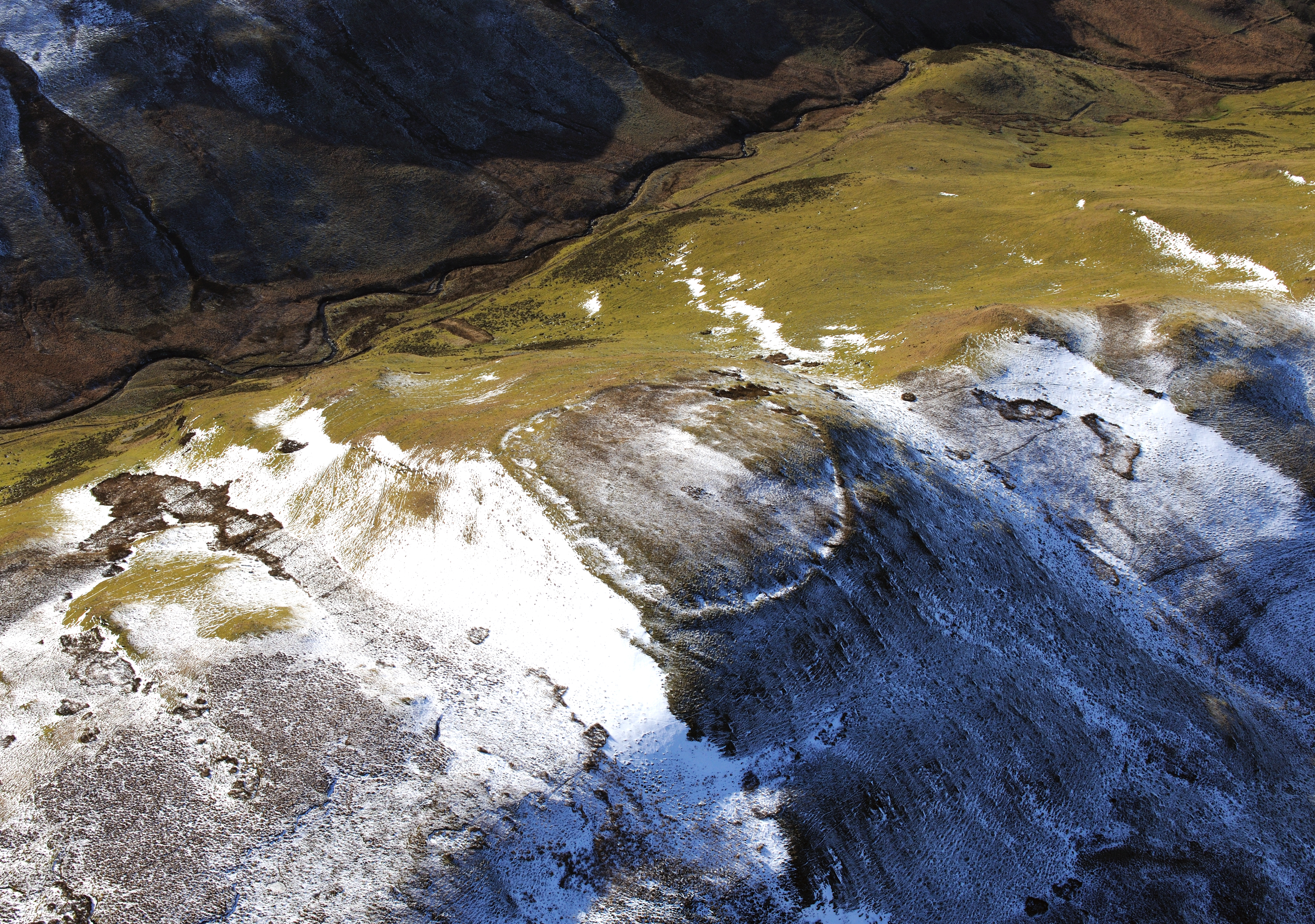
When studying the Peak District hillforts, like St Gregory's Hill, Frodsham et al. (2007, 254) found no correlation between the variable size of the ramparts and the defensive strength, or weakness, of the natural slopes around the fort. Indeed, the defences were sometimes higher where the natural slope was steepest, yet weak where slopes were not similarly reinforced. The same was true at Mid Hill fort, where the English Heritage investigators (Oswald and McOmish 2002, 23) found that the weakest slopes around the fort including strategic 'blind spots', were defended with ramparts of 'negligible height', whereas the easiest natural approach to the fort and its entrance was completed with massive ramparts. They noted 'the inescapable conclusion is that the function of the rampart was more about impressing the approaching visitor than about defending against a well-planned or prolonged attack' (Oswald and McOmish 2002, 23; Figure 5).
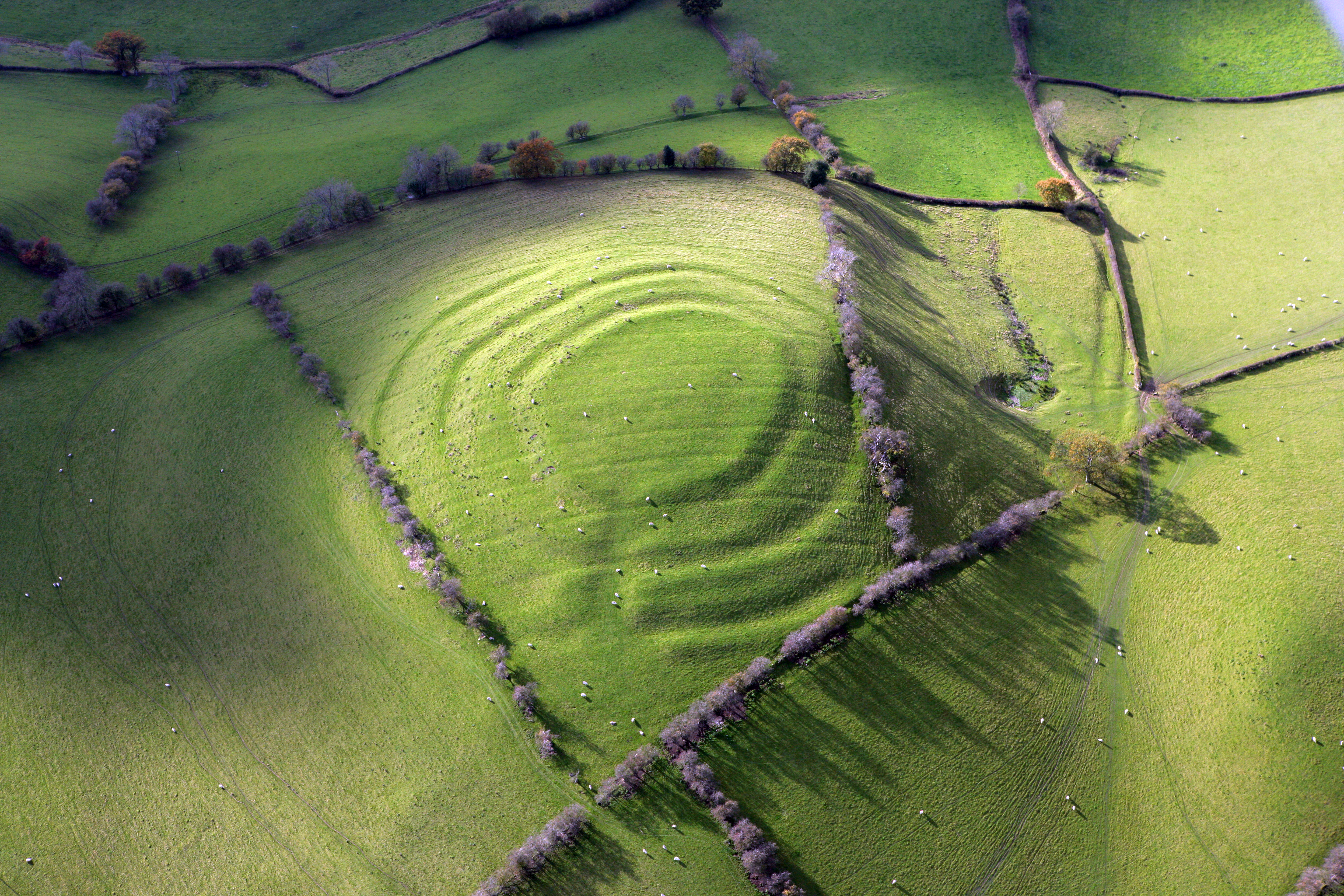
Crowning a rounded hillock in undulating country south-west of the Vale of Meifod is one of the hidden wonders of the Welsh Iron Age (Figure 6). Pentre Camp exemplifies the enormous importance Iron Age people must have attached to architecture and design when first setting out, then building, their hillforts. The defences were expertly planned with four concentric ramparts, an arrangement difficult to parallel in other parts of central Wales, although multivallate sites are common. These are not straightforward: both innermost and outermost ramparts are conventional banks, but the intermediate defences are flat interspaces defined by ditches. As well as the main concentric ramparts, there are traces of discontinuous, more denuded, ramparts on the south and west sides, suggesting more than one phase of development. Whether they ever stood very high is uncertain; it is possible that these low banks provided firm foundations for concentric timber defences. A significant aspect of the site's setting is the prominent spring below the fort to the north (Figure 6, centre-right). This deep enlarged spring, which is backed by a rocky slope and still issues water, sits immediately at the base of the precipitous slopes that fall from the north side of the hillfort. Whether the spring had any symbolic role in the life of the hillfort, or was even the reason why such an extraordinary fort was built here, is more speculative.
Well-executed circular forts are found across Wales; along the Teifi valley in Ceredigion at sites like Pen-coed Foel hillfort at Llandysul (NPRN 92243; see Cadw 2008, 6), a univallate circular fort occupying the rounded summit of a prominent hill, Pen-y-Gaer at Llanybydder (NPRN 303873), a univallate circular hillfort again on a rounded summit, but with an impressive outwork flanking the north-east side giving an impression of multivallation looking up along the Teifi corridor, and even perhaps Castell Nadolig near Penbryn (NPRN 304136), an unusual concentric hillfort with very wide-spaced outer ramparts that occupies a prominent, low summit on the undulating coastal plain to the east of Aberporth. The unique place-name at this latter site, 'Christmas castle', loosely implies a seasonal significance to the site while antiquarian finds of a pair of 'divination spoons', one of only 15 pairs recorded from the British Isles (Fitzpatrick 2007), and probable Iron Age cremation burials, show a focus of important ceremony and ritual here and the likely presence of a religious elite (Fitzpatrick 2007, 298). Recent fieldwork by the author identified a large rock-cut spring within the hillfort that may have been significant in the Iron Age (Driver 2016).
Whether careful circularity in hillfort-building was an architectural or ceremonial statement, or whether it drew instead upon more functional pastoral origins of the 'concentric antenna' corral-type enclosures found throughout south and west Wales, thought to marry inner settlements with concentric in-fields or paddocks, is uncertain.
There were major differences in the way the monumental architecture was made 'visible' or 'invisible' by different communities of 'hillfort-builders'. It may seem obvious that a community investing heavily in a prestige building project, incorporating cutting-edge architecture, would want to 'show it off', and that a hillfort with a role to command, or control, a population or an area of territory, would need to be highly visible. The 'intervisibility' of all manner of prehistoric monuments is, after all, a common discourse driven by a basic premise that prehistoric people wanted their monuments to be visible. Hogg (1975, 53) questioned the early 20th-century trend to highlight the intervisibility of hillforts by noting '… but hill tops can usually be seen from other hill tops'. However, from what has been learnt about hillforts we can now appreciate that approaches to monumental architecture were more complex than simply building a 'big fort' on a 'big hill'.
Many hillforts occupy highly conspicuous locations, either heightening their visibility with extensive artificial defences or 'borrowing' the pre-existing natural strength and visibility of a commanding outcrop to make their mark. In these cases it is difficult not to argue that the hillfort-builders saw visibility, and visual command of the surrounding landscape, as important both politically and culturally. For the Atlantic roundhouses or brochs of western Scotland, Armit (1997, 249-50) described the consistent selection of highly dominant settings, on highly visible sites, as an attempt to imprint the household on the landscape. He wrote:
'It served as a symbol to outsiders of the control of the household over the surrounding land … their centrality within the landscape which supported them, and of their isolation and independence from other households.' (Armit 1997, 250).
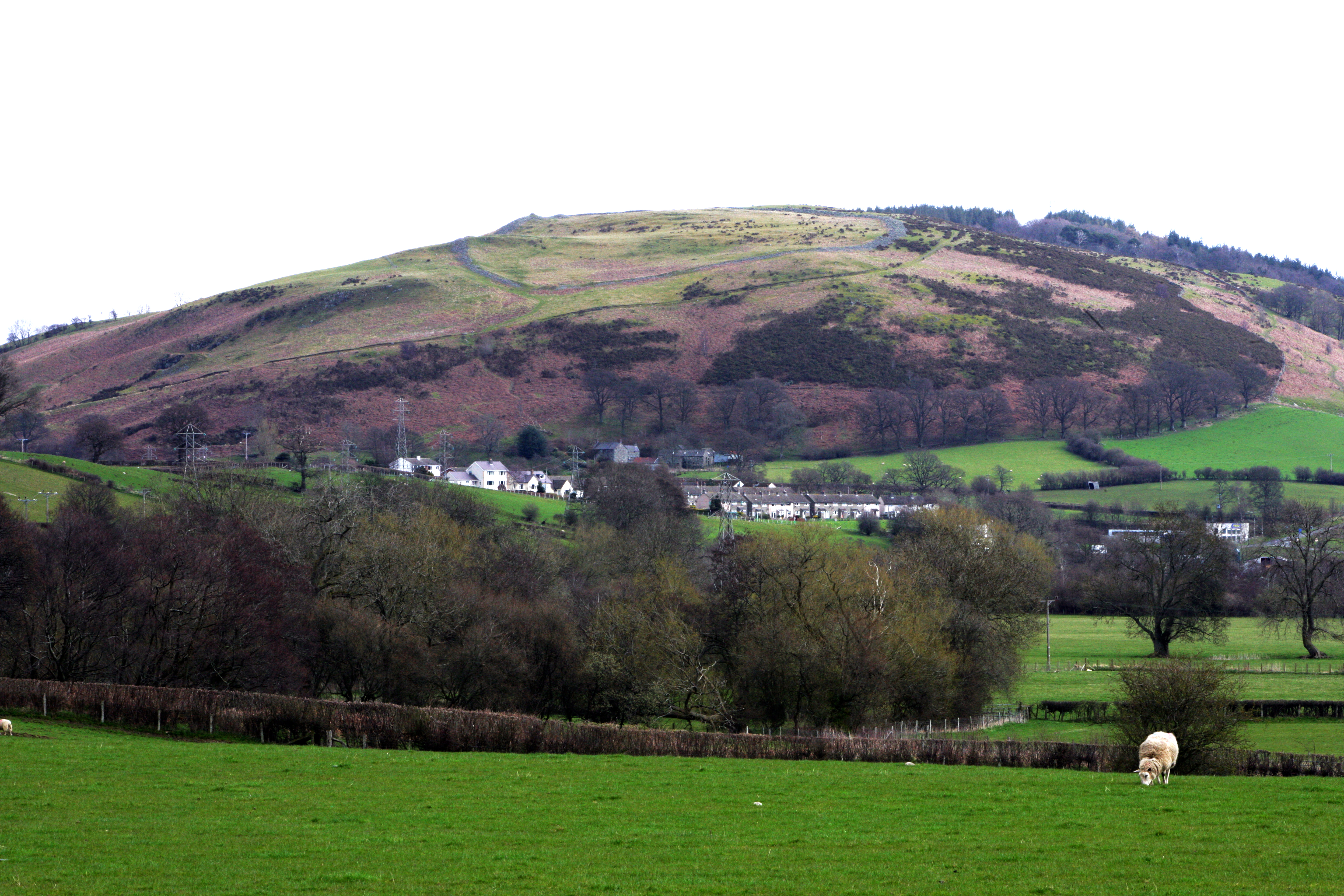
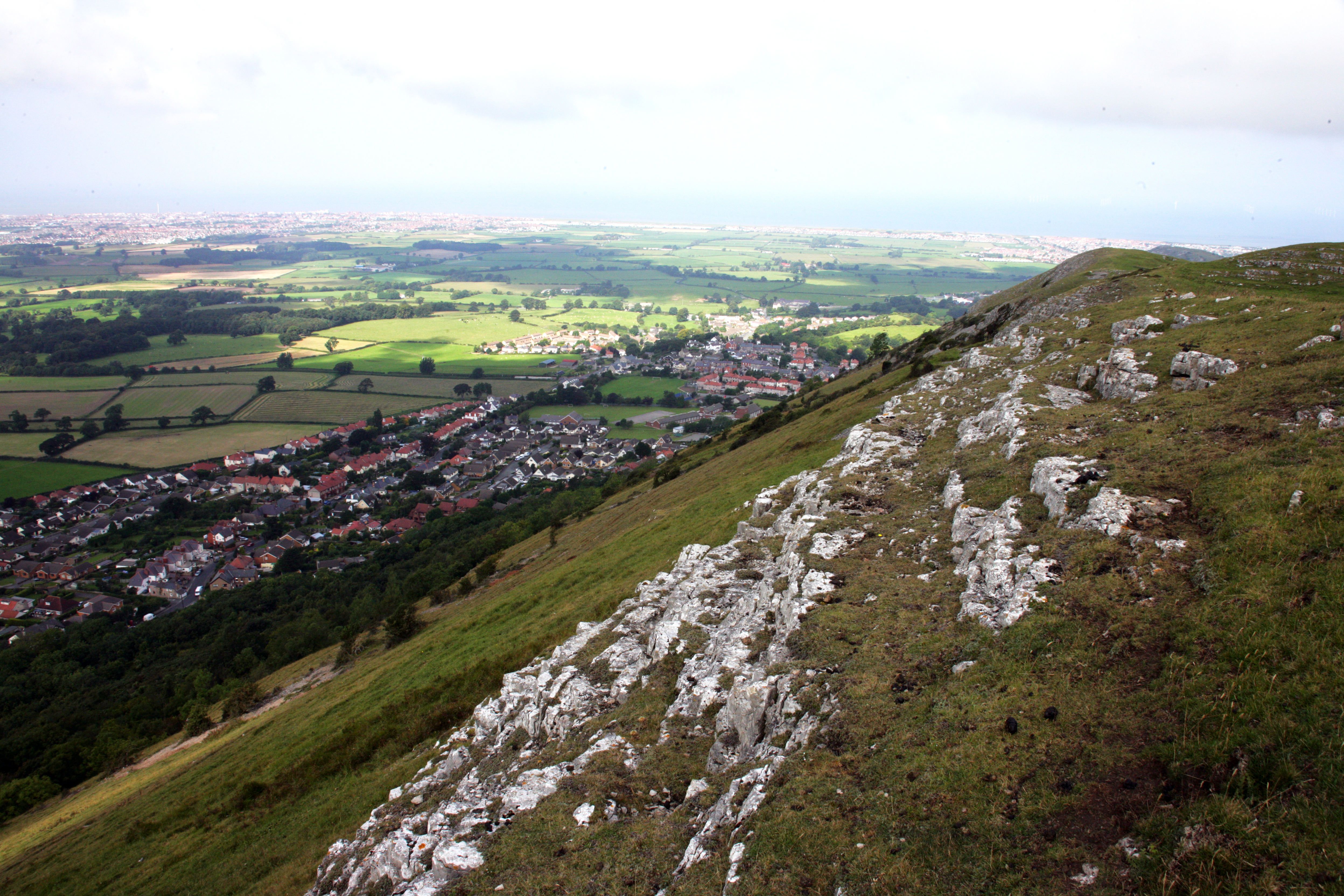
Similar findings about the conspicuous nature of hillforts, or a choice of setting or positioning to heighten visibility from valleys below (as at West Hill, Oswald et al. 2000), have been described following recent surveys at some Northumberland hillforts like Great Hetha (Pearson and Lax 2001). There are considerable differences between those hillforts built in conspicuous locations with long anticipatory approaches (Hamilton and Manley 1997; 2001), seemingly designed to form enduring and obvious monuments in the landscape, and others, built in more local settings and 'encountered' in the context of more immediate approaches. Some of these were built along inconspicuous valleys, but an equal number were sited close to commanding ridges or summits but nonetheless avoided them, apparently by design. A prime example is Caer Drewyn, Corwen, a substantial hillfort in north-east Wales, which avoids a summit in favour of enclosing a steep hillslope below. Willoughby Gardner first drew attention to its peculiar setting in his presidential address to the Cambrian Archaeological Association, where he noted; 'Caer Drewyn … lies, curiously, down the slope of the hill, at an altitude from 980 ft down to 825 ft …' (Gardner 1926, 236). Conventional wisdom dictates that a 'hillfort' which can be looked into or overlooked can not have served an effective military role (see above). However, the Iron Age was full of contradictions; what if the visible scale of the fighting force within the fort, or signs of preparations and readiness for attack, were enough to warn off an invading force as it approached across the lowlands? Caer Drewyn no doubt drew strength from its position, on a prominent spur jutting into, and looking out across, a major valley junction of the Afon Alwen and River Dee (Figure 7). Thus it commanded the confluence of several major valleys, a strength shared by other Welsh forts like Cefncarnedd, Caersws, in the Upper Severn Valley. These themes are further explored below.
'Hillforts' that defy conventional wisdom can be found wherever one looks in the regions of Wales. The large hillfort at Hen Gaer, Penrhyncoch, avoids a summit position and is built to enclose a steep hillslope, 'half on and half off' the ridge top (Driver 2008; 2013). The interior slopes at an angle so steep that building a level roundhouse would be extremely difficult. Close by is level ground on the summit of the ridge, but this was deliberately avoided. In this respect it is similar to Caer Drewyn, and also the well-studied Peak District hillfort of West Hill, a complex, long-lived circular fort that nonetheless 'tilts' to the north (Frodsham et al. 2007). One conclusion that can be reached about forts which tilt to overlook a valley, pass or approach is that it enabled the hillfort-dwellers to maintain visual control over a given territory while allowing the fort and its occupants to visually dominate the approaches.
How do we start to look again at hillforts in the landscape? Why should two or more Iron Age hillforts have been built in very similar ways, with a similar layout of their ramparts and gateways and similar approaches? Why may two of their close neighbours be very different, tackling the enclosure, defence and approach of a similar hilltop in very different ways? What do these observations tell us? Was each fort an entirely 'new build', the result of 'independent invention' by a small farming community plucking ideas for defence and design from thin air? Or, as is more likely, did each builder embarking on the construction of a hillfort strive to draw on a pool of existing knowledge and experience, perhaps following prevailing traditions, emulating the designs of neighbouring and farther-reaching fortresses or indeed carefully referencing the key elements of the great regional forts in an effort to build alliances and share in networks of protection and respect (Driver 2016, 76-7)?
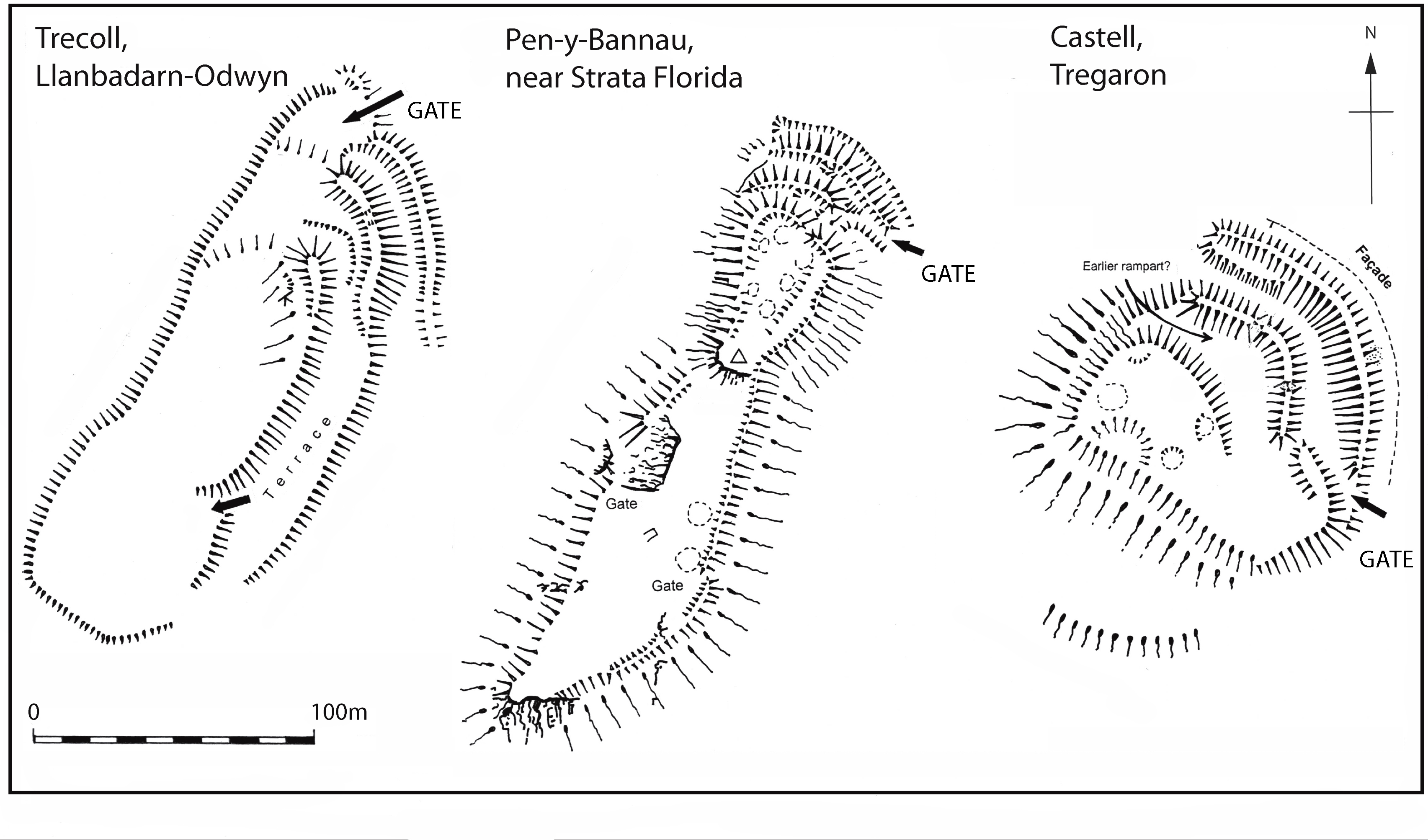
Following a study of hillfort architecture in north Ceredigion by the author (Driver 2013; 2016), shared architectural traditions for the construction of some regional hillforts were revealed that guided the way ramparts and ditches were arranged, and how the fort would finally appear. Particularly surprising was the realisation that some hillforts had been built to conform to a distinct architectural tradition, regardless of the constraints of topography (Figure 8).
A starting point was to try to understand why several hillforts in a region could be built in a very similar way, while other neighbouring forts were radically different. These similarities and differences extended even to basic arrangements, such as how one approached a gateway. At some forts the gateway opened straight onto the approaching hillslope, with no outworks, annexe or blocking ramparts of any kind. Other gateways lay hidden by multiple overlapping ramparts, or obscured behind massive, sweeping entrance defences, and had to be 'sought out' by visitors. Such fundamental differences in the visibility and protection of the main gate, when coupled with a study of the wider layout of the hillfort, began to allow regional hillforts to be parcelled up on architectural grounds; this process assumed some cultural cohesion, and broad chronological homogeneity, between very similar forts. Clear sets of architectural 'building blocks' were found among forts that occupied different topographic settings including narrow or broad ridges, knolls and outcrops. Two main architectural traditions were identified; the Pen Dinas and the Cors Caron traditions. When the patterns were examined across the regional landscape, a startling pattern was revealed.
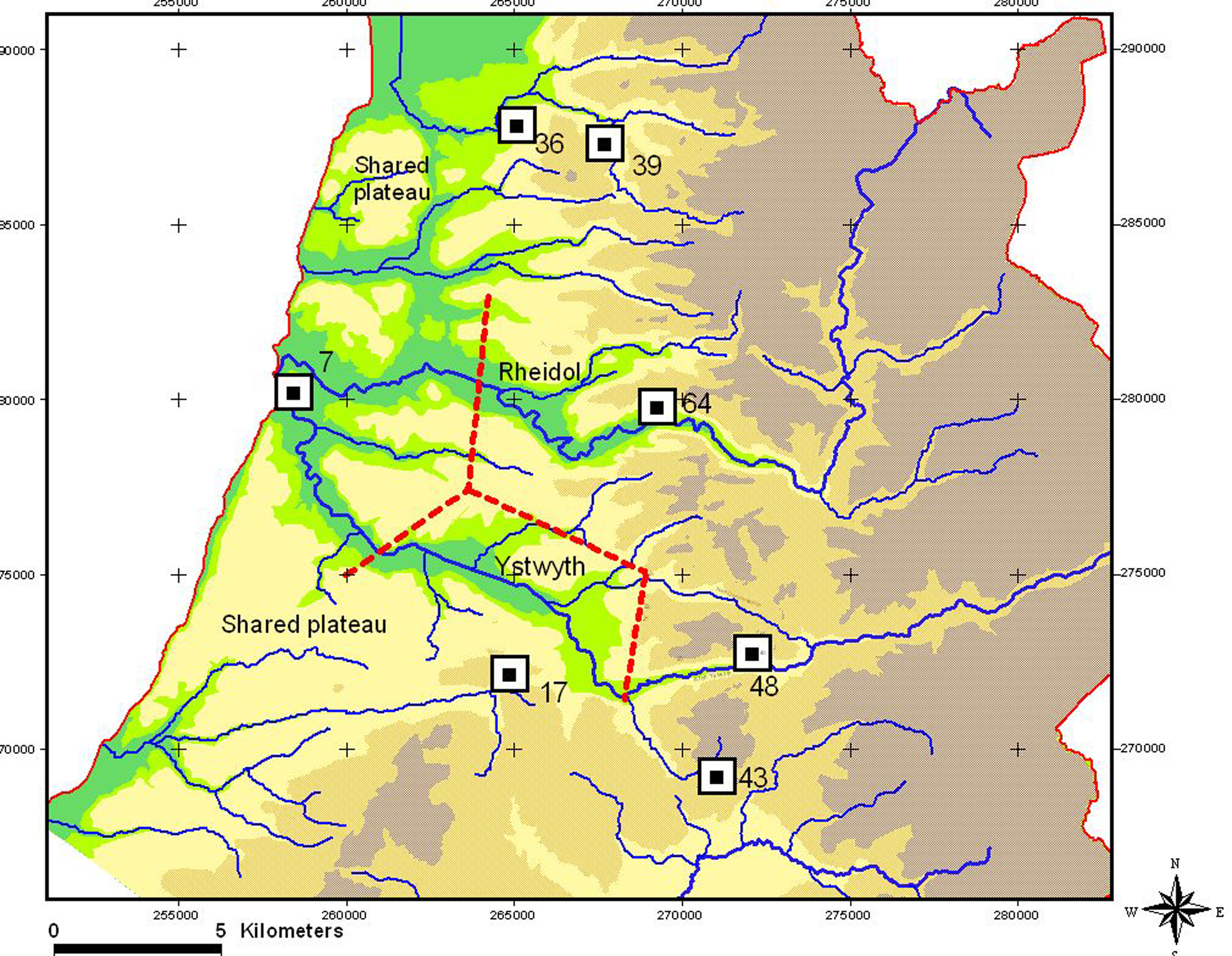
One can now also suggest parts of the landscape that may have been shared between the communities of key forts. To the south and north of Pen Dinas, Aberystwyth, the fertile coastal pastures are devoid of later prehistoric settlement. It is possible that the coastal pastures were set aside for specialist agricultural or pastoral use, much in the same way as the Severn Levels in Gwent, south Wales, were utilised as special seasonal wetland grazing areas during the Iron Age and Roman period (Gwilt 2007). This is supported by historical evidence of regional pastoral practices. In Jones' (1960) sociological study of Tregaron and area ('ardal'), to the south-east of Aberystwyth, the cattle-rearing potential of the west coast plateau was described; 'Cattle-rearing is the basis of farming on the coastal plateau to the west. The land is hilly, rounded, and almost bare of trees …' (Jones 1960, 84-5). In this respect we may be able to postulate that access to the productive coastal grasslands was controlled by the regional presence of Pen Dinas at its heart.
The regional map of similarly built Iron Age hillforts in north Ceredigion is the first step towards a deeper understanding of the landscape, and further research and investigation. A number of hillforts show evidence for occupation and development through more than one phase and so the final picture of how these groups emerged in the landscape may be complex, spanning one or more generations of activity. There was clearly a degree of social cohesion prevailing during the period that the hillforts were conceived, built or elaborated on earlier foundations. In their most impressive manifestations, the hillforts that shared the same designs stood as monumental symbols commanding particular vistas. Prime landscape positions such as outcrops and high hills were harnessed to enhance the appearance of the forts. The development of these different architectural traditions no doubt emerged from a clear desire to make a radical departure from other existing cultural traditions. They came to dominate the landscape, emulating the physical appearance of distant, 'exotic' hillforts found in wealthier, more cosmopolitan or technologically advanced parts of the Iron Age world, like the Welsh Borderlands. Referencing these distant, powerful communities would in turn have reinforced and legitimised the chiefly power of the elite in North Ceredigion. Thus architectural symbolism had become a powerful component in social control.
To what extent can we think in terms of a hillfort controlling and owning a surrounding territory? The nature of the society that existed at the time of the Welsh hillforts has been long debated, but whether we think of a chieftain controlling a tribe of people, elders overseeing extended families or wealthy farmers existing in much the same way as the Norman lords of medieval Wales, we have to assume somebody powerful and charismatic was in charge. The very existence of complex, monumental architecture suggests a hierarchy. Crucial to the concept of a new hillfort would have been the initial design idea, a strategy or impetus, from the person/s in control (Figure 10). In 1975 Hogg wrote that the decision to build a rampart implied a 'controlling authority', even if an ad hoc 'council of elders' (Hogg 1975, 69).
One of the longest-lived models devised to explain the role of large hillforts sees them as centres for storage and redistribution of the agricultural surplus drawn from the surrounding landscape, under the control of a powerful chieftain or leader. This social model of Celtic clientship was developed to interpret the great hillforts and later Iron Age landscapes of southern England, regarding the larger hillforts as 'central places', homes to wealthy elites who sat at the head of a strictly hierarchical society of noblemen, retainers and workers in the immediate fort, and occupying smaller forts and farms in the surrounding landscape (Cunliffe 1971; 1984; Hogg 1971). In recent years this straightforward view of the Iron Age based on historical sources has been challenged by a number of authors, some putting forward alternative views of hillfort function (e.g. Guilbert 1981; Hill 1995).
Hillforts undoubtedly exerted enormous influence over the landscapes around them, and some would certainly have owned or governed territory. Surviving boundary dykes and complex enclosed landscapes in parts of Britain away from Wales, notably Yorkshire, Wessex and the Cambridgeshire Fens, indicate that Iron Age communities could subdivide great areas, demarcating territory and clarifying ownership and control. For Fowler (1983, 188-96) at least some of these major land divisions were related to pastoralism and the management of herds. In the highly demarcated terrain of Wales, rivers probably acted as significant through-routes in the landscape, and potentially also as territorial boundaries. In one of Stanford's main studies of the hillforts of the Central Marches (1972, 313), he noted that streams and rivers provided ready-made boundaries, were valuable as watering places and for riverside materials and were thus probably 'desirable possessions' within society. A certain relationship between clusters of hillforts and 'valley junctions' was noted in Collens' (1988) study of Iron Age settlement in the Upper Severn Valley, Montgomeryshire. The large and complex Cefncarnedd hillfort at Caersws, Montgomeryshire, occupies the prominent ridge of a great spur of land that juts out into the lowlands of a significant valley junction, where the rivers of the Trannon and Carno join with the Severn; the valley bottom was later fortified by the Romans in recognition of its strategic strength. We have seen how Caer Drewyn, Corwen, exploited its 'tilting' location to overlook and command a key valley junction. The author's study of north Ceredigion hillforts (Driver 2013) also found that some were erected close to junction points on valleys that may have been significant places for trading, communication, and even for the division of territory. In a recent study of the coastal promontory forts of south Pembrokeshire (Barker and Driver 2011, 79-80) it was found that disparities and patterns in built settlements and 'empty' promontories could have reflected differential patterns of ownership or territory. In particular the marked isolation of Greenala Point promontory fort was interpreted as a potential 'exclusion zone' of owned or controlled territory around it, consistent perhaps with indications of high status inherent in its architecture. Here, then, we have Iron Age communities engineering their forts to play a strong role in trade, communication and the command of key lowlands where disparate communities may meet among the Welsh heartlands; it is no coincidence that marching camps and forts of the Roman legions frequently exploited the strategic potential of the same lowland valley junctions.
The variable positioning of hillforts in Wales suggests that a variety of considerations may have governed their eventual siting (Figure 11). In the study of the hillforts of Brecknock , the Royal Commission (1986, 9) noted that hillforts were sited '… on hilltops … all within easy reach of good or medium-quality land and adequate water' while 'Enclosures … on hill-slopes, appear to be sited at the transition between the open uplands and the more wooded valley slopes, indicating a mixed economic strategy' (RCAHMW 1986, 9). Bevan (1997, 185) observed similar factors in his discussion of Iron Age settlement in the Yorkshire Wolds, where 'Each settlement is situated within a very specific topographic zone, at the junction between upland and lowland. Both Staple Howe and Devil's Hill occupy spurs of the chalk outcrop that form promontories into the Vale of Pickering'. Access to these mixed upland and lowland resources would not just have been of economic importance in providing daily food, but also for their value in allowing the ownership and regulation of varied lands for the supply of a range of lavish foodstuffs, including game and conceivably seafood. This would have been essential fare to supply chiefly feasts and thus reinforce the position of a local leader (see Dodgshon 1998, 85-6). The results of the north Ceredigion study (Driver 2013) suggest that if the principal Pen Dinas-style hillforts were broadly contemporary then the regional landscape and its two major rivers may have been very closely controlled, all the way to the west coast.
Some authors (e.g. Woolf 1993, 213) have questioned whether the control of territory, as opposed to the control of people, characterised Iron Age society. In practice, patterns of land ownership and the control both of resources and people were no doubt complex, and subject to continual change. Dodgshon (1996, 101) discussed the two ways that historic Highland chiefdoms 'secured themselves', both as controllers of '… social networks of kinship and alliance and … as controllers of land and its resources'. Highland chiefdoms were '… cultivating men as well as land …'. In addition, clans drew meaning and relevance from being rooted in particular areas, and became 'broken clans' without land (Dodgshon 1998, 8, 13; and see Earle 1991). Natural, cultivated and human resources may to some extent be regarded as indivisible within a given territory, yet clearly each possessed quite different relative values for those in charge.
In summary, hillforts and defended enclosures are among the most visible settlements in the later prehistoric, pre-Roman, landscape but do not represent the only places people lived. Great swathes of Wales, particularly the uplands of Glamorgan and Gwent, are lacking in hillforts and defended settlements; those that do exist such as Maendy Camp above Ton Pentre, Rhondda, are isolated and devoid of close neighbours. It is thought that the many groups of stone roundhouses and associated field systems that co-exist in such areas, particularly at the head of the Rhondda Valley, on Hirwaun Common, and on the southern mountain slopes of the Brecon Beacons, may represent alternatives to hillfort settlement, and evidence for a very different rural economy (RCAHMW 1976, 72-9; Gwilt 2007, 301). Indeed, stone-built field systems incorporating roundhouses, yards and in-fields predominate on the west-facing coastal hills and islands of Wales, from Pembrokeshire in the south to the coastal and semi-upland slopes of Gwynedd (Driver and Browne 2008, 80-83). This great variety, complexity, and radical regional variation in the later prehistoric ways of life as seen in Wales only demonstrate that theories, models and ideas developed to explain the Iron Age in one part of the Principality may have little relevance in other parts, where the way of life may have been so different.
This article has introduced only some of the many complex issues that are brought into play when discussing hillfort architecture and function. It is has tried to reflect on past studies while advancing the debate a little, touching briefly on changing rampart and gateway technology (already comprehensively discussed in texts by Savory (1976) and Davies and Lynch (2000)) but focusing more on the ways we could be approaching, and thinking about, hillforts and their landscapes in the future.
Generalised, standardised approaches to hillforts as a 'monument resource' are all very well, but we need to develop an understanding of our Iron Age past. One way to kick-start our thinking about these sites is to re-engage with the monuments on the ground and to dwell upon the original aspirations, the engineering effort, the crucial decisions and the daily lives of its builders and inhabitants. This must be combined with modern, detailed re-surveys that seek to map the complex field archaeology of the hillfort in some detail, incorporating the natural terrain of the hilltop and any subtle, near-vanished earthworks. Ground-based remote sensing, as used on many plough-levelled lowland sites, can also enhance our understanding of hillfort interiors, particularly drawing out evidence of hearths and metal-working sites otherwise invisible without excavation.
As one of the greatest examples of mass engineering effort and communal achievement that Wales has ever seen, made all the more incredible by their inception in prehistory, hillforts and Iron Age settlements cry out for a deeper appreciation and understanding among the present population of Wales. Beneath these tumbled ramparts and tree-grown gateways survive the built aspirations and exceptional vision of Wales' early architects.
Internet Archaeology is an open access journal based in the Department of Archaeology, University of York. Except where otherwise noted, content from this work may be used under the terms of the Creative Commons Attribution 3.0 (CC BY) Unported licence, which permits unrestricted use, distribution, and reproduction in any medium, provided that attribution to the author(s), the title of the work, the Internet Archaeology journal and the relevant URL/DOI are given.
Terms and Conditions | Legal Statements | Privacy Policy | Cookies Policy | Citing Internet Archaeology
Internet Archaeology content is preserved for the long term with the Archaeology Data Service. Help sustain and support open access publication by donating to our Open Access Archaeology Fund.