
Department of Archaeology University of Southampton Southampton SO17 1BJ. Email: [email protected]
Cite this as: Wheatley, D. 1998 Review of Johnson, I. and North, M. (eds) 1997 Archaeological Applications of GIS: Proceedings of Colloquium II, UISPP XIIIth Congress, Forli, Italy, September 1996 Sydney University Archaeological Methods Series 5[CD-ROM], Internet Archaeology 5. https://doi.org/10.11141/ia.5.6
Price details and ordering information about this CD-ROM can be found via the University of Sydney web pages.
Unusually in a review, the first comments need to be directed to the medium of publication itself. This is inevitable, given the decision to produce the Proceedings of the Forli Colloquium on CD-ROM, rather than as a conventional volume. The main advantages of this ought to be the ability to use media other than monochrome graphics (such as colour, video and sound) and the availability of hyperlinks, which provide freedom from the serial structure of text. The disadvantages are that reading from a screen can be very tiresome and referencing, in a formal way, is made more difficult by the lack of page numbers etc.
The discomfort of reading from a screen is a problem that is in part a function of the particular screen and the particular reader. The structuring of the papers, with small sections in separate files, makes for easier reading on screen because the amount of scrolling is minimised, although the orange background for the text is extremely tiresome after a while. Navigation controls are basic, with a menu at the top of the each section but each paper's table of contents plus the ubiquitous 'Next', 'Previous' and 'Top' are annoyingly only available at the bottom of each page. The format makes it difficult to print the papers and, given that many readers are likely to have poor screens or poor eyesight (or both), a good solution would have been to provide printable versions of the papers on the disk, perhaps in postscript or Adobe Acrobat (PDF) format. Certainly there would have been space on the disk, which is less than half full.
The use of hypertext is limited to a few pointers to WWW resources, although the references within papers are conveniently linked to the bibliography for that paper so that the highlighted citation takes the reader immediately to the reference. The papers include colour images, restricted to maximum 800x600 pixels - again it should have been straightforward to provide alternatives for those with larger or smaller screens.
The format chosen for publication, HyperText Markup Language (HTML3), quickly reveals itself to have both strengths and weaknesses. The main strength is that any WWW-browser can be used to view the papers and their associated graphics. I used both Netscape 4 and Internet Explorer 3, without any problems. This means that the volume is (in theory) platform-independent, although a few of the resources included - notably PowerPoint slides and animations - require the user to have additional software. Obviously, those who do not have a WWW-enabled computer are entirely excluded, although it might be argued that a volume on GIS applications is unlikely to be of interest to those without access to those facilities.
The volume contains thirty-seven 'papers' plus some teaching resources and an annotated bibliography. Contributions are arranged into six topics: Landscape, Environment and Simulation, Wide Area Studies, Theory and Method, Site-based Studies, Surveys and Site Patterning, and Cultural Resource Management and, although the grouping of papers is never easy because they inevitably overlap whichever themes are chosen, this arrangement seems particularly arbitrary. Why 'landscape' 'environment' and 'simulation', for example, should be grouped together is hard to fathom, as they each seem to have less in common than, say, 'landscape' and 'site patterning'.
Things are not helped by the discussion of the themes (there are none) or an indication of what the topics are intended to mean (also not provided). It would have been a trivial exercise to provide several alternative arrangements of papers but, apart from listing by author's name, this merely reproduces the linearity of a traditional text and leads to some odd groups of papers.
Figure 1: The orange background becomes tiresome after a
while, and the only two choices of entry to the papers are by topic
and by author's name
It seems that the editors have missed an opportunity afforded by the publication medium. Just to be contrary, therefore, the rest of this review arranges the contributions into another (probably equally arbitrary) set of themes.
It is surprising that, since Castleford (1992), archaeological applications of GIS have shown little inclination to address time-depth and historical factors. It is encouraging, therefore, that this volume begins to show some evidence that this is beginning to be put right, and three approaches to time are evident in this volume. The first is simply to make 'time slice' distribution maps that can be viewed sequentially or animated, the second combines simulation studies with GIS while a third approach uses the z-dimension, or attribute data, to represent time.
The first, and least analytical of these approaches is characterised by Dean Snow's contribution to the Wide Area Studies section. He presents distribution maps of 847 dated Iroquois village sites, and gives an historical account of the demographic changes revealed. While the paper only makes use of the display capabilities of GIS, it does use animation to present time-slices in ten-year intervals and the technology is appropriately used to link data and interpretation. The study reveals 'long-term trends that are inexplicable, and probably undetectable, at a local spatial scale or over the short term'. The mapping abilities of GIS are also used by Levy to plot the distribution of Bronze and Iron Age survey data in the Canaan Highlands. Although this is also not analytically complex, the results are a useful visualisation of the data, allowing the author to make some pertinent observations about the sequence.
The second approach to time is exemplified by Hansell and Ranere's attempt to simulate the deforestation of Central Panama, producing results that compare favourably to known site distributions and sizes. Kohler and Carr use a more sophisticated multi-agent simulation to generate simulated household densities. They are surprisingly undeterred to find 'little agreement between these simulated results and the settlement distributions known from the archaeological record' and propose to 'add incremental complication to agent behaviour' to counter this. The strength of both of these papers lies in their focus on the substantive analysis of time achieved by the simulation of changing spatial patterns. Both also refer these results back to the material record, retaining a firm connection to archaeological observations. Verhagen and McGlade also advocate dynamic modelling as a method for analysis of temporal and spatial elements together. This goal is carried out through the construction of an ecological model of a region of the Vera basin in south-eastern Spain. The model is mathematically sophisticated (or at least complex), incorporating components for the Soil System (litter, organic matter, mineral soil and soil-water) and Mattoral vegetation with grazing although, unfortunately, no results are published. Given McGlade's acceptance (see below) that cultural perception is a component of landscape, there is a marked absence of any discussion of social aspects of landscape formation.
The third approach is apparently adopted by Nuñez et al., who discuss 'timescapes' in a non-static geomorphic region, although it is not entirely clear what their 'timescapes' actually are. They say that "the method initially used in creating the geo-landscapes was also applied to the creation of time landscapes (timescapes)", from which we might deduce that the 'timescape' is an interpolation from the dates of the sites. If so, there is no explanation of which interpolator was used or of how sites with date ranges were treated. Typical of the virtually incomprehensible method section is the following paragraph, whose meaning still seems as obscure and ambiguous as the first time I read it:
"The final test was correlating the timescapes with the positional aspects and geography of Åland and its sites. By using a multiple surface approach and maintaining constant surface-view criteria, we created comprehensive images containing the geodatasets and points and their attribute data combined with the drape of a temporal landscape."
Trella and Zubrow's paper also generates contoured surfaces from time data although, like several others, it is more of a note than a paper. It briefly recounts a study which re-applies the Ammerman and Cavalli-Sforza (1984) 'wave of advance' model for the spread of agriculture through Europe to North America.
Two papers use GIS in the analysis of environmental data, and these too exhibit a growing desire to develop diachronic forms of analysis. Spikins uses environmental preferences, climate change and pollen data to model the large-scale changes in vegetation through the Mesolithic. The result gives snapshots of the changing patterns of vegetation between 10,000BP and 5,000BP. The model is then used to argue for a "a shift in the spatial location of the most productive terrestrial resource zones in the Mesolithic and a fragmentation of these zones through time", which is supported by reference to the Mesolithic archaeological record.
Martlew's paper uses GIS to plot the distribution of plant communities obtained from Principal Components Analysis of pollen data. Unfortunately, no details of the PCA are given, and the reader is left to guess, for example, how many input variables were used, and whether they were percentages, relative percentages or absolute numbers of pollen grains. There seem to be only five cases involved in the analysis, and no explanation is provided of the method used to interpolate from the rather meagre five sample locations to the rest of the landscape or, indeed, why interpolation was valid with so few points.
Uncomfortably classified into the Landscape Environment and Simulation section, is Mark Gillings' attempt to put a new twist on his work on the flood characteristics of the Tizsa plain (Gillings 1995). This is re-worked to build a critique of the use of visibility analysis within archaeology that makes some good points, although the only tangible outcome is an animation that descends from above the floodplain to eye level. Certainly, it is possible to see more water from this position, but beyond this the meaning is somewhat obscure. The claim that this approach will show that GIS "can be used to articulate and explore the complex and highly intertwined relations between people and place that characterise past human-landscape interactions" (gillings/gillings_1.html) is welcome, but not demonstrated. Most of the papers that find their way to the Theory and Method section are concerned only with method (see below) but one exception is McGlade who, like Gillings, accepts the critique of 'atheoretical' studies. However, McGlade argues that "it is not a 'post-processual' GIS that is required, but rather a resituating of the role of GIS technology within a more pluralistic approach to the production of archaeological knowledge." There is much to recommend McGlade's position: while accepting much of the post-modern critique of positivist science, he regrets that formal methods have been undervalued, and advocates a more pluralistic approach to interpretation using the tools of GIS.
There is no ambiguity to the theoretical position of Voorips, who concludes the Theory and Method section with a debating piece that rejoices in the title 'Archaeological theory and GIS: any relationship'. After a short (if somewhat north American) overview of the development of GIS, he nails his colours firmly to the positivist/empiricist mast. "It may be old-fashioned, but I still believe that archaeological theories should be scientific theories". The paper then explains how GIS fits into processual archaeology. Readers will not need to agree with Voorips' position to find the paper a clear and useful statement of a viewpoint that is widely held but rarely so clearly expressed.
One criticism that could be raised of Spikins' interpretation is that of 'environmental determinism'. Although the use of that label has recently been decried by Kvamme (1997, see Wheatley 1998 for a response), it is difficult to avoid when there is such a wide selection of papers whose claims to explanation derive solely from the quantification of associations between archaeological and environmental variables.
The Surveys and Site Patterning section begins with Kirkinen, who compares later Iron Age settlement patterns in eastern Finland against the usual range of environmental variables. The paper concludes that "the settlement process favoured fine-grained soils, soil fertility and water bodies" and "settlement seems to have generally favoured similar environmental resources in both the center and the peripheral research areas". Encouragingly, he finds that "it is not possible to point to a single environmental factor that has drawn settlement to Mikkeli". McClung de Tapia and Tapia-Recillas perform a similar analysis for the Prehispanic settlement in the Teotihuacan region of Mexico. In this case the patterning is evaluated using traditional significance tests, which also indicate little association between the selected landscape metrics and site location.
Vullo and Barker report on the use of GIS in the analysis of survey data. They identify problems of data collection, sampling and recovery bias but still conclude that "the results ... do not seem to indicate any locational preferences during any of the periods considered, apart from a positive association, in all three periods, between sites, Marine/Tertiary formations along watercourses and calcareous mediterranean brown-earth soils". This is interpreted as evidence of preference for the best soils for cultivation, while the absence of sites on other highly fertile alluvial soils is explained as recovery bias. The paper also discusses clustering of sites and the distribution of off-site pottery clusters.
These are all thorough and rigorous studies, although they might show more awareness of the numerous other published examples of their chosen methodology. However, it is depressing that, despite five years of discussion in the GIS literature, none address the possibility that the choice of site location might be a product of historical sequence or social factors rather than environment. This gives an impression that the theoretical sophistication of much GIS work has not progressed since Kvamme and Jochim's (1989) paper on the environmental basis of Mesolithic settlement.
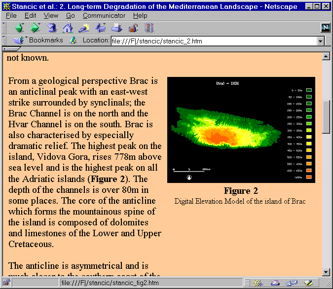
Thomas Saile covers the well-trodden ground of using GIS to apply site catchment analysis, this time with the justification that: "In determining the location of a rural settlement, the nature of the soil in the surrounding area was one of the main factors". Like Hunt (1992), Saile uses circles to estimate site territories rather than take account of natural barriers or terrain. The results are then analysed with Principal Components Analysis to suggest three different types of landuse in different periods. By contrast, Stancic et al. also use site catchments to explore the results of a field survey project on the island of Brac, Slovenia.
Figure 2: Not Hvar, but the nearby island of Brac is the subject
of Stancic et al.'s contribution. The graphic with the text is too small to
convey much information so it is linked to a larger version.

In this case, however, Thiessen polygons, circular catchments and cost-surface catchments are all used and the authors also explore the use of viewshed analysis, arguing that this constitutes a "shedding of the shackles of functional and economic determinism". Although the paper does pay lip service to 'large scale cognitive phenomena' it fails to address issues of historical sequence, cosmology or ideology which ought to be central to the interpretation of spatial patterns in prehistoric material.
Robert Theunissen uses site location modelling at an intra-site scale, in this case rock-shelters. Like Gisiger (see later), Theunissen's paper derives from work undertaken as a student but Theunissen has chosen to write a new paper rather than take the opportunity to reproduce his thesis. The result is original in that it applies an approach more typical of regional analysis than individual sites. Following a discussion of the taphonomy of rock shelters (particularly the effects of trampling and water), the author uses GIS to map these factors and then create a predictive model of artefact frequency that confirms that shelter topography is a significant influence on the artefact distribution.
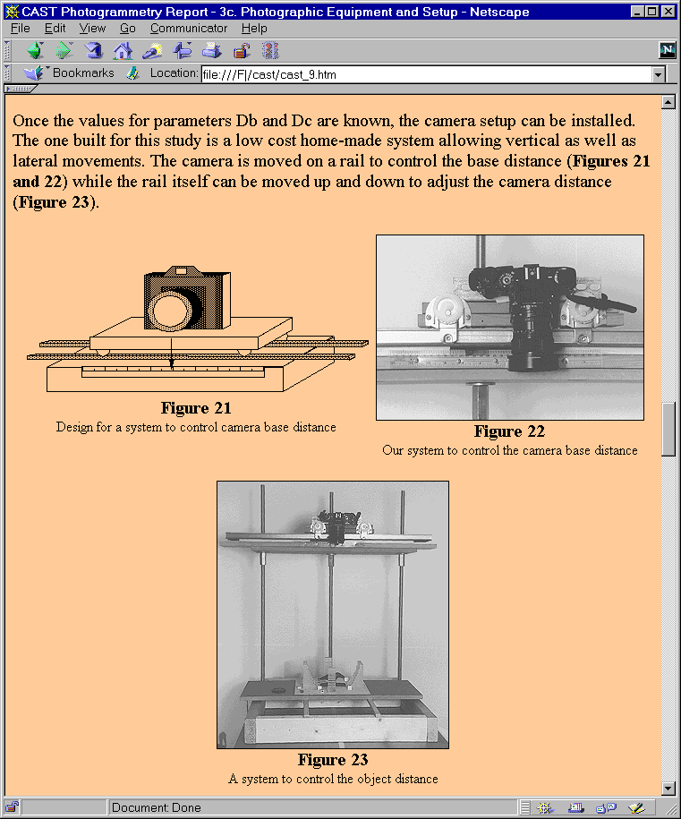
The section, on Theory and Method, begins with a reprinted final report (Gisiger et al.) of the Center for Advanced Spatial Technologies (CAST) project to develop "a rapid, low cost method of recording archaeological artifacts and osteological materials in a manner that will allow retrieval of metric information at a later time". This is a long report, which reviews the use of photogrammetric methods in general before describing their method in some detail.
Figure 3: From Gisiger et al.'s paper on
photogrammetric methods. The graphics are informative enough, but why are
they in monochrome? Possibly because this is simply reproduced from a
paper source without seeing the need for re-writing or re-formatting.
Rhode and Rager use GIS to control for microclimatic variations that affect the hydration rate of obsidian, and hence estimated dates. They model the effective hydration rate, and apply this to the sample of measurements, concluding with a discussion of the settlement patterns using distribution maps corrected for hydration variation. The contribution by Holdaway et al. might have been better suited to the section on survey than the Site Based Studies section. Like others, it is not really a full paper but more an electronic poster in which the authors investigate the distributions of Aboriginal stone artefacts whose vertical integrity is compressed, while the horizontal patterning is apparently intact. Interesting though it sounds, there is not sufficient detail to make any informed judgements.
A discussion of existing methods is provided by Limp (a reproduction of the pre-congress publication for Colloquia I and II) in a comprehensive and well-written overview of the use of GIS and spatial methods within archaeology. It includes sections on Exploratory Data Analysis, Landscape Visualisation, Global Positioning Systems, Multispectral image analysis, Digital Photogrammetry, Synthesis and Sample Design. Personally, I would have paid the asking price for this alone, and will ensure that it is among the first things that my GIS students read next year.
Genuinely new quantitative approaches are offered by Kvamme and Reeler. Reeler's contributions seem to be one paper masquerading as two - the first advocates and explains artificial neural networks and fuzzy logic, while the second details an application of these in the classification and interpretation of Maori Pa sites in New Zealand. Kvamme offers a short but typically thorough discussion of the methodological benefits of Monte-Carlo significance tests within spatial analysis.
Several of the contributions are concerned with the use of GIS to manage, and then analyse archaeological data that are not collected explicitly for GIS. Stoddart, Belcher and Harrison address the important question of whether data acquired during a long survey project (in this case the South Etruria survey) are adequate for GIS analysis. Their conclusion that "sophisticated technology can give a false impression of veracity and operate along lines of positivist certainty that are no longer held by the majority of the academic community" will ring true with many who have worked with field survey data. Nǿrbach's short discussion of the site of Drengsted discusses the scanning and vectorising of site plans (which are included on the disk in MapInfo format) and Johnson's paper on the handling of raster data within MapInfo is interesting and potentially useful, but the author himself reports that the paper was written in 1995 and that, by the time it was published, there were software products available which supersede those described.
The final Cultural Resource Management section includes several examples of GIS adoption into archaeological management. Bampton and Hamilton, discuss the creation of and Arc/Info database for Casco Bay, Maine, USA, while Flyg reports on a pilot study relating to the adoption of GIS by the Swedish Board of National Antiquities and Göldner provides an account of the Department of National Heritage, Dresden's creation of a 10,000 site database. Richard MacNeill's contribution is more analytical, and reports an attempt to define and map archaeological 'sensitivity', first with predictive modelling and latterly with controlled area summaries. The CRM section is completed by Torsten Madsen's account (subtitled 'A Tale from the Real World') of why GIS had been slow to be adopted in Scandinavian Archaeology. Ironically, he concludes that the dichotomy between research and administrative archaeology is, at least in part, to blame, which neatly undermines the volume's decision to lump together the four papers into a kind of 'management ghetto' at the end of the volume.
There are a few minor criticisms that could be raised against this volume. Firstly, the themes selected to group the papers seem awkward: if the authors wanted to make some kind of statement by organising the contributions in this way, then the meaning is unclear. If not, then the electronic format could have provided the ideal vehicle for offering a variety of different themes or access methods. Even within the restrictions of HTML3, the format could be better: the controls are limited and the orange background is not comfortable. These, however, are not the publication's real problem which lies in the fact that the editors do not seem to have decided what this publication is. If it is intended as the successor to Allen et al. (1990) and Lock and Stancic (1995) then printable copies of the papers and guidance on referencing should have been provided. The volume fails in this light mainly on academic grounds, however, because some papers (e.g. Nuñez et al., Martlew) lack crucial detail that should have been picked up in the peer-review process, while others, which are little more than posters (Holdaway et al., Spikins, Nørbach) are not distinguished in any way from fuller contributions. Several, such as Anne Gisiger's MA thesis, and the CAST report (Gisiger et al.), are simply reproduced from elsewhere and while their quality is not in doubt, the appropriateness of their inclusion without clearly distinguishing them from the original material is doubtful.
Given the quality of many of the papers, which would warrant inclusion in a serious academic publication, it is an unfortunate conclusion that this cannot be taken seriously as a refereed edited volume. As a teaching resource - which it clearly represents in respect of the extra materials provided - it has many strengths. However, it would have been a simple matter to make a statement about the refereeing policy and then to make a clear distinction between the 'papers' and other materials, much as many journals distinguish between full papers and notes. This would have enabled the CD to fulfil both roles and, as in so many other ways, this is a missed opportunity.
The publication is important simply because it is the most recent publication on the archaeological application of GIS, providing an insight into the development (or not) of the application of GIS to archaeology. Much of the content is of very high standard, and some of the rest makes interesting reading. However, there remain serious question marks about the editors' unwillingness or inability to request obvious changes to some papers, and the lack of a clear distinction between reviewed academic material and the other types of contribution.
Allen, K.M.S., Green S. and Zubrow E.B.W. (eds) 1990 Interpreting Space: GIS and Archaeology. Taylor and Francis. London.
Ammerman, A.J. and Cavalli-Sforza, L.L. 1984 The Neolithic Transition and the Genetics of Populations in Europe. Princeton University Press. Princeton.
Castleford, J. 1992 Archaeology, GIS and the time dimension: an overview. In Lock, G. and Moffet, J. (eds) Computer Applications and Quantitative Methods in Archaeology 1991. British Archaeological Reports, International Series S577. 95-106.
Gillings, M. 1995 GIS and the Tisza Flood-Plain: Landscape and settlement evolution in North Eastern Hungary. In Lock, G. and Stancic, Z. (eds) The Impact of Geographic Information Systems on Archaeology: a European Perspective. Taylor and Francis. New York.
Hunt, E.D. 1992 Upgrading Site-catchment Analyses with the Use of GIS: Investigating the Settlement Patterns of Horticulturists. World Archaeology 24. 283-309.
Kvamme, K.L. 1997 Ranters corner: Bringing the camps together: GIS and ED. Archaeological Computing Newsletter 47. 1-4.
Kvamme, K.L. and Jochim, M.A. 1989, The Environmental Basis of Mesolithic Settlement. In Bonsall, C. (ed) The Mesolithic in Europe Papers Presented at the Third International Symposium, Edinburgh 1985. 1-12. John Donald. Edinburgh.
Lock, G. and Stancic, Z. 1995 (eds) The Impact of Geographic Information Systems on Archaeology: a European Perspective. Taylor and Francis. New York.
Wheatley, D.W. 1998 Ranters corner: Keeping the campfires burning: the case for pluralism. Archaeological Computing Newsletter 50. 2-7.
Internet Archaeology is an open access journal based in the Department of Archaeology, University of York. Except where otherwise noted, content from this work may be used under the terms of the Creative Commons Attribution 3.0 (CC BY) Unported licence, which permits unrestricted use, distribution, and reproduction in any medium, provided that attribution to the author(s), the title of the work, the Internet Archaeology journal and the relevant URL/DOI are given.
Terms and Conditions | Legal Statements | Privacy Policy | Cookies Policy | Citing Internet Archaeology
Internet Archaeology content is preserved for the long term with the Archaeology Data Service (ROR). Help sustain and support open access publication by donating to our Open Access Archaeology Fund.