Fig. 1.1 West Heslerton Anglian settlement
The excavation of the Early Anglo-Saxon settlement at West Heslerton, North Yorkshire, undertaken on a seasonal basis between 1986 and 1995, has produced evidence that indicates we have under-rated the complexity and sophistication of settlement development in the Early Anglo-Saxon period. Prior to the completion of work on the site during 1995, it appeared that there was little that was exceptional about the nature of the settlement at West Heslerton and that the site may have followed what might be proposed as a standard sequence of development from a Late Roman farmstead to a Late Saxon settlement. The new evidence has cast some doubt on this view, with the Late Roman activity at the site relating to a ?shrine and ?temple complex rather than to domestic settlement. There is good reason to see this ritual component at the site continuing as an element of the Early Anglo-Saxon landscape and it appears that this aspect provided the impetus for settlement at this location during the Early Anglo-Saxon period. It is perhaps most remarkable that there was no indication of the ritual nature of the settlement core in areas examined prior to the final season. The new evidence offers the possibility of a somewhat unique context for the Early and Middle Saxon settlement and makes it even more important to establish to what degree, this, the most extensively excavated site of its kind in England, can provide a testable model of settlement morphology and evolution during the formative years of the English nation.
Excavation of the Anglo-Saxon domestic deposits is now complete and although many questions relating to the Roman to Saxon transition remain unanswered, the comprehensive excavation of the Anglo-Saxon features reveals a remarkable settlement of unparalleled size and complexity.
The theory put forward prior to the last season's work, that the settlement relocation, which is a feature of the Early Anglo-Saxon period, may have had its roots in a major re-organisation of land-holding structure in the closing decades of the Roman period gains less weight from the new evidence. The excavation, one of the largest ever undertaken in Britain, has produced a wealth of new and important evidence, the importance of which is both intrinsic to the material itself and also a consequence of the uniform and detailed record generated in the field. The excavation has been the setting for one of the most extensive applications of computers in the field and has produced perhaps the most significant spatially referenced data-set for any site of this period. The excavation has formed the proving ground for a number of innovative approaches to data collection, recording and management which have an importance extending beyond the regional or temporal boundaries of the site in its local setting.
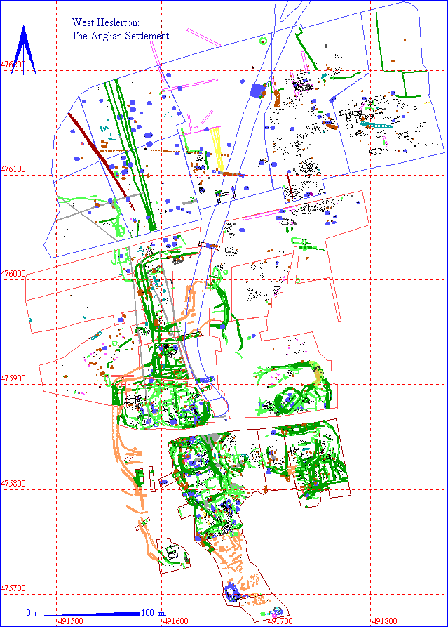
The settlement covered a far larger area than was originally anticipated, Early Anglo-Saxon features being widely distributed over an area of more than 13ha (32 acres). The layout of the settlement includes a remarkable degree of spatial variation with distinctive areas for housing, craft/industry and agricultural processing and indications of a deliberate separation between secular and ritual space. Much of the northern half of the settlement was without any internal divisions or property boundaries, although there is good evidence which shows a high degree of organisation or planning. The occupation and associated activity in the southern half of the settlement contrasts with that to the north in that an extensive network of ditched and fenced enclosures span the complete period of occupation at the site. At the southern limit of the domestic occupation a series of large post-hole structures and substantial fence slots define the boundary between the secular space and the ritual space which dominated the Late Roman landscape and were contained within a dry valley running due south to the foot of the north-facing scarp of the Yorkshire Wolds.
Excavation has included the examination of over 220 structures including 130 Grubenhäuser and at least 90 post-hole structures; all are interpreted as having had raised floors, providing a dry air space beneath. The function of a number of the Grubenhäuser as grain storage buildings can now be demonstrated from the environmental evidence. In other cases they appear to have formed general purpose storage buildings associated with small-scale craft and industrial processes, and animal processing. There is no clear evidence that these structures served as housing or as weaving sheds as has been suggested in the past, although debris from weaving activity is plentiful in their fills. Ultimately, following the decay or removal of the structures themselves, the pit sealed by the floor boards was filled with rubbish. The data from these features offer immense research potential. The problems of dating and sequencing sites of this class will require extensive multivariate analysis of the Grubenhäuser fills which include material indicating the survival of this structural type until the desertion of the site in the 9th century AD. An analysis of the post-hole structures from this site and other published examples indicates that, in contrast to the view most recently expressed by Marshall and Marshall, these buildings utilised tie-beam construction and could in the larger cases have incorporated an upper storey (Marshall and Marshall 1994). The extensive complex of overlain enclosure ditches which dominated the southern part of the settlement provide a complete stratigraphic sequence covering the life of the site and make it possible to try and identify individual 'properties' whilst providing a complete contrast to the open-plan nature of most of the site to the north. Clearly, the initial layout of enclosures can be attributed to the Roman activity associated with the activities in the valley behind, but when the settlement was finally deserted many of the early enclosures were still in use although each had been redefined a multitude of times. An extensive programme of phosphate data collection and analysis undertaken during the 1995 excavation season coupled with soil-micromorphological analysis may assist us in determining the degree to which these enclosures served primarily as stock compounds.
The site has produced one of the largest and best documented environmental data-sets from a site of this period, with one of the largest and most complete faunal assemblages, the analysis of which will have considerable bearing upon the comparative analysis of the large Roman and medieval assemblages from urban centres. The initial examination of the plant macro-fossil evidence indicates that a wide range of species are present, including cereal crops as well as fruits and berries; the majority of the crops appear to have been grown on the broad flat margins of the Vale of Pickering to the north of the site. The examination of the charcoal has revealed a surprising variety of species. Although oak and hazel dominate the assemblage, there is extensive evidence of fruit woods, perhaps indicating the maintenance of orchards. Soil micromorphology has shown an increase in agricultural activity at the foot of the Wolds during the Roman period and demonstrated the use of some of the enclosures for stock, perhaps including wintering of animals within the immediate vicinity of the settlement core to the south. The presence of a possible mill in one area was indicated by clear signs of water-course management, the distribution of querns, and a series of features identified through geophysical survey; because of limited time and resources it was not possible to examine these features were not examined and a tree plantation now covers the site. The landowner has since offered to keep the area clear of further tree cover once the present crop of Christmas trees are removed.
The site has produced a large artefact assemblage of considerable significance. For example, long-distance high-volume trade is reflected in the significant quantities of Niedermendig lava quernstone fragments and hone stones. High status items such as glass vessels are not common in the assemblage; their distribution, however, increases towards the southern end of the site where there is a greater likelihood of Roman residual survival, and yet most fragments appear to be Saxon rather than of an earlier date. The wealth of artefacts and ecofacts and the high quality of the record provides an opportunity for the examination of disposal practices, fragmentation, preservation and site formation processes to a degree not possible from smaller scale excavations.
The integrated analysis of the evidence from this site will form the basis of Early Anglo-Saxon settlement studies for a considerable time into the future. The site has relevance far beyond its local setting and, given the combination of both excavated settlement and cemetery, offers a unique opportunity to test aspects of social structure and ethnicity identified in the interpretation of the cemetery within a settlement context.
The comparative analysis of the results from West Heslerton, combined with other settlements examined in the past, will allow testing of morphological models without extensive new excavation, and reveal to what degree the national uniformity reflected in the architectural styles is also present in the overall settlement organisation and layout.
The use of a variety of different techniques for sampling and recovery combined with the highly computerised nature of the record provide an opportunity to validate and compare field techniques in a way not possible from smaller or older data-sets. The site has generated a tremendous resource of well-recorded data, all of which should ultimately be available in digital form and as such provides a research platform for model formulation and testing that should go far beyond that which is possible in the analytical programme. The vast quantity of spatial data makes it possible for the first time at a large scale to evaluate sampling strategies against a known data-set. Residuality, variability of survival, disposal practices and site deformation processes contribute to the uniqueness of all 'sites'; however, rarely do we see sufficient data to be able to address these questions which underlie our ability to interpret what survives in the ground. Although the data collection regime applied on site drew heavily on the application of computers, this demanded a rigour that could be irritating to the point of boredom for those recording every day and relied more on attention to archaeological detail than any hi-tech wizardry.
In addition to the important data-sets from the Roman to Middle Saxon periods, the site has added significantly to the prehistoric data-set generated from the Cook's Quarry Site, with which it forms a valuable resource for understanding the development and use of the later prehistoric landscape (Powlesland et al. 1986). The soil history in particular provides a detailed picture of the transition from the Prehistoric to Roman periods.
The examination of the Early and Middle Saxon settlement deposits is now complete, and although there remain many questions, particularly relating to the Roman and possibly earlier religious complex, the excavation of these deposits was far beyond the scope of this project and the area has now been back-filled following the extraction of the Early and Middle Saxon settlement data. To have attempted to undertake more detailed examination of the late Roman structures and associated deposits in the valley above the site would have compromised our ability to complete the somewhat larger than anticipated body of work that presented itself in the last season and deprived us of valuable data which will make the analytical programme so much more rewarding.
Fig. 1.1 West Heslerton Anglian settlement
© Internet Archaeology
URL: http://intarch.ac.uk/journal/issue5/westhes/1.htm
Last updated: Tue Dec 15 1998