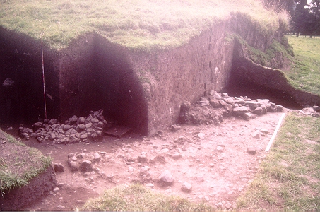
Figure 8. Excavation through mound and showing structure exposed beneath mound, 1997. View gallery image 27 for aerial view of mound
In 1997, the first programme of excavation was carried out, cutting a profile through one of the medium sized tolas at the north-western entrance to the Quebrada San Pedro. The mound tested measured approximately 35m in diameter and 6m in height overall. A trench was cut at the base of the mound on its eastern side exposing the original land surface beneath the mound with a line of dry stone walling constructed of large stones and cangagua blocks, forming part of a structure which pre-dated the mound (Figure 8).
Figure 8. Excavation through mound and showing structure exposed beneath mound,
1997. View gallery image 27 for aerial view of mound
Only a small section of the structure could be exposed, which appeared to be the walls possibly of two semi-circular buildings over which the mound had been raised. There have been reports of other mounds covering the remains of structures, both at Zuleta by those involved in occasional levelling of mounds here in the past, and in references to earlier work at other archaeological sites (Jijon y Caamaño 1952; Espinosa Soriano 1988). Pottery recovered was typical of the Late Period in the northern sierra, similar to that from other Late Period Cara sites such as Socapamba, including rim sherds of the diagnostic Socapamba 'amphora' with exterior vertical red line decoration (Athens 1980, 213-20) and Caranqui-style pottery recovered through other archaeological surveys in the region (e.g. Bray 1991; 1992; 1995a). Exotic elements are represented by the finding of a few sherds of Cosanga-Pillaro (Panzaleo) pottery, which is a not uncommon finding for these Late Period settlements and suggests contact either directly or indirectly with the eastern montaña (Bray 1995b, 144). A carbon sample for radiocarbon analysis was taken from charcoal close to the palaeosol exposed beneath the mound and produced a date of 883 ± 80 BP (UB-4319; wood charcoal; 13C = -26.245+0.200. Calibrated at 2 sigma with the University of Washington Radiocarbon Calibration Program 1987 Rev. 2.0 (Stuiver and Pearson 1986). The calibrated values at two sigma are 950-680 cal. BP (intercept at BP 785) or cal. AD 1000-1270 (intercept at AD 1165). The mound itself was found to have been constructed of irregular blocks of earth or turf, some clearly visible in the exposed section face (Figure 9), and some of these blocks included lenses of volcanic tephra identified as deriving from the eruption of Quilotoa volcano in c. 800 BP (Patricia Mothes, personal communication 1998) - For a detailed description of the petrography and geochemistry of Quilotoa eruptive products, see Mothes and Hall 1998b: 118-121. This fact clearly demonstrates that both this and other large mounds at the site, partially cut by modern agricultural activity to expose their compositional matrix, post-dated the Quilotoa eruptive episode.
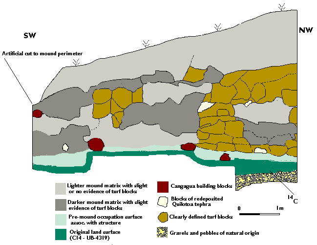
Figure 9. Hacienda Zuleta: profile drawing of mound excavated in 1997
© Internet Archaeology
URL: http://intarch.ac.uk/journal/issue10/currie/4sec2.html
Last updated: Thu Apr 5 2001