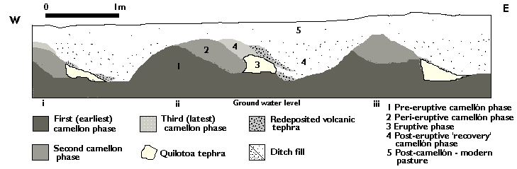
Figure 11. Profile drawing of sector 4 of the water pipeline trench cut
Figure 11. Profile drawing of sector 4 of the water pipeline trench cut
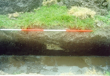
Figure 12. Camellón ditch infilled with Quilotoa tephra between two camellón
mounds in sector 4 of the water pipeline trenchcut, showing different phases of use
View other images from pipeline trench in the gallery (nos. 33, 34, 35)
Sector 4 (see Figure 2) was the first observed to have the distinctive greyish white ash drying on the top of the spoil from the pipeline cut. A cut 6m long by slightly over 1m deep was made, and the northern side cleaned back for photography, drawing and sample-taking. The exposed stratigraphy revealed a series of up to three distinguishable phases of three parallel camellones with their intervening ditches, oriented along a line approximately north-north-west by east-south-east, with a 'wave-length' (distance from the top of one camellón ridge to the next) of about 2.5m and an 'amplitude' (overall height from ditch bottom to camellón top) of around 0.55m. The top of the latest phase of camellones lay between 0.20 and 0.30m below the present day surface. The ditches of the second camellón phase had all been infilled with fine white volcanic ash, which had subsequently been re-cut in a clear attempt to recover the fields. The re-cutting operation had only been partially achieved, however, leaving a dense wedge-shaped plug of ash filling in the original ditch. Samples of the ash taken from this and the other sectors excavated were later identified as deriving from the volcano Quilotoa (Patricia Mothes, personal communication 1998 [note 1])
The new, third phase camellón mound and ditch moved around 0.4m further to the east. Figure 11 shows the sequence of the phases of land-use here. The full sequence is most clearly observed in camellón groups I and II, with the post-eruptive 'recovery' phase (phase 4) less clearly visible in camellón group III. Apart from the dense white plugs of ash infilling the original ditches, very little other ash was visible anywhere in the profile, which suggested either a very efficient original ash-clearance operation, or that the agricultural system here had been in use for sufficient time to allow natural weathering and biological processes to remove or otherwise incorporate the ash within the soil matrix (unlike sector 5). This interpretation was largely borne out by the findings of the soil micromorphology analysis reported below.
Closer examination of the stratigraphy, particularly of the ditches, further suggested that several phases of ditch re-cutting could be observed. 'Ghosts' of parts of earlier ditch profiles, possibly paired with earlier camellones, were retained in the later ditch cuts, and a gradual shift of the whole system eastwards was observed. The results of micromorphology analysis appears to support this. Sedimentation within the ditch base, silty, organo-mineral material stained brown along the upper surface by organic pigments, was observed from the very top of the sample slide (Wilson and Simpson n.d.). The additional presence of lenses of volcanic tephra, with straight, sharp edges and random basic orientations in the top 5cm of the soil truncated by this ditch cut, may indicate even earlier episodes of tephra airfall, perhaps recut from the ditches of the phase 1 camellones (see Figure 11).
The centres of the phase 1 camellón mounds were very black in colour suggestive of a high organic content. This was confirmed later both by phosphate analysis of the sediments and particularly by the micromorphology analysis. The soil chemical analysis demonstrated strong phosphate levels for sediments taken from the centre of the primary camellón mound in group III and moderate levels for the primary camellón of group II. Moderate levels were also recorded for the infilled ditch sediments of the post-eruption phase (phase 4), but the modern topsoil, and the secondary post-eruption camellón mound underlying it, recorded only weak levels (Patricia Estévez, personal communication 1998). Phosphate concentrations in deposits such as these can indicate the artificial enhancement of soil fertility through manuring practices (note 2). Micromorphology analysis also indicated organic enrichment of the soil through amorphous organic residues and pigmentation, albeit surviving in heavily altered form. However, páramo andisols formed in the sierra also tend to be of high organic content, as indeed was the case for the paleosol buried by the camellones in sector 4. Charcoal was not found, indicating that the use of burned material for fertiliser was not practiced here.
Although the body of the primary camellón sampled had a similar structure and composition to the underlying buried soil, it had a finer texture, with an increased proportion of fine silts and clays thought to derive from periodic intermixing with ditch sediments dug out for mineral enrichment. The impression of long-term intensive digging is supported by the thoroughly mixed and homogenised material within the camellón body, within which volcanic tephra was also found to be a constituent. This supports the interpretation that there were ash falls pre-dating the Quilotoa eruption. The presence of two types of textural pedofeature here (silty and limpid clay coatings, sometimes in combination) upon the walls of channel voids in the soil's microstructure, in both the primary and secondary camellones, are interpreted as clear evidence of anthropogenic soil disturbance. The silty 'agricutans' are intepreted as evidence of cultivation disturbance, whilst the limpid coatings are thought to develop under vegetation, or crop cover, which serves to soften the damage of raindrop impact to soil structure (Wilson and Simpson nd).
Samples analysed from the secondary camellón (Phase 2, Figure 11) showed a close similarity both in structure and composition to the first, indicating that similar processes were involved in their making (Wilson and Simpson nd). The secondary camellón also had a finer texture than the underlying paleosol and retained evidence of anthropogenic disturbance in the form of the silty and limpid clay coatings (as above). However, these were in lower abundance than for the primary camellón. The weaker development of the limpid clay coatings is taken to indicate that cultivation of the second camellón system was for a shorter period of time than the first, being interrupted by the eruption of Quilotoa volcano. The presence of tephra grains both in the sedimentary matrix as well as loose, discontinuous channel infillings in the lower levels of the secondary camellón suggests some additional input of tephra from the Quilotoa eruption. However, despite an thorough mix of tephra grains within the soil fabric of both camellones, the analysis of the soil microstructure confirms the view that much of the ash was thoroughly cleaned from the ridge surfaces, or otherwise washed away, before becoming incorporated into the soil. This was not the case in the sector 5 systems (Wilson and Simpson nd). No samples from the post-eruption recovery phase 4 camellones were analysed, so there is no direct evidence to compare with phases 1 and 2 at present.
The marked fining and homogenisation of the camellón sedimentary matrix with the addition of organic matter and fine silts and clays supports the view that these raised planting beds were constructed and managed by an intensive cultivation regime, involving the constant re-working and intermixing of the surface materials with sedimentary matter cleaned out from the lateral ditches. Wetness and waterlogging of these soils caused redoximorphic iron redistribution and gleying. This was particularly observable in the microstructure of the pre-Hispanic agricultural and pre-agricultural soils, confirming that the need for drainage was an important factor in the construction of raised fields.
Neither the underlying pre-camellón paleosol, nor the soil overlying the camellones, show any sign of anthropogenic activity. This lends additional weight to the suggestion that the site may have been abandoned, perhaps at the Inca conquest of the region, and that the land reverted to the wetlands and scrub vegetation, as reported by the Spanish during their first incursions into the sierra (Anónimo 1965: 210).
From this point, the land seems never to have been cultivated again, for following the establishment of the hacienda in the late 17th century, the land was converted into pasture for the grazing of the large introduced herds of cattle and sheep. Hacienda Zuleta was the location of a cheese-making factory from early in its history, and continues so to the present.
Note 1: For a detailed description of the petrography and geochemistry of Quilotoa eruptive products, see Mothes and Hall 1998b: 118-121.). Return to text
Note 2: Although contamination by modern phosphates deriving from the presence of cattle in modern pastures can sometimes occur, this is is not thought to be the case here. Despite relatively long-term and intensive cattle and horse pasturing at Hacienda Zuleta, the samples taken for phosphate analysis in sector 4 produced no consistently high phosphate concentrations and the highest actually derived from contexts relatively deeply buried, whereas samples taken from higher up produced lower levels. The question of contamination from modern sources of phosphates is discussed in Eidt (1984: 26-27, 28-31) and was taken into account during the analytical processes (Patricia Estévez, personal communication 1998). Return to text
© Internet Archaeology
URL: http://intarch.ac.uk/journal/issue10/currie/4sec4.html
Last updated: Thu Apr 5 2001