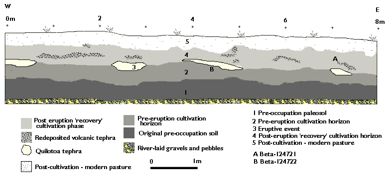
Figure 13. Profile drawing of sector 5 of the water pipeline trench cut, with phases of use
Figure 13. Profile drawing of sector 5 of the water pipeline trench cut, with phases of use

Figure 14. View of profile in sector 5 of water pipeline trench cut, showing
agricultural ditches infilled by Quilotoa tephra and redeposited ash in the post-eruption phase of use
View other images from pipeline trench in the gallery (nos. 36-40)
In sector 5, another area of volcanic ash lying at regular intervals was observed and a trench 8 m long and 1.5 m deep was excavated parallel to the original pipeline trench, about 20 m to the west of a large tola (see Figure 2). The northern side of the exposed profile was then cleaned back, drawn and photographed. The exposed profile revealed a rather different picture of the indigenous agricultural system and its response to the volcanic ash fall. A sequence of four shallow ditches about 20 cm in depth, spaced at regular intervals (approx. 2.5 m) and inflled with plugs of the greyish white volcanic tephra occurred at a depth of between 60 cm and 80 cm below the present day pasture. They had been cut into an original land surface (horizon 2) which was clearly visible as a dark brown horizon, itself overlying what was interpreted as an earlier, pre-occupation paleosol (1, see Figure 13).
The system was interpreted as a series of huachos (or wachuna/wachukuna, the local name used in Zuleta now, see Knapp 1991: 74 and 147-148), 'ridge and furrow' cultivation which is still the traditional method for the cultivation of maize and potatoes in the region to the present day. Ridge and furrow is narrower and shallower than the classic mounded camellones with their broad intervening ditches. The difference between this cultivation system and the raised beds of sector 4 was marked (compare Figures 11 and 12 with Figures 13 and 14 - n.b. all of these links will open a new window).
Much more ash was observed than in sector 4, with much ash mixed within the post-ash-fall soil. This gave the impression of either a less efficient original ash-clearance operation than that seen in sector 4, or, that the post-ash-fall fields were cultivated for a much shorter period of time and possibly reclaimed at a later period (therefore allowing less time for soil cultivation, natural weathering and biological processes to remove or otherwise incorporate the ash within the overall soil matrix).
Samples for soil chemical analysis and for micromorphology were taken from high up into the present day soil horizon, underlying the modern pasture, down through the entire profile and into the original soil. The results of the phosphate analysis gave high levels for the later, post-eruption cultivation horizon, medium readings for the pre-eruption cultivation phase and a weak reading for the pre-agricultural paleosol (note 3). The paleosol underlying the pre-eruption cultivation horizon was similar to the earliest land surface in sector 4. It showed no evidence of cultivation prior to the construction of the ridge and furrow system.
The analysis confirms that this ridge and furrow system was rather different to the camellones of sector 4. No significant fining of the soil matrix had occured within the pre-eruption cultivation horizon, as was observed in the sector 4 camellones. Tephra grains are much more evident in the soil matrix and the two dominant textural pedofeatures of these systems (silty and limpid clay coatings) although present, are far less evident and where present, are mutually exclusive, unlike the compound coatings of sector 4. The addition of fine mineral and organic inputs in the soil was not as marked as for the camellones in sector 4, supporting the view that the cultivation system in sector 5 was not as well developed as that in sector 4. This in turn suggests that it could have been cultivated over a shorter period of time or, that the soil management regime of the ridge and furrow system was less intensive than the camellones, or possibly both. The ash from the Quilotoa eruption appears to have remained upon the land surface for a longer period of time than in sector 4. This is witnessed by further ash deposits within the upper surface of the cultivation horizon as well as the channel infillings of tephra.
It also suggests that efforts to revive agricultural productivity were perhaps initially focussed upon the more productive camellones towards the centre of the valley. A short phase of post-eruption cultivation is indicated, not only by the cutting and turning over of the tephra, but by the translocation of rare silty and limpid clay coatings lining channels in the soil microstructure (Wilson and Simpson nd). This does not seem to have been long-lasting however, and the modern topsoil which developed above this post-eruption cultivation zone retains no evidence of cultivation.
An AMS radiocarbon date was obtained from charcoal lying immediately beneath the volcanic tephra (see Figure 13) which had infilled the ditch and it produced a date of 780 ±40 B.P. (Beta-124722; wood charcoal; 13C/12C= -26). Calibrated at 2 sigma (Pretoria Calibration Procedure program [Vogel et al 1993]) this produces a date range of cal A.D. 1205 -1290 (intercept at cal A.D. 1265). The horizon overlying the occupational ground surface and the ash-filled ditches contained what appeared to be plugs of ash cut out from new ditches and redeposited upside down against what possibly may be the sides of a new cultivation ridge, although given the mixing of these deposits with re-deposited ash, interpretation of this profile is difficult. Another AMS date on charcoal from this post-volcanic event reclamation phase yielded a date of 770 ±40 B.P. (Beta-124721; wood charcoal; 13C/12C=-26.6). Calibrated at 2 sigma (Intercal 98 [Radiocarbon 1998]) this produces a date range of cal A.D. 1185 - 1285 (intercept at cal A.D. 1255/ B.P. 695). Although the two AMS dates from immediately before the volcanic event and immediately following it cannot be differentiated with statistical validity, they are important for assisting in the dating of the Quilota eruption.
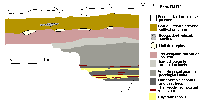
Figure 15. Profile drawing of sector 6 of the water pipeline trench cut, with
superimposed layers of tephra from Cerro Cayambe towards base
The trench excavated in sector 6 was east of the large tola referred to above. It was 8 m long and 2.5 m deep and revealed a sedimentary history that included an infilled lake bed with peat layers overlayed by up to three distinctive ash-fall horizons, later identified as coming from the neighbouring volcano Cerro Cayambe (Patricia Mothes, personal communication 1998). A sample of the peat underlying the ash was submitted for dating to assist in establishing a chronological framework for the site, within which the different depositions of tephra might be more readily placed. The sample yielded a date of 3450 ±60 B.P. (Beta-124723; peat; 13C/12C=-25.9). Calibrated at 2 sigma (Pretoria Calibration Procedure program [Vogel et al 1993]) this produces a date range of B.C. 1900 - 1615 (intercept at cal B.C. 1745) and assists in giving a timescale to the different depositional and soil formation processes underway in the valley.
Sector 6 appears to be right on the edge of the cultivated part of the valley. The remains of ash-filled ditches and redeposited volcanic ash occurred only in the easternmost end of the profile, and a clear reduction in the ditch and ash features was observed between the north and the south profiles, a matter of 1.5m apart. The southern profile was cleaned back, photographed and drawn and the usual sequences of samples for soil chemical analysis, micromorphology and palynology were taken. The results for these are not yet available.
Note 3: See note 1 for preceding section 4. The presence of a strong reading higher up in the soil profile here, closer to the modern topsoil, and lower reading further down into the pre-Hispanic cultivation system may perhaps suggest a distortion produced by the downward movement of modern phosphates, so these results should be interpreted with caution. Return to text
© Internet Archaeology
URL: http://intarch.ac.uk/journal/issue10/currie/4sec4a.html
Last updated: Thu Apr 5 2001