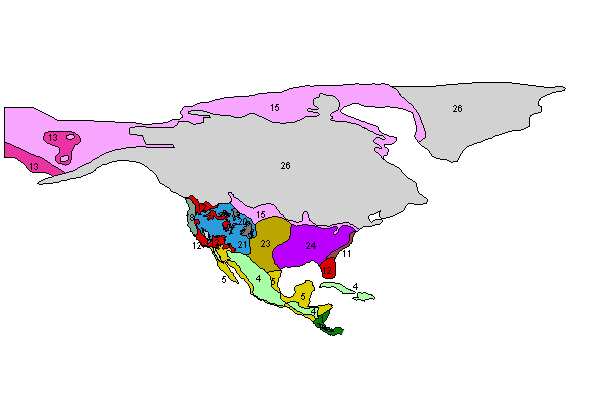
Figure 4: Map of North America (view legend)
In North America, the dominant feature was the presence of a vast ice sheet covering Canada. Forest dominated the eastern USA, but it was more open in character and contained trees adapted to the cooler climates.
Regionally specific altitudinal zones: in the Rockies in the west, altitudinal zones were lowered; for the LGM western USA montane mosaic region, between around 26 and 42 deg. N the following vegetation zones seem to have predominated - alpine tundra, above 2500m, subalpine parkland of open stands of spruce, pines and fir between 1500-2500m, and scrub/woodland below about 1500m (Tallis 1990). In the Cordillera region of the western USA, the areas below 500m altitude were 'semi-desert'.
Everything below 500m was semi-desert, and scrub in the 500-1500m range. Same for the whole 'desert' area to the south, covering Texas and northern Mexico; if below 500m the vegetation was ascribed to the semi-desert category, above 500m, it was reconstructed as scrub. In the Sierra Nevada of California, the areas above 2000m were labelled as ice (Tallis 1990).

Figure 4: Map of North America (view legend)
Barnosky et al. (1987); Barry (1987); Benson and Thompson (1987); Blum et al. (1994); Cole and Monger (1994); Delcourt and Delcourt (1987, 1991); Denton and Hughes (1981); Dyke and Prest (1986, 1987); Elias (1995, 2001); Forman et al. (1992); Graham and Mead (1987); Harris (1993); Herwitz (1992); Holliday (1987); Hopkins et al. (1982); Nordt et al. (1994); Overpeck et al. (1992); Plummer (1993); Richard (1995); Ritchie (1982); Ritchie and Cwynar (1982); Rochefort et al. (1994); Rosseau and Kukla (1994); Schwalb and Burns (1995); Schweger et al. (1982); Tallis (1990); Tchakerian (1994); Thompson and Mead (1982); Thompson and Anderson (2000); Watts (1980); Watts and Stuiver (1980); Webb et al. (1983); Webb et al. (1993); Wells (1992); Wilkins (1991); Williams et al. (2000); Woodcock and Wells (1990).
© Internet Archaeology
URL: http://intarch.ac.uk/journal/issue11/2/4.2.html
Last updated: Mon Dec 3 2001