Image: B-A1-3
Location: Site B, Area 1
Plan of Saxon features | Plan of Medieval features | Plan of Site B
Aspect: View looking NW
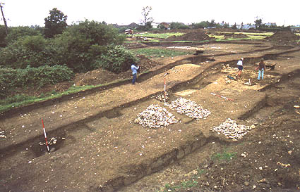
General view of Area 1 (south side of the defences), during the course of the excavation. The stone wall fronting the bank is under the two standing figures on the right, and the drawn section 1 on the baulk to the left of the central figure. (For a view of this area looking SW (right to left in this picture), see photo 1/2). The inner ditch filled with stones (cut by a modern intrusion), is in the centre of the photo, marked by a vertical ranging pole. (For detail, see photos 1/5, 1/4 and 1/3). These were thrown into the ditch at the time of the destruction of the wall in period 3. The pile of stones adjacent to the ditch has been recovered from the excavated section of the ditch on the line of section 1, and provided a sample of the stone types of which the wall was composed. The central Saxon ditch is sectioned to the left of the photo, marked by the vertical ranging pole, and is also partially filled with stones. (For a photo of this ditch as revealed on the other side of the narrow trench, see 1/12.)
The rest of Area 1, and part of Area 2, shows in the background.