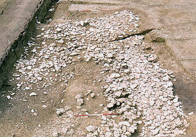
Image: B-A2-21
Location: Site B, Area 2
Plan of Saxon features | Plan of Medieval features | Plan of Site B
Aspect: View looking S
The intra-mural walkway in the south-west corner of the defences, in course of excavation (earlier state than that shown in photos 2/20 and 2/22. The inside edge of the western bank runs beyond the stones, right, and turns (east) at the far ranging pole. The walkway is cut by modern disturbance, left, and by a recent field drain (the black scar). The spread of stones on the inside of the walkway, towards the left and bottom left-hand corner - some of them large - is from the destruction in period 3A of an inferred wall at the crest of the bank. (See a view from the east in photo 2/20, and details in 2/17 and 2/18. Earlier states of the excavation are shown in photos 2/23, and 2/24.)