The Roman temple in the sanctuary of Asklepios at Empúries is the perfect candidate for conducting a GIS viewshed analysis. It was the largest of the temples in the precinct, was well excavated, and we can be certain that the temples of the sanctuary were not screened on all sides by topography or a surrounding portico. Its location on the highest point in Neapolis seems to suggest that it was placed there specifically to dominate the cityscape and to command an expansive view of the city.
Implementing a GIS viewshed analysis in a built landscape presents a unique problem as buildings of varying heights modify the natural landscape. In order to account for this modification, I assigned a height value to every structure in Neapolis based on published information and my own observations in the field. In the course of three field seasons I observed every wall, recording the material of which it was made, its thickness at the base, and whether there was any evidence for upper storeys in the form of the base of stairs or walls preserved to an appropriate height. Based on this information, I estimated the height of every excavated building at Empúries. In the rare instances where there was not enough preserved architectural information to make the necessary observations, I assumed that such buildings had only one storey, as the majority of excavated structures were made of mud-brick and had too narrow a stone socle to support multiple storeys. I also assumed that there were no trees or tall plants within the city wall capable of blocking the view.
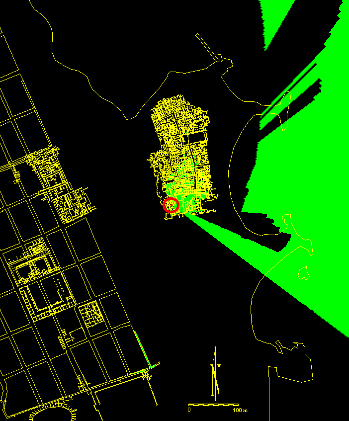
Figure 9: Viewshed analysis of the pediment of the Roman-era temple in the Asklepieion
In order to select as liberal parameters as possible for the visibility of this temple, I decided to determine from where in the city the roof and the upper portion of the front pediment of the temple could have been seen, not the entire temple façade. The results of the viewshed analysis are presented in Figure 9. The view-point on the top of the pediment of the temple is represented by the red dot in the circle. Anyone standing in the shaded areas during the first century CE could have seen the point on the top of the temple pediment in the Sanctuary of Asklepios represented by the dot. The areas shaded green within the blocks are of little concern since they would represent the roofs of buildings. The ancient Emporitani would have had to stand on the roofs of these buildings in order to see the temple pediment, something people would not have commonly done in a Roman city. In Roman literature the only time people go on the roofs of their homes is to perform or escape nefarious deeds (Plaut. Mil. 156-80; Val. Max. 2.1.2; App. B. Civ. 4.24). What is of interest are the green-shaded areas of the streets and plazas, as people would have traversed these on a regular basis and would have been able to see the temple pediment from any of the shaded streets or plazas. The result of the analysis is that it suggests the pediment of the temple, and therefore the entire temple façade, was not visible from most parts of Neapolis. It could have been seen from the south plaza and from the street leading to the south plaza from the south gate, but not from most other streets. The temple would have been virtually invisible from the streets of Neapolis because of the crowded nature of the structures in the city.
Nonetheless, the viewshed analysis proves that the temple did afford a view of the Gulf of Roses and the horizon. The builders of the temple may have orientated their building to provide this view intentionally as part of their ceremonies. Both Plutarch and Vitruvius suggest that worshippers at any temple ought to be able to see the eastern horizon for ritual purposes (Plut. Vit. Num. 14.4; Vitr. 4.5.1-2).
© Internet Archaeology
URL: http://intarch.ac.uk/journal/issue14/2/5.2.html
Last updated: Thu Jun 12 2003