Department of Archaeology, University of York, King's Manor, York, YO1 7EP, UK. [email protected]
Cite this as: Rahn, B. 2005 Cost Surface-Derived Least-Cost Paths: A Case Study from Iron Age Orkney, Internet Archaeology 19. https://doi.org/10.11141/ia.19.2
In recent years, GIS landscape models have begun to move towards more sophisticated techniques for representing the land surface in order to analyse site territories, pathways and travel costs. Many of the major commercial GIS packages now offer the ability to generate anisotropic cost surfaces. In addition, recent papers have proposed methodologies for generating cost surfaces to model social preferences affecting travel (Lee and Stucky 1998; Llobera 2000).
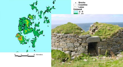
In terms of practical applications, however, GIS models of catchment areas and paths between sites continue to be dominated by those constructed on the basis of slope alone. In parallel with this, regional analyses of site location, with few exceptions, have been undertaken either within large land masses, largely ignoring the effects of rivers, lakes and the sea on travel costs and affordances, or within single islands, neglecting travel to other neighbouring islands or the mainland. The reasons for this appear to be twofold: first, there is little information available on travel costs and travel rates using pre-industrial transportation technology, beyond very general statements; second, critical analysis of what constitutes an 'acceptable' travel distance is lacking, especially in situations where both water and land transport are possibilities. This article presents some preliminary results from a research project examining the location and distribution of Middle Iron Age sites (brochs) in the landscape of Orkney, Northern Scotland. It employs a terrain model, taking into account differing friction values for land and water surfaces, as well as the nature of the shoreline (cliffs, beaches) and how this affects access from land to sea and vice versa. It also attempts to model pathways between sites following three friction models: lowest-energy, lowest-visibility (hidden) and highest-visibility (exposed).
Lee, J. and Stucky, D. 1998 'On applying viewshed analysis for determining least-cost paths on Digital Elevation Models', International Journal of Geographical Information Science 12, no. 8, 891-905.
Llobera, M. 2000 'Understanding movement: a pilot model towards the sociology of movement', in G.R. Lock (ed) Beyond the Map: Archaeology and Spatial Technologies, IOS Press, Oxford, 65-84.
Go to article Table of Contents
© Internet Archaeology
URL: http://intarch.ac.uk/journal/issue19/rahn_index.html
Last updated: Tue Dec 20 2005